3.3.2 Gletscher
en Glaciers
fr Glaciers
Mit folgenden Links wird von anderen Webseiten auf diese Seite verwiesen:
▶Gletscher| de | en | fr |
|---|---|---|
|
Auswirkungen des Klimas Gletscher |
Impacts of Climate Change Glaciers |
Impacts du changement climatique Glaciers |
Links zur Klimaschau
|
|
▶Gletscher |
|
|
▶Klima vor 10'000 Jahren bis heute - Das Holozän ▶Französische Klimapolitik ▶Gletscher |
⇧ de Verzeichnis en Contents fr Sommaire
⇧ Welt-Info
|
|
Gebirgsgletscher / Glaciers / Glaciers | |||||
| ▷Die Kalte Sonne Blog‑Themen Vahrenholt/Lüning ▶Die kalte Sonne | de ▷Gebirgsgletscher | |||||
| Science Skeptical Blog | de Schnee und Eis | |||||
| ►Der Wasserplanet (Ernst-Georg Beck) | de ▷Pole, Gletscher, Meeresspiegel (Wayback ohne Bilder) | |||||
| NoTricksZone | en Glaciers | |||||
| Wikipedia |
de
Gletscher en Glacier fr Glacier |
|||||
| Vademecum |
▶Gletscher
▶Welt-Info |
|||||
| Siehe auch |
|
⇧ de Allgemein en General fr Générale
-
World Climate Report en
Search: Glaciers/Sea Ice
2007-06-12 en A Kilimanjaro We-told-you-so
2007-06-26 en Mont Blanc Glaciers Refuse to Shrink?
2008-07-28 en Back to Africa: Kilimanjaro Update
![]()
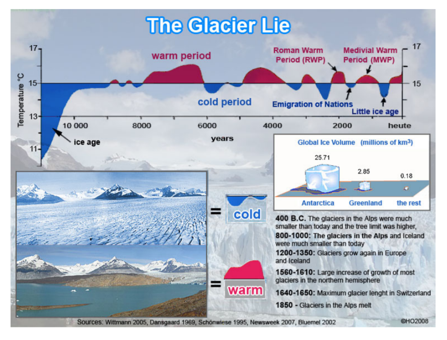
![]() Evidence that the recent climate change is within natural
variability:
Evidence that the recent climate change is within natural
variability:
10,000 years of changing warm and cold periods.
⇧ de Text en Text fr Texte
↑ Gletscher-Webseiten
de Verzeichnis der Gletscher-Webseiten
en Contents of the glacier websites
fr Sommaire des sites web des glaciers
- 2019
- de
Nasa-Studie: Gletscher in Grönland wächst plötzlich wieder
en Cold Water Currently Slowing Fastest Greenland Glacier - de
Gletschermanns Entdeckung
Alex Baur (Weltwoche)Der Berner Geologe Christian Schlüchter kennt die Geschichte der Gletscher wie kein anderer.
Doch seine Forschung kam den Prognosen des weltberühmten Professorenkollegen Thomas Stocker in die Quere.
- de
Warum Wolken der Fluch aller Klimaforscher sind
Hamburger Max-Planck-Forscher Stevens: "Unsere Computer sagen nicht einmal mit Sicherheit voraus, ob die Gletscher in den Alpen zu- oder abnehmen werden" - 2017
- de
«Grönland schmilzt» - oder doch nicht
Bundespräsidentin Doris Leuthard fliegt für eine PR-Aktion ins grönländische Eis - SRF liefert die Begleitmusik. - de ETH-Forscher: Schweizer Gletscher sind nicht mehr zu retten
- 2016
- de Einige Alpengletscher wachsen wieder. Und früher sind sie auch schon mal geschmolzen.
- 2015
- de Jetzt schmelzen die Gletscher im Höllentempo
- 2013
- de Überraschung im höchsten Gebirge der Erde: Karakoram-Gletscher wachsen seit Ende der 1980er Jahr
- 2014
- de Berner Geologe Christian Schlüchter: Alpengletscher endeten zu Zeiten Hannibals 300 Höhenmeter über dem heutigen Niveau
- de
«Unsere Gesellschaft ist grundsätzlich unehrlich»
Ein Stück Holz hat den Berner Geologen Christian Schlüchter in Konflikt mit der Klimaforschung gebracht. - 2012
- de
Gletschersterben
Das Lamento über den Rückzug des «ewigen Eises» - de
Ist die Sonne schuld am Klimawandel?
de Panik-Küche en Panic laboratory fr Marmite alarmiste
Heinz Wanner: Die Abwägung der wichtigen natürlichen und menschgemachten Einflüsse zeigt eine zunehmende Dominanz des Treibhauseffektesde Selbst Beurteilen! en Judge yourself! fr Jugez vous-même!
- 2010
- de
Gletscherforschung: Die Zeugen früheren Klimawandels
Alex Reichmuth (Weltwoche)Wanner bezeichnet Schlüchters Methode zwar als «spannend».
Trotzdem lässt er durchblicken, dass er nicht viel davon hält:
- 2009
- en Unprecedented Incoherence In The Ice Message
- 2008
- de Gletscherholz als Klimaarchiv
- 2007
- de NZZ: Was kümmern mich schmelzende Gletscher?
de Text der Gletscher-Webseiten
en Text of the glacier websites
fr Texte des sites web des glaciers
⇧ 2019
↑ Nasa-Studie: Gletscher in Grönland wächst plötzlich wieder
-
Die kalte Sonne (Fritz Vahrenholt & Sebastian Lüning)
2019-08-08 de Nasa-Studie: Gletscher in Grönland wächst plötzlich wiederÜberraschendes auf Spiegel Online am 29. März 2019:
Nasa-Studie: Gletscher in Grönland wächst plötzlich wieder
Über Jahrzehnte ist der Jakobshavn-Gletscher in Grönland geschrumpft.
Nun nimmt seine Eisdecke auf einmal wieder zu.
Forscher sind dem Rätsel auf die Spur gekommen.
Abertausende Eisberge sind bereits vom Jakobshavn-Gletscher in Grönland ins Meer gerutscht.
Einer von ihnen soll 1912 die "Titanic" versenkt haben.
Der Gletscher ist gewaltig, knapp sieben Prozent des gesamten grönländischen Eises fließen über ihn ab - und das so schnell wie an keinem anderen.
Seit 20 Jahren schrumpft der Jakobshavn-Gletscher mit großer Geschwindigkeit und trägt so zum Anstieg des Meeresspiegel bei.
Doch nun gibt es eine überraschende Kehrtwende,
berichtet die amerikanische Weltraumbehörde Nasa.
Der Gletscher fließe nun langsamer und werde wieder dicker, hieß es.
Statt sich zunehmend ins Inland zurückzuziehen, bewege er sich in Richtung Meer.
Entwarnung gibt es aber nicht:
Laut den Forschern lässt das Eis des Jakobshavn die Ozeane weiter ansteigen - nur nicht mehr ganz so stark.
"Am Anfang konnten wir es gar nicht glauben", sagt Ala Khazendar von der Nasa.
"Wir sind eigentlich davon ausgegangen, dass es so weiter geht wie in den vergangenen 20 Jahren."
Quellen/Sources:
-
Spiegel Online
2019-03-29 de Gletscher in Grönland wächst plötzlich wiederÜber Jahrzehnte ist der Jakobshavn-Gletscher in Grönland geschrumpft.
Nun nimmt seine Eisdecke auf einmal wieder zu.
Forscher sind dem Rätsel auf die Spur gekommen.
-
NASA
2019-03-25 en Cold Water Currently Slowing Fastest Greenland GlacierNASA research shows that Jakobshavn Glacier, which has been Greenland's fastest-flowing and fastest-thinning glacier for the last 20 years, has made an unexpected about-face.
Jakobshavn is now flowing more slowly, thickening, and advancing toward the ocean instead of retreating farther inland.
The glacier is still adding to global sea level rise - it continues to lose more ice to the ocean than it gains from snow accumulation - but at a slower rate.
↑
Gletschermanns Entdeckung
en
Cold Water Currently Slowing Fastest Greenland Glacier
Mit folgenden Links wird von anderen Webseiten auf diese Seite verwiesen:
-
Die Weltwoche / Alex Baur
2019-07-10 de Gletschermanns EntdeckungDer Berner Geologe Christian Schlüchter kennt die Geschichte der Gletscher wie kein anderer.
Doch seine Forschung kam den Prognosen des weltberühmten Professorenkollegen Thomas Stocker in die Quere.
Er sei Geologe, sagt Christian Schlüchter zur Begrüssung, «stellen Sie mich um Himmels willen nicht als Gletscherforscher vor».
Die Glaziologen bekämen sonst Wallungen.
Schlüchter wurde zwar weit über die Landesgrenzen hinaus bekannt wegen seiner Erkenntnisse über die Geschichte der Gletscher.
Doch diese waren an sich bloss ein Nebenprodukt seiner geologischen Forschungen.
Welch ein Affront für die Gletscherforscher.
Und als ob das nicht schon genug wäre, fuhr Schlüchter - nolens volens - mit seiner Gletschergeschichte auch noch den Klimaprognostikern in die Parade.
Und mit den Klimakennern ist erst recht nicht zu spassen.
Doch es ist, wie es ist:
Die «verrückte Familiengeschichte» (Schlüchter) der Gletscher
steht quer zu den Klimamodellen von Thomas Stocker,
seinem weltberühmten Professorenkollegen an der Universität Bern.
Unsere Gletscher, so Schlüchters zentrale Erkenntnis,
waren in den letzten 10'000 Jahren die meiste Zeit kleiner als 2005.
Es gab mindestens zwölf Wärmephasen seit der letzten Eiszeit.
Das konnte er aufgrund von Holzstämmen und Torfstücken nachweisen, welche die schmelzenden Eiskolosse freigegeben hatten, oberhalb der heutigen Waldgrenze notabene.
Seine Forschungen zeigen zudem: Die Klimaerwärmung ist kein linearer, sondern ein exponentieller Prozess mit vielen Faktoren, über deren Wechselwirkung wir zu wenig wissen.
Mit dem Wissen kamen die Fragen
Schlüchter hat nie behauptet, der Mensch hätte keinen Einfluss aufs Klima.
Er gehört nicht einmal zu jenen Skeptikern, welche die alarmierenden Prognosen des Weltklimarates (IPCC) für übertrieben halten.
Aus der Sicht der Alarmisten ist es noch schlimmer:
Schlüchter ist ein Agnostiker.
Nach seiner Meinung ist der Mensch weit davon entfernt, die Gründe für die Temperaturschwankungen zu kennen.
Denn je tiefer er in die Geheimsphäre der Gletscher und in die vertrackte Geschichte des Klimas vordrang, desto mehr neue Fragen und Ungereimtheiten kamen zum Vorschein.
Der Kardinalfehler der IPCC-Modelle
besteht nach Schlüchters Ansicht darin, dass man sich auf die menschengemachten Faktoren kapriziert.
Alles andere werde ausgeblendet.
In der real existierenden Welt gibt es aber viele denkbare Faktoren,
die in einer komplizierten Wechselwirkung miteinander stehen.
Klar ist für Schlüchter nur eines:
Wenn man die abrupten Klimaschwankungen und die sie bedingenden Kippeffekte zwischen den Eiszeiten nicht schlüssig erklären kann,
sind Prognosen für die nächsten 50, 100 oder auch 500 Jahre so zuverlässig wie Kaffeesatzlesen.
Und das ist natürlich ein Affront sondergleichen in einer Zeit, in der gemäss landläufiger Doktrin jeder, der an der Unfehlbarkeit des Weltklimarates zweifelt, lächerlich gemacht und in die Schandecke der Leugner verbannt gehört.
Wir treffen Professor Schlüchter in einem abgelegenen Bauernhaus im Berner Emmental oberhalb von Lützelflüh.
Der kräftige, leicht untersetzte und bärtige Mann mit dem stets wachsamen und festen Blick passt perfekt zu diesem Gehöft aus Gotthelfs Zeiten.
Hier wurde er 1947 geboren, hier besuchte er die Grundschulen.
Das Gymnasium absolvierte er in Burgdorf.
1966 ging er nach Bern, um Geologie zu studieren.
Es folgten Studien in Deutschland, später forschte Schlüchter rund um den Erdball.
Doch die Erdung auf der Emmentaler Scholle, hat man den Eindruck, die kam ihm nie abhanden.
«Das Glück war mir hold», fasst Christian Schlüchter sein Leben zusammen, «alles war Zufall und nochmals Zufall.»
Es war ein Zufall, dass just Anfang der 1970er Jahre, als er sein Studium beendet hatte, überall Autobahnen entstanden.
Schneisen wurden in die Landschaft gegraben, Kiesgruben ausgebaggert.
Für einen Geologen war es das Paradies auf Erden:
«Plötzlich konnten wir in die Höger reinschauen.»
Zufälligerweise war es auch die Zeit, als die C14-Methode (Radiokarbondatierung) entwickelt wurde.
Es war ein Meilenstein für die Erkundung der Erdgeschichte.
Und zufälligerweise fand der junge Geologe in Bern hochkarätige Professoren - etwa den Botaniker Max Welten, den Geologen Rolf Rutsch, die Mineralogin Emilie Jäger oder den Physiker Hans Oeschger -, die den Wissbegierigen über alle Schrebergärten hinweg fachübergreifend förderten.
Denn um die geologischen Verschiebungen über die Jahrtausende zu erforschen, reichte ein Spezialgebiet nicht.
Mit der Radiokarbonmethode etwa halfen ihm die Physiker, das Alter von Fundstücken in den Kiesgruben und Moränen zu bestimmen; mit Hilfe der Botaniker wiederum konnte er aufgrund von Pollen oder Hölzern, die er in geologischen Ablagerungen fand, die Vegetation einer bestimmten Epoche ergründen.
Damit konnte man sich ein Bild machen von einem Thema, das damals nur ein paar Aficionados elektrisierte, zufälligerweise aber bald in aller Munde sein sollte: das Klima.
Schlüchter war einer, der sich lieber auf den Schutthalden der Gletscher herumtrieb als in den Bibliotheken und Hörsälen.
Die Arbeiter in den Kiesgruben, von denen er manch einen mit dem Zauber der Geologie infizierte, waren seine treusten Verbündeten.
Bis heute kommt es immer wieder mal vor, dass ihn einer anruft, weil er im Kies auf eine seltsame Formation, einen Findling oder einen vielleicht seit Jahrtausenden eingeschlossenen Baumstamm stösst.
Dieses Holz hatte es Schlüchter schon immer angetan.
Für ihn waren diese Fundstücke gleichsam die Agenden, mit denen er die Geschichte der Veränderungen datieren konnte.
Die Baumarten und Jahrringe waren für ihn wie Wetterstationen.
In unbestechlicher Präzision hatten sie die klimatischen Bedingungen vergangener Epochen aufgezeichnet.
Urban vs. knorrig
Dabei begann alles mit einem gewaltigen Flop.
Mitte der 1970er Jahre fand Schlüchter unter einer Grundmoräne ein Holzstück, dessen Alter im Labor auf 19'500 Jahre datiert wurde.
Es war eine Sensation, weil der Brügel an einem Ort lag, wo er nie hätte liegen dürfen.
Musste man die Geschichte umschreiben?
Nachkontrollen in München ergaben dann aber, dass man sich um Jahrtausende verrechnet hatte.
Das Holzstück war durch organisches Material «verunreinigt», welches aus einer anderen Schicht durchgesickert war.
Es war peinlich, ja, doch sein Ruf nahm keinen Schaden.
Denn Wissenschaft beruhte, damals zumindest noch, auf dem Prinzip von Versuch und Irrtum.
Das war nicht so schlimm, weil die allein seligmachende wissenschaftliche Wahrheit noch nicht erfunden war.
Dumm war nur, wer seine Irrtümer nicht sehen wollte oder vertuschte, statt daraus zu lernen.
Christian Schlüchter wurde 1993 ordentlicher Professor an der Universität Bern.
Das war just die Zeit, als der Umweltphysiker Thomas Stocker am Physikalischen Institut in die Fussstapfen des legendären Hans Oeschger trat.
Stocker hatte sein Handwerk an der ETH Zürich und später an der Columbia University gelernt.
Seine Spezialität waren computergestützte Klimamodelle, die ihn später an die Spitze des Weltklimarates katapultieren sollten.
An der Seite des Klimaaktivisten Al Gore durfte er 2007 im Kollektiv des IPCC den Friedensnobelpreis entgegennehmen.
Die ebenso famosen wie umstrittenen historischen CO2-Kurven von Al Gore waren in Stockers Institut entstanden.
Schlüchter und der zwölf Jahre jüngere Stocker, das sind zwei Welten, die unterschiedlicher kaum sein konnten.
Man muss es sich bildlich vor Augen führen:
Auf der einen Seite der urbane und eloquente Filius der katholischen Zürcher Konditorendynastie Stocker, einer,
der am liebsten im Büro hinter Computern an seinen Modellen werkelte und sich in den internationalen Gremien bewegt wie ein Fisch im Wasser;
auf der anderen Seite der knorrige Bauernbursche aus dem urprotestantischen Emmental,
dem es im Zelt auf den unwirtlichen Gletscherhalden im Himalaja, in der Antarktis, im tiefen Anatolien, in den Alpen oder in den Hochanden am wohlsten ist;
einer, der grundsätzlich allem misstraut, was er nicht mit den eigenen Händen anfassen und mit den eigenen Augen sehen kann.
Jahrelang ergänzten sich die beiden Antipoden ganz leidlich, publizierten sogar zusammen.
Während Stocker beim IPCC die Karriereleiter hochkletterte,
machte Schlüchter in den 1990er Jahren Funde in den Alpen, welche die Geschichte der Gletscher umschreiben sollten.
Und wieder führte der Zufall Regie.
Zwischen 1980 und 1990 waren die meisten Alpengletscher vorübergehend wieder gewachsen.
Seit dem Ende der Kleinen Eiszeit (um 1850) hatte es noch zwei weitere solche Wachstumsphasen gegeben.
Das hatte vor allem mit den Niederschlägen zu tun (der schnellste Gletscherrückgang wurde übrigens im aussergewöhnlich sonnigen Sommer 1947 gemessen).
Entscheidend war:
Der vorübergehende Vorstoss in den 1980er Jahren pflügte die Vorfelder der Gletscher auf und förderte, auch via Schmelzwasserbäche,
massenweise Holz- und Torfstücke zutage,
die vorher während Jahrhunderten oder Jahrtausenden vergraben gewesen und unter hermetischem Verschluss konserviert worden waren.
Zusammen mit seinen Studenten schleppte Schlüchter mehrere tausend Fundstücke aus dem ganzen Alpenraum in die Labors.
So entstand über die Jahre eine detaillierte Geschichte der Gletscher bis zurück in die letzte Eiszeit.
Nicht alle freute das.
Denn die Realität, die der Gletschermann auf dem Feld gefunden hatte, passte immer weniger zu den Klimamodellen des IPCC.
2004 kam es zu einer ersten offenen Kontroverse.
«Hör auf mit diesem Seich», so soll Stocker damals seinen Kollegen im trauten Kreis entnervt beschworen haben.
Wie ernst war das gemeint?
Auf jeden Fall war es nur ein Vorgeschmack auf das, was noch kommen sollte.
Als die Gletscher kleiner waren
Nach der Jahrtausendwende kamen neue Messmethoden auf.
Es konnten nun die Zeiträume bestimmt werden, in denen Gesteinsoberflächen der kosmischen Strahlung ausgesetzt gewesen waren.
Die Felsen, welche die schmelzenden Gletscher freigaben, sprachen wiederum eine klare und deutliche Sprache:
Im frühen Mittelalter oder etwa in der Römerzeit waren die Gletscher viel kleiner als heute, und zwar nicht nur in Europa, sondern weltweit.
In der Öffentlichkeit wurden Schlüchters Forschungen zwar kaum wahrgenommen.
Und er war auch nicht erpicht auf einen Showdown, solange man ihn forschen liess.
Doch an der Universität im mittlerweile zutiefst rot-grünen Bern sorgten die Erkenntnisse des kauzigen Emmentalers, die sich nicht an die offiziellen Modelle hielten, für zunehmende Irritation.
Im Juni 2014 provozierte Christian Schlüchter mit einem ausführlichen Interview in der Zeitung Der Bund einen Eklat.
Schon der vieldeutige Titel («Unsere Gesellschaft ist grundsätzlich unehrlich») versprach Zoff.
Schlüchter legte seine Erkenntnisse sehr detailliert dar.
Zu den Modellen des IPCC äusserte er sich nicht direkt.
Er wies aber darauf hin,
dass sich die zum Teil dramatischen Wärme- und Kältephasen der letzten 12'000 Jahre nicht mit dem CO2 erklären liessen,
dass es viele denkbare Theorien und wenig Gesichertes gebe - und dass man erst das Vergangene begreifen sollte, bevor man die Zukunft prognostiziere.
Es sei schwierig geworden, Forschungsergebnisse zu publizieren, welche der offiziellen Klimadoktrin widersprechen, klagte Schlüchter.
Er plädiere zwar auch für einen schonenden Umgang mit den Ressourcen,
doch mehr Sorgen als das Klima bereite ihm der Zustand der Forschung:
«Viele Naturwissenschafter sind heute Zudiener von Politikern.»
Und weiter:
«Es gibt in der Geschichte viele Beispiele für das Versagen der Naturwissenschaft, weil der Mut gefehlt hat.»
Und zu Professor Stockers Aussage, man habe nur noch die Wahl zwischen zwei und vier Grad Erwärmung, meinte er trocken:
«Die Erfindung des Teufels war die grandioseste Erfindung, die die Menschheit je gemacht hat.
Man kann viel Geld verdienen, wenn man ihn an die Wand malt.»
Bienen und Enkel
Professor Thomas Stocker reagierte mit einer scharfen Replik.
Wenn sein «langjähriger Kollege» mit Holzresten, die er «aus den schmelzenden Gletschern hervorholt», das Weltklima erklären wolle,
dann sei das «weder wissenschaftlich noch seriös».
Es gebe eine «einfache quantitative Erklärung für den weltweit dokumentierten Gletscherschwund:
den vom Menschen verursachten Klimawandel, also den Anstieg der CO2-Konzentration». Und basta.
Stocker warf Schlüchter mangelnde Verantwortung vor,
weil er mit seinen Äusserungen «der Verharmlosung des globalen Klimawandels» Vorschub leiste.
Nach diesem kurzen und heftigen Aufflammen einer Kontroverse wurde es wieder ruhig.
Schon 2012 war der Störfaktor Christian Schlüchter wegpensioniert worden.
Heute kümmert er sich, fidel wie eh und je, vor allem um seine Bienen und seine Enkel.
Mit Schlüchter verschwand einer der letzten Vertreter der alten Garde aus der Universität Bern
und mit ihm die vermaledeiten Baumstämme und Torfstücke, welche die Modelle stören.
Es herrscht Eintracht.
Man fragt sich bloss, wozu denn noch weiter übers Klima geforscht werden soll - wo doch schon alles wissenschaftlich gesichert ist.
|
|
![]() Aletsch-Gletscher im Verlaufe der letzten ca. 3'500 Jahre
Aletsch-Gletscher im Verlaufe der letzten ca. 3'500 Jahre
| de | en | fr |
|---|---|---|
|
Auswirkungen des Klimas Gletscher |
Impacts of Climate Change Glaciers |
Impacts du changement climatique Glaciers |
↑
Warum Wolken der Fluch aller Klimaforscher sind
Hamburger Max-Planck-Forscher Stevens:
"Unsere Computer sagen nicht einmal mit Sicherheit voraus, ob die
Gletscher in den Alpen zu- oder abnehmen werden"
-
Spiegel (Printausgabe) / Johann Grolle
2019-03-22 de Warum Wolken der Fluch aller Klimaforscher sindVorhersagen zur Erderwärmung sind noch immer erstaunlich ungenau.
Supercomputer und künstliche Intelligenz sollen helfen.
Die Klimasensitivität
Es ist eine schlichte Zahl, doch wird sie das Schicksal dieses Planeten bestimmen.
Sie ist leicht zu beschreiben, doch vertrackt schwierig zu berechnen.
Die Forscher nennen sie: "Klimasensitivität".
Sie gibt an, um wie viel sich die Durchschnittstemperatur auf der Erde erwärmt, wenn sich die Konzentration der Treibhausgase in der Atmosphäre verdoppelt.
Schon in den Siebzigerjahren wurde sie mithilfe primitiver Computermodelle ermittelt.
Die Forscher kamen zu dem Schluss, dass ihr Wert vermutlich irgendwo zwischen 1,5 und 4,5 Grad liegen dürfte.
An diesem Ergebnis hat sich bis heute, rund 40 Jahre später, nichts geändert.
Und genau darin liegt das Problem.
Die Rechenleistung der Computer ist auf das Vielmillionenfache gestiegen, aber die Vorhersage der globalen Erwärmung ist so unpräzise wie eh und je.
"Es ist zutiefst frustrierend", sagt Bjorn Stevens vom Hamburger Max-Planck-Institut für Meteorologie.
Seit mehr als 20 Jahren forscht er nun schon auf dem Feld der Klimamodellierung.
Kommentar und weitere Auszüge:
-
Die kalte Sonne (Fritz Vahrenholt & Sebastian Lüning)
2019-03-30 de Hamburger Max-Planck-Forscher Stevens:
"Unsere Computer sagen nicht einmal mit Sicherheit voraus, ob die Gletscher in den Alpen zu- oder abnehmen werden"Die Klimamodelle stehen weiter in der Kritik.
Sie haben weder die Abbremsung der Erwärmung zu Beginn der Jahrtausendwende kommen sehen,
noch gelingt es ihnen, die Temperaturentwicklung der letzten Jahrtausende zu reproduzieren.
Die Print-Ausgabe des Spiegel brachte am 22. März 2019 einen ausgezeichneten Beitrag über die Probleme der Klimamodelle.
Der Artikel von Johann Grolle ist leider nur für Abonnenten zugänglich, aber er ist es wert, den Gratismonat zu aktivieren bzw. das Heft zu bestellen.
Hier einige Auszüge:
Warum die Vorhersagen zur Erderwärmung so schwierig sind
Vorhersagen zur globalen Erwärmung sind noch immer erstaunlich ungenau. Supercomputer und künstliche Intelligenz sollen helfen.
Zur Klimasensitivität
Schon in den Siebzigerjahren wurde [die Klimasensitivität] mithilfe primitiver Computermodelle ermittelt.
Die Forscher kamen zu dem Schluss, dass ihr Wert vermutlich irgendwo zwischen 1,5 und 4,5 Grad liegen dürfte.
An diesem Ergebnis hat sich bis heute, rund 40 Jahre später, nichts geändert.
Und genau darin liegt das Problem.
Die Rechenleistung der Computer ist auf das Vielmillionenfache gestiegen, aber die Vorhersage der globalen Erwärmung ist so unpräzise wie eh und je.
"Es ist zutiefst frustrierend", sagt Bjorn Stevens vom Hamburger Max-Planck-Institut für Meteorologie.
Stevens hat selbst viel beigetragen zum Fortschritt. Und doch musste er sich immer wieder aufs Neue eingestehen, dass seine Zunft, was die Vorhersage des Klimawandels betrifft, auf der Stelle tritt.
Um sich jedoch konkret auf das Kommende vorzubereiten, taugten die Modelle der Klimaforscher nicht.
Als Entscheidungshilfe beim Bau von Deichen und Entwässerungskanälen seien sie ungeeignet.
"Unsere Computer sagen nicht einmal mit Sicherheit voraus, ob die Gletscher in den Alpen zu- oder abnehmen werden", erklärt Stevens.
Die Schwierigkeiten, denen sich er und seine Forscherkollegen gegenübersehen, lassen sich in ein Wort fassen:
Wolken.
Die träge über den Himmel ziehenden Gebirge aus Wasserdampf
sind der Fluch aller Klimaforscher.
Die Forscher können in ihren Modellen das Wasser nicht verdunsten, aufsteigen und kondensieren lassen, so wie es dies in der Wirklichkeit tut.
Sie müssen sich mit mehr oder weniger plausiblen Faustregeln behelfen.
"Parametrisierung" heißt das Verfahren, doch die Forscher wissen:
In Wirklichkeit ist das der Name einer chronischen Krankheit, von der all ihre Klimamodelle befallen sind.
Oft liefern sie drastisch voneinander abweichende Ergebnisse.
Die Temperaturen in der Arktis zum Beispiel klaffen in den verschiedenen Modellen um teilweise mehr als zehn Grad auseinander.
Das lässt jede Prognose der Eisbedeckung wie bloße Kaffeesatzleserei erscheinen.
Einstweilen allerdings ist nur gewiss, dass die Menschheit noch einige Zeit auf handfestere Klimaprognosen wird warten müssen.
Und selbst wenn sich die Wolken irgendwann den Gleichungen der Forscher fügen,
wird die Welt dann sicher vor Überraschungen sein?
Keiner der beiden Forscher mag da Entwarnung geben.
"Wir betreten unkartiertes Terrain", sagt Schneider.
"Da gibt es keine Gewissheiten."
|
|
⇧ 2017
↑ «Grönland schmilzt» - oder doch nicht
-
Basler Zeitung / Dominik Feusi
2017-08-09 de «Grönland schmilzt» - oder doch nichtBundespräsidentin Doris Leuthard fliegt für eine PR-Aktion ins grönländische Eis - SRF liefert die Begleitmusik.
Meeresspiegelanstieg
In einer gleichentags auf Radio SRF ausgestrahlten Sendung weist Steffen noch darauf hin, dass durch das Abschmelzen der weltweite Meeresspiegel
bis zum Jahr 2100 um «bis zu einem Meter» ansteigen wird.
Die Prognose ist die schlimmstmögliche Berechnung im schlimmstmöglichen von Forschern beschriebenen Szenario.
Es beruht auf unrealistischen Annahmen, nämlich einem rund dreimal höheren Anstieg des Meeresspiegels pro Jahr als Steffen selber angibt.
Ein Meter ist immerhin deutlich weniger als die frei erfundenen sechs bis sieben Meter Meeresanstieg, die der frühere amerikanische Vizepräsident Al Gore behauptete.
Das hindert Steffen und SRF nicht daran, Gores Besuch bei Steffen im Fernsehbeitrag zu erwähnen - um zu unterstreichen, wie wichtig Konrad Steffen und das «Swiss Camp» in Grönland seien.
Wie viel Eis schmilzt nun genau?
Steffen beziffert das Abschmelzen im Radiobeitrag mit 365 Kubikkilometer Eis pro Jahr.
Und weil sich darunter niemand etwas vorstellen kann, sagt er, das sei das sechsfache des Eisvolumens in den Alpen.
Der Vergleich mit den Alpen macht nur Sinn, um die Alarmstimmung aufrecht zu halten.
Hätte Steffen das Schmelzen nämlich ins Verhältnis zum Eisvolumen von Grönland gestellt, immerhin fast drei Millionen Kubikkilometer, so hätte er zugeben müssen,
dass die behauptete Schmelze nur gut ein Zehntel eines Promilles beträgt (0,12 Promille).
Das heisst, dass es auch in mehreren Tausend Jahren noch Eis in Grönland geben dürfte
und die Prognose von Steffen und den Moderatoren von SRF, dass Grönland «schmelze», noch sehr lange nicht eintrifft.
Es ist kompliziert
Eigentlich ist alles viel komplizierter.
Klar ist nur, dass sich das Klima ändert, aber das ist nichts Neues.
Es gibt Hinweise darauf, dass sich der Fluss des Eises in Grönland beschleunigt.
Wie das jedoch genau passiert und wieso, ist noch nicht vollständig geklärt.
Und es gibt Regionen, in denen das Eis tatsächlich schmilzt.
Zum Beispiel dort, wo Steffens «Swiss Camp» steht.
Aber genauso gibt es Regionen, in denen das Eis wächst.
Ausgerechnet im letzten Jahr wuchs es fast überall.
Wäre Steffen ein seriöser Wissenschaftler, hätte er auf die vielen offenen Fragen hingewiesen.
Und ein seriöser Sender hätte ihn dazu befragt, statt seine Behauptungen ungeprüft zu übernehmen.
↑ ETH-Forscher: Schweizer Gletscher sind nicht mehr zu retten
-
NZZ Online
2017-08-03 de ETH-Forscher: Schweizer Gletscher sind nicht mehr zu rettenDie Gletscher in der Schweiz sind angesichts des Temperaturanstiegs nach Expertenangaben nicht mehr zu retten.
Selbst mit den grössten Anstrengungen zur CO2-Verringerung würden 80 bis 90 Prozent der Eismassen bis 2100 schmelzen.
⇧ 2016
↑ Einige Alpengletscher wachsen wieder. Und früher sind sie auch schon mal geschmolzen.
-
Die kalte Sonne (Fritz Vahrenholt & Sebastian Lüning)
2016-04-29 de Einige Alpengletscher wachsen wieder. Und früher sind sie auch schon mal geschmolzen.
⇧ 2015
↑ Jetzt schmelzen die Gletscher im Höllentempo
de Panik-Küche en Panic laboratory fr Marmite alarmiste
de
Im Namen des vom Menschen verursachten Klimawandels
en
In the Name of Human Caused Climate Change
fr
Au nom du changement climatique anthropique
-
SRF Schweizer Radio und Fernsehen
2015-08-03 de Jetzt schmelzen die Gletscher im Höllentempo
Noch nie schmolzen die Gletscher rascher als in den ersten zehn Jahren des 21. Jahrhunderts.
Der Welt-Gletscher-Beobachtungsdienst an der Universität Zürich kommt zu dramatischen Ergebnissen:
Bei gleichbleibendem Klimawandel werden bis Ende des Jahrhunderts 90 Prozent des Eises verschwunden sein.
Seit über 120 Jahren vermessen Wissenschaftler weltweit die Gletscher in grösster Präzision.
Die Daten gehen zur Analyse an den Welt-Gletscher-Beobachtungsdienst der Universität Zürich.
Dessen Direktor Michael Zemp spricht von dramatischen neuesten Befunden:
«Im Moment verlieren wir mit Blick auf die globalen Gletscher 75 Zentimeter an Eisdicke pro Jahr. Das ist doppelt so viel wie in den 1990er Jahren und das Dreifache der 1980er Jahre.
Das erste Jahrzehnt des 21. Jahrhundert hat damit laut Zemp die grösste je festgestellte Gletscherschmelze gebracht.
Dahinter stehe ganz klar der mutmasslich vom Menschen verursachte Klimawandel.
Die von einigen Forschern zurzeit diskutierte Verlangsamung der Klimaerwärmung lasse sich jedenfalls an den Gletschern nicht erkennen.
Im Gegenteil: Sie schrumpften schneller.
Kommentare
-
Die Weltwoche / Alex Reichmuth
2012-01-04 de GletschersterbenDas Lamento über den Rückzug des «ewigen Eises»
Steigen die Temperaturen in diesen Tagen über dreissig Grad, wird auch das Lamento über den Rückzug des «ewigen Eises» wieder einsetzen.
Unzählige Medienbeiträge beklagen das «Gletschersterben» - gerade so, als wären die Eiszungen Persönlichkeiten.
«Die Gletscher in Grindelwald leiden derzeit täglich», titelte SRF.
Stets folgen düstere Mahnungen von «Fachleuten», endlich dem Klimawandel Einhalt zu gebieten.
Welch ein Unsinn!
Seit Jahrtausenden stösst die Gletscherbedeckung vor oder zieht sich - zurück.
Noch bis ins 19. Jahrhundert beteten Bergbewohner zu Gott, er möge die Gletscher stoppen.
Ihre Sorgen waren berechtigt, überfuhren doch wachsende Eiszungen regelmässig wertvolles Weideland oder machten ganze Siedlungen platt.
Schmelzende Gletscher aber bedrohen nichts und niemanden.
Selbstverständlich verändern sich, übers Jahr gesehen, die Pegelstände von Bächen und Flüssen, wenn in höheren Regionen Eismassen verschwinden.
Das kann heissen, dass die Wasserversorgung in landwirtschaftlichen Gebieten angepasst werden muss oder dass die Bedingungen für die Gewinnung von Energie wechseln.
Doch es bleiben Jahrzehnte für entsprechende Veränderungen.
Wären fehlende Gletscher eine Bedrohung, wie es ständig suggeriert wird, müssten in Regionen ohne Eis Notstände herrschen - schon seit Jahrhunderten.
Aber die Teile der Alpen, in denen schon heute Gletscher fehlen, sind weder verödet, noch leiden deren Bewohner Durst.
Eindrückliches Naturspektakel
Natürlich kann man es bedauern, wenn die majestätischen Gletscher allmählich verschwinden.
Doch nach und nach werden sich Bergwälder ausbreiten, wo heute Schutt und Geröll dominieren.
Wer die atemberaubende Herrlichkeit alpiner Arven- und Föhrenwälder unter der Baumgrenze kennt, weiss, dass allenfalls Schönheit durch Schönheit abgelöst wird.
Es warten «blühende Landschaften», um einen von Altkanzler Helmut Kohl in ganz anderem Zusammenhang geprägten Begriff zu bemühen.
Kommt dazu, dass der Gletscherschwund so oder so weitergehen wird.
Auch wenn der Klimawandel stoppt und die Temperaturen wie in den letzten achtzehn Jahren stagnieren, wird das Schmelzen noch Jahrzehnte anhalten.
Der Rückzug der Gletscher ist keine Katastrophe, sondern vielmehr ein eindrückliches Naturspektakel.
⇧ 2014
↑ Berner Geologe Christian Schlüchter: Alpengletscher endeten zu Zeiten Hannibals 300 Höhenmeter über dem heutigen Niveau
-
Die kalte Sonne (Fritz Vahrenholt & Sebastian Lüning)
2014-06-11 de Berner Geologe Christian Schlüchter: Alpengletscher endeten zu Zeiten Hannibals 300 Höhenmeter über dem heutigen NiveauImmer mehr Geologen erkennen, dass ihr Wissen dringend in der Klimadiskussion gebraucht wird.
Ein gutes Beispiel ist der Berner Geologe Christian Schlüchter, der am 6. Juni 2014 im Interview mit Bernhard Ott in der Tageszeitung Der Bund die Fakten zur Gletscherschmelze in den Alpen gerade rückte.
Im Folgenden ein Auszug aus dem augenöffnenden Gespräch, das sie unbedingt in voller Länge auf derbund.ch lesen sollten:
|
|
![]() Aletsch-Gletscher im Verlaufe der letzten ca. 3'500 Jahre
Aletsch-Gletscher im Verlaufe der letzten ca. 3'500 Jahre
| de | en | fr |
|---|---|---|
|
Auswirkungen des Klimas Gletscher |
Impacts of Climate Change Glaciers |
Impacts du changement climatique Glaciers |
↑
«Unsere Gesellschaft ist grundsätzlich unehrlich»
Ein Stück Holz hat den Berner Geologen Christian Schlüchter in Konflikt
mit der Klimaforschung gebracht.
-
Der Bund / Bernhard Ott
2014-06-07 de «Unsere Gesellschaft ist grundsätzlich unehrlich»Ein Stück Holz hat den Berner Geologen Christian Schlüchter in Konflikt mit der Klimaforschung gebracht.
«Die Zeit, die wir betrachten, ist doch viel zu kurz»: Geologe Christian Schlüchter will den Klimawandel nicht dramatisieren
Herr Schlüchter, Sie haben aufgrund der Analyse von Holzfunden im Vorfeld von Gletschern herausgefunden, dass Hannibal bei der Überquerung der Alpen meist durch den Wald, aber nie über Gletscher ging.
Das ist pointiert ausgedrückt.
Mit Hannibal wurde ich im Laufe meiner Forschungen aber tatsächlich konfrontiert.
Ein Freund sagte mir, dass ich die Öffentlichkeit darauf vorbereiten sollte, vom hehren Bild der Alpen mit Gletschern im Abendrot Abschied zu nehmen - zugunsten einer «hannibalistischen Welt».
Was meinen Sie mit «hannibalistischer Welt»?
Die Waldgrenze lag viel höher als heute, Gletscher gab es kaum.
In keinem der detaillierten Reiseberichte aus der Römerzeit werden Gletscher erwähnt.
Den ersten Holzfund machten Sie am Steingletscher im Sustengebiet.
Es habe sie «tschuderet», sagten Sie später.
Wie haben Sie das gemeint?Bis in die 90er-Jahre beschränkte sich die Gletscherforschung auf eine Datierung der Gletschervorstösse und Moränenstände.
Dabei ging vergessen, was zwischen den Vorstössen geschah.
Man kannte nur 50 Prozent der Gletschergeschichte.
Und plötzlich stiess ich auf dieses Holz, wenige Meter vor dem Gletscher.
Es war zerschlissen, als ob jemand mit einem stumpfen Beil daran gearbeitet hätte.Mir war sofort klar:
Das ist ein Dokument, wie man es bisher noch nie gefunden und analysiert hatte.
Der Baum musste älter sein als die Kleine Eiszeit (1400 bis 1850). Ich liess ihn umgehend im Labor datieren.
Und wie alt war er?
Knapp über 4000 Jahre alt.
Was haben Sie sich dabei gedacht?
Ich müsse weitere Belege finden.
Kurz darauf war ich mit Studierenden im Val Malenco im Veltlin, wo wir auf ein Seelein vor einem kleinen Gletscher stiessen.
Das Gewässer wurde gestaut von einer Moräne aus der Kleinen Eiszeit.
In deren Erosionsrillen fanden wir zusammengedrückte Sedimente eines weiteren Sees mit organischen Spuren.
Diese waren praktisch gleich alt wie das Holz am Steingletscher.
Das heisst: Vor der Kleinen Eiszeit gab es bereits ein Seelein, das dann vom Gletscher zugedeckt wurde.
Zwei Jahre später fand ich zahlreiche Hölzer am Unteraargletscher.
Seither habe ich mehr oder weniger regelmässig weitere Belege gefunden.
Dort, wo heute der Unteraargletscher liegt, war einst grüne Fläche?
Es war eine Landschaft mit einem breiten, verwilderten Fluss.
Wir fanden auch viele über 2000-jährige Torfstücke.Haben Sie je daran gedacht, dass 10'000 Jahre Erdgeschichte neu geschrieben werden müssten?
Nein, nein. Das wäre vermessen.
Die holozäne Gletschergeschichte war ja nicht mein primäres Forschungsgebiet.Aber bis dahin ging man ja von einem Rückgang der Gletscher seit dem Ende der Eiszeit aus?
Ja, mehr oder weniger, mit etwas oszillierenden Gletscherzungen. Man hat sich aber nicht überlegt, was zwischen den Vorstössen geschehen ist. Es hat mich fasziniert, mehr über die Rückzugsphasen der Gletscher zu erfahren.
Die Reaktionen auf Ihre Entdeckungen waren harsch.
Der Berner Klimaforscher Heinz Wanner hielt Ihnen vor, aus Holz- und Torfanalysen alleine könne man keine Rückschlüsse auf die Bewegungen der Gletscher schliessen.
Dazu brauche es Energie- und Massenbilanzen.
Ich hätte das Holz gar nicht finden dürfen, weil ich nicht zum engeren Kreis der Holozän- und Klimaforscher gehöre.
Meine Funde haben daher viele Experten auf dem falschen Fuss erwischt:
Jetzt hat ein «Laie» etwas gefunden, was die Holozän- und Klimaforscher hätten finden müssen.
Also ging es bloss um Forscherneid, und die Einwände waren haltlos?
Ich würde das nicht so ausdrücken.
Wir hatten am Anfang aber Mühe, Publikationsmöglichkeiten in wissenschaftlichen Zeitschriften zu finden.So mussten wir die ersten Beiträge in methodischen Publikationen unterbringen.
Wieso sollte es Massenbilanzen brauchen, wie Wanner sagte?
Ein Gletscher geht zurück, wenn die Masse schwindet.
Wenn die Masse wieder zunimmt, stösst auch der Gletscher vor.
Die Lage der Gletscherzunge ist ein leicht verzögertes Abbild der Massenbilanz.
Haben Sie das Gespräch mit Herrn Wanner gesucht?
Wir haben uns öfters darüber unterhalten.
Er hat mir schliesslich anvertraut, dass er aus einem unserer Aufsätze zitiert habe. Das ist eine Ehre für uns.Sie standen in einem fremden Gärtchen herum?
Das ist etwas zugespitzt formuliert.
Ich habe ein Leben lang geforscht, was Gletscher mit ihrer Unterlage machen.
Dabei habe ich mir zwangsläufig auch Gedanken über die Gletschergeschichte gemacht.Wir haben zum Beispiel eine andere Datierungsmethode entwickelt als die gängige C-14-Methode, die auf organischen Materialien basiert.
Mit unserer Methode kann man das Alter einer geologischen Oberfläche bestimmen.
Das waren die Forschungen an der Felskante des Rhonegletschers beim Hotel Belvédère?
Genau.
Diese Publikation hatte für grosses Aufsehen gesorgt.
Wir wollten prüfen, ob die vom Rhonegletscher freigegebene Felsfläche schon einmal der kosmischen Strahlung ausgesetzt war.
War der Gletscher schon einmal so klein wie heute?
Ist das messbar anhand der Isotopen an der Oberfläche des Gesteins?
Die Resultate waren klar und eindeutig.
Die Felskante war in den letzten 10'000 Jahren während 5800 Jahren eisfrei.
Dann ist der heutige Zustand des Gletschers der Normalfall?
Der Gletscher war mehrheitlich gar noch kleiner.
Vorher hiess es bei unseren Publikationen jeweils: «Der Schlüchter ist wieder einmal holzen gegangen.»
Nun war klar, dass unsere Forschungsergebnisse sich nicht nur auf die Altersbestimmung von Holz stützten.
Von da an konnten wir ungehindert publizieren.
Ein Jahr später fanden wir im Vorfeld des Glacier du Mont Miné im Wallis riesige Stämme.
Bei der Altersbestimmung konnte festgestellt werden, dass diese Bäume innerhalb eines Jahres gestorben sind.
Das war das zweite Mal, dass es mich «tschuderet» hat.
Der Gletscher stiess sehr rasch vor?
Vielleicht wurden die Bäume nicht vom Gletscher direkt, sondern von Murgängen gefällt.
Das Todesjahr konnte exakt auf 8195 Jahre vor heute datiert werden.
Die Sauerstoffisotope im grönländischen Eis zeigen um 8200 Jahre vor heute eine markante Abkühlung.
Damals stiessen die meisten Gletscher in Grönland rasch vor.
Unsere Funde am Glacier du Mont Miné zeigten, dass dieses Kälteereignis offenbar auch die Alpen erfasste.
Deshalb kamen Sie zum Befund, dass die Bewegungen der Gletscher vor allem von der Aktivität der Sonne abhängen?
Nein, darauf kam ich schon vorher.
Aber von da an konnten unsere Forschungen nicht mehr negiert werden.
Der UNO-Weltklimarat prophezeite 2001, dass die Alpengletscher im Jahr 2100 weitgehend verschwunden sein werden.
Ihre Forschungen stehen da quer in der Landschaft?
Ich würde das nicht so formulieren.
Wir haben Folgendes gezeigt:
Erdgeschichtliche Erwärmungsphasen waren stets intensiv, rasch und von Katastrophen begleitet.
Heute befinden wir uns immer noch in einer exponentiellen Zunahme der Erwärmung nach der Kleinen Eiszeit.
Laut UNO-Weltklimarat kommt zusätzlich zur erdgeschichtlichen Erwärmung aber noch die vom Menschen gemachte dazu?
Richtig.
Aber es gilt zu bedenken, dass das System extrem dynamisch ist und nicht linear funktioniert.
Die Gletscher rücken nicht friedlich vor, bleiben eine Weile liegen und gehen dann zurück.
Warum bewegten sie sich in den letzten 200 Jahren denn viel dynamischer als vorher?
Das trifft so nicht zu.
Man kannte früher nur Bruchstücke der Geschichte und wusste nicht, dass das System so dynamisch ist.
Mitte des 19. Jahrhunderts war der Höchststand der Kleinen Eiszeit, die Gletscher waren vorgerückt.
Dann fielen sie zurück.
In den 1980er-Jahren gab es aber erneut Vorstösse.
Der Rückgang Mitte des 19. Jahrhunderts fiel doch mit dem Beginn der Industrialisierung zusammen?
Diese Frage ist bis heute nicht beantwortet:
Wieso gingen die Gletscher Mitte des 19. Jahrhunderts zurück, obwohl der grosse CO2-Anstieg in der Atmosphäre erst später kam?
Warum «kippte» die Erde in derart kurzer Zeit in eine Erwärmungsphase?
Warum gab es in den 1880er-, 1920er- und 1980er-Jahre wieder Vorstösse?
Ein berühmter Klimaforscher liess in den 1980er-Jahren in «Bund» und BZ verlauten, uns stehe die nächste Eiszeit bevor.
Es schleckt aber keine Geiss weg: Der Gletscherschwund ist rasant.
Ja. So katastrophal wie am Ende der letzten Eiszeit.
Aber das System funktioniert nicht linear.
Früher oder später muss die Klimaforschung die Frage beantworten, warum der Rückgang der Gletscher am Ende der Kleinen Eiszeit um 1850 derart rasch eingesetzt hat.
Das CO2 spielte keine Rolle für den Gletscherschwund?
CO2 spielt eine Rolle.
Aber man kann es nicht zur alleinigen Ursache erklären, ohne die Vorstösse der Gletscher in den 1980er-Jahren zu erklären.
Zudem müsste man erklären, welche Rolle das CO2 bei den grossen erdgeschichtlichen «Wendepunkten» zum Beispiel vor 115'000 Jahren spielte.
Da gab es ja noch keine Menschen.
Eben.
Warum wurde es da kälter?
Warum wurde es vor 17'500 bis 18'000 Jahren wieder wärmer?
Ich negiere nichts, ich will aber wissenschaftliche Antworten auf diese Fragen.
Sie führen die Gletscherbewegungen auf die Sonnenaktivität zurück.
Da müssten wir heute in einer Phase grosser Sonnenaktivität sein.
Auf der Nordhalbkugel sind wir heute in einer Phase mit Abkühlungstendenzen.
Trotzdem gehen die Gletscher zurück.
Viele sind überzeugt, dass der Mensch dafür verantwortlich ist.
Für mich persönlich ist das nicht die zentrale Frage.
Unsere Gesellschaft ist grundsätzlich unehrlich.
Man spricht immer vom «Hockey-Stick», der eine lange Phase konstanter Temperaturen mit einer exponentiellen Erwärmung in den letzten 100 Jahren anzeigt.
Aber es ist eigentlich ein «Double-Stick», weil man auch die Bevölkerungszunahme zeigen müsste.
Darüber spricht aber niemand.
Der Konnex zwischen Erderwärmung und Bevölkerungszunahme wird nicht gemacht.
Warum ist eine menschliche Ursache der Klimaerwärmung für Sie nicht zentral? Sind Sie ein Zyniker?
Nein, ganz im Gegenteil.
Aber wir wissen noch so wenig, wenn wir nicht erklären können, warum die alpinen Gletscher am Ende der Kleinen Eiszeit zurückgingen.
Und warum die Kleine Eiszeit überhaupt angefangen hat.
Haben die Römer mit Heizen aufgehört, sodass es weniger CO2 in der Atmosphäre gab?
Nach dem Untergang des Römischen Reiches ging es kulturell ja schon etwas bachab.
Das ist jetzt aber auch zynisch. Die Zeit, die wir betrachten, ist doch viel zu kurz.
Beim sogenannten Klimagate vor ein paar Jahren wurde ein Mail eines Wissenschaftlers publik, der schrieb, man müsse die Kleine Eiszeit wegdefinieren.
Genau diese Diskussion berührt mich nicht, weil sie nicht ehrlich ist.
Es geht wohl um Geld.
Es geht auch um Geld für Forschung und Renommee.
Unterstellen Sie den Forschern des UNO-Weltklimarates politisches Kalkül?
Ich wurde einmal aus Versehen an ein Meeting in England eingeladen.
Die Diskussion dort war sehr denkwürdig.
Sie wurde von jemandem des East Anglia Climate Center geführt, das wegen der publizierten E-Mails im Zuge von «Klimagate» in die Kritik geraten war.
Der Gesprächsleiter sprach als eine Art Vater.
Er setzte sich auf einen Tisch vor der versammelten Gemeinde und nahm die Messages entgegen.
Diese kommentierte er entweder wohlwollend oder ablehnend.
Zuletzt ging es um Tipps, wie man welches Gesuch an welcher Stelle für bestimmte Forschungen formuliert.
Für mich war es beeindruckend, zu sehen, wie der Gesprächsleiter Informationen gesammelt und selektioniert hat.
Mir geht es auch um die Glaubwürdigkeit der Naturwissenschaft.
Die Naturwissenschaft wird korrumpiert?
Viele Naturwissenschafter sind heute Zudiener von Politikern, aber nicht mehr Naturwissenschafter, denen es um neues Wissen und Daten geht. Und das macht mir Sorge. Es gibt in der Geschichte viele Beispiele für das Versagen der Naturwissenschaft, weil der Mut gefehlt hat. Dasselbe gilt auch für andere Disziplinen, aktuell zum Beispiel für die Ökonomie.
Und heute sind wir wieder in einer Situation, in der man gewisse Möglichkeiten im Voraus ausschliesst?
Es gibt schon Fragen, die tendenziell (noch) ausgeblendet werden. Mehr und mehr jungen Forschern wird aber bewusst, dass der Stellenwert der Forschung sinkt, je mehr sie sich der Politik ausliefert.
Laut einem weiteren Berner Klimaforscher, Thomas Stocker, haben wir nur noch die Wahl zwischen einer Erderwärmung um zwei oder um vier Grad.
Ist das Hysterie?
Die Erfindung des Teufels war die grandioseste Erfindung, die die Menschheit je gemacht hat.
Man kann viel Geld machen, wenn man ihn an die Wand malt.
Andererseits wären die möglichen Auswirkungen einer Erwärmung auf eine so komplexe und verwöhnte Gesellschaft wie die heutige gravierend - vergleichbar mit der Situation, die die Völkerwanderung ausgelöst und das Römische Reich zum Einsturz gebracht hat.
Ist es nicht beängstigend, wenn die Gletscher im Jahr 2100 weg sind?
Sie kommen wieder, weil wir auf der Nordhalbkugel noch im Modus der Eiszeit sind.
Die Gleichgewichtslinie, also die Linie zwischen Nähr- und Zehrgebiet eines Gletschers, lag zu Zeiten Hannibals mindestens 300 bis 350 Höhenmeter höher als heute.
Die Durchschnittstemperatur lag anderthalb Grad über jener von 2005.
Erdgeschichtlich ist die jetzige Entwicklung nicht neu.
Gab es in der Römerzeit auch aufgetaute Permafrostböden, Murgänge und gefährdete Verkehrswege?
Murgänge gibt es in der Phase des Übergangs von kalt zu warm. Danach sind diese Böden wieder stabil. Das geht oft vergessen. Unsere Infrastruktur heute ist aber viel verletzlicher als damals.
Die Alpen ohne Permafrostböden wären kein Drama?
Mittelfristig nicht.
Kurzfristig ist es für Bauten in diesen Böden dramatisch.
Ist die Wasserversorgung durch den Gletscherschwund nicht gefährdet?
Auf die Reserven der Wasserversorgung hätte das einen Einfluss, da der Gletscher als Speicher entfällt.
Auf die Wasserversorgung als solche nicht.
Es ist unwahrscheinlich, dass es in den Alpen keinen Niederschlag mehr gibt.
Werden die Kinder Ihrer Enkel dereinst noch Gletscher erleben?
Ich versuche meinen Enkeln zu vermitteln, dass der Mensch nicht der Herr des Universums ist.
Ich ermahne sie zu einem schonenden Umgang mit unseren Ressourcen, zum Beispiel dem Wasser.
Man muss nicht jeden Tag duschen.
Und ich versuche ihnen zu zeigen, dass sich die Umwelt verändert.
Trotzdem traten Sie als Kronzeuge gegen die Klimaerwärmung in der «Weltwoche» auf.
Ich habe mich nie politisch eingemischt.
Sie traten an SVP-Versammlungen als Gastreferent auf.
Ich habe vor allen Parteien gesprochen - nicht immer über «Eis und Holz».
Nochmals: Was steckt hinter den Gletscherschwankungen?
Am Hebel der Veränderungen steht die Sonnenaktivität.
Zudem spielen tektonische Bewegungen und die Verschiebung der Jahreszeiten in der Nordhemisphäre eine Rolle.
Ein Auslöser können auch Vulkane sein.
|
|
![]() Aletsch-Gletscher im Verlaufe der letzten ca. 3'500 Jahre
Aletsch-Gletscher im Verlaufe der letzten ca. 3'500 Jahre
| de | en | fr |
|---|---|---|
|
Auswirkungen des Klimas Gletscher |
Impacts of Climate Change Glaciers |
Impacts du changement climatique Glaciers |
⇧ 2013
↑ Überraschung im höchsten Gebirge der Erde: Karakoram-Gletscher wachsen seit Ende der 1980er Jahr
-
Die kalte Sonne (Fritz Vahrenholt & Sebastian Lüning)
2013-11-04 de Überraschung im höchsten Gebirge der Erde: Karakoram-Gletscher wachsen seit Ende der 1980er Jahr
⇧ 2012
↑ Gletschersterben
-
Die Weltwoche / Alex Reichmuth
2012-01-04 de GletschersterbenDas Lamento über den Rückzug des «ewigen Eises»
Steigen die Temperaturen in diesen Tagen über dreissig Grad, wird auch das Lamento über den Rückzug des «ewigen Eises» wieder einsetzen.
Unzählige Medienbeiträge beklagen das «Gletschersterben» - gerade so, als wären die Eiszungen Persönlichkeiten.
«Die Gletscher in Grindelwald leiden derzeit täglich», titelte SRF.
Stets folgen düstere Mahnungen von «Fachleuten», endlich dem Klimawandel Einhalt zu gebieten.
Welch ein Unsinn!
Seit Jahrtausenden stösst die Gletscherbedeckung vor oder zieht sich - zurück.
Noch bis ins 19. Jahrhundert beteten Bergbewohner zu Gott, er möge die Gletscher stoppen.
Ihre Sorgen waren berechtigt, überfuhren doch wachsende Eiszungen regelmässig wertvolles Weideland oder machten ganze Siedlungen platt.
Schmelzende Gletscher aber bedrohen nichts und niemanden.
Selbstverständlich verändern sich, übers Jahr gesehen, die Pegelstände von Bächen und Flüssen, wenn in höheren Regionen Eismassen verschwinden.
Das kann heissen, dass die Wasserversorgung in landwirtschaftlichen Gebieten angepasst werden muss oder dass die Bedingungen für die Gewinnung von Energie wechseln.
Doch es bleiben Jahrzehnte für entsprechende Veränderungen.
Wären fehlende Gletscher eine Bedrohung, wie es ständig suggeriert wird, müssten in Regionen ohne Eis Notstände herrschen - schon seit Jahrhunderten.
Aber die Teile der Alpen, in denen schon heute Gletscher fehlen, sind weder verödet, noch leiden deren Bewohner Durst.
Eindrückliches Naturspektakel
Natürlich kann man es bedauern, wenn die majestätischen Gletscher allmählich verschwinden.
Doch nach und nach werden sich Bergwälder ausbreiten, wo heute Schutt und Geröll dominieren.
Wer die atemberaubende Herrlichkeit alpiner Arven- und Föhrenwälder unter der Baumgrenze kennt, weiss, dass allenfalls Schönheit durch Schönheit abgelöst wird.
Es warten «blühende Landschaften», um einen von Altkanzler Helmut Kohl in ganz anderem Zusammenhang geprägten Begriff zu bemühen.
Kommt dazu, dass der Gletscherschwund so oder so weitergehen wird.
Auch wenn der Klimawandel stoppt und die Temperaturen wie in den letzten achtzehn Jahren stagnieren, wird das Schmelzen noch Jahrzehnte anhalten.
Der Rückzug der Gletscher ist keine Katastrophe, sondern vielmehr ein eindrückliches Naturspektakel.
↑ Ist die Sonne schuld am Klimawandel?
de Panik-Küche en Panic laboratory fr Marmite alarmiste
-
Naturwissenschaften Schweiz
2012 de Heinz Wanner: Ist die Sonne schuld am Klimawandel?Die Abwägung der wichtigen natürlichen und menschgemachten Einflüsse zeigt eine zunehmende Dominanz des Treibhauseffektes
Alle paar Jahre erscheinen Publikationen, welche ausschliesslich die Sonne für den Klimawandel verantwortlich machen.
Dies hat eine gewisse Logik, weil das Klimasystem der Erde durch die Energieleistung der Sonne angetrieben wird.
Allerdings berücksichtigen diese Studien oft nicht, dass sich die Mischung der natürlichen und menschgemachten Antriebs- und Störungsfaktoren dauernd verändert.
Dadurch wird nicht nur die Energiebilanz der Erde beeinflusst.
Auch die atmosphärische Zirkulation, die Temperatur und der Niederschlag sind dauernden Schwankungen unterworfen.
Dieses Faktenblatt bespricht die Einflussfaktoren der Sonne über verschiedene Zeitskalen.
Die durch die Sonneneinstrahlung erzeugte Energieleistung pro Fläche (im Fachausdruck Energieflussdichte genannt) wird in Watt pro m2 ausgedrückt.
Bezogen auf den Einfluss der Sonne müssen zwei verschiedene Einflussfaktoren unterschieden werden.
Einerseits betrifft dies die langfristige räumliche Veränderung der Energieleistung auf unserer Erdkugel aufgrund der sich verändernden Elemente der Erdbewegung (elliptische Bahn um die Sonne, Schiefe und Kreiselbewegung der Erdachse).
Andererseits müssen die Schwankungen der Strahlungsleistung der Sonne - einfach ausgedrückt sind dies die Schwankungen der Leuchtstärke der "Sonnenlampe" - beachtet werden.
de Selbst Beurteilen! en Judge yourself! fr Jugez vous-même!
Unterschied zwischen direkter und indirekter Wirkung der Sonne
| de | en | fr |
|---|---|---|
|
Fehler der Klimamacher, Teil I Unterschied zwischen direkter und indirekter Wirkung der Sonne |
Errors, Part I Difference between the influence of Solar brihgtness and Solar activity |
Erreurs, partie I Différence entre l'influence du rayonnement solaire et de l'activité solaire |
Der Solarverstärker
| de | en | fr |
|---|---|---|
| Die Sonne | The Sun | Le soleil |
| Solarverstärker | Solar amplifier | Amplificateur du soleil |
| de | en | fr |
|---|---|---|
| Fehler der "Klimamacher", Teil I | Errors of the "Climatemakers", Part I | Erreurs des "faiseurs du climat", partie I |
| IPCC ignoriert den Solar-Verstärker | IPCC ignores the Solar amplifier | L'amplificateur du soleil est ignoré par le GIEC |
Kosmische Strahlung und Wolkenbildung
| de | en | fr |
|---|---|---|
|
Klimawandel: Wissenschaft Wasserdampf / Wolken |
Climate change: Science Water vapor / Clouds |
Changement climatique: Science Vapeur d'eau / nuages |
|
Wolkenforschung, Korrelation zwischen der kosmischen Strahlung und der Wolkenbildung, Korrelation zwischen Wolken und Temperatur, Der Wasserdampfverstärker für das CO2, Das Geheimnis der Wolken. |
||
Ursache des Klimawandels
Der CO2-Treibhauseffekt
| de | en | fr |
|---|---|---|
|
Klimawandel: Wissenschaft Der CO2-Treibhauseffekt |
Climate change: Science The CO2 Greenhouse Effect |
Changement climatique: Science L'éffet de serre du CO2 |
| Einleitung | Introduction | Introduction |
| Die Klimasensitivität von CO₂ | Climate sensitivity of CO₂ | La sensibilité climatique du CO₂ |
|
Die CO₂-Sättigung: Wenn die CO₂-Konzentration zunimmt, ist die Erwärmung wegen der Sättigung kleiner |
The CO₂ Saturation: As Carbon Dioxide increases it has less Warming Effect |
La saturation du CO₂: Lorsque la concentration du CO₂ augmente, son effet de réchauffement diminue |
| Der Streit um die Rückkopplungen | The argument about the feedbacks | L'argument des rétroactions |
| Der fehlende Hotspot (warme Zone) | The missing Hotspot | Le 'hotspot' (point chaud) manque |
| ERBE Earth Radiation Budget Experiment | ERBE Earth Radiation Budget Experiment | ERBE Earth Radiation Budget Experiment |
| de | en | fr |
|---|---|---|
|
Klimawandel: Wissenschaft Steigende Temperatur bewirkt CO2-Anstieg (nicht umgekehrt! - zuerst kommt die Temperatur!) |
Climate Change: Science Temperature responsible for CO2 rise (not the other way round!) |
Changement climatique: Science La température fait monter le CO2 (pas le contraire!) |
| de | en | fr |
|---|---|---|
| Kohlenstoffdioxid (CO2) | Carbon dioxide (CO2)" | Dioxyde de carbone (CO2)" |
|
Der CO2-Sättigungseffekt Wenn die CO2-Konzentration zunimmt, hat es einen kleineren Erwärmungseffekt |
Der CO2-Sättigungseffekt As Carbon Dioxide increases it has less Warming Effect |
Der CO2-Sättigungseffekt Lorsque la concentration du CO2 augmente, son effet de réchauffement diminue |
Einfluss der Sonne
| de | en | fr |
|---|---|---|
| Klimawandel: Ursachen | Climate change: Causes | Changement climatique: Causes |
| Solarer Einfluss in der Klima-Geschichte | Solar impact in Climate History | Impact solaire dans l'histoire du climat |
| de | en | fr |
|---|---|---|
|
Klimawandel: Probleme IPCC ignoriert den Einfluss der Sonne |
Climate change: Problems IPCC ignores the influence of the sun |
Changement climatique: Problèmes Le GIEC ignore l'influence du soleil |
Ozeanzyklen steuern das Klima
| de | en | fr |
|---|---|---|
|
Klimawandel: Wissenschaft Ozeanzyklen & Ozeanische Oszillationen |
Climate change: Science Ocean Cycles & Ocean Oscillations |
Changement climatique: Science Cycles et oscillations océaniques |
| Ozeanzyklen steuern das Klima / El Niño (der Knabe/warm) & La Niña (das Mädchen/kalt) / ENSO: El Niño-Southern Oscillation / AMO: Atlantic Multidecadal Oscillation / NAO: North Atlantic Oscillation / AO: Arctic Oscillation / IOD: Indischer Ozean Dipol / PDO: Pacific decada oscillation | ||
Verstärkungseffekte & Rückkopplungen
| de | en | fr |
|---|---|---|
|
Fehler der Klimamacher, Teil I Falscher CO2-Verstärkungseffekt des IPCC |
Errors, Part I Wrong CO2 Amplifying Effekt of the IPCC |
Erreurs, partie I Faux effet d'amplification du CO2 du GIEC |
| Der Streit um die Rückkopplungen | The argument about the feedbacks | L'argument des rétroactions |
⇧ 2010
↑ Gletscherforschung: Die Zeugen früheren Klimawandels
-
Die Weltwoche 2010/15 / Alex Reichmuth
2010-04-14 de Gletscherforschung: Die Zeugen früheren KlimawandelsGletscherforscher Schlüchter: «Es ist einfach vieles durch die Sonne gesteuert»:
Der Rückgang der Alpengletscher gilt als dramatisch und bedrohlich.
Holz- und Torfstücke beweisen aber, dass in den letzten Jahrtausenden die Alpen meist grüner waren als heute.
Die Erkenntnisse eines Berner Forschers relativieren die Aufregung um die Erderwärmung.
Wie reagieren Forscherkollegen auf seine Erkenntnisse?
Darüber will Schlüchter nicht sprechen.
Er deutet aber an, dass es negative Reaktionen gegeben hat.
Wilfried Haeberli, Professor für Geografie und Glaziologe an der Universität Zürich,
geht auf die Frage der Weltwoche nach der Bedeutung von Schlüchters Erkenntnissen nicht direkt ein.
Offenbar hält er sie aber nicht für gross, denn Haeberli betont, dass sich die Gletscher und Eisfirne in den letzten zwanzig Jahren anders entwickelt hätten als jemals zuvor in den vergangenen Jahrtausenden.
...
Gleich argumentiert auch Heinz Wanner, Wissenschaftler am Berner Oeschger-Zentrum für Klimaforschung:
Aufgrund der abnehmenden Sonneneinstrahlung sei heute eigentlich mit einer grösseren Eisbedeckung als vor einigen Jahrtausenden zu rechnen.
Heute würden die Gletscher somit wegen des menschengemachten Klimawandels schmelzen.
Wanner bezeichnet Schlüchters Methode zwar als «spannend».
Trotzdem lässt er durchblicken, dass er nicht viel davon hält:
Man könne aufgrund der Fundorte von Holz- und Torfstücken nicht genau sagen, wie weit zurück die Gletscher zu einem bestimmten Zeitpunkt geschmolzen waren.
Im Weiteren arbeite eine «moderne Glaziologie» zwingend mit Berechnungen zur Energie- und Massenbilanz der Gletscher, was bei Schlüchters Methode mit den Hölzern leider fehle.
Nur auf Basis von solchen Bilanzberechnungen könne man aber «präzise Aussagen» für die Vergangenheit und Zukunft der Gletscher machen.
Christian Schlüchter bezweifelt hingegen, dass die Wissenschaft heute präzise die Vergangenheit und die Zukunft der Gletscher vorhersagen könne.
Eine offene Frage sei etwa, warum die gegenwärtige Gletscherschmelze bereits 1850 eingesetzt habe, weit bevor das vom Menschen emittierte CO2 einen Einfluss auf das Klima gehabt haben kann.
Es stört ihn auch, dass bei Prognosen über die weitere Entwicklung der Gletscher lange deren Rückgang der letzten 150 Jahre einfach linear in die Zukunft fortgesetzt worden sei:
«Das ist Unsinn.» Niemand könne wissen, wie sich die Gletscher weiterentwickelten.
Es habe zum Beispiel in den 1980er Jahren Vorstösse gegeben, die niemand vorausgesehen habe und die auch niemand erklären könne.
Die etablierten Klimaforscher prognostizieren jedoch, dass bis Ende des 21. Jahrhunderts die Alpengletscher bis auf wenige Reste zusammenschmelzen werden.
Schlüchter geht auf Distanz:
«Die Entwicklung von Gletschern ist komplex.
Ich erachte solche Prognosen als nicht sehr wissenschaftlich.»
Ein Abschmelzen könne langsamer, durchaus aber auch schneller erfolgen - niemand wisse das.
Im jüngsten Bericht des Weltklimarats von 2007 ist vor kurzem eine ebenfalls sehr unwissenschaftliche Prognose aufgedeckt worden:
diejenige, dass die Gletscher im Himalaja bis 2035 fast vollständig abschmelzen könnten.
Es dauerte allerdings fast drei Jahre, bis die «moderne Glaziologie» diese krasse Fehlprognose aufdeckte und erkannte, dass sie sich einzig auf einen wissenschaftlich ungeprüften Bericht einer Umweltschutzorganisation abstützte.
Im Vergleich dazu erscheint Schlüchters Methode mit der Datierung von gefundenen Holz- und Torfresten beruhigend bodenständig:
zwar begrenzt in ihrer Aussagekraft, aber gerade darum umso vertrauenerweckender.
|
|
![]() Aletsch-Gletscher im Verlaufe der letzten ca. 3'500 Jahre
Aletsch-Gletscher im Verlaufe der letzten ca. 3'500 Jahre
| de | en | fr |
|---|---|---|
|
Auswirkungen des Klimas Gletscher |
Impacts of Climate Change Glaciers |
Impacts du changement climatique Glaciers |
⇧ 2009
↑ en Unprecedented Incoherence In The Ice Message
-
Whats Up With That? (Antony Watts)
2009-05-05 en Unprecedented Incoherence In The Ice Message
⇧ 2008
↑ Gletscherholz als Klimaarchiv
-
SRF Schweizer Fernsehen
2008-10-23 de Gletscherholz als KlimaarchivDer Gletscherschwund bietet Naturwissenschaftlern auch die Chance für neue Erkenntnisse. So liegt unter den Gletschern konserviert jahrtausendealtes Holz, gewachsen, als keine Zivilisation die Atmosphäre beeinflusste und die Erde dennoch wärmer war als heute.
gletscherg2g
de Gletscherholz als Klimaarchiv
⇧ 2007
↑ NZZ: Was kümmern mich schmelzende Gletscher?
de Panik-Küche en Panic laboratory fr Marmite alarmiste
-
NZZ Online
2007-12-16 en Was kümmern mich schmelzende Gletscher?Der Klimawandel stellt Fragen der Gerechtigkeit in Bezug auf arme Länder und auf zukünftig Lebende.
↑
Gletscherschwund vor Kohlenwasserstoff-Anstieg
en
Glacier shortening before Hydrocarbon use increase
fr
Font des glaciers avant l'augmentation des hydrocarbures
|
|
de
Gletscherschwund vor Kohlenwasserstoff-Anstieg:
en
Glacier shortening before Hydrocarbon use increase:
fr
Font des glaciers avant l'augmentation des hydrocarbures: |

-
Weltwoche 09/10 / Hans Rentsch
2010-02-22 de Verzerrte BilderIn der Sendung «Club» des Schweizer Fernsehens am 16. Februar (s.o.) schilderte Nationalrätin Franziska Teuscher ihr Walliser Ferienerlebnis:
Der Anblick des geschrumpften Aletschgletschers habe ihr bestätigt, dass es höchste Zeit sei, gegen den Klimawandel wirksame Massnahmen zu ergreifen.
Neben der Politikerin sass ETH-Professor Andreas Fischlin, leitender Autor der Klimaberichte des Uno-Weltklimarats IPCC.
Mit der Autorität des Friedensnobelpreisträgers (als der er sich im «Club» ankündigen liess) hätte Fischlin dem Fernsehpublikum erklären können, was die grüne Nationalrätin natürlich längst weiss:
Wie andere Alpengletscher schrumpft der Aletschgletscher schon seit Mitte des 19. Jahrhunderts und nicht erst seit Ende der 1970er Jahre, als die Erwärmungsphase begann, auf die sich die Treibhausgas-Hypothese stützt.
Gegen 1850 endete die 400 Jahre lange Kleine Eiszeit, eine Periode weltweit relativ kühler Temperaturen.
Fischlin aber liess KlimaAlarmistin Teuscher unbehelligt - ganz im Einklang mit der IPCC-Linie.
Führende IPCC-Leute haben verschiedentlich öffentlich erklärt, man könne die Leute und die Politiker nur mit schockierenden Aussagen davon überzeugen, dass möglichst rasch gegen den Klimawandel vorzugehen sei.
-
Die kalte Sonne (Fritz Vahrenholt & Sebastian Lüning)
2012-09-30 de Wer hätte das gedacht: Gletscher in Montana schmolzen in den 1930er und 40er Jahren bis zu 6 mal schneller ab als heute
-
Oregon Institute of Science and Medicine / Petition Project
en Figure 2: Average length of 169 glaciers from 1700 to 2000The principal source of melt energy is solar radiation.
Variations in glacier mass and length are primarily due to temperature and precipitation.
This melting trend lags the temperature increase by about 20 years, so it predates the 6-fold increase in hydrocarbon use even more than shown in the figure.
Hydrocarbon use could not have caused this shortening trend.
↑ Aletsch-Gletscher im Verlaufe der letzten ca. 3'500 Jahre
![]()
![]()
Aletsch-Gletscher im Verlaufe der letzten ca. 3'500 Jahre

Die Abbildung zeigt Vorstöße und Rückzüge des Aletsch-Gletscher im Verlaufe der letzten ca. 3.500 Jahre.
Seine maximale Größe hatte der Gletscher um 1860 erreicht.
-
Klimanews
2008-09-11 de Gletscherschwund oder Gletscherwachstum? Eine Frage der Betrachtungsweise
-
Université de Genève en
 Glacier and lake-level variations in west-central Europe over the
last 3500 years
Glacier and lake-level variations in west-central Europe over the
last 3500 years
-
Hanspeter Holzhauser de
Gletscherschmelze in der Schweiz
-
Martin Funk und Heinz Blatter
de
Gletscher und Klimaänderungen, Seite 30:
Gletschervariationen in den letzten 6000 Jahren am Beispiel des Grossen
Aletschgletschers, nach Holzhauser
-
Daniel Steiner, Heinz J. Zumbühl, and Andreas Bauder
en
Two Alpine Glaciers over the Past Two Centuries
-
Watts Up With That? (Antony Watts)
2010-02-27 en Archibald on stellar to climate linkage
-
Pensée unique
2010-06 fr La fonte des glaciers alpins suisses est corrélée à l'Oscillation Multidécennale Atlantique !
↑ Klimawandel und die Gletscher in den österreichischen Alpen als Zeitzeugen!
-
EIKE Europäisches Institut für Klima und Energie
2010-01-07 de Klimawandel und die Gletscher in den österreichischen Alpen als Zeitzeugen!
Vertreter der Hypothese der menschengemachten (anthropogenen) globalen Erwärmung des Erdklimas führen das Schmelzen der Gletscher gerne als Beweis für die Richtigkeit ihrer Aussagen an.
Tatsächlich befinden sich zum Beispiel die Gletscher in den österreichischen Alpen seit Jahrzehnten auf dem Rückzug. -
Die letzte allgemeine Vorstoßperiode der Alpengletscher ging um 1855 AD zu Ende.
Seither haben die österreichischen Gletscher mehr als die Hälfte ihrer Fläche und geschätzte 60 % ihres Volumens verloren.
Dieser Gletscherschwund ist allerdings nicht kontinuierlich vor sich gegangen. Vielmehr wurde er von Vorstoßperioden unterbrochen.
Zwischen 1890 und 1927 sowie zwischen 1965 und 1980 sind jeweils bis etwa 75 % der Gletscher angewachsen.
Bemerkenswert ist die Vorstoßperiode der 1970er Jahre als Folge einer Abnahme der Sommertemperatur um etwa 1° C zwischen 1950 und 1980.
In dieser Zeit ist der CO2-Gehalt der Luft unbeeindruckt fortgesetzt stark angestiegen. -
Gletscherschwundperioden dieser Art gab es in der Vergangenheit mehrfach und auch in deutlich stärkerem Ausmaß.
Die Rekonstruktion der Gletscherentwicklung erlaubt die Aussage, dass in rund 65 % der letzten 10.000 Jahre die Gletscher kleiner waren und die Sommertemperaturen daher so hoch oder höher lagen als heute.
-
Kann diesmal von einem besonders schnellen Rückzug der Gletscher gesprochen werden? - Nein! Die Geschwindigkeit des derzeitigen Gletscherrückgangs hält sich in den Grenzen, die auch für die weiter zurückliegende Vergangenheit rekonstruierbar ist.
-
Die schmelzenden Gletscher geben Reste von Bäumen frei, die früher in Höhenlagen deutlich oberhalb der heutigen Grenze für das Baumwachstum gewachsen sind.
Sollten heute auf Höhe der nacheiszeitlichen Wald-und Baumgrenze wieder Bäume wachsen können, müsste die Temperatur in der Vegetationsperiode längerfristig um geschätzte 0,7 bis 1° C ansteigen.
-
Holzfunde von in großer Höhe gewachsenen Bäumen in den Gletschervorfeldern wurden für die Zeit von 8000 vor Christus bis 300 nach Christus in großer Zahl geborgen.
Diese Wachstumsperioden sind allerdings mehrfach von Gletschervorstoßperioden unterbrochen worden.
Aus Baumwachstum und Gletscherverhalten lassen sich mit zunehmender Informationsdichte die klimatischen Verhältnisse der letzten 10.000 Jahre rekonstruieren.
Aus diesen Befunden und der daraus abgeleiteten, längerfristigen Klimaentwicklung wird klar ersichtlich, dass das derzeitige Temperaturniveau deutlich innerhalb der natürlichen, von Menschen nicht beeinflussten Schwankungsbereichs liegt.
-
In der älteren Nacheiszeit gab es nach derzeitigem Kenntnisstand mehrere Perioden mit höheren Temperaturen als heute, die - nicht unterbrochen - bis zu 1.000 Jahre angehalten haben.
In den letzten 3.500 Jahren waren die Kaltzeiten dominant.
-
Welchen Zusammenhang gibt es zwischen dem Abschmelzen der Gletscher und der Entwicklung der CO2-Konzentration in der Erdatmosphäre?
Gernot Patzelt: Der CO2-Anstieg geht erst in den letzten 30 Jahren mit dem Temperaturanstieg und dem Gletscherschwund parallel.
Wie erwähnt, war davor 30 Jahre lang das Gegenteil der Fall.
Ein eindeutiger Zusammenhang zwischen CO2-Anstieg und Gletscherverhalten ist nicht erkennbar.
Der gegenwärtige Rückgang der Alpengletscher ist als Bestätigung für die Hypothese eines anthropogen verursachten Klimawandels nicht geeignet.
-
Das Profil N-GRIP* (North Greenland Ice core Project) zeigt, dass in etwa 75 % der letzten 10.000 Jahre die Temperaturen so warm oder wärmer waren als das Mittel der letzten 50 Jahre.
Und auch in Grönland liegt das Temperaturmittel der letzten Jahrzehnte deutlich innerhalb des langfristigen Schwankungsbereichs.
Damit erscheint das Ergebnis aus den Alpen gut bestätigt.
Die gegenwärtige Gletscher-und Klimaentwicklung zeigt keine Verhältnisse, die es in der Vergangenheit ohne menschlichen Einfluss nicht schon mehrfach und lange andauernd gegeben hat.
-
Zweite Internationale Klimakonferenz in Berlin
Prof. em. Gernot Patzelt, Universität Innsbruck
Gletscher als Klimazeugen 2009-12 de Teil 1
Teil 2
Teil 1
Teil 2
↑
AlpenGate
en Alp Glaciers Gate
fr Gate des glaciers des alpes
de
-
Klimaskeptiker Info
2010-01-30 de Müll im IPCC-Bericht 2007 - unqualifizierte Zitate (Teil 3)
Die Behauptungen des IPCC über das Verschwinden von Gletschern in den Gebirgen basieren auf der Arbeit eines Studenten und einem Artikel in einer Kletter-Zeitschrift.
-
Klimaskeptiker Info
2010-01-07 de Die Alpengletscher waren während der Hälfte der letzten 10.000 Jahre kleiner als jetztWie eine Studie von Schweizer Forschern ergeben hat, waren die Gletscher in den Alpen während etwa der Hälfte der Zeit seit dem Ende der letzten Eiszeit (vor 10.000 Jahren) kleiner als die Referenzgröße aus dem Jahr 1985.
Die alpinen Gletscher haben in den letzten 10.000 Jahren bedeutsame Schrumpfungs- und Ausdehnungephasen erlebt, die definitiv nichts mit CO2 oder anthropogener globaler Erwärmung zu tun hatten.
Vor diesem Hintergrund verliert das Argument der AGW-Anhänger, der Gletscherrückgang sei ein Beleg für die menschgemachte Erwärmung, seine Stichhaltigkeit.
-
Die Weltwoche 2010/15 / Alex Reichmuth
2010-04-14 de Gletscherforschung: Die Zeugen früheren KlimawandelsGletscherforscher Schlüchter: «Es ist einfach vieles durch die Sonne gesteuert»:
Der Rückgang der Alpengletscher gilt als dramatisch und bedrohlich.
Holz- und Torfstücke beweisen aber, dass in den letzten Jahrtausenden die Alpen meist grüner waren als heute.
Die Erkenntnisse eines Berner Forschers relativieren die Aufregung um die Erderwärmung.
Wie reagieren Forscherkollegen auf seine Erkenntnisse?
Darüber will Schlüchter nicht sprechen.
Er deutet aber an, dass es negative Reaktionen gegeben hat.
Wilfried Haeberli, Professor für Geografie und Glaziologe an der Universität Zürich,
geht auf die Frage der Weltwoche nach der Bedeutung von Schlüchters Erkenntnissen nicht direkt ein.
Offenbar hält er sie aber nicht für gross, denn Haeberli betont, dass sich die Gletscher und Eisfirne in den letzten zwanzig Jahren anders entwickelt hätten als jemals zuvor in den vergangenen Jahrtausenden.
...
Gleich argumentiert auch Heinz Wanner, Wissenschaftler am Berner Oeschger-Zentrum für Klimaforschung:
Aufgrund der abnehmenden Sonneneinstrahlung sei heute eigentlich mit einer grösseren Eisbedeckung als vor einigen Jahrtausenden zu rechnen.
Heute würden die Gletscher somit wegen des menschengemachten Klimawandels schmelzen.
Wanner bezeichnet Schlüchters Methode zwar als «spannend».
Trotzdem lässt er durchblicken, dass er nicht viel davon hält:
Man könne aufgrund der Fundorte von Holz- und Torfstücken nicht genau sagen, wie weit zurück die Gletscher zu einem bestimmten Zeitpunkt geschmolzen waren.
Im Weiteren arbeite eine «moderne Glaziologie» zwingend mit Berechnungen zur Energie- und Massenbilanz der Gletscher, was bei Schlüchters Methode mit den Hölzern leider fehle.
Nur auf Basis von solchen Bilanzberechnungen könne man aber «präzise Aussagen» für die Vergangenheit und Zukunft der Gletscher machen.
Christian Schlüchter bezweifelt hingegen, dass die Wissenschaft heute präzise die Vergangenheit und die Zukunft der Gletscher vorhersagen könne.
Eine offene Frage sei etwa, warum die gegenwärtige Gletscherschmelze bereits 1850 eingesetzt habe, weit bevor das vom Menschen emittierte CO2 einen Einfluss auf das Klima gehabt haben kann.
Es stört ihn auch, dass bei Prognosen über die weitere Entwicklung der Gletscher lange deren Rückgang der letzten 150 Jahre einfach linear in die Zukunft fortgesetzt worden sei:
«Das ist Unsinn.» Niemand könne wissen, wie sich die Gletscher weiterentwickelten.
Es habe zum Beispiel in den 1980er Jahren Vorstösse gegeben, die niemand vorausgesehen habe und die auch niemand erklären könne.
Die etablierten Klimaforscher prognostizieren jedoch, dass bis Ende des 21. Jahrhunderts die Alpengletscher bis auf wenige Reste zusammenschmelzen werden.
Schlüchter geht auf Distanz:
«Die Entwicklung von Gletschern ist komplex.
Ich erachte solche Prognosen als nicht sehr wissenschaftlich.»
Ein Abschmelzen könne langsamer, durchaus aber auch schneller erfolgen - niemand wisse das.
Im jüngsten Bericht des Weltklimarats von 2007 ist vor kurzem eine ebenfalls sehr unwissenschaftliche Prognose aufgedeckt worden:
diejenige, dass die Gletscher im Himalaja bis 2035 fast vollständig abschmelzen könnten.
Es dauerte allerdings fast drei Jahre, bis die «moderne Glaziologie» diese krasse Fehlprognose aufdeckte und erkannte, dass sie sich einzig auf einen wissenschaftlich ungeprüften Bericht einer Umweltschutzorganisation abstützte.
Im Vergleich dazu erscheint Schlüchters Methode mit der Datierung von gefundenen Holz- und Torfresten beruhigend bodenständig:
zwar begrenzt in ihrer Aussagekraft, aber gerade darum umso vertrauenerweckender.
|
|
![]() Aletsch-Gletscher im Verlaufe der letzten ca. 3'500 Jahre
Aletsch-Gletscher im Verlaufe der letzten ca. 3'500 Jahre
| de | en | fr |
|---|---|---|
|
Auswirkungen des Klimas Gletscher |
Impacts of Climate Change Glaciers |
Impacts du changement climatique Glaciers |
| Heinz Wanner |
Schweizer Klimatologe
▶Heinz Wanner: Who is who (Aktivisten der anthropogenen Globalen Erwärmung) |
-
Martin Grosjean, Peter J. Suter, Mathias Trachsel und Heinz Wanner
2007-01-03 en
Ice-borne prehistoric finds in the Swiss Alps reflect Holocene
glacier fluctuations
During the hot summer of 2003, reduction of an ice field in the Swiss Alps (Schnidejoch) uncovered spectacular archaeological hunting gear, fur, leather and woollen clothing and tools from four distinct windows of time:
Neolithic Age (4900 to 4450 cal. yr BP), early Bronze Age (4100-3650 cal. yr BP), Roman Age (1st-3rd century AD), and Medieval times (8-9th century AD and 14-15th century AD).
Transalpine routes connecting northern Italy with the northern Alps during these slots is consistent with late Holocene maximum glacier retreat.
The age cohorts of the artefacts are separated which is indicative of glacier advances when the route was difficult and not used for transit.
The preservation of Neolithic leather indicates permanent ice cover at that site from ca. 4900 cal. yr BP until AD 2003, implying that the ice cover was smaller in 2003 than at any time during the last 5000 years.
Current glacier retreat is unprecedented since at least that time. This is highly significant regarding the interpretation of the recent warming and the rapid loss of ice in the Alps.
en
-
The Telegraph
2010-01-30 en UN climate change panel based claims on student dissertation and magazine article
The United Nations' expert panel on climate change based claims about ice disappearing from the world's mountain tops on a student's dissertation and an article in a mountaineering magazine.
-
Watts Up With That? (Antony Watts)
2010-01-30 en IPCC Gate Du Jour: UN climate change panel based claims on student dissertation and magazine article
-
Climatequotes
2010-01-31 en The story of the Geography Major's Dissertation
-
CFP Canada Free Press
2010-01-04 en Sorry Al Gore, Swiss Glaciers Melted Faster in the 1940's Than Today
![]()
![]()

![]()
![]()
![]()
![]() Abbildung links: Sustenpass (Passhöhe 2.224 ü. d. M.),
Abbildung links: Sustenpass (Passhöhe 2.224 ü. d. M.),
wie er nach den Untersuchungen von Schlüchter zur Römerzeit vor etwa
2.000 Jahren ausgesehen hat.

![]()
![]() Die beiden Bilder zeigen, wie ein Alpendorf im 19. Jahrhundert von
sich ausbreitenden Eismassen begraben wird.
Die beiden Bilder zeigen, wie ein Alpendorf im 19. Jahrhundert von
sich ausbreitenden Eismassen begraben wird.

-
EIKE Europäisches Institut für Klima und Energie
2010-01-27 de Gletscherrückgang in den Alpen - Außergewöhnliche Bedrohung oder natürliche Schwankung?
-
2009-12-10 de
Die Gletscherschmelze in den Alpen ist natürlich
Bereits am 22.10.2003 hat J. Bublath über die natürlichen Gletscherschwankungen in den Alpen berichtet... aber der Klimahype liess sich bis heute davon nicht aufhalten...
ZDF-Bublath vom 22.10.2003
Josef Kowatsch schreibt dazu in einem Kommentar:
Jetzt schmelzen die Gletscher in den Alpen, die zur Zeit der Römer, der Germanen und im Mittelalter noch gar nicht da waren.
Sie entstanden größtenteils erst während der kleinen Eiszeit zwischen 1500 und 1850 und waren eine Katastrophe für die damaligen Menschen in den Alpen, denn ihnen ging wertvolles Ackerland, Almwiesen und Wald verloren.
Diese Gletscher haben alles plattgemacht, wie zäh fließende Lava. Wie haben die Menschen damals auf die Eisbedrohung und das kälter werdende Klima reagiert?
Von dieser Zeit sind uns viele Zeugnisse überliefert. Hier einige Beispiele:
Unterhalb des Aletschgletschers beteten fromme Menschen über 3 Jahrhunderte für den Rückgang dieser Gletscher-Bedrohung ("Der kalte Tod"): Es gab eine Zeit, in der der Aletschgletscher wuchs und wuchs.
Er rückte bedrohlich nahe ans Dorf heran.
Dazu kamen die Ausbrüche des Märjelensees. 35 Mal brach der Eisstausee im 17. Jahrhundert oberhalb von Fiesch aus.
1678 legten die Bewohner von Fiesch und vom Fierschertal ein Gelübte ab, in dem sie vor Gott und der Welt kund taten, fortan tugendhaft zu leben und brav zu beten, dass der Gletscher sein Wachstum einstelle.
Sie hielten einmal pro Jahr eine mehrstündige Prozession im Ernerwald ab, um gegen das Wachstum des Gletschers zu beten. Die Prozession fand am Tag des Gründers des Jesuitenordens, dem Heiligen Ignatius von Loyola, am 31. Juli statt.
Pfarrer Johann Joseph Volken, ein Vorfahre des heutigen Regierungsstatthalters Herbert Volken leitete 1678 das Gelübde seiner Gemeinde an die nächste kirchliche Instanz weiter, den Bischof von Sitten. Von dort aus gelangte es an den Nuntius der römisch-katholischen Kirche der Schweiz in Bern, der es dem Vatikan zur Absegnung unterbreitete. Papst Innozenz segnete das Gelübde ab.
Bedrohungen durch die Natur wie Gletscherabbrüche, Gletschersee-Ausbrüche oder Murgänge wurden als Strafe Gottes für sündhaftes Verhalten interpretiert. Das erklärt, warum die Bewohner von Fiesch und Fieschertal Gott Tugendhaftigkeit versprachen.
Dieses religiöse Verhalten der von wachsenden Gletschern bedrohten Bewohner ist mit dem Begriff "Gletscherbannung" in die Literatur eingegangen.
"Gletscherbannungen" sind aus dem ganzen Alpenraum bekannt.
Auch das Aufstellen von so genannten "Gletscherkreuzen" in den Fließweg zeugt vom den Versuchen, die Gletscher zu bändigen. 1862 wurde das Gelübte der Fiescher und Fieschtaler noch verstärkt: Die Prozession wurde zweimal jährlich durchgeführt.
Und heute: In unserer Zeit werden nun von angeblichen Klimaforschern die Werte menschlichen Denkens und Empfindens ins Gegenteil verkehrt.
Statt dankbar zu sein, wollen die Katastrophentrommler jetzt für mehr Kälte und Gletscherschäden sorgen.
Wieso soll denn eine zähflüssige Eis-Lava wünschenswerter sein als blühende Alpenwiesen?
Die Bewohner früherer Tage würden sagen: "Gott hat unsere Gebete gehört, wir haben es jetzt besser."
Die Fotos aus den Tälern beweisen:
Die Gletscherschmelze hinterlässt wieder blühende Landschaften. Die Anzahl der wild lebenden Tiere, z.B. Murmeltiere, Vögel, in den Alpen nimmt zu und nicht ab, genauso die Vegetation und die Vielfalt der Pflanzen.
Fazit: Kälte ist lebensfeindlich, Wärme ist lebensfreundlich. Das warme Mittelalter wäre der wünschenswerte Klimazustand und nicht die kleine Eiszeit.
Doch leider gehen die Temperaturen seit 10 Jahren wieder zurück, das Poleis nimmt zu.
Die kurze, angenehme 20jährige Wärmeperiode von 1980 bis zur Jahrtausendwende scheint leider vorbei zu sein.
Vorerst schmelzen die Alpengletscher noch, da das Eis durch die Zivilisation und den Fremdenverkehr immer schmutziger wird.
Eis reflektiert sichtbares Licht und absorbiert IR-Licht.
Durch die Rußpartikel lässt die Reflektion nach, umgekehrt nimmt die Wärmeaufnahme zu.
Doch diese einfache Tatsache lassen die "Treibhäusler" unter den Tisch fallen, um ihre spezielle C02-Gletscherschmelzstory nicht zu gefährden.
-
Die Weltwoche 04/10 / Hanspeter Born
2010-01-27 de Climategate: Datenklau mit FolgenIn der Sendung «Club» des Schweizer Fernsehens am 16. Februar (s.o.) schilderte Nationalrätin Franziska Teuscher ihr Walliser Ferienerlebnis:
Der Anblick des geschrumpften Aletschgletschers habe ihr bestätigt, dass es höchste Zeit sei, gegen den Klimawandel wirksame Massnahmen zu ergreifen.
Neben der Politikerin sass ETH-Professor Andreas Fischlin, leitender Autor der Klimaberichte des Uno-Weltklimarats IPCC.
Mit der Autorität des Friedensnobelpreisträgers (als der er sich im «Club» ankündigen liess) hätte Fischlin dem Fernsehpublikum erklären können, was die grüne Nationalrätin natürlich längst weiss:
Wie andere Alpengletscher schrumpft der Aletschgletscher schon seit Mitte des 19. Jahrhunderts und nicht erst seit Ende der 1970er Jahre, als die Erwärmungsphase begann, auf die sich die Treibhausgas-Hypothese stützt.
Gegen 1850 endete die 400 Jahre lange Kleine Eiszeit, eine Periode weltweit relativ kühler Temperaturen.
Fischlin aber liess KlimaAlarmistin Teuscher unbehelligt - ganz im Einklang mit der IPCC-Linie.
Führende IPCC-Leute haben verschiedentlich öffentlich erklärt, man könne die Leute und die Politiker nur mit schockierenden Aussagen davon überzeugen, dass möglichst rasch gegen den Klimawandel vorzugehen sei.
↑
Gletscher wachsen
en Glaciers are growing
fr Des glaciers grandissent
- 1 Himalayan glaciers are growing, not shrinking
- 2 Alaska's Hubbard Glacier. Growing. A lot.
- 3 Norwegian glaciers. Growing again.
- 4 Glaciers growing on Canada's tallest mountain
- 5 North to Alaska and more growing glaciers
- 6 Glaciers are growing in California. California?
- 7 A glacier is growing on Washington's Mt. St. Helens.
- 8 Glaciers are growing in France and Switzerland, too
- 9 New Zealand's largest glaciers are growing
- 10 Russia's glaciers are growing, too
- 11 Argentina's Perito Moreno glacier is, you guessed it, growing
- 12 Iceland's Breidamerkurjokull glacier. Yup, it's growing, too.
- 13 Glaciers Growing In Northern Greenland
Funny how each time we read about another growing glacier, it's always "one of the only few" that are growing.
More than 90% of the worlds glaciers are growing, and still, each one is "one of the only few."
-
Ihatethemedia
2010-01-25 en 12 more glaciers that haven't heard the news about global warming
-
Not by Fire but by Ice
en Glaciers are growing around the world, including the United States
en Here's a (partial) list of the specific glaciers that are growing
-
The Conservative Papers
2010-02-15 en Glaciers Throughout the World Growing in Size
-
Die Weltwoche 09/10 / Von Hans Rentsch
2010-03-03 de Verzerrte Bilder
Schmelzende Gletscher rühren die Gemüter. Die Klima-Alarmisten bewirtschaften die Ängste und verdrängen wesentliche Fakten. Skepsis gegenüber der offiziellen Klimaforschung wird zur Bürgerpflicht.
|
|
Gebirgsgletscher / Glaciers / Glaciers | |||||
| ▷Die Kalte Sonne Blog‑Themen Vahrenholt/Lüning ▶Die kalte Sonne | de ▷Gebirgsgletscher | |||||
| Science Skeptical Blog | de Schnee und Eis | |||||
| ►Der Wasserplanet (Ernst-Georg Beck) | de ▷Pole, Gletscher, Meeresspiegel (Wayback ohne Bilder) | |||||
| NoTricksZone | en Glaciers | |||||
| Wikipedia |
de
Gletscher en Glacier fr Glacier |
|||||
| Vademecum |
▶Gletscher
▶Welt-Info |
|||||
| Siehe auch |
|
← 1. Himalayan glaciers are growing, not shrinking
|
|
Things are not as they seemed to be in the IPCC report. Not only are the Himalayan glaciers not shrinking, they're growing. |

↑ 2016
-
Die kalte Sonne (Fritz Vahrenholt & Sebastian Lüning)
2016-10-08 de Gletscher im Karakorum und Nordwest Himalaya seit den 1970er Jahren stabilNun hat ein Forscherteam um Tobias Bolch versucht, die Gletschergeschichte in der Region weiter zurück zu verfolgen.
Dazu untersuchten sie Gletscher im Hunza-Gebiet.
Gletscher im Hunza-Gebiet
Die Überraschung:
Seit den 1970er Jahren sind die Gletscher hier überaus stabil.
Hier die Kurzfassung der Studie, die am 9. September 2016 in The Cryosphere Discussions erschien:
Brief Communication:
Glaciers in the Hunza Catchment (Karakoram) are in balance since the 1970s.
Previous geodetic estimates of mass changes in the Karakoram revealed balanced budgets or a possible slight mass gain since the year ~?2000.
Indications for longer-term stability exist but no mass budget analyses are available before 2000.
Here, we show that glaciers in the Hunza River basin (Central Karakoram) were on average in balance since the 1970s based on analysis of stereo Hexagon KH-9, SRTM, ASTER and Cartosat-1 data.
Heterogeneous behaviour and frequent surge activities were also characteristic for the period before 2000.
Weiter gehts im Nordwest Himalaya, im Astore-Becken.
Dort haben die Gletscher im Zeitraum 1973-2013 ziemlich unterschiedlich auf den Klimawandel reagiert.
Laut Fahrhan et al. 2015 haben sich 28 Gletscher leicht vergrößert, 45 leicht verkleinert und die restlichen 25 waren eher stabil.
Insgesamt hat sich die Gesamtfläche der Gletscher kaum verändert.
Die Reduktion um 0,3% ist statistisch wenig signifikant, wenn man die Fehlerbreite der zur Verfügung stehenden Daten einbezieht.
Insgesamt blieben die Gletscher im Untersuchungsgebiet also ziemlich stabil.
Schließlich noch eine Studie von Hochreuther et al. 2015 in Palaeo3 zu Tibet.
Die Forscher konnten die Kleine Eiszeit in drei Vorstöße und dazwischenliegende Schmelzphasen unterteilen:
Ages of major Little Ice Age glacier fluctuations on the southeast Tibetan Plateau derived from tree-ring-based moraine dating
↑ 2013
-
Die kalte Sonne (Fritz Vahrenholt & Sebastian Lüning)
2013-09-04 de Überraschung im höchsten Gebirge der Erde: Karakoram-Gletscher wachsen seit Ende der 1980er Jahre
-
Die kalte Sonne (Fritz Vahrenholt & Sebastian Lüning)
2013-02-03 de Heftiger Schneefall der letzten drei Jahre lässt Himalaya-Gletscher anwachsen
Die Himalaya-Gletscher-Lüge von "Klimapapst" Schellnhuber am 30.10.2009
Auch Schellnhuber hatte im Vorfeld der Klimakonferenz von "Kopenhagen" über das Abschmelzen der "Himalaya"-Gletscher gelogen
...und zwar noch am 30.10.2009 in der ZDF-Sendung "Die lange Nacht des Klimas".
Im Januar 2010 wurde der Himalaya-Gletscher-Schwindel bekanntlich entlarvt.
↑ 2012
-
Die kalte Sonne (Fritz Vahrenholt & Sebastian Lüning)
2012-04-22 de Himalaya-Schmelzkatastrophe abgeblasen: Das Neueste aus der Welt der GletscherHimalaya-Gletscherschmelze neu bewertet
Ein internationales Forscherteam um Tobias Bolch von der Universität Zürich hat nun im Rahmen einer im Fachjournal Science veröffentlichten neuen Studie die Himalaya-Gletscherschmelze neu bewertet (siehe Berichte auf ORF, SF, scinexx, Hamburger Abendblatt, innovations-report).
Die Forscher fanden, dass die meisten der Himalaya-Gletscher zwar schrumpfen, dies aber deutlich weniger schnell als bisher in den alarmistischen Prognosen des Weltklimarats angenommen.
Überraschend: Die untersuchten Gletscher passen sich gut in das globale Mittel ein.
Die Karakorum-Gletscher
Dies wurde jetzt erneut für die Karakorum-Gletscher durch eine französische Wissenschaftlergruppe um Julie Gardelle von der Universität Grenoble bestätigt.
Die Gletscher-Massenbilanz in diesem Teil des Gebirgsmassivs war im Untersuchungszeitraum von 1999-2008 sogar leicht positiv.
Die Studie erschien jetzt in Nature Geoscience (siehe auch Berichte in der Welt, SZ, Spiegel Online und notrickszone.com).
Gletscher-Situation im argentinischen Patagonien
Auch die Gletscher-Situation im argentinischen Patagonien wird allmählich klarer.
Viele Gletscher schmelzen hier derzeit, jedoch wachsen auch einige an, wie etwa der Moreno-Gletscher.
Ein internationales Forscherteam um Sébastien Bertrand von der Woods Hole Oceanographic Institution fand nun, dass die Gletscher in Patagonien während der vergangenen 5000 Jahre in erster Linie auf Änderungen im Niederschlag reagierten und erst zweitrangig auf Temperaturschwankungen.
Die Studie erschien vor wenigen Monaten in der Fachzeitschrift Climate of the Past.
Allerdings gibt es gute Hinweise darauf, dass auch diese schneebringenden Feuchtigkeitsschwankungen im solar-gesteuerten Millenniumstakt schwanken
(siehe unseren kürzlichen Blog-Artikel "Sonnenaktivität steuerte den südamerikanischen Monsunregen während der letzten 1500 Jahre").
Die Alpen
Auch in den Alpen waren die Gletscher in den vergangenen 10.000 Jahren alles andere als stabil.
Während des sogenannten holozänen Klimaoptimums vor 6000 Jahren - als es wärmer war als heute - waren die Alpengletscher fast verschwunden.
Auch die durch Sonnenaktivitätsschwankungen bedingten Temperaturschwankungen im 1000-Jahres-Maßstab gingen nicht spurlos an den Alpengletschern vorüber.
Jedes Mal wenn es kälter wurde, wuchsen die Gletscher, und wenn es wieder wärmer wurde schrumpften sie.
Einen sehr guten Überblick über diese natürliche Eis-Dynamik in den Alpen gibt Gernot Patzelt von der Universität Innsbruck in seinen eindrucksvollen Vorträgen (Vortragsfolien und Artikel bei EIKE).
Bedenklich
Natürlich sind auch Heinz Wanner von der Universität Bern diese Fakten und Zusammenhänge bekannt. Wanner ist "Review Editor" des aktuell entstehenden 5. IPCC Berichts.
In einem kürzlichen Artikel in der Jungfrau Zeitung bestätigte er, dass sich die Alpengletscher vor 6000 Jahren deutlich weiter zurückgezogen hatten als heute.
Er erklärt dies korrekt mit einer Erdbahnparameter-Konstellation die von der heutigen abweicht, den sogenannten Milankovic-Zyklen.
Bedenklich ist jedoch, dass er im gleichen Artikel versäumt, auf die Temperaturschwankungen im 1000-Jahres-Maßstab einzugehen.
Den Lesern suggeriert dies, dass natürliche Schwankungen heute keine Rolle mehr spielen würden, was jedoch grob irreführend ist.
Natürlich kennt Wanner auch diese solar-angetriebenen Temperaturzyklen, die von Gerard Bond erstmals vor mehr als zehn Jahren eindrucksvoll dokumentiert wurden.
In einem anderen Beitrag war Wanner darauf bereits explizit eingegangen.
Es ist unklar, warum er dieses wichtige Thema nun wieder ausspart.
Hoffentlich ist nicht der Grund, die katastrophale Gebirgsgletscherschmelz-Vorhersage des Weltklimarats bis 2100 auf Basis der übertriebenen Erwärmungsszenarien des IPCC im neuen Klimabericht zu stützen...
| Heinz Wanner |
Schweizer Klimatologe
▶Heinz Wanner: Who is who (Aktivisten der anthropogenen Globalen Erwärmung) |
-
Die kalte Sonne (Fritz Vahrenholt & Sebastian Lüning)
2012-03-21 de Das Große Schmelzen: ZDF Info am 22.3.2012 (05:30-06:00)
-
Die kalte Sonne (Fritz Vahrenholt & Sebastian Lüning)
2012-02-09 de Überraschung: Himalaya-Gebirgsgletscher haben in den letzten 10 Jahren gar kein Eis verloren!Die neuen Ergebnisse sind auch deshalb pikant, da der Weltklimarat IPCC in seinem letzten Klima-Bericht von 2007 davor warnte, dass alle Himalaya-Gletscher bis zum Jahr 2035 abgeschmolzen sein würden.
↑ 2009
-
Discovery News
2009-05-05 en Himalayan Glaciers Seem to Be GrowingIn the Western Himalayas, a group of some 230 glaciers are bucking the global warming trend.
de Aus der Panik-Küche en From the panic laboratory fr De la marmite des alarmistes
-
2009-11-01 en
Himalayan Glaciers Melting 100's of Million People Dependent on
River Ganges
Glaciers of the Himalayan Mountains are melting faster than anywhere else.
Parts of surrounding ecology are not growing, and the River Ganges which flows from the Himalayan snow and ice currently provides water for hundreds of millions of people.
-
THE TIMES OF INDIA
2009-11-01 en Beijing gets first snow after meteorologists seed cloudss
BEIJING: Beijingers woke up Sunday morning to a city turned white with snow that came far ahead of the winter.
It was only in the later part of the day that one learnt that 186 doses of silver iodide went into persuading the clouds to release snow flakes.
← 2. Alaska's Hubbard Glacier. Growing. A lot.
|
|
Alaska's Hubbard Glacier is advancing moving toward Gilbert Point near Yakutat at an average of seven feet per day.
|
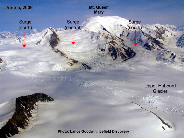
-
Glacier Research
2009-05-05 en Recent Updates
The terminus of Hubbard glacier was significantly advanced this year in comparison to the last three years of measurement and to date continues to show continued activity but slightly back from it's seasonal maximum.
-
Watts Up With That? (Antony Watts)
2015-06-22 en The Hubbard Glacier defies 'climate change' - continues to growHubbard Glacier could permanently dam the entrance to Russell Fiord in as little as 10 years
From NOAA Earth Observatory:
Since measurements began in 1895, Alaska's Hubbard Glacier has been thickening and steadily advancing into Disenchantment Bay.
The advance runs counter to so many thinning and retreating glaciers nearby in Alaska and around the world.
According to Leigh Stearns, a glaciologist at the University of Kansas, Hubbard's advance is due to its large accumulation area; the glacier's catchment basin extends far into the Saint Elias Mountains.
Snow that falls in the basin either melts or flows down to the terminus, causing Hubbard to steadily grow.
In addition, Hubbard is building up a large moraine, shoveling sediment, rock, and other debris from Earth's surface onto the glacier's leading edge.
The moraine at the front gives the glacier stability and allows it to advance more easily because the ice does not need to be as thick to stay grounded. (If it is thin, it can start floating and will not necessarily advance.)
Twice in the past hundred years - in 1986 and again in 2002 - the moraine has made contact with Gilbert Point and blocked the entrance to Russell Fjord. With nowhere to drain, runoff caused the water level in the fjord to rise rapidly.
-
Real Science
2015-09-18 en 75% Of Alaska Stations Have Cooled Since 1977
← 3. Norwegian glaciers. Growing again.
|
|
After years of decline, glaciers in Norway are again growing. |
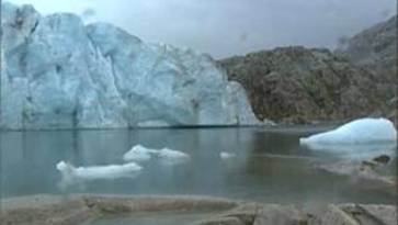
-
Not by Fire but by Ice
2008-11-27 en Glaciers in Norway Growing Again
The actual magnitude of the growth, which appears to have begun over the last two years, has not yet been quantified.
The flow rate of many glaciers has also declined. Glacier flow ultimately acts to reduce accumulation, as the ice moves to lower, warmer elevations.
-
DailyTech
2008-11-27 en Glaciers in Norway Growing AgainAfter years of decline, glaciers in Norway are again growing, reports the Norwegian Water Resources and Energy Directorate (NVE).
The flow rate of many glaciers has also declined. Glacier flow ultimately acts to reduce accumulation, as the ice moves to lower, warmer elevations.
The original trend had been fairly rapid decline since the year 2000.
Despite the recent growth, most glaciers in the nation are still smaller than they were in 1982. However, Elvehøy says that the glaciers were even smaller during the 'Medieval Warm Period' of the Viking Era, prior to around the year 1350.
Not all Norwegian glaciers appear to be affected, most notably those in the Jotenheimen region of Southern Norway.
← 4. Glaciers growing on Canada's tallest mountain
|
|
Canada's tallest mountain, the Yukon's towering Mount Logan, may have experienced a growth spurt. |

-
canada.com
2008-11-17 en Canada's highest peak growing, researcher finds
Canada's highest point -- the ice-covered peak of Yukon's soaring Mount Logan -- may be due for an official re-measurement after an American researcher on a neighbourly flyby took readings that suggest this country's superlative summit has experienced a growth spurt.
← 5. North to Alaska and more growing glaciers
|
|
Alaska's glaciers have been in retreat for nearly 200 years. |

-
MichNews.com
2008-10-28 en Alaska's Glaciers Are GrowingAlaska's glaciers grew this year, after shrinking for most of the last 200 years.
The reason? Global temperatures dropped over the past 18 months.The global mean annual temperature has been declining recently because the solar wind thrown out by the sun has retreated to its smallest extent in at least 50 years. This temperature downturn was not predicted by the global computer models, but had been predicted by the sunspot index since 2000.
The solar wind normally protects the earth from 90 percent of the high-energy cosmic rays that flash constantly through the universe.
Henrik Svensmark at the Danish Space Research Institute has demonstrated that when more cosmic rays hit the earth, they create more of the low, wet clouds that deflect heat back into outer space. Thus the earth's recent cooling.
Unusually large amounts of Alaskan snow last winter were followed by unusually chilly temperatures there this summer.
"In general, the weather this summer was the worst I have seen in at least 20 years," says Bruce Molnia of the U.S. Geological Survey, and author of The Glaciers of Alaska.
"It's been a long time on most glaciers where they've actually had positive mass balance (added thickness)."
Overall, Molnia figures Alaska had lost 10-12,000 square kilometers of ice since 1800, the depths of the Little Ice Age.
That's enough ice to cover the state of Connecticut.
Climate alarmists claim all the glaciers might disappear soon, but they haven't looked at the long-term evidence of the 1,500-year Dansgaard-Oeschger climate cycles. During the Little Ice Age-1400 to 1850-Muir Glacier filled the whole of Glacier Bay.
Since then, the glacier has retreated 57 miles.
But the Little Ice Age was preceded by the Medieval Warming, the cold Dark Ages, a Roman Warming, and a whole series of moderate warmings and coolings that extend back at least 1 million years based on the evidence of the microfossils in the world's seabed sediments.
The sunspots are now predicting a 30-year cooling of the earth. That would thicken the Alaskan glaciers somewhat, but probably wouldn't refill Glacier Bay with ice. That'll have to wait for the next icy age.
The sunspot index has a 59 percent correlation with our temperatures (with a roughly ten-year lag). CO2 has only an "accidental" 22 percent correlation with our temperatures, which should be grounds for dismissing CO2 as a major climate player.
All this is radically different from the 5-degree C warming predicted by the computer models.
However, the scientific rule says: if actual observations tell you something that's the opposite of your theory, change your theory.
-
DailyTech
2008-10-16 en Alaskan Glaciers Grow for First Time in 250 yearsA bitterly cold Alaskan summer has had surprising results. For the first time in the area's recorded history, area glaciers have begun to expand, rather than shrink.
Summer temperatures, which were some 3 degrees below average, allowed record levels of winter snow to remain much longer, leading to the increase in glacial mass.
"In mid-June, I was surprised to see snow still at sea level in Prince William Sound", said glaciologist Bruce Molnia. "In general, the weather this summer was the worst I have seen in at least 20 years".
"On the Juneau Icefield, there was still 20 feet of new snow on the surface [in] late July. At Bering Glacier, a landslide I am studying [did] not become snow free until early August."
Molnia, who works for the US Geological Survey, said it's been a "long time" since area glaciers have seen a positive mass balance - an increase in the total amount of ice they contain.
Since 1946, the USGS has maintained a research project measuring the state of Alaskan glaciers. This year saw records broken for most snow buildup. It was also the first time since any records began being that the glaciers did not shrink during the summer months.
Those records date from the mid 1700s, when the region was first visited by Russian explorers. Molnia estimates that Alaskan glaciers have lost about 15% of their total area since that time -- an area the size of Connecticut.
One of the largest areas of shrinkage has been at the national park of Glacier Bay. When Alexei Ilich Chirikof first arrived in 1741, the bay didn't exist at all - only a solid wall of ice. From that time until the early 1900s, the ice retreated some 50 miles, to form the bay and surrounding area.
Accordingly to Molnia, a difference of just 3 or 4 degrees is enough to shift the mass balance of glaciers from rapid shrinkage to rapid growth. From the 1600s to the 1900s, that's just the amount of warming that was seen, as the planet exited the Little Ice Age.
Molnia says one cold summer doesn't mean the start of a new climatic trend. At least years like this, however, might mark the beginning of another Little Ice Age.
← 6. Glaciers are growing in California. California?
|
|
You might be surprised to learn that the Golden State has glaciers. |

-
Fox News
2008-07-09 en Mysterious California Glaciers Keep Growing Despite Warming
Global warming is shrinking glaciers all over the world, but the seven tongues of ice creeping down Mount Shasta's flanks are a rare exception: They are the only known glaciers in the continental U.S. that are growing.
← 7. A glacier is growing on Washington's Mt. St. Helens.
|
|
Mount Saint Helens has glaciers? But it's an active volcano. |

|
|
|
In the winter and early spring, snow tumbles down avalanche chutes on the crater walls. Notes cave entrance in front of picture. |

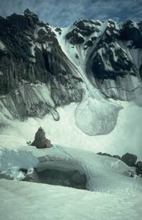
-
Glacier Caves (Charlie Anderson Jr.)
2000-12-15 en The beginning of a New Glacier Forming in the Crater of Mount St. Helens.
Snow Accumulation in the Crater of Mount St. Helens.On Mount St. Helens, we have had a unique opportunity to study the interaction of geothermal energy with the accumulation of alpine snowpack from its inception after a major eruption.
We began investigative work in the crater in 1981 (Anderson and others,2000).
Yearly surveys began in 1982 with mapping, description, and photography of cave passages, snow, firn, and ice. This investigation involved reconnaissance mapping and sampling from 1981 through 2000 by members of the International Glaciospeleological Survey (IGS) with the permission of the U.S. Forest Service and Mount St. Helens National Volcanic Monument.
Over the last 20 years snow, ice and rock debris have average in excess of 325 feet thick have and in places there are 450 to 600 feet deep, that have accumulated behind the lava dome.
A new glacier is now forming in the crater of Mount St. Helens.
A permanent body of ice has accumulated in the crater. IGS Crater Team Scientists FIND THE START OF A NEW GLACIER crater Leader Charles H. Anderson Jr. in 1999.
-
KATU COM
2008-05-14 en Against odds, glacier grows in cauldron of Mt. St. Helens"On May 18, 1980, the once bucolic ice-cream cone shape that defined Mount St. Helens in Washington state disappeared in monstrous blast of ash, rock, gas, and heat.
"Inside the volcano, which was once a soft dome of snow but is now a gaping, steaming menace with an unpredictable streak, an unexpected phenomenon is taking place: a glacier is growing.
"In these days of global warming concerns and scientists showing alarming then-and-now images of glaciers disappearing from mountainsides, it may be the only growing glacier in America - or maybe the world.
← 8. Glaciers are growing in France and Switzerland, too
|
|
Another continent has reported in. According to an article in the Journal of Geophysical Research, glaciers are growing in France and Switzerland, to |

|
|
|
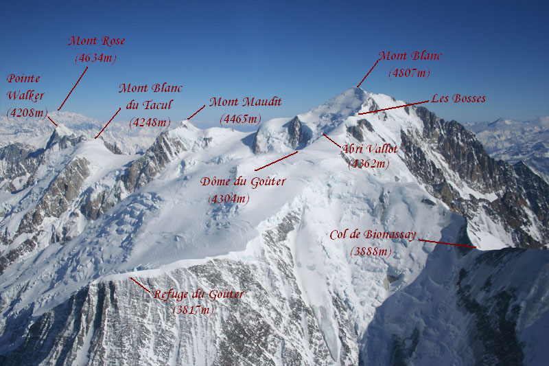
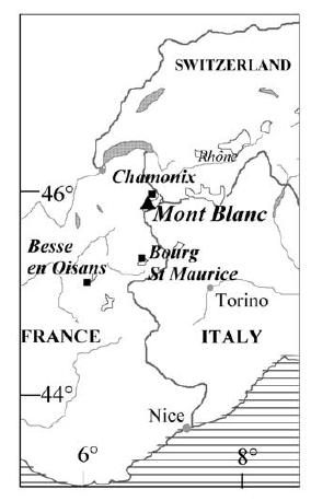
|
|
|


-
World Climate Report
2007-06-26 en Mont Blanc Glaciers Refuse to Shrink? -
If you have an interest in global warming and its effect on mountain glaciers, you will be thrilled to know that there are over one million websites on the subject.
Even before you get to the first site, you already know what you will find.
Burning fossil fuels increases atmospheric concentrations of greenhouse gases, the Earth is warming, mountain glaciers are in full retreat all over the planet, delicate ecosystems are in peril, and humans who rely on the freshwater from mountain glaciers better get creative fast.
Recall that in the Gore film, a great deal of attention was paid to the diminishing "snows of Kilimanjaro" - Gore has made hay in Glacier National Park as well pointing to shrinking glaciers.
Retreating mountain glaciers have become a poster-child of the global warming alarmists - no presentation on the subject is complete without one.
-
The Intergovernmental Panel on Climate Change (IPCC) says in their recent 2007 Summary for Policymakers "Mountain glaciers and snow cover have declined on average in both hemispheres.
Widespread decreases in glaciers and ice caps have contributed to sea level rise."
Someone in Europe missed the memo on this subject as a recent article has appeared in the Journal of Geophysical Research entitled "Very high-elevation Mont Blanc glaciated areas not affected by the 20th century climate change."
To say the least, we at World Climate Report were interested in what the authors had to say.
-
The research was conducted by six scientists from leading agencies and departments in France and Switzerland that deal with hydrology and glaciology.
Before you see the title of the article and immediately suspect some conspiracy funded by European coal companies, be aware that the research was funded by Observatoire des Sciences de l'Univers de Grenoble (OSUG), the European Programs ALPCLIM and CARBOSOL, and by the city of Chamonix Mont-Blanc.
Given the title of the article, we wonder if the six scientists will ever be funded again by any European agencies.
Mont Blanc is located on the border of Switzerland and France, and the summit of Mont Blanc is clearly visible from the United Nations complex in Geneva - the home of countless meetings of the IPCC and other international agencies addressing the climate change issue.
How ironic - based on the title of the article, we doubt the research will be prominently featured in any upcoming IPCC meeting in Geneva?
Vincent et al. state "The most striking features of these figures are the small thickness changes observed over the 20th century.
For both areas, thickness variations do not exceed ±15 m. The average changes are +2.6 m at Dôme du Goûter (please note that this glacier is growing) and -0.3 m (-12 inches) at Mont Blanc.
-
Considering the uncertainty interval, i.e., ±5 m, it can be concluded that no significant thickness change is detectable over most of these areas.
All these results suggest that the SMB at Dôme du Goûter and Mont Blanc did not experience any significant changes over the 20th century.
-
Not by Fire but by Ice
2007-10-15 en Mont Blanc glacier almost doubles in size in four years"The volume of ice on Mont Blanc's slopes over 4800 metres high was first calculated at 14,600 cubic metres in 2003.
It dropped to 14,300 cubic metres two years later, but then almost doubled to 24,100 cubic metres in 2007.
← 9. New Zealand's largest glaciers are growing
|
|
Growing may not be a strong enough word. They're surging. |
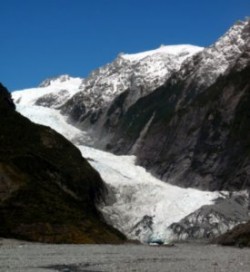
-
Not by Fire but by Ice
2007-01-31 en Fox, Franz Josef glaciers defy trend New Zealand's two best-known glaciers still on the march
Guides say the Franz Josef and the Fox glaciers continued advancing down their valleys in the past year and may soon be close to positions reached 40 years ago.
← 10. Russia's glaciers are growing, too
|
|
The Russians don't believe the IPCC forecasts, but they do believe their own eyes. |
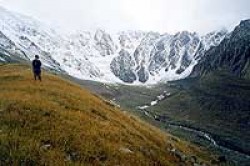
-
Not by Fire but by Ice
2002-09-20 en Glaciers are growing around the world, including the United StatesRussian glaciers surging - On September 20, 2002, a huge 22-million ton piece of the gigantic Maili Glacier broke loose and crashed down a steep gorge into the village of Kami killing more than 150 people and injuring hundreds more.
The 500-foot wall of ice had been growing for six years.
The Maili Glacier is just one of several glaciers in the North Caucasus Mountains that have been EXPANDING at an alarming rate.
Other towns in the region have been partially buried by these advancing walls of ice.
One local scientist in southern Russia said, "we may be seeing the beginning of a new great ice age!!!"
-
Earth Observatory
2005-04-24 en On September 20, 2002, the Kolka Glacier in the Caucasus Mountains collapsed under the slopes of Mt. Dzhimarai-khokh.
← 11. Argentina's Perito Moreno glacier is, you guessed it, growing
|
|
Is there a continent where glaciers aren't growing? If so, South America isn't one of them. Consider Argentina's Perito Moreno glacier. |

-
Not by Fire but by Ice
2009-06-15 en Largest glacier in Argentina advancing"Nourished by Andean snowmelt, the glacier constantly grows even as it spawns icebergs the size of apartment buildings into a frigid lake, maintaining a nearly perfect equilibrium since measurements began more than a century ago."
Perito Moreno, a vast, 19-mile-long (30km) and 3-mile-wide (5 km) river of ice, is the largest glacier in Patagonia.
-
msnbc.com
2009-06-15 en Argentine glacier advances despite warmingArgentina's Perito Moreno glacier is one of only a few ice fields worldwide that have withstood rising global temperatures.
Nourished by Andean snowmelt, the glacier constantly grows even as it spawns icebergs the size of apartment buildings into a frigid lake, maintaining a nearly perfect equilibrium since measurements began more than a century ago.
"We're not sure why this happens," said Andres Rivera, a glacialist with the Center for Scientific Studies in Valdivia, Chile. "But not all glaciers respond equally to climate change."
-
Gilbert Ashoff
2007-0-22 en Gore's glacial lieAn interesting footnote and one of the major lies in the movie "An Inconvenient Truth" is that Mr. Gore and Co. show the Perito Moreno Glacier in So. Argentina as an example of the result of global warming.
In fact my wife Marjorie and I have visited this glacier 3 times. First in 1973 and again in 2004 and 2006.
It is growing. It is visibly larger and pushing further across Lago Argentina.
They used this in the movie twice all the while misrepresenting its growth and in fact stating it is shrinking showing a huge chunk falling off as it does every 30 minutes or so. It is a dramatic glacier that yields tremendous photo ops to just about anyone who visits it, which I must presume is why it was used.
-
Google Images Search
2007-0-22 en perito moreno
← 12. Iceland's Breidamerkurjokull glacier. Yup, it's growing, too.
The Daily Mail UK ran a story on July 31, 2009 about the horrors of global warming. It was accompanied, for some inexplicable reason, by contradictory photos that showed the remarkable growth of Iceland's Breidamerkurjokull glacier.
Their headline screamed, "How global warming is changing the face of the northern hemisphere."
The photos and caption told a story that was, you'll pardon the expression, the polar opposite of what the article described.
|
|
|
|
|
Chilling reminder: An aerial view shows huge ice towers and crevasses on the glacier. "The drastic alterations have been blamed on greenhouses gases." |
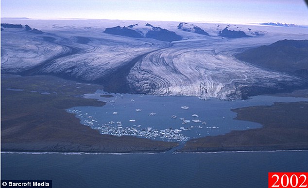
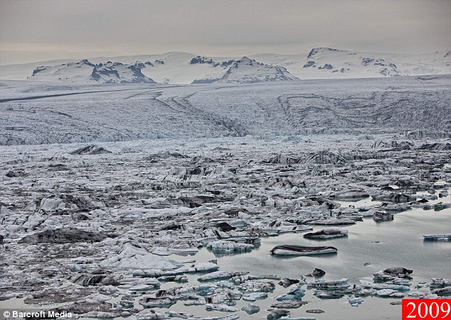

-
Mail Online
2009-07-31 en In pictures: How global warming is changing the face of the northern hemisphereSlowly but surely the Breidamerkurjokull glacier is melting away.
This 60 mile long expanse of ice has edged from the mountains into a lagoon and over the past 30 years has shown no sign of moving back.
Over this time professional photographer Ragnar Sigurdsson has been documenting the alarming phenomenon that has been taking place.
In the past, the beautiful lagoon remained unfrozen even in winter except for the occasional drifting iceberg. But now, as these aerial images show, it appears like a solid mass even in the summer.
'It is perfectly natural for a glacier to move. They tend to recede or advance in cycles but this time the tongue of the Breidamerkurjokull has come all the way down into the lagoon.'
The disturbing changes pose little threat to structures or human life, with the nearest town over 60 miles away. But the rapid influx of ice is seen as a chilling reminder that greenhouses gases are altering the planet.
Ragnar, 51, from Reykjavik, said: 'There is no threat of a disaster. The rate that the water rises, it would take more than 50 years for it to take the bridge but people in the area still feel it's global warming that's doing it.
'The end result is this extra freshwater is pouring into the sea at an alarming rate.'
Despite the beautiful appearance of the contrast in water types, the pictures will worry environmentalists across the world.
← 13. Glaciers Growing In Northern Greenland
-
Real Science
2015-09-18 en Glaciers Growing In Northern Greenland
↑
Gletscher im Himalaya
en Himalaya Glaciers
fr Glaciers au Himalaya
|
|

↑ de Gletscher im Himalaya
|
|
de Veränderungen zwischen 2000-2010 von mehr als zweitausend per Satellit vermessenen Himalayagletschern.
Grün: stabil, Die Gletscher im Karakorum haben in den letzten drei Jahrzehnten an Masse zugelegt, nicht etwa verloren. en Number of glaciers showing retreat, advance or stability during 2000-01/02 to 2010-11. |

-
Die kalte Sonne (Fritz Vahrenholt & Sebastian Lüning)
2014-11-17 de Himalayagletscher verweigern IPCC-Schmelzbefehl.
Tibetgletscher erlitten in den letzten 4000 Jahren gleich vier Schmelzphasen im Takte der SonnenaktivitäteDie Erde hat sich in den letzten anderthalb Jahrhunderten um fast ein Grad erwärmt.
Dieser Temperaturanstieg im Anschluss an die Kleine Eiszeit hat sich auch in den Gletschern des Himalayas bemerkbar gemacht.Die Gletscherschmelze im höchsten Gebirge kommt nicht überraschend. Auch vor 1000 Jahren zur Zeit der Mittelalterlichen Wärmeperiode schrumpften die langen Eiszungen im Himalaya. In der darauffolgenden Kleinen Eiszeit einige hundert Jahre später dehnten sie sich dann wieder aus.
Eine beeindruckende Zyklik.
Die Tibetgletscher wuchsen und schrumpften im Tausendjahrestakt, Schmelzphasen ähnlich jener im 20. Jahrhundert ereigneten sich während der Mittelalterlichen Wärmeperiode vor 1000 Jahren, der Römischen Wärmperiode vor 2000 Jahren und der Minoischen Wärmeperiode vor 3000 Jahren.
Übereinstimmung mit der Klimazyklik im Nordatlantik
Den Antrieb der Klimaschwankungen erkannten Bond et al. in Änderungen der Sonnenaktivität.
Zurück in die Heutezeit.
Interessant bei all dem klimatischen Mediengetöse ist, dass die Gletscherschmelze im Himalaya seit etwa einem Jahrzehnt stagniert.
Mithilfe von Satellitenbildern untersuchten die Forscher mehr als zweitausend Einzelgletscher aus der Region und fanden, dass sich die Eismasse zwischen 2000 und 2010 nur um vernachlässigbare 0,2% verringert hatte.
Die Wissenschaftler schlussfolgerten, dass sich der Großteil der Himalaya-Gletscher in einem gesunden Gleichgewicht ("steady state") befinden.
Und was steuert den Monsun?
Offenbar hat unsere liebe Sonne hier ihre Finger mit im Spiel.
Noch am 23. April 2014 malten Claus Kleber und Arte den Teufel an die Wand
China und Indien kämpfen im Himalaya um Wasser. Die lebensnotwendige Ressource wird aufgrund des Klimawandels unberechenbar. Das wirkt sich schon jetzt auf das Leben vieler Menschen in den Bergan aus. Der renommierte Fernsehjournalist Claus Kleber erklärt, wie der Konflikt gelöst werden kann.
Da ist wohl was schiefgelaufen, Herr Kleber. Werden Sie Ihre Zuschauer über die Panne entsprechend informieren? Vermutlich nicht.
-
Klimaskeptiker Info
2009-08-27 de Gletscher haben schon weit wärmere Phasen überstandenForscher der Brigham Young Universität (BYU) haben die Geschichte etlicher Gletscher im Himalaya untersucht.
In der Erwärmungsphase vor 9000 Jahren haben sich viele Gletscher zurückgezogen (was nach dem Ende der Eiszeit eine natürliche und lang anhaltende Entwicklung darstellte).
Einige Gletscher im Südwest-Himalaya sind aber genau in dieser Periode von einem auf sechs Kilometer angewachsen.
Für die Zunahme der Eismassen kommen stärkere Monson-Niederschläge und eine Veränderung lokaler und regionaler Wettermuster in Frage.
-
Klimaskeptiker Info
2010-01-17 de Pachauris Irreführung der ganzen Welt über das Schmelzen der Himalaya-GletscherRajendra Pachauri, der in letzter Zeit wegen seiner Verflechtungen mit der indischen Energiewirtschaft ins Schußfeld geratene Chef des IPCC, des sogenannten "Weltklimarats" der Vereinten Nationen (UN), hat vor ein paar Wochen die indische Regierung der Arroganz beschuldigt, weil diese das von seinem IPCC prophezeite Verschwinden der Himalaya-Gletscher bis 2035 für unwahrscheinlich hält und vor allem keinen Zusammenhang mit der vermeintlichen anthropogenen Erwärmung (AGW) anerkennt.
-
Klimaskeptiker Info
2010-01-23 de NASA rudert zurück: Zitat der falschen Himalaya-Gletscher-Prognose verschwundenWenn Sie auf der Klimawandel-Internet-Seite der NASA nach unten rollen, finden Sie einen Eintrag, der das Abschmelzen von Gletschern behandelt. Noch vor vier Tagen sah dieser Eintrag anders aus.
-
Klimaskeptiker Info
2011-01-27 de Studie: Himalaya-Gletscher schmelzen nicht wegen KlimawandelsHimalaya-Gletscher sind momentan auf dem Vormarsch statt auf dem Rückzug, sagt die erste große Studie nach der Veröffentlichung der falschen Prognose im (nobelpreisgekrönten!) 4. IPCC-Bericht 2007, nach der die Gletscher bis 2035 verschwinden sollten.
Forscher haben herausgefunden, daß entgegen einer weitverbreiteten Annahme die Hälfte der Gletscher im Karakorum-Gebiet momentan wachsen statt zu schrumpfen.
↑ en Himalayan glaciers
-
Whats Up With That? (Antony Watts)
2009-08-29 en Study: Glaciers defied hotter temperatures 9000 years ago
-
Brigham Young University
2009-08-27 en BYU geologist solves mystery of glaciers that grew while Asia heated up9,000 years ago. While most other Central Asian glaciers retreated under hotter summer temperatures, this group of glaciers advanced from one to six kilometers.
"Stronger monsoons were thought to be responsible,"
"Our research indicates the extra snowfall from monsoonal effects can only take credit for up to 30 percent of the glacial advance."
As Central Asia's summer climate warmed as much as 6 degrees Celsius, shifting weather patterns brought more clouds to the Southeast Himalayas. The additional shade created a pocket of cooler temperatures.
Temperatures also dropped when higher winds spurred more evaporation in this typically humid area, the same process behind household swamp coolers.
The story of these seemingly anomalous glaciers underscores the important distinction between the terms "climate change" and "global warming."
-
Watts Up With That? (Antony Watts)
2009-11-11 en Pachauri claims Indian scientific position "arrogant"
IPCC chairman Rajendra Pachauri accuses Indian environment ministry of 'arrogance' for its report claiming there is no evidence that climate change has shrunk Himalayan glaciers - 2010-01-17 en Told ya so... IPCC to retract claim on Himalayan Glacier Melt - Pachauri's "arrogance" claim backfires
-
Whats Up With That? (Antony Watts)
2010-02-03 en Lawrence Berkeley National Labs (LBNL) on Himalayas: "greenhouse gases alone are not nearly enough to be responsible for the snow melt"
-
Times Online
2010-01-17 en World misled over Himalayan glacier meltdownIPCC chairman Rajendra Pachauri accuses Indian environment ministry of A WARNING that climate change will melt most of the Himalayan glaciers by 2035 is likely to be retracted after a series of scientific blunders by the United Nations body that issued it.
Two years ago the Intergovernmental Panel on Climate Change (IPCC) issued a benchmark report that was claimed to incorporate the latest and most detailed research into the impact of global warming. A central claim was the world's glaciers were melting so fast that those in the Himalayas could vanish by 2035.
In the past few days the scientists behind the warning have admitted that it was based on a news story in the New Scientist, a popular science journal, published eight years before the IPCC's 2007 report.
It has also emerged that the New Scientist report was itself based on a short telephone interview with Syed Hasnain, a little-known Indian scientist then based at Jawaharlal Nehru University in Delhi.
Hasnain has since admitted that the claim was "speculation" and was not supported by any formal research. If confirmed it would be one of the most serious failures yet seen in climate research. The IPCC was set up precisely to ensure that world leaders had the best possible scientific advice on climate change
-
Watts Up With That? (Antony Watts)
2011-01-27 en New science on Himalayan glaciers shows debris fields to be a regulating factor in meltingHimalayan glaciers not melting because of climate change, report finds
Himalayan glaciers are actually advancing rather than retreating, claims the first major study since a controversial UN report said they would be melted within quarter of a century.
Researchers have discovered that contrary to popular belief half of the ice flows in the Karakoram range of the mountains are actually growing rather than shrinking.
Quelle / Source:
-
Telegraph / Christopher Booker
2011-01-27 en Himalayan glaciers not melting because of climate change, report finds
↑ fr Himalaya glaciers
-
20 Minutes
2010-01-20 fr Fonte des glaciers de l'Himalaya: le GIEC reconnaît son erreur mais défend la tendanceEn 2007, dans son 4è rapport, qui lui avait valu le Prix Nobel de la Paix, le GIEC avait estimé que les glaciers de l'Himalaya reculaient plus vite que les autres du monde et «pourraient disparaître d'ici 2035, voire avant».
Rajendra Pachauri, le chef du groupe, a déclaré à la presse à Abou Dhabi en marge d'un sommet sur les énergies du futur, que même si cette prévision était erronée, il n'en demeure pas moins que le changement climatique est réel.
↑ HimalayaGate
|
Glacier scientist: I knew data hadn't been verified 'It related to several countries in this region and their water sources. We thought that if we can highlight it, it will impact policy-makers and politicians and encourage them to take some concrete action. |
Rajendra Pachauri was told that the Intergovernmental Panel on Climate Change assessment that the glaciers would disappear by 2035 was wrong, but he waited two months to correct it. The IPCC's shock prediction in its 2007 report that the likelihood of the glaciers "disappearing by the year 2035 and perhaps sooner is very high" thus had huge impact in India and other Asian countries, and it is precisely this statement that the IPCC has now been forced to disown. |


-
2010-01-24 en
Richard North: Pachauri must resign
British writer Richard North says Pachauri will resign or will be forced to.
-
2010-01-29 en
Himalayan Controversy
NDTV report that scientists have found that the Himalayan Glaciers are actually expanding, in direct contradiction to the doomsday forecast by the IPCC
-
Climategate
2010-01-30 en
Dr. Rajendra Pachauri is a liar, and now he's busted
Rajendra Pachauri was told that the Intergovernmental Panel on Climate Change assessment that the glaciers would disappear by 2035 was wrong, but he waited two months to correct it.
He failed to act despite learning that the claim had been refuted by several leading glaciologists.
Dr Pachauri, who played a leading role at the summit, corrected the error last week after coming under media pressure.
He told The Times on January 22 that he had only known about the error for a few days. He said: "I became aware of this when it was reported in the media about ten days ago. Before that, it was really not made known. Nobody brought it to my attention.
However, a prominent science journalist said that he had asked Dr Pachauri about the 2035 error last November. Pallava Bagla, who writes for Science journal, said he had asked Dr Pachauri about the error.
He said that Dr Pachauri had replied: "I don't have anything to add on glaciers."
-
2010-01-22 en
'Glacier-gate'
The Intergovernmental Panel on Climate Change says a report on the Himalayan glaciers contained errors.
![]()
![]() en
NASA's Mistaken Glacier Info
(Donna Laframboise 2010-01-25)
en
NASA's Mistaken Glacier Info
(Donna Laframboise 2010-01-25)
Mountain glaciers and snow cover have declined on average in both
hemispheres, and may disappear altogether in certain regions of our
planet, such as the Himalayas, by 2030

de
-
Klimaskeptiker Info
2010-01-24 de Pachauri muß zurücktreten - seine Position ist unhaltbarWeder in den USA noch in Europa kann man sich leicht vorstellen, welcher Sturm um Pachauris GlacierGate in Indien losgebrochen ist.
Der Skandal sorgt in Indien für Schlagzeilen und die Leute sind wirklich ärgerlich auf Pachauri, weil er sie glauben gemacht hatte, ihre Wasserversorgung sei in relativ naher Zukunft (2035) wegen des vermeintlichen Verschwindens der Himalaya-Gletscher in ernster Gefahr, während sie jetzt erfahren mußten, daß Pachauris Kollege zugibt, daß die Prognose für 2035 falsch war, aber benutzt wurde, um die Politik zu Aktivitäten zu drängen.
Dr. Richard North, der zusammen mit Christoph Booker vom Telegraph den Artikel verfaßt hat, der den GlacierGate-Skandal zuerst enthüllte, sagte jetzt in einem Interview im indischen Fernsehen: "Wenn Pachauri nicht freiwillig zurücktritt, wird er zum Rücktritt gezwungen werden".
2010-01-29 de Die Schlinge zieht sich zu: Pachauri wußte schon seit zwei Monaten von der falschen Himalaya-Gletscher-Prognose
Der Chef des IPCC, Eisenbahningenieur Rajendra Pachauri, hat weiterhin schlechte Presse. Die Times beschuldigt ihn jetzt der direkten Lüge.
2010-02-04 de Indien droht sich aus dem IPCC zurückzuziehen
2010-03-09 de Direktor des Wadia-Insituts: Globale Erwärmung hat keinen Einfluß auf den Himalaya
en
-
Watts Up With That? (Antony Watts)
2010-01-23 en BREAKING NEWS: scientist admits IPCC used fake data to pressure policy makersMail Online:
Glacier scientist: I knew data hadn't been verified
'It related to several countries in this region and their water sources.
We thought that if we can highlight it, it will impact policy-makers and politicians and encourage them to take some concrete action.2010-01-24 en "Pachauri must resign - his position is untenable"
Here in the USA, WUWT readers probably don't have a true handle on the firestorm that is going on in India over Pachauri's "glaciergate".
It is making headlines and the people there are quite angry, because they've been led to believe that their Himalayan water supply was seriously threatened in the not too distant future (2035) as reported in the IPCC AR4, and now they find out it's a bogus, and that a Pachauri peer now specifically admits the 2035 date was known to be false, and used anyway to scare policymakers into action.
-
Telegraph / Christopher Booker
2010-01-24 en Pachauri: the real story behind the Glaciergate scandalDr Pachauri has rapidly distanced himself from the IPCC's baseless claim about vanishing glaciers. But the scientist who made the claim now works for Pachauri.
... What has now come to light, however, is that the scientist from whom this claim originated, Dr Syed Hasnain, has for the past two years been working as a senior employee of The Energy and Resources Institute (TERI), the Delhi-based company of which Dr Pachauri is director-general. Furthermore, the claim - now disowned by Dr Pachauri as chairman of the IPCC - has helped TERI to win a substantial share of a $500,000 grant from one of America's leading charities, along with a share in a three million euro research study funded by the EU.
To understand why the future of Himalayan glaciers should arouse such peculiar passion, one must recall why they have long been a central icon in global warming campaigners' propaganda.
Everything that polar bears have been to the West, the ice of the Himalayas has been - and more - to the East.
This is because, as Mr Gore emphasised in his Oscar-winning film An Inconvenient Truth, the vast Himalayan ice sheet feeds seven of the world's major river systems, thus helping to provide water to 40 per cent of the world's population.
The IPCC's shock prediction in its 2007 report that the likelihood of the glaciers "disappearing by the year 2035 and perhaps sooner is very high" thus had huge impact in India and other Asian countries, and it is precisely this statement that the IPCC has now been forced to disown.
2010-02-04 en India forms new climate change body
The Indian government has established its own body to monitor the effects of global warming because it "cannot rely" on the United Nations' Intergovernmental Panel on Climate Change, the group headed by its own Nobel prize-winning scientist Dr R.K Pachauri.
-
Times Online
2010-01-30 en Climate chief was told of false glacier claims before CopenhagenThe chairman of the leading climate change watchdog was informed that claims about melting Himalayan glaciers were false before the Copenhagen summit, The Times has learnt.
Rajendra Pachauri was told that the Intergovernmental Panel on Climate Change assessment that the glaciers would disappear by 2035 was wrong, but he waited two months to correct it.
He failed to act despite learning that the claim had been refuted by several leading glaciologists.
-
Thaindian News
2010-02-04 en India to have own panel on climate change: Jairam RameshIndia would soon have its very own panel on climate change, union Environment Minister Jairam Ramesh announced Thursday and added that the country could not depend only on reports from the UN Intergovernmental Panel on Climate Change (IPCC).
Stressing that the IPCC's weakness was that it didn't do original research and derives assessments from published literature, the minister announced a climate change panel for India.
-
Hindustan Times
2010-03-06 en Global Warming has no impact on Himalayas claims Wadia Director
fr
-
Pensée Unique (Jean Martin)
2010-01-03 fr Un Glaciergate ? : Les glaciers de l'Himalaya, la presse, le rapport AR4 du GIEC, le WWF, R. Pachauri et les glaciologues...IPCC AR4 WG2 Ch10, p. 493
"Glaciers in the Himalaya are receding faster than in any other part of the world (see Table 10.9) and, if the present rate continues, the likelihood of them disappearing by the year 2035 and perhaps sooner is very high if the Earth keeps warming at the current rate.
Its total area will likely shrink from the present 500,000 to 100,000 km2 by the year 2035 (WWF, 2005)".
Extrait du rapport du GIEC 2007, Groupe de travail N°2, Chapitre 10, page 493.
"Les glaciers de l'Himalaya sont en recul plus rapide que dans n'importe quelle autre partie du monde (voir Table 10.9) et, si le taux [NDT : de fonte] continue à son rythme actuel, la probabilité qu'ils disparaissent en 2035 et peut-être plus tôt, est très grande si la Terre continue à se réchauffer au rythme actuel.
Sa surface totale passera probablement de 500.000 km2 à 100.000 km2 en l'an 2035 (WWF, 2005)."
-
ContrePoints
2010-01-25 fr Nouveaux doutes sur le rapport du GIECLe Sunday Times révèle de nouvelles insuffisances du document, présenté pourtant comme la somme de la connaissance scientifique sur le changement climatique. Une nouvelle erreur qui instille plus encore le doute sur la qualité générale du rapport et l'objectivité de ses auteurs.
hier une autre erreur importante du rapport du GIEC, erreur qui fait scandale après le premier mea culpa que l'organisme avait du faire sur les glaciers de l'Himalaya dont il prévoyait la fonte dès 2035, sur la base de documents de presse d'une ONG environnementaliste.
En effet, dans la partie concernant les conséquences du réchauffement climatique sur les catastrophes naturelles et leur aggravation, les prévisions les plus alarmistes n'étaient fondées que sur des documents non publiés et non soumis à une relecture par les pairs, canon du travail scientifique contemporain.
↑ Alpengletscher
de Verzeichnis en Contents fr Sommaire
- 2019
- de
Gletschermanns Entdeckung
Alex Baur (Weltwoche)Der Berner Geologe Christian Schlüchter kennt die Geschichte der Gletscher wie kein anderer.
Doch seine Forschung kam den Prognosen des weltberühmten Professorenkollegen Thomas Stocker in die Quere.
- 2018
- de Neue Erkenntnisse über die fehlende anthropogene Ursache der Alpen-Gletscherschmelze in einer Fachveröffentlichung des Schweizer Paul Scherrer Instituts
- 2015
- de Ruß wärmt stärker als gedacht und ließ Alpengletscher im 19. Jahrhundert tauen
- 2014
- de Neue Studien bestätigen: Alpengletscher hatten bereits zur Zeit der Römischen und Mittelalterlichen Wärmeperioden "Fieber"
- de Berner Geologe Christian Schlüchter: Alpengletscher endeten zu Zeiten Hannibals 300 Höhenmeter über dem heutigen Niveau
- 2013
- de Eine unbequeme Wahrheit: Alpengletscher waren in der Vergangenheit kürzer als heute
- 2010
- de
Gletscherforschung: Die Zeugen früheren Klimawandels
Alex Reichmuth (Weltwoche)Wanner bezeichnet Schlüchters Methode zwar als «spannend».
Trotzdem lässt er durchblicken, dass er nicht viel davon hält:
- 1984
- de Rekonstruktion von Gletscherschwankungen mit Hilfe fossiler Hölzer
de Text en Text fr Texte
⇧ 2019
↑ Gletschermanns Entdeckung
-
Die Weltwoche / Alex Baur
2019-07-10 de Gletschermanns EntdeckungDer Berner Geologe Christian Schlüchter kennt die Geschichte der Gletscher wie kein anderer.
Doch seine Forschung kam den Prognosen des weltberühmten Professorenkollegen Thomas Stocker in die Quere.
Er sei Geologe, sagt Christian Schlüchter zur Begrüssung, «stellen Sie mich um Himmels willen nicht als Gletscherforscher vor».
Die Glaziologen bekämen sonst Wallungen.
Schlüchter wurde zwar weit über die Landesgrenzen hinaus bekannt wegen seiner Erkenntnisse über die Geschichte der Gletscher.
Doch diese waren an sich bloss ein Nebenprodukt seiner geologischen Forschungen.
Welch ein Affront für die Gletscherforscher.
Und als ob das nicht schon genug wäre, fuhr Schlüchter - nolens volens - mit seiner Gletschergeschichte auch noch den Klimaprognostikern in die Parade.
Und mit den Klimakennern ist erst recht nicht zu spassen.
Doch es ist, wie es ist:
Die «verrückte Familiengeschichte» (Schlüchter) der Gletscher
steht quer zu den Klimamodellen von Thomas Stocker,
seinem weltberühmten Professorenkollegen an der Universität Bern.
Unsere Gletscher, so Schlüchters zentrale Erkenntnis,
waren in den letzten 10'000 Jahren die meiste Zeit kleiner als 2005.
Es gab mindestens zwölf Wärmephasen seit der letzten Eiszeit.
Das konnte er aufgrund von Holzstämmen und Torfstücken nachweisen, welche die schmelzenden Eiskolosse freigegeben hatten, oberhalb der heutigen Waldgrenze notabene.
Seine Forschungen zeigen zudem: Die Klimaerwärmung ist kein linearer, sondern ein exponentieller Prozess mit vielen Faktoren, über deren Wechselwirkung wir zu wenig wissen.
Mit dem Wissen kamen die Fragen
Schlüchter hat nie behauptet, der Mensch hätte keinen Einfluss aufs Klima.
Er gehört nicht einmal zu jenen Skeptikern, welche die alarmierenden Prognosen des Weltklimarates (IPCC) für übertrieben halten.
Aus der Sicht der Alarmisten ist es noch schlimmer:
Schlüchter ist ein Agnostiker.
Nach seiner Meinung ist der Mensch weit davon entfernt, die Gründe für die Temperaturschwankungen zu kennen.
Denn je tiefer er in die Geheimsphäre der Gletscher und in die vertrackte Geschichte des Klimas vordrang, desto mehr neue Fragen und Ungereimtheiten kamen zum Vorschein.
Der Kardinalfehler der IPCC-Modelle
besteht nach Schlüchters Ansicht darin, dass man sich auf die menschengemachten Faktoren kapriziert.
Alles andere werde ausgeblendet.
In der real existierenden Welt gibt es aber viele denkbare Faktoren,
die in einer komplizierten Wechselwirkung miteinander stehen.
Klar ist für Schlüchter nur eines:
Wenn man die abrupten Klimaschwankungen und die sie bedingenden Kippeffekte zwischen den Eiszeiten nicht schlüssig erklären kann,
sind Prognosen für die nächsten 50, 100 oder auch 500 Jahre so zuverlässig wie Kaffeesatzlesen.
Und das ist natürlich ein Affront sondergleichen in einer Zeit, in der gemäss landläufiger Doktrin jeder, der an der Unfehlbarkeit des Weltklimarates zweifelt, lächerlich gemacht und in die Schandecke der Leugner verbannt gehört.
Wir treffen Professor Schlüchter in einem abgelegenen Bauernhaus im Berner Emmental oberhalb von Lützelflüh.
Der kräftige, leicht untersetzte und bärtige Mann mit dem stets wachsamen und festen Blick passt perfekt zu diesem Gehöft aus Gotthelfs Zeiten.
Hier wurde er 1947 geboren, hier besuchte er die Grundschulen.
Das Gymnasium absolvierte er in Burgdorf.
1966 ging er nach Bern, um Geologie zu studieren.
Es folgten Studien in Deutschland, später forschte Schlüchter rund um den Erdball.
Doch die Erdung auf der Emmentaler Scholle, hat man den Eindruck, die kam ihm nie abhanden.
«Das Glück war mir hold», fasst Christian Schlüchter sein Leben zusammen, «alles war Zufall und nochmals Zufall.»
Es war ein Zufall, dass just Anfang der 1970er Jahre, als er sein Studium beendet hatte, überall Autobahnen entstanden.
Schneisen wurden in die Landschaft gegraben, Kiesgruben ausgebaggert.
Für einen Geologen war es das Paradies auf Erden:
«Plötzlich konnten wir in die Höger reinschauen.»
Zufälligerweise war es auch die Zeit, als die C14-Methode (Radiokarbondatierung) entwickelt wurde.
Es war ein Meilenstein für die Erkundung der Erdgeschichte.
Und zufälligerweise fand der junge Geologe in Bern hochkarätige Professoren - etwa den Botaniker Max Welten, den Geologen Rolf Rutsch, die Mineralogin Emilie Jäger oder den Physiker Hans Oeschger -, die den Wissbegierigen über alle Schrebergärten hinweg fachübergreifend förderten.
Denn um die geologischen Verschiebungen über die Jahrtausende zu erforschen, reichte ein Spezialgebiet nicht.
Mit der Radiokarbonmethode etwa halfen ihm die Physiker, das Alter von Fundstücken in den Kiesgruben und Moränen zu bestimmen; mit Hilfe der Botaniker wiederum konnte er aufgrund von Pollen oder Hölzern, die er in geologischen Ablagerungen fand, die Vegetation einer bestimmten Epoche ergründen.
Damit konnte man sich ein Bild machen von einem Thema, das damals nur ein paar Aficionados elektrisierte, zufälligerweise aber bald in aller Munde sein sollte: das Klima.
Schlüchter war einer, der sich lieber auf den Schutthalden der Gletscher herumtrieb als in den Bibliotheken und Hörsälen.
Die Arbeiter in den Kiesgruben, von denen er manch einen mit dem Zauber der Geologie infizierte, waren seine treusten Verbündeten.
Bis heute kommt es immer wieder mal vor, dass ihn einer anruft, weil er im Kies auf eine seltsame Formation, einen Findling oder einen vielleicht seit Jahrtausenden eingeschlossenen Baumstamm stösst.
Dieses Holz hatte es Schlüchter schon immer angetan.
Für ihn waren diese Fundstücke gleichsam die Agenden, mit denen er die Geschichte der Veränderungen datieren konnte.
Die Baumarten und Jahrringe waren für ihn wie Wetterstationen.
In unbestechlicher Präzision hatten sie die klimatischen Bedingungen vergangener Epochen aufgezeichnet.
Urban vs. knorrig
Dabei begann alles mit einem gewaltigen Flop.
Mitte der 1970er Jahre fand Schlüchter unter einer Grundmoräne ein Holzstück, dessen Alter im Labor auf 19'500 Jahre datiert wurde.
Es war eine Sensation, weil der Brügel an einem Ort lag, wo er nie hätte liegen dürfen.
Musste man die Geschichte umschreiben?
Nachkontrollen in München ergaben dann aber, dass man sich um Jahrtausende verrechnet hatte.
Das Holzstück war durch organisches Material «verunreinigt», welches aus einer anderen Schicht durchgesickert war.
Es war peinlich, ja, doch sein Ruf nahm keinen Schaden.
Denn Wissenschaft beruhte, damals zumindest noch, auf dem Prinzip von Versuch und Irrtum.
Das war nicht so schlimm, weil die allein seligmachende wissenschaftliche Wahrheit noch nicht erfunden war.
Dumm war nur, wer seine Irrtümer nicht sehen wollte oder vertuschte, statt daraus zu lernen.
Christian Schlüchter wurde 1993 ordentlicher Professor an der Universität Bern.
Das war just die Zeit, als der Umweltphysiker Thomas Stocker am Physikalischen Institut in die Fussstapfen des legendären Hans Oeschger trat.
Stocker hatte sein Handwerk an der ETH Zürich und später an der Columbia University gelernt.
Seine Spezialität waren computergestützte Klimamodelle, die ihn später an die Spitze des Weltklimarates katapultieren sollten.
An der Seite des Klimaaktivisten Al Gore durfte er 2007 im Kollektiv des IPCC den Friedensnobelpreis entgegennehmen.
Die ebenso famosen wie umstrittenen historischen CO2-Kurven von Al Gore waren in Stockers Institut entstanden.
Schlüchter und der zwölf Jahre jüngere Stocker, das sind zwei Welten, die unterschiedlicher kaum sein konnten.
Man muss es sich bildlich vor Augen führen:
Auf der einen Seite der urbane und eloquente Filius der katholischen Zürcher Konditorendynastie Stocker, einer,
der am liebsten im Büro hinter Computern an seinen Modellen werkelte und sich in den internationalen Gremien bewegt wie ein Fisch im Wasser;
auf der anderen Seite der knorrige Bauernbursche aus dem urprotestantischen Emmental,
dem es im Zelt auf den unwirtlichen Gletscherhalden im Himalaja, in der Antarktis, im tiefen Anatolien, in den Alpen oder in den Hochanden am wohlsten ist;
einer, der grundsätzlich allem misstraut, was er nicht mit den eigenen Händen anfassen und mit den eigenen Augen sehen kann.
Jahrelang ergänzten sich die beiden Antipoden ganz leidlich, publizierten sogar zusammen.
Während Stocker beim IPCC die Karriereleiter hochkletterte,
machte Schlüchter in den 1990er Jahren Funde in den Alpen, welche die Geschichte der Gletscher umschreiben sollten.
Und wieder führte der Zufall Regie.
Zwischen 1980 und 1990 waren die meisten Alpengletscher vorübergehend wieder gewachsen.
Seit dem Ende der Kleinen Eiszeit (um 1850) hatte es noch zwei weitere solche Wachstumsphasen gegeben.
Das hatte vor allem mit den Niederschlägen zu tun (der schnellste Gletscherrückgang wurde übrigens im aussergewöhnlich sonnigen Sommer 1947 gemessen).
Entscheidend war:
Der vorübergehende Vorstoss in den 1980er Jahren pflügte die Vorfelder der Gletscher auf und förderte, auch via Schmelzwasserbäche,
massenweise Holz- und Torfstücke zutage,
die vorher während Jahrhunderten oder Jahrtausenden vergraben gewesen und unter hermetischem Verschluss konserviert worden waren.
Zusammen mit seinen Studenten schleppte Schlüchter mehrere tausend Fundstücke aus dem ganzen Alpenraum in die Labors.
So entstand über die Jahre eine detaillierte Geschichte der Gletscher bis zurück in die letzte Eiszeit.
Nicht alle freute das.
Denn die Realität, die der Gletschermann auf dem Feld gefunden hatte, passte immer weniger zu den Klimamodellen des IPCC.
2004 kam es zu einer ersten offenen Kontroverse.
«Hör auf mit diesem Seich», so soll Stocker damals seinen Kollegen im trauten Kreis entnervt beschworen haben.
Wie ernst war das gemeint?
Auf jeden Fall war es nur ein Vorgeschmack auf das, was noch kommen sollte.
Als die Gletscher kleiner waren
Nach der Jahrtausendwende kamen neue Messmethoden auf.
Es konnten nun die Zeiträume bestimmt werden, in denen Gesteinsoberflächen der kosmischen Strahlung ausgesetzt gewesen waren.
Die Felsen, welche die schmelzenden Gletscher freigaben, sprachen wiederum eine klare und deutliche Sprache:
Im frühen Mittelalter oder etwa in der Römerzeit waren die Gletscher viel kleiner als heute, und zwar nicht nur in Europa, sondern weltweit.
In der Öffentlichkeit wurden Schlüchters Forschungen zwar kaum wahrgenommen.
Und er war auch nicht erpicht auf einen Showdown, solange man ihn forschen liess.
Doch an der Universität im mittlerweile zutiefst rot-grünen Bern sorgten die Erkenntnisse des kauzigen Emmentalers, die sich nicht an die offiziellen Modelle hielten, für zunehmende Irritation.
Im Juni 2014 provozierte Christian Schlüchter mit einem ausführlichen Interview in der Zeitung Der Bund einen Eklat.
Schon der vieldeutige Titel («Unsere Gesellschaft ist grundsätzlich unehrlich») versprach Zoff.
Schlüchter legte seine Erkenntnisse sehr detailliert dar.
Zu den Modellen des IPCC äusserte er sich nicht direkt.
Er wies aber darauf hin,
dass sich die zum Teil dramatischen Wärme- und Kältephasen der letzten 12'000 Jahre nicht mit dem CO2 erklären liessen,
dass es viele denkbare Theorien und wenig Gesichertes gebe - und dass man erst das Vergangene begreifen sollte, bevor man die Zukunft prognostiziere.
Es sei schwierig geworden, Forschungsergebnisse zu publizieren, welche der offiziellen Klimadoktrin widersprechen, klagte Schlüchter.
Er plädiere zwar auch für einen schonenden Umgang mit den Ressourcen,
doch mehr Sorgen als das Klima bereite ihm der Zustand der Forschung:
«Viele Naturwissenschafter sind heute Zudiener von Politikern.»
Und weiter:
«Es gibt in der Geschichte viele Beispiele für das Versagen der Naturwissenschaft, weil der Mut gefehlt hat.»
Und zu Professor Stockers Aussage, man habe nur noch die Wahl zwischen zwei und vier Grad Erwärmung, meinte er trocken:
«Die Erfindung des Teufels war die grandioseste Erfindung, die die Menschheit je gemacht hat.
Man kann viel Geld verdienen, wenn man ihn an die Wand malt.»
Bienen und Enkel
Professor Thomas Stocker reagierte mit einer scharfen Replik.
Wenn sein «langjähriger Kollege» mit Holzresten, die er «aus den schmelzenden Gletschern hervorholt», das Weltklima erklären wolle,
dann sei das «weder wissenschaftlich noch seriös».
Es gebe eine «einfache quantitative Erklärung für den weltweit dokumentierten Gletscherschwund:
den vom Menschen verursachten Klimawandel, also den Anstieg der CO2-Konzentration». Und basta.
Stocker warf Schlüchter mangelnde Verantwortung vor,
weil er mit seinen Äusserungen «der Verharmlosung des globalen Klimawandels» Vorschub leiste.
Nach diesem kurzen und heftigen Aufflammen einer Kontroverse wurde es wieder ruhig.
Schon 2012 war der Störfaktor Christian Schlüchter wegpensioniert worden.
Heute kümmert er sich, fidel wie eh und je, vor allem um seine Bienen und seine Enkel.
Mit Schlüchter verschwand einer der letzten Vertreter der alten Garde aus der Universität Bern
und mit ihm die vermaledeiten Baumstämme und Torfstücke, welche die Modelle stören.
Es herrscht Eintracht.
Man fragt sich bloss, wozu denn noch weiter übers Klima geforscht werden soll - wo doch schon alles wissenschaftlich gesichert ist.
|
|
![]() Aletsch-Gletscher im Verlaufe der letzten ca. 3'500 Jahre
Aletsch-Gletscher im Verlaufe der letzten ca. 3'500 Jahre
| de | en | fr |
|---|---|---|
|
Auswirkungen des Klimas Gletscher |
Impacts of Climate Change Glaciers |
Impacts du changement climatique Glaciers |
⇧ 2018
↑ Neue Erkenntnisse über die fehlende anthropogene Ursache der Alpen-Gletscherschmelze in einer Fachveröffentlichung des Schweizer Paul Scherrer Instituts
-
EIKE Europäisches Institut für Klima und Energie
Prof. Dr. Horst-Joachim Lüdecke
2018-10-28 de Neue Erkenntnisse über die fehlende anthropogene Ursache der Alpen-Gletscherschmelze in einer Fachveröffentlichung des Schweizer Paul Scherrer InstitutsDas Schmelzen der Alpengletscher seit Mitte des 19. Jahrhunderts wird oft als Hauptargument eines anthropogenen Klimawandels herangezogen.
Eine jüngste Fachveröffentlichung, verfasst von Forschern aus der Schweiz, Italien und Australien, meldet gegen diese Vermutung begründete Zweifel an.
Federführung war das Paul-Scherrer-Institut (PSI) in Person von Frau Prof. Dr. Margit Schwikowski, Leiterin Labor für Umweltchemie (PSI).
⇧ 2015
↑ Ruß wärmt stärker als gedacht und ließ Alpengletscher im 19. Jahrhundert tauen
-
Die kalte Sonne (Fritz Vahrenholt & Sebastian Lüning)
2015-04-28 de Ruß wärmt stärker als gedacht und ließ Alpengletscher im 19. Jahrhundert tauen
⇧ 2014
↑ Neue Studien bestätigen: Alpengletscher hatten bereits zur Zeit der Römischen und Mittelalterlichen Wärmeperioden "Fieber"
-
Die kalte Sonne (Fritz Vahrenholt & Sebastian Lüning)
2014-10-28 de Neue Studien bestätigen: Alpengletscher hatten bereits zur Zeit der Römischen und Mittelalterlichen Wärmeperioden "Fieber"
↑ Berner Geologe Christian Schlüchter: Alpengletscher endeten zu Zeiten Hannibals 300 Höhenmeter über dem heutigen Niveau
-
Die kalte Sonne (Fritz Vahrenholt & Sebastian Lüning)
2014-06-11 de Berner Geologe Christian Schlüchter: Alpengletscher endeten zu Zeiten Hannibals 300 Höhenmeter über dem heutigen Niveau
⇧ 2013
↑ Eine unbequeme Wahrheit: Alpengletscher waren in der Vergangenheit kürzer als heute
-
Die kalte Sonne (Fritz Vahrenholt & Sebastian Lüning)
2013-11-02 de Eine unbequeme Wahrheit: Alpengletscher waren in der Vergangenheit kürzer als heute
⇧ 2010
↑ Gletscherforschung: Die Zeugen früheren Klimawandels
-
Die Weltwoche 2010/15 / Alex Reichmuth
2010-04-14 de Gletscherforschung: Die Zeugen früheren KlimawandelsGletscherforscher Schlüchter: «Es ist einfach vieles durch die Sonne gesteuert»:
Der Rückgang der Alpengletscher gilt als dramatisch und bedrohlich.
Holz- und Torfstücke beweisen aber, dass in den letzten Jahrtausenden die Alpen meist grüner waren als heute.
Die Erkenntnisse eines Berner Forschers relativieren die Aufregung um die Erderwärmung.
Wie reagieren Forscherkollegen auf seine Erkenntnisse?
Darüber will Schlüchter nicht sprechen.
Er deutet aber an, dass es negative Reaktionen gegeben hat.
Wilfried Haeberli, Professor für Geografie und Glaziologe an der Universität Zürich,
geht auf die Frage der Weltwoche nach der Bedeutung von Schlüchters Erkenntnissen nicht direkt ein.
Offenbar hält er sie aber nicht für gross, denn Haeberli betont, dass sich die Gletscher und Eisfirne in den letzten zwanzig Jahren anders entwickelt hätten als jemals zuvor in den vergangenen Jahrtausenden.
...
Gleich argumentiert auch Heinz Wanner, Wissenschaftler am Berner Oeschger-Zentrum für Klimaforschung:
Aufgrund der abnehmenden Sonneneinstrahlung sei heute eigentlich mit einer grösseren Eisbedeckung als vor einigen Jahrtausenden zu rechnen.
Heute würden die Gletscher somit wegen des menschengemachten Klimawandels schmelzen.
Wanner bezeichnet Schlüchters Methode zwar als «spannend».
Trotzdem lässt er durchblicken, dass er nicht viel davon hält:
Man könne aufgrund der Fundorte von Holz- und Torfstücken nicht genau sagen, wie weit zurück die Gletscher zu einem bestimmten Zeitpunkt geschmolzen waren.
Im Weiteren arbeite eine «moderne Glaziologie» zwingend mit Berechnungen zur Energie- und Massenbilanz der Gletscher, was bei Schlüchters Methode mit den Hölzern leider fehle.
Nur auf Basis von solchen Bilanzberechnungen könne man aber «präzise Aussagen» für die Vergangenheit und Zukunft der Gletscher machen.
Christian Schlüchter bezweifelt hingegen, dass die Wissenschaft heute präzise die Vergangenheit und die Zukunft der Gletscher vorhersagen könne.
Eine offene Frage sei etwa, warum die gegenwärtige Gletscherschmelze bereits 1850 eingesetzt habe, weit bevor das vom Menschen emittierte CO2 einen Einfluss auf das Klima gehabt haben kann.
Es stört ihn auch, dass bei Prognosen über die weitere Entwicklung der Gletscher lange deren Rückgang der letzten 150 Jahre einfach linear in die Zukunft fortgesetzt worden sei:
«Das ist Unsinn.» Niemand könne wissen, wie sich die Gletscher weiterentwickelten.
Es habe zum Beispiel in den 1980er Jahren Vorstösse gegeben, die niemand vorausgesehen habe und die auch niemand erklären könne.
Die etablierten Klimaforscher prognostizieren jedoch, dass bis Ende des 21. Jahrhunderts die Alpengletscher bis auf wenige Reste zusammenschmelzen werden.
Schlüchter geht auf Distanz:
«Die Entwicklung von Gletschern ist komplex.
Ich erachte solche Prognosen als nicht sehr wissenschaftlich.»
Ein Abschmelzen könne langsamer, durchaus aber auch schneller erfolgen - niemand wisse das.
Im jüngsten Bericht des Weltklimarats von 2007 ist vor kurzem eine ebenfalls sehr unwissenschaftliche Prognose aufgedeckt worden:
diejenige, dass die Gletscher im Himalaja bis 2035 fast vollständig abschmelzen könnten.
Es dauerte allerdings fast drei Jahre, bis die «moderne Glaziologie» diese krasse Fehlprognose aufdeckte und erkannte, dass sie sich einzig auf einen wissenschaftlich ungeprüften Bericht einer Umweltschutzorganisation abstützte.
Im Vergleich dazu erscheint Schlüchters Methode mit der Datierung von gefundenen Holz- und Torfresten beruhigend bodenständig:
zwar begrenzt in ihrer Aussagekraft, aber gerade darum umso vertrauenerweckender.
|
|
![]() Aletsch-Gletscher im Verlaufe der letzten ca. 3'500 Jahre
Aletsch-Gletscher im Verlaufe der letzten ca. 3'500 Jahre
| de | en | fr |
|---|---|---|
|
Auswirkungen des Klimas Gletscher |
Impacts of Climate Change Glaciers |
Impacts du changement climatique Glaciers |
⇧ 1984
↑ Gletscherforschung: Die Zeugen früheren Klimawandels
-
Geographica Helvetica 1984 - Nr. 1
Hanspeter Holzhause
1984 de Rekonstruktion von Gletscherschwankungen mit Hilfe fossiler HölzerEinleitung
Für die Rekonstruktion der Gletschergeschichte können verschiedene Methoden herangezogen werden.
Einerseits wertet man historisches Quellenmaterial aus, nämlich Bildmaterial (Zeichnungen, Aquarelle, Gemälde, Stiche und Photographien) und schriftliche Aufzeichnungen (alte Dokumente wie Bittgesuche und Alprechtsverträge, Reiseberichte, frühe wissenschaftliche Arbeiten und Vermessungsergebnisse der Gletscherkommission).
Andererseits basieren unsere Resultate - vor allem was den Zeitraum vor 1600 [1] betrifft - auf der Datierung von organischem Material aus dem Gletschervorfeld [2] wie fossile Böden und fossile Hölzer (vgl. schneebeli 1976, röthlisberger f. 1976), das im Moränenschutt Jahrhunderte oder gar Jahrtausende überdauert hat.
Auch das Auswerten von geländearchäologischen Spuren ist vielfach sehr aufschlußreich, beispielsweise das Auswerten ehemals begangener Wege in der näheren Umgebung von Gletschern:
Führt ein Weg nur bei großer Gletscherausdehnung über das Eis, so zwingt ein Gletscherschwund zur Aufgabe des Weges.
Es können häufig Wegspuren bis an den Rand des Gletschervorfeldes zu den Hochstandsmoränen verfolgt werden, wo sie plötzlich enden. Umgekehrt haben Gletscher in Vorstoßphasen Wege teilweise zerstört und diese ungangbar gemacht (röthlisberger f. 1976: 116, 117; holzhauser und wetter 1982: 58).
Hauptsächlich im Wallis können verfallene Wasserleitungen, deren Wasserfassungen einst in unmittelbarer Nähe eines Gletschers lagen, Aufschluß über ehemalige Gletscherausdehnungen geben.
Das Bestehen einer solch gletschernahen Fassung hing in hohem Maße von der Bewegung des Eisstromes ab:
Ein Gletschervorstoß schnitt die Wasserzufuhr ab, oder aber das Wasser versiegte während eines Gletscherschwundes.
In diesem Artikel ist die Rede von einer der erwähnten Methoden, nämlich vom Auswerten fossiler Hölzer aus dem Vorfeld des Großen Aletschgletschers.
Die Resultate sind meiner Dissertation entnommen, die unter der Leitung von Herrn Professor Dr. G. Furrer am Geographischen Institut der Universität Zürich entstanden ist.
↑ Gletscher in Alaska
-
Die kalte Sonne (Fritz Vahrenholt & Sebastian Lüning)
2013-11-05 de Und plötzlich taute ein ganzer Wald aus dem Gletscher aus: Während der Römischen Wärmephase vor 2000 Jahren waren Gletscher in Alaska und British Columbia kürzer als heuteGletscher in Alaska bedecken etwa 5% der Staatsfläche und reichen zum Teil bis an die Küste heran.
Molnia weist in der Zusammenfassung darauf hin, dass sich die Gletscher in Alaska während der Kleinen Eiszeit stark ausgedehnt hatten, jedoch seit dem 18. Jahrhundert wieder im Rückzug begriffen sind, ein Prozess der bis heute anhält.
Es gibt vermutlich mehr als 100.000 Gletscher in Alaska, von denen aber lediglich 600 einen offiziellen Namen tragen.
Die größten drei Gletscher sind der Mendenhall, Columbia und Ruth Gletscher.
Im September 2013 meldete NBC News, dass aus dem schrumpfenden Mendenhall Gletscher kürzlich ein ganzer fossiler Wald aus der Römischen Wärmeperiode von vor 2000 Jahren auftauchte.
Zu jener Zeit muss der Mendenhall Gletscher also deutlich kürzer gewesen sein als heute.
Die Schmelzrate hat sich im Vergleich zur ersten Hälfte des 20. Jahrhunderts sowie dem 19. Jahrhundert signifikant verlangsamt.
Für die Zeit zwischen 1770 und 1948, also dem Übergang von der Kleinen Eiszeit zur Modernen Wärmperiode, ermittelten Johnson und Kollegen einen Schmelzbetrag von knapp 18 Gigatonnen pro Jahr.
Allmählich scheinen sich die Gletscher der Region zu stabilisieren, nachdem das in der Kleinen Eiszeit zusätzlich gebildete Eis wieder verschwunden ist.
Die Zeiten einer simplistischen Extrapolation der schlimmsten Schmelzrate bis 2100 sind eindeutig vorbei.
-
Gletscher-Info.de
de Gletscher in Alaska
-
US Geological Survey / Bruce F. Molnia
en Glaciers of North America - GLACIERS OF ALASKAAbout 5 percent (about 75,000 km2) of Alaska is presently glacierized, including 11 mountain ranges, 1 large island, an island chain, and 1 archipelago.
The total number of glaciers in Alaska is estimated at >100,000, including many active and former tidewater glaciers. Glaciers in every mountain range and island group are experiencing significant retreat, thinning, and (or) stagnation, especially those at lower elevations, a process that began by the middle of the 19th century.
-
IngentaConnect
en Mass balance in the Glacier Bay area of Alaska, USA, and British Columbia, Canada, 1995-2011, using airborne laser altimetry
| de | en | fr |
|---|---|---|
|
Auswirkungen des Klimas Alaska |
Effects of Climate Change Alaska |
Conséquences du changement climatique Alaska |
↑ Island Gletscher
-
wobleibtdieglobaleerwaermung
2015-12-10 de Island-Gletscher wächst 2015 erstmals seit mehr als 20 Jahren - "Cold Spot" im Nordatlantik seit zwei JahrenErstmals nach mehr als 20 Jahren Eisverlust wächst in diesem Jahr der drittgrößte Gletscher im zentralen Hochland Islands wieder.
Diese überraschenden Veränderungen sind durch hohe Niederschlagssummen mit bis zu 8 m Schnee im letzten Winter 2014/2015 sowie durch geringe Schmelze wegen des letzten kalten Sommers 2015 eingetreten.
Island erlebte 2015 zusammen mit anderen Ländern Nordwesteuropas den kältesten Sommer seit 20 Jahren: Rekordschnee auf Bergen in Schweden - im August 2015! Niedrigste Tmin in Südengland seit 1878!
↑ Gletscher im US-Bundesstaat Montana
-
Die kalte Sonne (Fritz Vahrenholt & Sebastian Lüning)
2012-09-30 de Wer hätte das gedacht: Gletscher in Montana schmolzen in den 1930er und 40er Jahren bis zu 6 mal schneller ab als heute
-
Watts Up With That? (Antony Watts)
2012-09-27 en Surprise: glaciers in Montana retreated up to 6 times faster during the 1930's and 1940's than today
↑ Mount Kilimanjaro, Tanzania, Africa
![]()
![]() Snow slowly building on Mount Kilimanjaro
Snow slowly building on Mount Kilimanjaro

-
Die kalte Sonne (Fritz Vahrenholt & Sebastian Lüning)
2014-11-20 de Österreichischer Gletscherexperte hält zukünftige Eiszunahme auf dem Kilimandscharo für möglich
-
Die Weltwoche 09/10 / Hans Rentsch
2010-03-03 de Verzerrte BilderEine besonders beliebte Ikone der KlimaAlarmisten ist die schmelzende Eiskappe des majestätischen Kilimandscharo.
Auch Al Gore verwendete die Story vom Verschwinden der Kilimandscharo-Eiskappe in seinem Film "Eine unbequeme Wahrheit".
Was die Forschung zum Rückgang des Kilimandscharo-Eises tatsächlich sagt, kann man im Buch "Climate of Extremes" der Umwelt- und Klimaforscher Patrick J. Michaels (IPCC-Autor) und Robert C. Balling nachlesen:
Erstens hatten die Gletscher des Kilimandscharo nach Ende der letzten Eiszeit, als es während mehrerer Jahrtausende ohne menschliches CO2 wärmer war als heute, eine viel grössere Ausdehnung.
Zweitens hat die Forschung festgestellt, dass in Ostafrika um 1880 ein markanter Rückgang der Feuchtigkeit in der Atmosphäre stattfand.
Damals begannen gleichzeitig mit dem Rückgang der Gletscher die Spiegel der ostafrikanischen Seen zu sinken.Die Ausdehnung der Kilimandscharo-Eiskappe hat offenbar primär mit der Luftfeuchtigkeit zu tun.
So ist es auch nicht überraschend, dass die Gletscher an den Flanken des Berges zwischen 1912 und 1953, als es noch keinen nennenswerten CO2-Einfluss gab, stärker zurückgingen als heute.
Die Schrumpfungsrate zwischen 1989 und 2003 war sogar die kleinste in der untersuchten Periode von 1912 bis 2003. N. J. Cullen (Universität Innsbruck) und seine Co-Autoren folgerten in einem Beitrag in der Zeitschrift Geophysical Research Letters, dass die Gletscher des Berges als Überreste eines früheren Klimas zu sehen seien.
Als Ikone für den menschenverursachten Klimawandel scheidet der Kilimandscharo aus.
2001-02-25: Auch hier kann eine Entwarnung durchgegeben werden!
-
john-daly.com
2001-02-25 en Mount Kilimanjaro
ClimateGate 2: Nicht einmal Jones und Thompson glauben an
Al Gores Behauptungen über den Kilimandscharo-Gletscher
en
Al Gore's global warming claims on Kilimanjaro glacier -
finally dead and buried in the Climategate 2.0 emails -
even Phil Jones and Lonnie Thompson don't believe it
-
Klimaskeptiker Info (Andreas Kreuzmann)
2011-11-23 de ClimateGate 2: Nicht einmal Jones und Thompson glauben an Al Gores Behauptungen über den Kilimandscharo-GletscherAl Gore hat in seinem Film "Eine unbequeme Wahrheit" behauptet, die Schnee- und Eiskappe des Kilimandscharo verschwinde seit einigen Jahren als Folge der vermeintlichen globalen Erwärmung, die das Eis abschmelzen lasse.
Als Zeugen nennt er unter anderem "seinen Freund Lonny Thompson".
Aus den ClimateGate-2-E-Mails wird jetzt deutlich daß weder Thompson noch Phil Jones an die Abschmelz-These glauben.
Hier die Transskription aus dem Film "An Inconvenient Truth":
And now we're beginning to see the impact in the real world.
This is Mount Kilimanjaro more than 30 years ago, and more recently.And a friend of mine just came back from Kilimanjaro with a picture he took a couple of months ago.
Another friend of mine Lonnie Thompson studies glaciers.
Here's Lonnie with a sliver of a once mighty glacier.
Within the decade there will be no more snows of Kilimanjaro.Entweder also hat Al Gore die Welt absichtlich belogen - oder er ist schlicht ahnunglos, weil ihn ein "Freund" wie Lonny Thompson mit der gewünschten Propaganda versorgt hat, obwohl er wußte, daß das Eis am Kilimandscharo nicht schmilzt, sondern sublimiert.
Sublimation ist per Definition ein Vorgang bei Temperaturen unter dem Gefrierpunkt und kann daher nicht mit der vermeintlichen Globalen Erwärmung in Verbindung gebracht werden.
Die ClimateGate-2-E-Mails zeigen auch, daß die Bande wußte, daß es keinen Hinweis auf steigende Temperaturen am Kilimandscharo gibt.
Wir sehen dank ClimateGate und ClimateGate 2 die zwei Gesichter der AGW-Alarmisten: Thompson weiß, daß die vermeintliche Erwärmung nichts mit dem Verschwinden der Eiskappe am Kilimandscharo zu tun hat, aber im Sinn der Klima-Propganda kurz vor dem UN-Klimagipfel 2010 in Cancún erweckte er in Öffentlichkeit den genau gegenteiligen Eindruck.
Das ist es, was uns ClimateGate zeigt:
Nicht einmal die Alarmisten selbst glauben an ihre Behauptungen.
-
Watts Up With That? (Antony Watts)
2011-03-21 en Al Gore's global warming claims on Kilimanjaro glacier - finally dead and buried in the Climategate 2.0 emails - even Phil Jones and Lonnie Thompson don't believe itAl Gore said in his AIT bag of BS that Mount Kilimanjaro was losing its snow/ice cover due to global warming.
Here's the Transcript of "An Inconvenient Truth":
Effects of Global Warming
And now we're beginning to see the impact in the real world.
This is Mount Kilimanjaro more than 30 years ago, and more recently.And a friend of mine just came back from Kilimanjaro with a picture he took a couple of months ago.
Another friend of mine Lonnie Thompson studies glaciers.
Here's Lonnie with a sliver of a once mighty glacier.
Within the decade there will be no more snows of Kilimanjaro.I've said this many times, Kilimanjaro's loss of ice cover has to do with sublimation, not warming.
The picture of Thompson next to the sliver of ice proves it.
Note there's no meltwater near him.
That sliver is a symptom of sublimation - ice evaporating directly into the air, just like ice cubes shrink when left in the freezer too long.Almost a year ago I wrote this:
And now today, here's indication in the Climategate 2.0 emails that I was right.
date: Sat Sep 18 08:48:09 2004
from: Phil Jones <p.jones@uea.xx.xx>
subject: Re: kilimanjaro
to: "Jenkins, Geoff" <geoff.jenkins@metoffice.xx.xx>I've heard Lonnie Thompson talk about the Kilimanjaro core and he got some local temperatures - that we don't have access to, and there was little warming in them.
The same situation applies for Quelccaya in Peru and also some of his Tibet sites. Lonnie thinks they are disappearing because of sublimation, but he can't pin anything down.
Kilimanjaro regaining its snow cap
-
Watts Up With That? (Antony Watts)
2011-03-21 en Kilimanjaro regaining its snow cap"Global warming" has nothing to do with this, it's all about rainfall, deforestation, and evapotranspiration.
I'm not ashamed to say: "We told you so", several times:
2011-03-21 en "Snows of Kilimanjaro defy global warming predictions"
"Unfortunately, we made the prediction. I wish we hadn't," says Douglas R. Hardy, a UMass geoscientist who was among 11 co-authors of the paper in the journal Science that sparked the pessimistic Kilimanjaro forecast.
"None of us had much history working on that mountain, and we didn't understand a lot of the complicated processes on the peak like we do now."
Quellen / Sources:
-
eTurboNews
2011-03-15 en Snow slowly building on Mount KilimanjaroTANZANIA, Africa (eTN) - Standing as the highest mountain in Africa, Mount Kilimanjaro is slowly regaining its snow after several years of drought in East Africa and the effects of climate change in African continent.
The snow is slowly mounting on the top point of the mountain, giving new hopes to Mount Kilimanjaro environmental watchdogs and tourists that the mountain may not lose its beautiful ice cap as scientists predicted.
Covered in mist most of the day, Mount Kilimanjaro is the most tourist attractive site in Tanzania, pulling in tens of thousands of tourists each year.
The snow, which once disappeared in some parts of the mountain is mounting slowly, giving a beautiful view of the Kibo peak.
-
MassLive.com
2011-03-19 en Snows of Kilimanjaro defy global warming predictionsAlthough scientists, including some from the University of Massachusetts, predicted a decade ago that the snows of Kilimanjaro could vanish by 2015, a prediction that became a part of key evidence for global warming offered during the 2006 documentary "An Inconvenient Truth," new studies indicate the snowcap will remain for several more decades.
"Unfortunately, we made the prediction. I wish we hadn't,"
says Douglas R. Hardy, a UMass geoscientist who was among 11 co-authors of the paper in the journal Science that sparked the pessimistic Kilimanjaro forecast.
"None of us had much history working on that mountain, and we didn't understand a lot of the complicated processes on the peak like we do now."
H. Sterling Burnett, a senior fellow and head of environmental programs at the National Center for Policy Analysis, a conservative think tank based in Texas, said the Kilimanjaro prediction "is just one in a number of global warming scare stories that scientists have had to recant or at least modify in the face of substantial counter evidence."
Representatives for Al Gore declined to comment on this article.
Watts: "We told you so", several times:
-
Watts Up With That? (Antony Watts)
2008-02-25 en Yet another inconvenient story ignored by the MSM. 2008-08-17 en Gore wrong on Kilimanjaro snow: Its the trees and "freezer burn" 2009-11-11 en Another dumb climate stunt from NBC - climbing Kilimanjaro 2009-11-02 en Oh no, not this Kilimanjaro ice rubbish again! 2010-09-28 en Kilimanjaro's snow - it's about land use change, tree cutting 2010-12-10 en OSU's Dr. Lonnie Thompson pushes gloom and doom, still thinks the snows of Kilimanjaro are melting due to global warming 2011-02-23 en More proof that Kilimanjaro's problems are man-made; but not what some think it is 2011-11-22 en Al Gore's global warming claims on Kilimanjaro glacier - finally dead and buried in the Climategate 2.0 emails - even Phil Jones and Lonnie Thompson don't believe it
Al Gore said in his AIT bag of BS that Mount Kilimanjaro was losing its snow/ice cover due to global warming.
de Panik-Küche en Panic laboratory fr Marmite alarmiste
-
Watts Up With That? (Antony Watts)
2010-12-10 en OSU's Dr. Lonnie Thompson pushes gloom and doom, still thinks the snows of Kilimanjaro are melting due to global warming
-
Real Science (Steven Goddard)
2011-03-22 en 2006 : Steig Said That Gore Was Right About Kilimanjaro
-
Spiegel Online
2006-07-21 en Did Al Get the Science Right?The usual oil industry flacks and dogmatic skeptics have surfaced to denounce Al Gore's global warming movie.
But climate scientists say that, basically, he got it right.
↑
Zurückgehende Gletscher
en Retreating Glaciers
fr Diminution des glaciers


- Climate Skeptic en Retreating Glaciers
↑
Gletscherlänge
en Glacier length
fr Longueur des glaciers

- The National Academic Press en Glacier Length and Mass Balance Records
⇧
2 Auswirkungen auf den Meeresspiegel
en Effects on Sea level
fr Effets sur le niveau des océans
|
|
University of Colorado
Watts Up With That?
Permanent Service for Mean Sea Level (PSMSL)
SeaLevel.info |

|
|
Meeresspiegel / Sea level / Niveau des océans |
| ▷Die Kalte Sonne Blog‑Themen Vahrenholt/Lüning ▶Die kalte Sonne |
de
▷Meeresspiegelanstieg
▷Artikel: Meeresspiegel |
| EIKE | de Meeresspiegel |
| Science Skeptical Blog | de Meeresspiegel |
| ►Der Wasserplanet (Ernst-Georg Beck) | de ▷Pole, Gletscher, Meeresspiegel (Wayback ohne Bilder) |
| WUWT | en Ocean Page en Sea Level |
| NoTricksZone | en Oceans |
| PSMSL | en Obtaining Tide Gauge Data |
| Wikipedia |
de
Meeresspiegel en Sea level fr Niveau de la mer |
| Vademecum |
▶Meeresspiegel
▶Welt-Info |
| Siehe auch |
▶Pole
▶Arktis ▶Antarktis ▶Grönland |
↑
Teil 1: Aktuelle Situation
en Actual Situation
fr Situation actuelle
Topics
![]()
![]()

| de Siehe auch |
→
Teil 2: Meeresspiegel in der Vergangenheit → Teil 7: Panikmache und Realität |
| en See also |
→
Part 2: Sea Level History → Part 7: Panic and Reality |
| fr Voir également |
→
Partie 2: L'hisoire des niveaux des mers → Partie 7: Panique et réalité |
de Verzeichnis en Contents fr Sommaire
- 2018
- de
Flashcrash Klimaalarm.
Wer Klimaalarm posaunt, bekommt immer recht
(Teil 1, 2 und Abschluss) - de
«Diese Forscher haben eine politische Agenda»
Der Ozeanograph Nils-Axel Mörner stellt sich gegen den Weltklimarat und die Warnungen vor versinkenden Inseln. - 2017
- de
Meeresspiegel: Steigen und fallen
en Sea Level: Rise and Fall - de Unter falscher Flagge: Erst zerhacken Panama-Insulaner ihren Korallenschutzgürtel, jetzt wollen sie als Klimaflüchtlinge gerettet werden
- de
Neues vom Meeresspiegel: Anstieg deutlich langsamer als in der
Vergangenheit
en New Paper: Modern Sea Levels Rising 20-30 Times Slower Than The Past - de
Manila versinkt durch Wasserentnahme im austrocknenden
Untergrund.
Der (reiche) Westen mit seinem CO2 soll daran schuld sein - und zahlen - de
ARTE-Film zum Senegal: Eine Insel versinkt
und mit ihr (wieder) jegliche Glaubwürdigkeit der Klimawandel-Berichterstattung. - de Meerespegelanstieg: Europa kann nicht alle (vor Klimawandel-Desinformation) schützen
- de G20 Klimafakten ohne Hysterie betrachtet Teil 2/4: Die Meerespegel steigen und steigen ... (aber keinesfalls unnatürlich)
- de
Zerbricht der Südpol? Riesiger Antarktis-Schelfeis-Abbruch
ein ganz normaler Vorgang - dabei wird die Antarktis seit 30 Jahren kälter - de Sonne macht Meeresspiegel: Forscher entdecken unerwartete Zusammenhänge
- de Meeresspiegelentwicklung in Ostsee und Nordsee durch 70-jährigen Ozeanzyklus gepulst
- de Leiterin des ARD-Afrika-Studios Nairobi liegt in Ghana voll daneben: Peinliche Verwechslung von Küstenströmungen mit Klimawandel
- de Fake News: Zuerst der SWR, nun der BR: Ein Südseeparadies versinkt im Meer. Öffentlich-Rechtliche Klimawandel-Agitation in Endlosschleife
- de Das Europäische Parlament: Durch Folgen des Klimawandels Vertriebenen soll ein spezieller, internationaler Schutzstatus gewährt werden
- de
Crashinformation zu den "untergehenden" Pazifikinseln
Teil 1: Pegelinformationen
Teil 2: Zusatzinformationen - de Fake-News: Diesmal die Tagesschau am 18.5.2017, Totope - ein Dorf versinkt
- de Der Meerespegel steigt drei Mal so stark an - ohne dass sich an dessen Verlauf etwas verändert hat
- de
Robuste natürliche Variabilität der Meeresspiegelanstiegsrate
bestätigt:
Keine Korrelation mit CO2-Antrieb
en Robust Natural Variability Affirmed In Global Sea Level Rise Rates
No Correlation With CO2 Forcing - de Vorindustrieller Effekt: Meeresspiegelanstieg in New Jersey begann sich bereits vor 600 Jahren zu beschleunigen
- en Recent Sea-Level Change at Major Cities
- 2016
- de
Tidenmessstationen zeigen einen nur um 1,48 mm steigenden
Meeresspiegel pro Jahr
weniger als die Hälfte der von Satelliten gemessenen Werte
en Tide Gauges Show Sea Level Rising Only 1.48 mm Per Year
Less Than Half The Satellite-Claimed Rate! - 2015
- de Antarktische Eiskappe wächst derzeit und bremst globalen Meeresspiegelanstieg
- de WWF-Studie: Wattenmeer wächst mit dem Meeresspiegel in die Höhe
- de Versickernde Sintflut
- en Hiding The Sea Level Decline
- en Florida Sea Level Rise Rates Are Half What They Used To Be
- de Meeresspiegelforschung aktuell: Neue Studien aus Europa
- de Lange bevor der Mensch die Atmosphäre veränderte: Meeresspiegel stieg in den letzten 2000 Jahren zeitweise so schnell wie heute
- de Was Klimamodelle bislang unberücksichtigt ließen: Bis zu einem Viertel des Meeresspiegelanstiegs geht auf Änderungen im Salzgehalt der Ozeane zurück
- de Meeresspiegelanstieg bleibt hinter den Erwartungen zurück: Jetzt kann nur noch eine "Datenmassage" helfen
- de Neue Meeres-Spiegel-Studie zeigt: Satelliten-Daten überhöht !
- 2014
- de Säkularer und Aktueller Meeres-Anstieg: Pegel (1.6 mm/Jahr) oder SAT-Altimeter (3.2 mm/Jahr) - WAS ist richtig ?
- de Kehrtwende in der Staatskommunikation auf den Malediven: Präsident der Inselgruppe versichert, dass die Malediven nicht untergehen werden
- de Ozeanzyklen spielen auch im Atlantik und Mittelmeer eine wichtige Rolle für die Meeresspiegelentwicklung: Wer die Zyklen nicht berücksichtigt oder mit zu kurzen Datensätzen operiert, argumentiert unseriös
- de Neue Studie der Universität Siegen: Meeresspiegel in der Nordsee steigt seit 100 Jahren mit konstanter Geschwindigkeit - keine Beschleunigung
- 2013
- de Wo bleibt der Meeres-Anstieg ? Verlangsamung statt Beschleunigung !
- de Hebrew University of Jerusalem: Globaler Meeresspiegelanstieg beträgt laut Pegelmessungen lediglich 1 Millimeter pro Jahr
- en New paper finds sea levels rising at less than 4 inches per century, with no acceleration
- de Neue GRACE-Satellitenstudie: Schmelz- und Grundwasserzufluss ließ Meeresspiegel in den letzten 10 Jahren lediglich um 1,1 mm pro Jahr ansteigen
- de Sylter Erlebniszentrum Naturgewalten geht mit unseriösen Meeresspiegel-Szenarien auf Besucherfang
- de Gletschersterben in Grönland überschätzt: Meeresspiegel steigt wohl doch langsamer als befürchtet
- de Meeresspiegel in der Adria stagnierte während Kältephasen und beschleunigte sich während Wärmephasen
- de Von 2011 bis Mitte 2012 fiel der Meeresspiegel um 5 mm: Wechsel von El Nino auf La Nina füllte Seen und Grundwasservorräte auf
- de
Ozeanbojen und Schwerefeldmessungen belegen:
Meeresspiegel steigt nur halb so schnell wie vom IPCC prognostiziert - de Meeresspiegelanstieg: Grönland-Eis schmilzt langsamer als erwartet
- 2012
- en
NOAA 2012 report finds:
Sea levels rising at less than half the rate claimed by the IPCC - de Fallstudien aus aller Welt belegen: Keine Beschleunigung des Meeresspiegelanstiegs während der letzten 30 Jahre
- de Beschleunigte Meeresspiegelanstiege gehören schleunigst in die Mottenkiste
- de Überraschung: Meeresspiegelanstieg hat sich in den letzten Jahren verlangsamt
- de Globaler Meeres-Spiegel : Der Anstieg schwächt sich weiter ab!
- de Nachträgliche Korrekturen der Satelliten-Meeresspiegeldaten: Was nicht passt wird passend gemacht?
- de Meeresspiegelanstieg hat sich in den letzten 7 Jahren verlangsamt
- de Bangladesch und die Pazifikinseln wachsen trotz steigendem Meeresspiegel: Klimamodellierer benötigen dringend Nachhilfe in Geologie
- en No Sea Level Rise Acceleration - Study Shows "Similar Rates Could Also Be Identified Earlier In The Record"
- 2011
- de
Modellberechnungen und Manipulationen statt Meßdaten -
Wie die Verlangsamung des Meeresspiegelanstiegs geleugnet wird
en More hiding the decline - de
MeeresspiegelGate
en Sea Level Gate - 2010
- de
Was ist dran am globalen Anstieg des Meeresspiegels?
en Sea Level Rises... What Sea Level Rises? - 2009
- de
Meeresspiegel fällt weiter
en Sea Level Continues Its Historic Decline - en Sea Level in the Southwest Pacific is stable
- de
Meeresspiegel im Jahr 2010 um 6 mm gefallen - NASA nennt den
Rückgang ein "Schlagloch auf dem Weg zu einem höheren
Meeresspiegel"
en NASA Satellites Detect Pothole on Road to Higher Seas - de Meeresspiegel steigt seit 2006 kaum oder gar nicht
- en Global Sea Level Updated at UC - still flattening
- en Another look at UC sea level data
- en Sea level may drop in 2010
de Text en Text fr Texte
⇧ 2018
↑
Flashcrash Klimaalarm.
Wer Klimaalarm posaunt, bekommt immer recht
(Teil 1, 2 und Abschluss)
Teil 1
![]()
![]() Pegel-Zukunfts-Projektionen verschiedenster Quellen.
Pegel-Zukunfts-Projektionen verschiedenster Quellen.

-
EIKE Europäisches Institut für Klima und Energie
Helmut Kuntz
2018-03-06 de Flashcrash Klimaalarm. Wer Klimaalarm posaunt, bekommt immer recht (Teil 1)Eine Meldung raste vor kurzem durch Deutschland: Der Meeresspiegel steigt dramatischer an, als bisher angenommen, der Anstieg wird wahrscheinlich noch höher ausfallen als von den Forschern prognostiziert.
Praktisch alle Medien und die "Öffentlich-Rechtlichen" beeilten sich, den deutschen Bürgern diese neue Schreckensmeldung zum Klimawandel zu überbringen.
de Panik-Küche en Panic laboratory fr Marmite alarmiste
-
Spiegel Online
2018-02-12 de Satellitenmessungen: Meeresspiegel steigt immer schnellerDie Erhöhung des Meeresspiegels beschleunigt sich, berichten Klimaforscher unter Berufung auf Satellitendaten.
Diese zeigen, dass die Pegel in den vergangenen Jahren schneller angestiegen sind als bisher angenommen.
Teil 2
-
EIKE Europäisches Institut für Klima und Energie
Helmut Kuntz
2018-03-07 de Flashcrash Klimaalarm. Wer Klimaalarm posaunt, bekommt immer recht (Teil 2 und Abschluss)In diesem Teil wird dargestllt, wie sich sogenannte "Fachpersonen" dazu äußerten.
Wiederholung
Das nachträgliche "Richtigstellen" aufgrund "ganz neuer" Erkenntnisse bisher doch nicht richtiger Daten ist auch beim Satellitenpegel gängige Praxis.
Da niemand wirklich weiß, wie die "wahren" Daten aussehen, werden Korrekturen über Korrekturen gesetzt und zur gleichen Zeit mit den gleichen Daten auch schon mal gegenteilige Ergebnisse ermittelt.
Es handelt sich dabei um den typischen Fall von "Datenfolter".
Bei diesem Verfahren "gestehen" Messdaten nach einer Weile alles, was man von ihnen verlangt.
Willige Computer nehmen diese "erfolterten Datenergebnisse" auf und ermitteln daraus die Flugrouten zum "Pegelgipfel-Blocksberg".
Der BR nutze die Studie für eine Klimapropaganda-Frontaldarstellung
de Panik-Küche en Panic laboratory fr Marmite alarmiste
-
Bayerischer Rundfunk
2018-02-13 de
Steigende Pegel: Wenn der Meeresspiegel steigt und Inseln versinken
Weil der Klimawandel das Eis der Polarregionen schmelzen lässt, steigt der Meeresspiegel.
Und das immer schneller.
Die Folgen sind verheerend.Extremmodelle berechnen Anstieg um bis zu 1,70 Meter.
Verschiedene Studien der vergangenen Jahre prognostizieren einen Meeresspiegelanstieg zwischen 30 Zentimetern und mehr als anderthalb Metern bis zum Ende dieses Jahrhunderts.
Der Weltklimarat IPCC warnt davor, dass bis 2100 die Meerespegel um bis zu 82 Zentimeter steigen könnten.
Dass beim deutschen Küstenschutz zum Teil mit einem Anstieg um bis zu 1,70 Meter gerechnet werde, erklärt Ingo Sasgen mit Extremwerten, die dabei angenommen worden seien.
Zur Klärung gibt es Fachpersonen
Sollte man meinen.
Diese dürfte es auch geben, doch werden solche von unseren Medien selten, bis nicht befragt.
Welches "Blatt", oder "Öffentlich-Rechtlicher" möchte sich schon eine tolle Story wie den doppelten Meeresspiegelanstieg, durch eine banale Antwort wie
"die Auswertung ist der übliche, statistische Müll, der zur Fütterung der Mediengier produziert wird ... " kaputtmachen lassen.
Das ist auch nicht erforderlich.
Experten, welche des zustimmenden Lobes voll sind, sofern die Richtung stimmt, finden sich genug.
Man beachte die Antworten:
Es wurde von den "Experten" nicht nachgefragt, warum die schon lange bekannten, gleichen Daten schon wieder zu "neuen" Erkenntnissen führen sollen, welche zudem bisherigen, aktuellen widersprechen.Es wurde nicht gefragt, warum die Satellitenpegel plötzlich noch stärker ansteigen (sollen), obwohl sie bereits meilenweit über dem Tidenpegelanstieg liegen.
Es reicht als "Qualitätsbeleg", dass ein (alarmistischer) IPCC-Wert im Maximalszenario "getroffen" wurde.
Achgut hat einen Verdacht
Der Staatsfunk soll vermitteln:
Deutschland muss mal kurz mit seinem Kohleausstieg die Welt retten
-
Achtgut.com Die Achse des Guten / Günter Ederer
2018-02-13 de Höchste Pegelstände in der Volkserziehung"Forscher schlagen Alarm. Der Meeresspiegel steigt schneller als angenommen. Schuld ist die Erderwärmung".
Gleich zweimal kündigte so heute-journal-Moderatorin Petra Gerster einen Beitrag in der ZDF-Nachrichtensendung am 13. 2. 2018 an.
Eigentlich ist diese Drohung in der dramatisierenden Klimaberichterstattung in vielen Versionen bekannt.
So und ähnlich werden wir doch schon seit Jahren auf den Weltuntergang vorbereitet.
Der Spiegeltitel mit dem Kölner Dom, dessen Türme gerade noch so aus dem Wasser ragen, ist schon mehr als zwei Jahrzehnte alt.
Also, was war so neu, dass die Nachricht mit einem ausführlichen Bericht am Faschingsdienstag in die wichtigsten Informationssendungen aufgenommen wurde?
Der Beitrag war 2:25 Minuten lang.
Soviel Zeit wird in der 19:00 Uhr Nachrichtensendung nur den wichtigsten Weltereignissen zur Verfügung gestellt.
Weder Petra Gerster noch die Autorin des Beitrags, Christine Elsner, geben auch nur den geringsten Hinweis, wer diese "neuen Erkenntnisse" veröffentlicht hat.
Dubiose unerwähnte Quellen für Angstmacherei
Da das ZDF verschwiegen hat, woher es seine Alarmmeldung hat, kann hier nur darauf verwiesen werde, dass es alten Kamellen aufgesessen ist:
Sie sind nicht neu, sie sind nicht bewiesen und sie gehören zum Klimaalarmmismus, mit dem alle möglichen Eingriffe in unser tägliches Leben gerechtfertigt werden:
Und wer wollte schon am Weltuntergang oder mindestens an der Überflutung weiter Teile unserer Erde verantwortlich sein?
Was dann in dem Beitrag auf Grund der konstruierten Uraltmeldung weiter den Zuhörern erzählt wurde, war mindestens mieser Journalismus, eher aber doch eine Zusammenfassung aus der Propagandaküche der Klimamodellierer.
Fangen wir an mit dem steigenden Meeresspiegel.
Ein einfacher Blick auf die Kurve des Meeresspiegels, gemessen von der NOAA, dem National Enviromental Satellite Data and Information Center, ergibt, dass seit Jahren (Beginn 1993) das Meer im Durchschnitt um 3 mm pro Jahr steigt.
Das kann einmal etwas mehr sein,
oder, wie seit November 2015 bis Januar 2018, überhaupt nicht.
Dieser Anstieg um zirka 30 Zentimeter pro Jahrhundert - das ergeben die Forschungen - ist seit der letzten Eiszeit konstant.
Ihn mit dem Anstieg des CO2-Gehaltes in der Luft zu begründen, ist deshalb reine Spekulation oder Computerrechnerei.
Bleibt noch zu erwähnen, dass die NOAA einer der Hauptlieferanten für den IPCC, den Weltklimarat der UNO ist.
Also ganz bestimmt nicht zu den "Klimaleugnern" gehört.
Der Meeresspiegel hat zu steigen
Fazit:
An der Anmoderation von Petra Gerster ist kein Wort wahr.Entweder wurde hier die eigene Überzeugung zur Nachricht oder aber es wurde unrecherchierte Propaganda übernommen, was auch nicht viel besser wäre.
Daraus ergibt sich die Frage:
Gibt es keinen verantwortlichen Redaktionsleiter für die Nachrichtensendungen, der wenigstens die journalistischen Mindestanforderungen überwacht?Richtig ist,
dass Steven Nerem in der letzten Zeit verstärkt publiziert, offensichtlich um die Ergebnisse des schwedischen Wissenschaftlers Nils Axel Mörner zu entkräften.Mörner und seine 101 Kollegen in der Inqua, der International Union zur Meeresspiegelveränderung und Küstenentwicklung, haben in ihren Berichten festgestellt, dass es keinerlei Anzeichen für eine Beschleunigung des Anstiegs des Meeresspiegels gibt.
Sie hatten sich dabei speziell mit einem "Malediven Meeresspiegel Projekt" befasst und mit den Küstenregionen der Fidji-Inseln.
In beiden Fällen gibt es keine Bedrohung durch einen erkennbaren Anstieg des Meeres.
Bezeichnend, dass Prof. Mörners Studien keinen Widerhall in den deutschen Medien finden.
(Im November war er zu einem Vortrag in Düsseldorf, und kein einziger der sogenannten Umweltredakteure war anwesend.)
Ähnlich werden die in den letzten Wochen veröffentlichten Messergebnisse des National Space Science Technology Centers der University of Alabama in Huntsville übergangen:
Die der Klimatheorie des IPCC, des Weltklimarates, skeptisch gegenüberstehenden Wissenschaftler John Christy und Roy Spencer veröffentlichten Daten, aus denen hervorgeht, dass sie den stärksten Temperaturrückgang in den Tropen, wie seit 6 Jahren nicht mehr, gemessen haben.
Solche Meldungen werden nicht hinterfragt, wie dies journalistisch geboten wäre, sie werden einfach unterschlagen.
Eisschmelze bei 90 Grad Minus
Zurück zur "heute-Sendung".
In dem Beitrag behauptet die Umweltredakteurin des ZDF, dass an beiden Polkappen das Eis schmilzt.
Diese Behauptung fällt unter die Kategorie: dummdreist.
Was für den Nordpol weitgehend stimmt, wo in den letzten Sommern Eis geschmolzen ist, ist für den Südpol barer Unsinn.
Dort wurden in den letzten Jahren neue Minusrekorde gemessen.
Am 10. 12. 2013 zum Beispiel minus 93,2 Grad.Über 80 Grad minus werden immer wieder gemeldet.
Nur von der argentinischen Esperanza Base, die auf einer Halbinsel liegt, die weit nach Norden, fast bis zum Südzipfel Argentiniens reicht, wurde am 23. 3. 2015 einmal 18 Grad plus gemessen.
Die Aussage, an beiden Polkappen schmelze das Eis, ist insofern für die Klimaerwärmer wichtig,
weil damit die Theorie, dass durch die Erdumlaufbahn abwechselnd ein Pol sich erwärmt, während der andere abkühlt, nicht mehr zu halten wäre.
de en fr Polare Klimaschaukel Polar see-saw Balançoire polaire Wer die Berichterstattung über die Antarktis verfolgt, wird daher von ständig sich widersprechenden Nachrichten verwirrt, weil sie ganz offensichtlich mehr die eine oder andere These unterstützen sollen, und nicht einer neutralen Begutachtung unterliegen.
Für die Totalverwirrung einer ZDF-Redakteurin reicht die Überzeugung, dass wir Menschen auch das Eis bei minus 90 Grad noch zum schmelzen bringen.
Natürlich durfte in dem Beitrag nicht der Untergang der Pazifikatolle fehlen.
Christine Elsner nannte als Beispiel die Marshall-Inseln.
Dort war ich und habe eine ZDF-Reportage mit dem Titel: "Das missbrauchte Paradies" gedreht.
Zwei Tage konnten wir nicht auf der Hauptinsel Majuro landen, wegen Überschwemmung der Fahrbahn.
Die liegt nämlich nur zwei Meter über dem Meeresspiegel und ist bei jedem stürmischen Hochwasser nicht zu benutzen - und das war schon immer so.
Diese Inseln werden nicht durch den Anstieg des Meeres dank der Erderwärmung gefährdet, sondern dort kommen mehrere von Menschen gemachte negative Entwicklungen zusammen.
Das beginnt mit der Verwüstung mehrerer Atolle durch die Atombombenversuche.
Sie sind immer noch verstrahlt.
Auf Eniwetok war ich auf dem Plutonium-Dom der noch 30.000 Jahre tödlich strahlt.
Das Kwajalein-Atoll ist gesperrt, weil sich dort eine amerikanische Raketenversuchsstation befindet.
Die Insulaner sind daher auf den verbliebenen Atollen zusammengepfercht.
In Ebeye zum Beispiel gibt es keinen Quadratmeter unbebauten Landes.
Das Wasser wird aus der benachbarten Raketenbasis per Kanister geholt (Stand 1987).
Gleichzeitig aber haben die Marshall-Island Insulaner eine sehr hohe Geburtenrate, die zwar in absoluten Zahlen für die Weltbevölkerung zu vernachlässigen ist, aber die Lebensgrundlage der Korallenatolle überfordern.
In sauberem Wasser würden die Korallen mit einem Wasseranstieg, wie er seit Jahrtausenden stattfand, wachsen.
Das Problem ist die Zerstörung der Umwelt, nicht der Klimawandel.
Aber woher soll das Christine Elsner wissen?
Was passiert, wenn etwas passiert, was aber nicht passiert?
Dann tritt in der Sendung Frau Professor Angelika Humbert vom Helmholtz-Zentrum für Polar- und Meeresforschung auf.
Sie schildert, was passieren würde, wenn der Meeresspiegel so schnell steigen würde, wie die angeblich neuen Erkenntnisse voraussagen.
Dann würde auch die deutsche Nordseeküste unter Wasser stehen, stellt sie fest.
Das hört sich dann sehr wissenschaftlich an.
Aber Frau Professor Humbert hat sich nicht zu den "Erkenntnissen" geäußert.
Sie hat nur bestätigt, dass etwas passiert, wenn etwas passiert.
Sie wurde nicht gefragt, ob der rasante Meeresspiegelanstieg auch passieren wird.
Und dann kam der krönende Höhepunkt der Sendung.
Der Vorgesetzte von Christine Elsner, der "Umweltexperte des ZDF", so der Untertitel, Volker Andres kam zu Wort.
Seine Kernaussage: "Hauptverantwortlich für den Klimawandel ist die Erderwärmung. Die Klimapolitik ist gefordert."
Aus einer konstruierten Hiobsbotschaft einer nicht benannten Quelle in den USA wird eine handfeste innenpolitische Forderung abgeleitet.
Volker Andres: Der Druck auf die Politik nimmt zu.
Die neue Bundesregierung muss handeln und endlich aus der Kohle aussteigen. Das müsse jetzt schnell erfolgen.
Und plötzlich habe ich eine Idee, warum der Beitrag, in dem alle Bilder von den schmelzenden Gletschern, den aufgewühlten Wellen, den bedrohten Südseeinseln, den Baggern voller Kohle, den Landkarten, mit den untergehenden Küstenstreifen, warum das alles in 2:25 Minuten zusammengefasst den Zuschauern übergestülpt wurde:
Es ging, so vermute ich, um einen Beitrag, der die Politik zum Kohleausstieg bewegen soll.
Es ging also darum, das Herzensanliegen der Grünen zu propagieren.
Das hat mit Nachrichten nichts zu tun:
Da geht es um politischen Druck zu erzeugen und um Volksverdummung und - oder - um Volkserziehung.
Deutscher Kohleverzicht soll die Welt retten
Nehmen wir an, der Umweltexperte Volker Andres glaubt wirklich daran, dass die Welt gerettet wird, wenn in Deutschland zehntausende von Arbeitsplätzen wegfallen und die Kohle mit Gaskraftwerken ersetzt wird.
Denn viel mehr Windkraft geht ja kaum noch.
Weiß er, dass Deutschland nur für 2 Prozent des Welt-CO2-Anteils verantwortlich ist, wovon 1,2 Prozent nicht von den Menschen abhängt?
Nehmen wir an, Andres weiß es, aber ist so von der menschengemachten Klimaerwärmung überzeugt, dass er seine Arbeit voll in den Dienst der Menschheitsrettung stellt.
Dann sollte er nicht als Journalist, sondern dann sollte er sich als Hofberichterstatter des Potsdamer Instituts für Klimafolgeforschung oder gleich dem Weltklimarat anbieten.
Angenommen, er kennt den deutschen Anteil nicht, dann sollte er recherchieren lernen, bevor er als leitender Redakteur einer gebührenfinanzierten Anstalt Volksverdummung betreiben darf.
Nach solchen Sendungen ist es kaum verwunderlich, wenn in Meinungsforschungsumfragen zirka 70 Prozent der Bevölkerung die Klimaerwärmung als Gefahr und als eines unserer wichtigsten Probleme bejahen.
Wie sollten sie es auch besser wissen, wenn sie selbst in Nachrichtensendungen indoktriniert werden.
Und weil diese Umfragen wieder unsere Politiker beeinflussen, glauben die auch, sie müssten dringend mit neuen Gesetzen die Welt retten, weil das Stimmen bringt.
Wenn schon Journalisten oder die die sich dafür halten, nicht recherchieren, wie könnten wir dann von den Politikern erwarten, dass sie sich informieren, wie der Weltklimarat arbeitet und warum die Klimapolitiker - vorneweg unsere Kanzlerin - so begeistert das Thema aufnahmen?
Sie können damit ihren Wählern alles Mögliche verordnen, was ihre Macht stärkt.
Irgendwo habe ich gelesen, Politiker und Journalisten leiden, was die Klimarettungspolitik angeht, an ADS, dem Aufmerksamkeits-Defizit-Syndrom.
↑ «Diese Forscher haben eine politische Agenda»
-
Basler Zeitung / Alex Reichmuth
2018-01-31 de «Diese Forscher haben eine politische Agenda»Der Ozeanograph Nils-Axel Mörner stellt sich gegen den Weltklimarat und die Warnungen vor versinkenden Inseln.
Herr Mörner, Sie waren in letzter Zeit mehrmals auf der Inselgruppe Fidschi im Südpazifik, um dort Veränderungen der Küsten und des Meeresspiegels zu erforschen.
Warum Fidschi?
Nils-Axel Mörner:
Ich wusste, dass es im Juni 2017 in New York eine Wissenschaftskonferenz gibt, die sich mit Meeresspiegel-Veränderungen auf Fidschi befasst.Und es war bekannt, dass der Inselstaat den Vorsitz der 23. Weltklimakonferenz haben wird, die im letzten November in Bonn stattfand.
Fidschi rückte also in den Fokus des Interesses.
Man hörte, dass der steigende Meeresspiegel dort schon viel Schaden angerichtet habe.
Ich wollte mit eigenen Augen überprüfen, ob das stimmt.
Was machte Sie skeptisch?
Ich habe mein ganzes Leben lang zu Veränderungen des Meeresspiegels geforscht und dazu 59 Länder bereist.Kaum ein anderer Forscher hat so viel Erfahrung auf diesem Gebiet.
Der Weltklimarat (IPCC) aber hat die Fakten zu diesem Thema immer schon falsch dargestellt.
Er übertreibt die Risiken eines Pegelanstiegs gewaltig.
Das IPCC stützt sich insbesondere auf fragwürdige Computermodelle statt auf Feldforschung ab.
Ich aber will immer wissen, was Sache ist.
Darum ging ich nach Fidschi.
⇧ 2017
↑
Meeresspiegel: Steigen und fallen
en
Sea Level: Rise and Fall
-
EIKE Europäisches Institut für Klima und Energie
Kip Hansen / Chris Frey
2017-10-15 de Meeresspiegel: Steigen und fallen - Teil 2: Tidenmessungen
-
Watts Up With That? (Antony Watts)
Kip Hansen
2017-09-13 en Sea Level: Rise and Fall - Part 1
-
Watts Up With That? (Antony Watts)
Kip Hansen
2017-10-07 en Sea Level: Rise and Fall- Part 2 - Tide Gauges
↑ Unter falscher Flagge: Erst zerhacken Panama-Insulaner ihren Korallenschutzgürtel, jetzt wollen sie als Klimaflüchtlinge gerettet werden
-
Die kalte Sonne (Fritz Vahrenholt & Sebastian Lüning)
2017-09-27 de Unter falscher Flagge: Erst zerhacken Panama-Insulaner ihren Korallenschutzgürtel, jetzt wollen sie als Klimaflüchtlinge gerettet werdenWie so oft beim Klimawandel-Journalismus liegt der Ursprung der Nachricht bei dpa.
Bereits die Erwähnung von "flachen Sandinseln" im Text lässt aufhorchen.
Ob es sich wieder einmal um strömungsbeanspruchte Inseln handelt, die sich sowieso ständig in Bewegung befinden?
Alle die schon einmal an der deutschen Nordsee- und Ostseeküste waren, kennen die typischen Nehrungshaken und langgezogenen Sandinseln, die sich fortwährend verlagern, z.B. Norderney.
Ein Blick auf das von web.de mitgelieferte Luftfoto von Kuna Yala genügt, um dies zu bestätigen.
Klimawandel: Inseln vor Panama versinken im Meer
Wegen des drohenden Untergangs vieler Inseln vor Panama haben die dort lebenden Ureinwohner die dortige Regierung um Hilfe gebeten.
In einem Artikel in Eye on Latin America wird dies ebenfalls hervorgehoben:
Panama: Climate change could force out entire island indigenous community
Rising sea levels due to climate change are forcing one of Panama's most well-known indigenous groups to draw up plans to relocate from their autonomous island territories to the mainland.
↑ Neues vom Meeresspiegel: Anstieg deutlich langsamer als in der Vergangenheit
![]()
![]()
de
Historie des Meeresspiegels für den nördlichen Golf von Mexiko seit dem
letzten glazialen Maximum auf der Grundlage von rund 300
Radiokarbondatierten Indikatoren von historischen Küstenlinien.
Die Stichproben stammen von der Küste und dem Schelf vor den US-Staaten
Florida, Louisiana, Texas und Mexiko.
Es zeigen sich verschiedene Perioden mit einem starken Anstieg des
Meeresspiegels.
Abbildung nach Balsillie und Donoghue 2004.
-
EIKE Europäisches Institut für Klima und Energie
Kenneth Richard / Chris Frey
2017-09-11 de Neues vom Meeresspiegel: Anstieg deutlich langsamer als in der Vergangenheit
-
NoTricksZone (Pierre L. Gosselin)
Kenneth Richard
2017-09-07 en New Paper: Modern Sea Levels Rising 20-30 Times Slower Than The Past
↑ Manila versinkt durch Wasserentnahme im austrocknenden Untergrund
-
Wikipedia
de
Philippinen
en Philippines
fr Philippines
-
EIKE Europäisches Institut für Klima und Energie
Helmut Kuntz
2017-08-13 de Manila versinkt durch Wasserentnahme im austrocknenden UntergrundIn der philippinischen Hauptstadt Manila ist der Meeresspiegel, relativ zur Küste, in den vergangenen Jahrzehnten um 80 Zentimeter gestiegen
Der (reiche) Westen mit seinem CO2 soll daran schuld sein - und zahlen.
Panik-Webseiten
klimaretter.info
de Philippinen: Alleingelassen im Klimawandel... Die Philippinen leiden besonders stark unter dem steigenden Meeresspiegel.
Auf den Kosten bleiben sie sitzen, denn von den Industrienationen, den Verursachern des Klimawandels, kommt keine Hilfe.
Und die internationale Gemeinschaft tut wenig, um den ersten Opfern des Klimawandels zu helfen.
Wir haben von den reichen Ländern kein Geld gesehen, um uns zu helfen, uns anzupassen.
So können wir nicht weitermachen.
Das ist kein Leben, wenn wir am Ende immer vor Stürmen davonlaufen müssen.
Organisationen und Medien
Asian Development Bank
en Asia's Booming Cities Most At Risk from Climate Change
Laut einer Studie der Asiatischen Entwicklungsbank von 2012 gehören die Philippinen zu den fünf am meisten vom Klimawandel bedrohten Ländern.
Bangkok, Dhaka, Guangzhou, Ho Chi Minh City, Kolkata, Manila, Mumbai, Shanghai, and Yangon have one thing in common.
These low-lying or coastal cities are all highly vulnerable to rising sea levels, floods, and other impacts of climate change
Tatsachen
In der philippinischen Hauptstadt Manila ist der Meeresspiegel, relativ zur Küste, in den letzten 50 Jahren um ca. 80 cm, also ungefähr mit 16 mm Pegelanstieg pro Jahr gestiegen.
Dieser Pegelanstieg führt vor Ort zu massivsten Problemen und bei einer Multi-Millionenstadt auch zu extremen Kosten.
Fragen
Ist solch ein Pegelanstieg durch einen Klimawandel überhaupt möglich?
Wer sich mit Tidenpegel beschäftigt, weiss, dass dieser global mit ungefähr 1,5 mm / pa natürlich steigt.
Es erscheint alleine dadurch irgendwie unwahrscheinlich, dass ein kleiner Fleck im Pazifik über so lange Zeit so stark davon abweichen sollte.
Liest man zum Pegelbild von Manila den Bildtext von correctiv.org, ahnt man auch schon etwas: Das Problem könnten Landsenkungen sein
Ursache: Landsenkungen
Liest man zum Pegelbild von Manila den Bildtext von correctiv.org, ahnt man auch schon etwas: Das Problem könnten Landsenkungen sein
Manila pumpt sich selbst sprichwörtlich in den Sumpf
Eine Stadt mit (inclusive der Randbezirke) ca. 13 Millionen Einwohnern benötigt viel Wasser.
Und in Manila wird dieses aus dem die Stadt tragenden Boden gepumpt.
Als direkte Folge versinkt diese Metropole darin mit rasender Geschwindigkeit.
Publiziert wird es jedoch (immer noch) als vom Klimawandel verursachter Pegelanstieg.
Diese Kenntnis ist nicht neu, sondern wurde bereits im Jahr 2003 in einer Studie beschrieben
Vertuschungen und Irreführungen
Auf Klimaretter veröffentlichten Artikel ist kein Hinweis zur Landabsenkung enthalten.
Zwar kommt in der Überschrift das Wort "relativ zur Küste" vor.
Dahinter wird ein Laie aber wohl kaum vermuten, dass genau dieses Wort den gesamten Artikel negiert.
Der Link zur Weltbankstudie ist ebenfalls so "getextet", dass wohl niemand darauf kommen würde, dass gerade in dieser Studie eine Information zur Landabsenkung hinterlegt ist.
↑ ARTE-Film zum Senegal: Eine Insel versinkt
-
EIKE Europäisches Institut für Klima und Energie
Helmut Kuntz
2017-08-11 de ARTE-Film zum Senegal: Eine Insel versinktund mit ihr (wieder) jegliche Glaubwürdigkeit der Klimawandel-Berichterstattung.
Deshalb eine Rezension mit sarkastischem Schluss
↑ Meerespegelanstieg: Europa kann nicht alle (vor Klimawandel-Desinformation) schützen
-
EIKE Europäisches Institut für Klima und Energie
Helmut Kuntz
2017-08-08 de Meerespegelanstieg: Europa kann nicht alle (vor Klimawandel-Desinformation) schützen Teil 2/2
↑ G20 Klimafakten ohne Hysterie betrachtet Teil 2/4: Die Meerespegel steigen und steigen ... (aber keinesfalls unnatürlich)
-
EIKE Europäisches Institut für Klima und Energie
Helmut Kuntz
2017-08-08 de G20 Klimafakten ohne Hysterie betrachtet Teil 2/4: Die Meerespegel steigen und steigen ... (aber keinesfalls unnatürlich)
↑ Zerbricht der Südpol? Riesiger Antarktis-Schelfeis-Abbruch
-
EIKE Europäisches Institut für Klima und Energie
Michael Limburg
2017-07-13 de Zerbricht der Südpol? Riesiger Antarktis-Schelfeis-Abbruchein ganz normaler Vorgang - dabei wird die Antarktis seit 30 Jahren kälter
↑ Sonne macht Meeresspiegel: Forscher entdecken unerwartete Zusammenhänge
-
Die kalte Sonne (Fritz Vahrenholt & Sebastian Lüning)
2017-07-03 de Sonne macht Meeresspiegel: Forscher entdecken unerwartete Zusammenhänge
Eine Gruppe um Adrian Martinez-Asensio hat den 11-jährigen Schwabe-Sonnenzyklus in der euopäischen Meeresspiegel entdeckt.
Geophysical Research Letters
Adrián Martínez-Asensio, Michael N. Tsimplis, Francisco Mir Calafat
Decadal variability of European sea level extremes in relation to the solar activity
Bereits im Mai 2015 hatte eine Gruppe um Daniel Howard im Journal of Geophysical Research Einflüsse der Sonnenaktivität und Ozeanzyklen in der Meeresspiegelentwicklung gefunden, die mindestens 70% der jährlichen Schwankungen ausmachen.
Geophysical Research Letters
Daniel Howard, Nir J. Shaviv, Henrik Svensmark
The solar and Southern Oscillation components in the satellite altimetry data
↑ Meeresspiegelentwicklung in Ostsee und Nordsee durch 70-jährigen Ozeanzyklus gepulst
-
Die kalte Sonne (Fritz Vahrenholt & Sebastian Lüning)
2017-07-01 de Meeresspiegelentwicklung in Ostsee und Nordsee durch 70-jährigen Ozeanzyklus gepulst
Immer wieder warnen uns einzelne Forscher
vor einer ihrer Meinung nach bevorstehenden enormen Steigerung des Meeresspiegelanstiegs.Denn nur wenn sich die Raten steigern, können die vorgeschlagenen Sintflut-Szenarien Wirklichkeit werden.
Küstenpegelmessungen werden seit mehr als 100 Jahren durchgeführt.
Gibt es hier vielleicht bereits Anzeichen, dass das Meer schneller steigt als zuvor?
Phil Watson von der University of New South Wales hat die europäischen Pegeldaten mit einer neuen Software analysiert, die besonders Trends hervorhebt.
Das Ergebnis ist deutlich: Bislang ist keine Spur von einer Beschleunigung in den Daten zu erkennen.
Es wird wohl noch weitere 20 Jahre brauchen, bis man diese Frage überhaupt klären könnte, erläutert der Autor.
Sämtliche Anstiegsraten liegen unterhalb des globalen Satellitendurchschnitts von 3,4 mm /Jahr.
Journal of Coastal Research
Acceleration in European Mean Sea Level? A New Insight Using Improved Tools
Für die Arktis der letzten 60 Jahre
präsentierten Svendsen et al. im August 2016 eine Küstenpegelsynthese.Sie fanden einen Anstiegstrend von 1,5 mm pro Jahr.
Svendsen et al.
Stable reconstruction of Arctic sea level for the 1950-2010 period
Schon gewusst?
Teile Dänemarks kämpften in den letzten Jahrausenden mit einem fallenden Meeresspiegel.Hede et al. 2015:
Meeresspiegelabsenkung nach der Mittelalterlichen Wärmeperiode
Kuijpers et al. 2012 beschreiben eine Meeresspiegelabsenkung nach der Mittelalterlichen Wärmeperiode in ihrem dänischen Studiengebiet in Seeland.
Kuijpers et al.
Absenkung im Zuge der Kleinen Eiszeit
Eine ähnliche Absenkung im Zuge der Kleinen Eiszeit nehmen auch Hansen et al. 2012 für die Nordsee und Ostesee an.
Sie dokumentieren zudem eine Zyklizität mit einer Periodendauer von 70 Jahren, was vermutlich den bekannten Ozeanzyklen entspricht.
Phasen der Beschleunigung müssen zwingend im Kontext dieser Zyklik gesehen werden.
Die natürliche Anstiegsrate Ende des 18. Jahrhunderts am Ende der Kleinen Eiszeit überstieg die heutige sowie alle Prognosen des 21. Jahrhunderts
Hansen et al. 2012
↑ Leiterin des ARD-Afrika-Studios Nairobi liegt in Ghana voll daneben: Peinliche Verwechslung von Küstenströmungen mit Klimawandel
-
Die kalte Sonne (Fritz Vahrenholt & Sebastian Lüning)
2017-06-14 de Leiterin des ARD-Afrika-Studios Nairobi liegt in Ghana voll daneben: Peinliche Verwechslung von Küstenströmungen mit KlimawandelARD-Korrespondentin Sabine Bohland aus dem ARD-Studio Nairobi leistete sich am 18. Mai 2017 in der Tagesschau schlimmen Klimaalarm:
Klimawandel in Ghana: Totope - ein Dorf versinkt
Das Grundwasser versalzen, die Häuser vom Meer bedroht - wer den Klimawandel hautnah beobachten möchte, kann das in Totope tun.
Das Dorf in Ghana leidet unter dem Anstieg des Meeresspiegels - genau wie Hunderte weitere an Afrikas Westküste. [...]
Totope ist nicht das einzige Dorf an Ghanas Küste, das durch den steigenden Meeresspiegel und die Küstenerosion zerstört wird.
Hier mag es besonders schlimm sein, weil nicht mal ein Damm aus Felsbrocken errichtet wurde, um die Wellen abzuhalten, wie in einigen anderen Orten.
Aber das wäre auch nur eine Maßnahme auf Zeit.
Von Mauretanien bis Kamerun gibt es ähnlich betroffene Dörfer, überall leiden die Menschen unter dem Klimawandel.
Das klingt alles dramatisch.
Schuld hat laut Aussage von Frau Bohland der menschengemachte Klimawandel, also wir alle.
Aber wie robust ist die Ursachenforschung der Korrespondentin eigentlich wirklich?
Eine Naturwissenschaftlerin scheint sie nicht zu sein.
Über das Studium von Sabine Bohland schweigt sich das Internet aus.
Vermutlich hat sie ein geisteswissenschaftliches Studium absolviert, wie so viele andere Medienschaffende.
Dabei ist klar, dass im Fall der Ghana-Story vor allem geologisches Wissen und Kenntnisse der Küstendynamik notwendig wären.
Werfen wir zunächst einen Blick auf Totope auf einer Google Karte.


Der Küstenort liegt in Südost-Ghana:
Erkennen Sie auch die seltsam langgezogenen Küstenstreifen?
In der Ostsee heißt so etwas Nehrung, auf englisch sand barrier.
Sie entstehen durch starke küstenparallele Strömungen.
Ein wichtiges Merkmal dieses Küstentyps ist, dass sich diese Sandzungen ständig verlagern, nie längerfristig stabil bleiben.
Das hätte Frau Bohland wissen können, ja müssen, wenn sie im Geographieunterricht damals besser aufgepasst hätte.
Die im Beitrag dem Klimawandel zugeschriebenen Auswirkungen sind also vor allem küstendynamische Prozesse wie sie auf diesem Planeten bei diesem Küstentyp tausendfach auftreten.
Es klingt hart, ist aber leider wahr: Sabine Bohland verbreitet hier Fake News.
Hätte sie doch jemanden gefragt, der sich damit auskennt. Im gesamten Beitrag der Tagesschau taucht bemerkenswerterweise kein einziger Wissenschaftler auf.
↑ Fake News: Zuerst der SWR, nun der BR: Ein Südseeparadies versinkt im Meer. Öffentlich-Rechtliche Klimawandel-Agitation in Endlosschleife
-
EIKE Europäisches Institut für Klima und Energie
Helmut Kuntz
2017-06-12 de Fake News: Zuerst der SWR, nun der BR: Ein Südseeparadies versinkt im Meer. Öffentlich-Rechtliche Klimawandel-Agitation in EndlosschleifeFilm des Regisseurs Markus Henssler über Kiribati
Kiribati
(eine Ansammlung vieler und weit verstreuter Atolle mit einer größeren Hauptinsel)

Pegelanstieg von Kiribati
Für den Pegelanstieg von Kiribati finden sich verschiedene Angaben.
Die NOAA gibt dafür 0.58 mm / pa an.
Das ist die untere Grenze der Angaben.
Aber alle liegen unter oder im Bereich des als natürlich angesehenen Tidenpegel-Anstiegs von 1... 2 mm / pa, wie auch die Angabe in der auf der Kiribati-Regierungshomepage zu findenden Pegelstudie mit 1,8 mm / pa seit 1974.
Pegelanstiege im Pazifik , Daten von Kiribati
Quelle: NOAA Tides and Currents
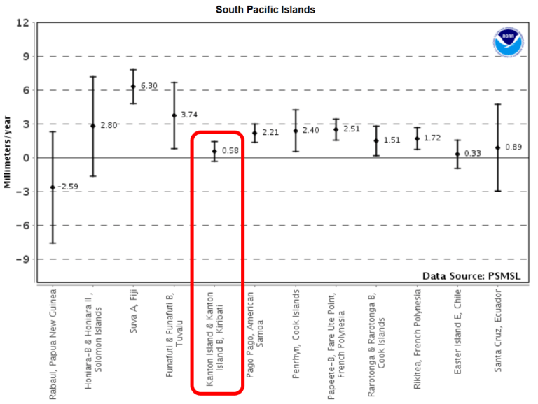
Zum Ende kommen dann noch andere Bilder.
Zufällig (und unkommentiert) im Hintergrund ein Bild, wie überflutungssicher die Häuser früher gebaut wurden, als es angeblich nie hohe Überschwemmungen gab.
Ursprüngliche, überflutungsgeschützte Bauweise.
Screenshot aus dem Video

↑ Das Europäische Parlament: Durch Folgen des Klimawandels Vertriebenen soll ein spezieller, internationaler Schutzstatus gewährt werden
-
EIKE Europäisches Institut für Klima und Energie
Helmut Kuntz
2017-06-09 de Das Europäische Parlament: Durch Folgen des Klimawandels Vertriebenen soll ein spezieller, internationaler Schutzstatus gewährt werden
↑ Crashinformation zu den "untergehenden" Pazifikinseln
-
EIKE Europäisches Institut für Klima und Energie
Helmut Kuntz
2017-06-06 de Crashinformation zu den "untergehenden" Pazifikinseln,
Teil 1: Pegelinformationen
-
EIKE Europäisches Institut für Klima und Energie
Helmut Kuntz
2017-06-08 de Crashinformation zu den "untergehenden" Pazifikinseln,
Teil 2: Zusatzinformationen
↑ Fake-News: Diesmal die Tagesschau am 18.5.2017, Totope - ein Dorf versinkt
-
EIKE Europäisches Institut für Klima und Energie
Prof. Dr. Horst-Joachim Lüdecke und Klaus-Eckart Puls
2017-06-03 de Fake-News: Diesmal die Tagesschau am 18.5.2017, Totope - ein Dorf versinktDie Fernsehjournalistin Sabine Bohland vom ARD Studio in Nairobi läutet die Alarmglocken:
"Der menschgemachte Klimawandel lässt das Meer ansteigen, ganze Küsten Afrikas saufen ab".
Ist es tatsächlich so schlimm?
Glücklicherweise nicht, denn es handelt sich um einen lupenreinen Fake. Schauen wir uns hierzu die Realität näher an!
Das Thema Meeresspiegelanstieg ist komplex und bedarf einiger Grundinformationen.
Ohne diese kann nur sachlicher Unsinn wie in der hier kritisierten Tagesschau-Sendung herauskommen.
Für diese Grundinformation möge sich der Leser bitte zuerst unser Informations-Video anschauen.
Das Video basiert auf der wissenschaftlichen Fachliteratur.
Wir empfehlen, es vollständig anzusehen.
Wer es eilig hat, kann natürlich gleich zu Minute 16:33 gehen, dort beginnt das Thema Meeresspiegel.
Aber bitte zumindest erst diesen Meerespiegelabschnitt vor dem Weiterlesen ansehen!
Fachinformation über Klima und Energie
-
EIKE Europäisches Institut für Klima und Energie
Prof. Dr. Horst-Joachim Lüdecke, EIKE Pressesprecher
2017-04-25 de
Video Folge 1: Ist der Klimawandel vom Menschen verursacht?
Das Klimagespräch mit Anton und Beate
(Extremwetter, Weltklimarat IPCC, Gletscher, Meeresspiegel)
-
EIKE Europäisches Institut für Klima und Energie
Prof. Dr. Horst-Joachim Lüdecke, EIKE Pressesprecher
2017-04-25 de Eine erste komplette Fachinformation über Klima und Energie in YoutubeEinleitung
Die Bevölkerung wird über Klima, Energiewende und Kernkraft noch nicht einmal in Ansätzen korrekt informiert.
Grob falsch oder überhaupt keine Information sind in den deutschen Medien die Regel.
Aus diesem Grunde erarbeiten wir aktuell eine Reihe von insgesamt 6 Fachinformations-Videos, jedes mit einer Dauer von 15-20 Minuten.
Totope: Fakten vs. Fake
Über Totope liegen keine Messdaten von Meeresspiegelhöhen vor.
Die nächsten Stationen im so gut wie datenfreien Afrika sind zum Glück relativ nahe.
Es sind Takoradi, etwa 300 km in nördlicher Richtung von Totope entfernt und Dakar etwa 2200 km Luftlinie weit weg.
Beide Stationen liegen wie Totope an der afrikanischen Atlantik-Küste.
Wir gehen daher von sehr ähnlichen Meereshöhenveränderungen wie bei Totope aus.
Bei Takoradi erkennen wir
Von 1930 bis 1972 (42 Jahre) einen Anstieg von etwa 220 mm, macht etwa 5 mm / Jahr ansteigenden Spiegel.
Von 1972 bis 1985 (13 Jahre) ein Abfallen von etwa 500 mm, macht etwa 38 mm / Jahr sinkenden Spiegel
Von 1985 bis heute (32 Jahre) einen Anstieg von etwa 500 mm, macht etwa 16 mm / Jahr ansteigenden Spiegel
Takoradi
Mit dem Auge geschätzt hat sich der Meeresspiegel von Takoradi in den vergangenen 90 Jahren grob um 200 mm erhöht.
Das sind etwa 0,5 mm im Jahr,
Dakar
Bei Dakar erkennen wir dagegen - so gut wie nichts!
Abgesehen von starken Monatsfluktuationen ist weder Anstieg noch Absinken des Meeresspieges über 25 Jahre erkennbar.
Ein "Klimawandel" ist in den Messwerten von Takoradi oder Dakar jedenfalls nicht zu sehen.
Mit dem Verlauf von "globalen" Lufttemperaturen oder gar des atmosphärischen CO2 in dem Zeitraum ab etwa 1930 haben demnach die Meeresspiegelveränderungen von Totope nichts zu tun.
Die "Tagesschau-Überschwemmungs-Katastrophe" ist ein Fake, in den Mesungen ist sie nicht zu finden.
-
↑ Der Meerespegel steigt drei Mal so stark an - ohne dass sich an dessen Verlauf etwas verändert hat
-
EIKE Europäisches Institut fü Klima und Energie
Helmut Kuntz
2017-06-01 de Der Meerespegel steigt drei Mal so stark an - ohne dass sich an dessen Verlauf etwas verändert hat
↑
Robuste natürliche Variabilität der Meeresspiegelanstiegsrate
bestätigt: Keine Korrelation mit
CO2-Antrieb
en
Robust Natural Variability Affirmed In Global Sea Level Rise Rates -
No Correlation With CO2 Forcing
-
EIKE Europäisches Institut für Klima und Energie
Kenneth Richard / Chris Frey
2017-06-01 de Robuste natürliche Variabilität der Meeresspiegelanstiegsrate bestätigt: Keine Korrelation mit CO2-AntriebBeweise durch Tidenmessungen: Meeresspiegel ist VOR 1950 stärker gestiegen als danach.
Während der letzten Jahre wurde immer offensichtlicher, dass Tidenmessungen des Meeresspiegelanstiegs oftmals nicht konform gehen mit Erwartungen der Klimamodelle.
Die Modelle basieren auf der Hypothese, dass anthropogene CO2-Emissionen, welche seit etwa 1950 explosionsartig zugenommen haben.
Allerdings haben Messungen der Meeresspiegel-Trends nicht mit diesem Narrativ kooperiert.
Tidenmessungen zeigen, dass es insgesamt eine substantielle Reduktion der Rate des Meeresspiegelanstiegs gegeben hat anstatt der erwarteten Beschleunigung.
Es stellte sich heraus, die Rate der Änderung [Anstieg] des Meeresspiegels
während der ersten Hälfte des vorigen Jahrhunderts mit 2,03 ± 0,35 mm pro Jahr von 1904 bis 1953 deutlich höher lag
im Vergleich mit der zweiten Hälfte des Jahrhunderts mit 1,45 ± 0,34 mm pro Jahr von 1954 bis 2003.
Eine kleine Stichprobe regionaler Ergebnisse von Tidenmessungen (Südwestpazifik, Japan) bestätigen die Verlangsamung des Anstiegs seit Mitte des 20. Jahrhunderts.
Damit bestätigen sie, dass die höchsten Raten des Anstiegs aufgetreten waren,
bevor menschliche CO2-Emissionen stark zu steigen begannen.Zwischen den Jahren 1900 und 1950 stieg der Meeresspiegel mit einer mittleren Rate von 4,2 ± 0,1 mm pro Jahr.
Während der zweiten Hälfte des 20. Jahrhunderts betrug die rekonstruierte relative Rate des Anstiegs 0,7 ± 0,6 mm pro Jahr.
Unsere Studie ist konsistent mit einer ähnlichen Situation der relativen Änderung des Meeresspiegels, welche für das südliche Neuseeland rekonstruiert worden war.
Die Variabilität des Meeresspiegels um Japan von 1906 bis 2010 wurde untersucht mittels eines regionalen Ozean-Modells zusammen mit gemessenen Daten und den historischen Simulationen der CMIP5-Modelle.
Das regionale Modell reproduziert die beobachtete Variabilität des Meeresspiegels von Jahrzehnt zu Jahrzehnt,
z. B. den hohen Meeresspiegel um das Jahr 1950,
einen niedrigeren Meeresspiegel während der siebziger Jahre
sowie einen Anstieg des Meeresspiegels während der letzten drei Jahrzehnte entlang der japanischen Küste. ...
Dass der wind-induzierte Anstieg entlang der japanischen Küste um 1950 genauso hoch war wie der jüngste Anstieg, unterstreicht die Bedeutung der natürlichen Variabilität bzgl. des Verständnisses regionaler Änderungen des Meeresspiegels im Zeitmaßstab von Jahrzehnten.
Die nominale Bestimmung des absoluten globalen Meeresspiegels mittels altimeter-basierter Satellitenbeobachtungen ist tatsächlich eher eine berechnetes Ergebnis als eine direkte Messung.
Man erhält es durch Korrektur des Rohsignals der Satelliten-Altimeter-Messungen mittels Algorithmen, welche viele Gemeinsamkeiten mit Klimamodellen aufweisen.
Unabhängig von irgendwelchen Problemen bei der Modellierung haben Carter et al. 2014 darauf hingewiesen, dass Schätzungen der Änderungen des Meeresspiegels mittels von Satelliten ermittelter Daten problematisch bleiben wegen der vielen Unsicherheiten bei der Datengewinnung und -verarbeitung.
Im besonderen besteht eine Inkonsistenz zwischen den von verschiedenen Forschungsgruppen abgeleiteten Daten, wobei alle Ergebnisse abhängig sind von der Genauigkeit komplexer Adjustierungen, wobei Einigen eine unabhängige Verifikation fehlt, sowie von dem ernsten Problem, dass das erwünschte Signal im Rauschen der verwendeten Daten untergehen könnte.
Viele Korrekturen an allen Satelliten-Altimeter-Messungen des Meeresspiegels seit 2003 hatten den Effekt, eine Meeresspiegel-Aufzeichnung zu verändern, die entweder gar keinen oder nur einen geringen Trend zeigte im Gegensatz zu Verfahren, die hohe Anstiegsraten projizierten.
Permanent Service for Mean Sea Level (PSMSL)
Eine Aktualisierung der jüngsten PSMSL-Tabelle der säkularen Trends des relativen Meeresspiegels vom 14. Februar 2014 (www.psmsl.org)
vergleicht die relativen Anstiegsraten, berechnet aus 2133 Tidenmessungen
verschiedener zeitlicher Länge (Maximum 183 Jahre, Minimum 21 Jahre) mit den jüngeren, kürzesten Ablesungen, zumeist in Gebieten mit Absinken [der Landmasse] und einer sehr uneinheitlichen geographischen Abdeckung.
Die mittlere Rate des Anstiegs aus den 2133 Tidenmesspunkten beträgt 1,04 ± 0,45 mm pro Jahr.
-
NoTricksZone (Pierre L. Gosselin)
Kenneth Richard
2017-04-25 en Robust Natural Variability Affirmed In Global Sea Level Rise Rates - No Correlation With CO2 Forcing
↑ Vorindustrieller Effekt: Meeresspiegelanstieg in New Jersey begann sich bereits vor 600 Jahren zu beschleunigen
-
Die kalte Sonne (Fritz Vahrenholt & Sebastian Lüning)
2017-05-16 de Vorindustrieller Effekt: Meeresspiegelanstieg in New Jersey begann sich bereits vor 600 Jahren zu beschleunigen
↑ Recent Sea-Level Change at Major Cities
-
Watts Up With That? (Antony Watts)
Rich Taylor
2017-03-29en Recent Sea-Level Change at Major Cities
⇧ 2016
↑
Tidenmessstationen zeigen einen nur um 1,48 mm steigenden
Meeresspiegel pro Jahr
weniger als die Hälfte der von Satelliten gemessenen Werte
en
Tide Gauges Show Sea Level Rising Only 1.48 mm Per Year
Less Than Half The Satellite-Claimed Rate!
-
EIKE Europäisches Institut für Klima und Energie
Pierre L. Gosselin
2016-04-16 de Falsche Satelliten-Altimetrie? 225 Tidenmessstationen zeigen einen nur um 1,48 mm steigenden Meeresspiegel pro Jahr ... weniger als die Hälfte der von Satelliten gemessenen Werte
-
NoTricksZone (Pierre L. Gosselin)
2016-04-11 en Broken Altimetry? 225 Tide Gauges Show Sea Level Rising Only 1.48 mm Per Year ... Less Than Half The Satellite-Claimed Rate!
-
SeaLevel.info
en Home
⇧ 2015
↑ Antarktische Eiskappe wächst derzeit und bremst globalen Meeresspiegelanstieg
-
Die kalte Sonne (Fritz Vahrenholt & Sebastian Lüning)
2015-12-31 de NASA-Studie mit überraschendem Befund: Antarktische Eiskappe wächst derzeit und bremst globalen Meeresspiegelanstieg
↑ WWF-Studie: Wattenmeer wächst mit dem Meeresspiegel in die Höhe
-
Die kalte Sonne (Fritz Vahrenholt & Sebastian Lüning)
2015-12-26 de WWF-Studie: Wattenmeer wächst mit dem Meeresspiegel in die Höhe
↑ Versickernde Sintflut
-
EIKE Europäisches Institut für Klima und Energie
2015-12-25 de Versickernde SintflutDer Meeresspiegel steigt
Ja, es stimmt, der Meeresspiegel steigt.
Vor 15000 Jahren
Aber, er tut dies nachgewiesenermaßen seit 15000 Jahren.
Damals lag der Meeresspiegel um 140 Meter tiefer als heute.
Gegen Ende der letzten Eiszeit
Er stieg an, als gegen Ende der letzten Eiszeit die Inlandsgletschermassen abschmolzen.
Diese Entwicklung ist noch immer nicht zum Stillstand gekommen.
Sie setzt sich fort, wenn auch mittlerweile stark abgebremst.
Von 1600 - also bereits in vorindustrieller Zeit - bis heute ist die Nordsee um 135 Zentimeter gestiegen.
Das sind etwa 34 Zentimeter pro Jahrhundert.
Von 1900 bis 2000
Von 1900 bis 2000 stieg der Pegel in Cuhaven nur um 25 Zentimeter, also eher im unteren Randbereich der 100-Jahres-Schwankungen.
"Der Anstieg des Meeresspiegels erfolgte in den letzten 400 Jahren noch nie so langsam wie im 20. Jahrhundert", stellt der Physiker und Meteorologe Klaus-Eckart Puls, ehemals Leiter der Wetterämter in Essen und Leipzig, in einem Aufsatz fest.
Der Niedersächsische Landesbetrieb für Wasserwirtschaft, Küsten- und Naturschutz (NLWKN) hat aus der Beobachtung des Pegels in Norderney ebenfalls seine Schlüsse gezogen und konstatiert:
"Ein beschleunigter Anstieg des Meeresspiegels kann nicht nachgewiesen werden."
Verblüffende Höhenunterschiede.
Das kann anderswo allerdings tatsächlich anders aussehen. 71 Prozent der Erde sind von Wasser bedeckt.
Wer dessen Oberfläche genauer betrachtet, erlebt Überraschungen.
So hat der Meeresspiegel keineswegs überall die gleiche Höhe.
Ursache ist unter anderem die ungleichmäßige Verteilung dichter Gesteine im Erdinneren.
Dadurch wird das Wasser unterschiedlich stark angezogen.
Die Folge sind verblüffende Höhenunterschiede.
Sie betragen zum Beispiel zwischen dem Südatlantik und dem Indischen Ozean 200 Meter.
Bangladesch gewinnt Land
Der Hamburger Professor für Küsteningenieurswesen Winfried Siefert stellte schon vor einigen Jahren fest:
Tatsächlich verliert Bangladesch kein Land an die Fluten, sondern gewinnt welches.
Das stellte das Institut für Umwelt und Geographie mit Sitz in der Hauptstadt Dhaka fest.
Es wertete die Satellitendaten mehrerer Jahrzehnte aus.
Das Ergebnis: Bangladeschs Landmasse nimmt jährlich um 20 Quadratkilometer zu.
Seit 1973 summierte sich der Landgewinn auf rund 1000 Quadratkilometer.
Ursache sind unter anderem die großen Mengen Schwebstoffe, die von den Strömen Brahmaputra und Ganges in die Flussmündungen getragen werden.
Dort lagern sie sich dann ab.
Ebenfalls wachsender Landbesitz südlicher Inselstaaten
Ebenfalls über wachsenden Landbesitz können sich die Bewohner vieler südlicher Inselstaaten freuen, klammheimlich am besten, denn wie so viele Staaten fordern sie von den Industrienationen eine Menge Geld, um sich gegen den drohenden Klimawandelzu wappnen.
Da kommt es gar nicht gut, wenn Wissenschaftler feststellen, dass beispielsweise einige der Fidschi-Inseln in den letzten Jahren um bis zu 30 Prozent gewachsen sind.
Hier sind keine Schwebstoffe, sondern Korallen für den Landgewinn verantwortlich.
Die koloniebildenden, kalkablagernden Nesseltiere scheren sich keinen Deut um angeblich steigende Meeresstände.
Für sie zählt einzig die Realität knapp unter dem Meeresspiegel.
↑ en Hiding The Sea Level Decline
-
Real Science
2015-10-31 en Hiding The Sea Level Decline At The University Of Colorado
↑ en Florida Sea Level Rise Rates Are Half What They Used To Be
-
Real Science (Steven Goddard)
2015-09-30 en Florida Sea Level Rise Rates Are Half What They Used To Be
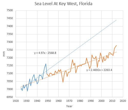
↑ Meeresspiegelforschung aktuell: Neue Studien aus Europa
-
Die kalte Sonne (Fritz Vahrenholt & Sebastian Lüning)
2015-07-18 de Meeresspiegelforschung aktuell: Neue Studien aus Europa
↑ Lange bevor der Mensch die Atmosphäre veränderte: Meeresspiegel stieg in den letzten 2000 Jahren zeitweise so schnell wie heute
-
Die kalte Sonne (Fritz Vahrenholt & Sebastian Lüning)
2015-07-15 de Lange bevor der Mensch die Atmosphäre veränderte: Meeresspiegel stieg in den letzten 2000 Jahren zeitweise so schnell wie heute
↑ Was Klimamodelle bislang unberücksichtigt ließen: Bis zu einem Viertel des Meeresspiegelanstiegs geht auf Änderungen im Salzgehalt der Ozeane zurück
-
Die kalte Sonne (Fritz Vahrenholt & Sebastian Lüning)
2015-07-14 de Was Klimamodelle bislang unberücksichtigt ließen: Bis zu einem Viertel des Meeresspiegelanstiegs geht auf Änderungen im Salzgehalt der Ozeane zurück
↑ Meeresspiegelanstieg bleibt hinter den Erwartungen zurück: Jetzt kann nur noch eine "Datenmassage" helfen
-
Die kalte Sonne (Fritz Vahrenholt & Sebastian Lüning)
2015-07-13 de Meeresspiegelanstieg bleibt hinter den Erwartungen zurück: Jetzt kann nur noch eine "Datenmassage" helfenDer Meeresspiegel steigt, das ist eine Tatsache.
Eine große Überraschung ist dies jedoch nicht, denn der Meeresspiegel steigt nämlich schon seit 15.000 Jahren, seit Ende der letzten Eiszeit.
Nun ist dieser Anstieg nicht gleichmäßig über die Zeit verteilt.
In warmen Zeiten wie heute oder während der Mittelalterlichen Wärmeperiode steigt der Meeresspiegel schneller, in kalten Zeiten wie der Kleinen Eiszeit verlangsamt sich der Anstieg.
In den letzten 23 Jahren, seit Beginn der Satellitenmessungen, stieg der Meeresspiegel mit gut 3 mm pro Jahr an.
Eine Beschleunigung ist beim besten Willen nicht zu erkennen.
Während die Meeresspiegelwerte im 20. Jahrhundert zum allergrößten Teil von Küstenpegeln stammen, werden für die letzten zwei Jahrzehnte Satellitenmessungen verwendet.
Diese sind jedoch nicht direkt vergleichbar, denn die Satellitenwerte fallen deutlich höher aus, als die noch immer weiter gemessenen Küstenpegelpegel.
Es wird vermutet, dass der Korrekturfaktor bei den Satellitenmessungen zu hoch angesetzt ist (siehe auch Beitrag von Klaus-Eckart Puls auf EIKE).
Um ganz auf Nummer sicher zu gehen, haben die Autoren und Carling Hay und Eric Morrow zu allem Überfluss auch noch die historischen Messwerte des 20. Jahrhunderts künstlich nach unten gedrückt. Eine hochfragwürdige nachträgliche Datenmassage.
↑ Neue Meeres-Spiegel-Studie zeigt: Satelliten-Daten überhöht !
-
EIKE Europäisches Institut für Klima und Energie
Klaus-Eckart Puls
2015-04-13 de Neue Meeres-Spiegel-Studie zeigt: Satelliten-Daten überhöht !
⇧ 2014
↑ Säkularer und Aktueller Meeres-Anstieg: Pegel (1.6 mm/Jahr) oder SAT-Altimeter (3.2 mm/Jahr) - WAS ist richtig ?
-
EIKE Europäisches Institut für Klima und Energie
2014-07-08 de Säkularer und Aktueller Meeres-Anstieg: Pegel (1.6 mm/Jahr) oder SAT-Altimeter (3.2 mm/Jahr) - WAS ist richtig ?Zahlreiche Auswertungen von Küsten-Pegel-Messungen über 200 Jahre sowie neuerdings von Schwere-Messungen der GRACE-Satelliten ergeben immer wieder einen Meeres-Anstieg von etwa 1,6 mm/yr.
Dagegen stehen die seit 1992 publizierten Altimeter-Messungen mit den Satelliten-Systemen TOPEX/POSEIDON/JASON mit doppelt so hohen Werten von 3,2 mm/yr.
Die erhebliche Diskrepanz ist bis heute ungeklärt.
Dabei stimmen jedoch immerhin die Trends überein:
Der Meeres-Anstieg verläuft seit wenigstens 100 Jahren linear, es gibt keine Beschleunigung des Anstieges.Ein Signal durch anthropogenes CO2 (AGW) ist nirgends erkennbar.
Das alles steht in krassem Widerspruch zu den Verlautbarungen und insbesondere zu den alarmistischen Prognosen des Klimarates IPCC und einiger Klima-Institute.
↑ Kehrtwende in der Staatskommunikation auf den Malediven: Präsident der Inselgruppe versichert, dass die Malediven nicht untergehen werden
-
Die kalte Sonne (Fritz Vahrenholt & Sebastian Lüning)
2014-01-20 de Kehrtwende in der Staatskommunikation auf den Malediven: Präsident der Inselgruppe versichert, dass die Malediven nicht untergehen werden
↑ Ozeanzyklen spielen auch im Atlantik und Mittelmeer eine wichtige Rolle für die Meeresspiegelentwicklung: Wer die Zyklen nicht berücksichtigt oder mit zu kurzen Datensätzen operiert, argumentiert unseriös
-
Die kalte Sonne (Fritz Vahrenholt & Sebastian Lüning)
2014-01-19 de Ozeanzyklen spielen auch im Atlantik und Mittelmeer eine wichtige Rolle für die Meeresspiegelentwicklung: Wer die Zyklen nicht berücksichtigt oder mit zu kurzen Datensätzen operiert, argumentiert unseriös
↑ Neue Studie der Universität Siegen: Meeresspiegel in der Nordsee steigt seit 100 Jahren mit konstanter Geschwindigkeit - keine Beschleunigung
-
Die kalte Sonne (Fritz Vahrenholt & Sebastian Lüning)
2014-01-15 de Neue Studie der Universität Siegen: Meeresspiegel in der Nordsee steigt seit 100 Jahren mit konstanter Geschwindigkeit - keine Beschleunigung
⇧ 2013
↑ Wo bleibt der Meeres-Anstieg ? Verlangsamung statt Beschleunigung !
-
EIKE Europäisches Institut für Klima und Energie
2013-12-11 de Wo bleibt der Meeres-Anstieg ? Verlangsamung statt Beschleunigung !
↑ Hebrew University of Jerusalem: Globaler Meeresspiegelanstieg beträgt laut Pegelmessungen lediglich 1 Millimeter pro Jahr
-
Die kalte Sonne (Fritz Vahrenholt & Sebastian Lüning)
2013-10-23 de Hebrew University of Jerusalem: Globaler Meeresspiegelanstieg beträgt laut Pegelmessungen lediglich 1 Millimeter pro Jahr
↑ en New paper finds sea levels rising at less than 4 inches per century, with no acceleration
-
THE HOCKEY SCHTICK
2013-09-21 en New paper finds sea levels rising at less than 4 inches per century, with no acceleration
↑ Neue GRACE-Satellitenstudie: Schmelz- und Grundwasserzufluss ließ Meeresspiegel in den letzten 10 Jahren lediglich um 1,1 mm pro Jahr ansteigen
-
Die kalte Sonne (Fritz Vahrenholt & Sebastian Lüning)
2013-09-14 de Neue GRACE-Satellitenstudie: Schmelz- und Grundwasserzufluss ließ Meeresspiegel in den letzten 10 Jahren lediglich um 1,1 mm pro Jahr ansteigen
↑ Sylter Erlebniszentrum Naturgewalten geht mit unseriösen Meeresspiegel-Szenarien auf Besucherfang
-
Die kalte Sonne (Fritz Vahrenholt & Sebastian Lüning)
2013-08-14 de Sylter Erlebniszentrum Naturgewalten geht mit unseriösen Meeresspiegel-Szenarien auf Besucherfang
↑ Gletschersterben in Grönland überschätzt: Meeresspiegel steigt wohl doch langsamer als befürchtet
-
Die kalte Sonne (Fritz Vahrenholt & Sebastian Lüning)
2013-05-10 de Gletschersterben in Grönland überschätzt: Meeresspiegel steigt wohl doch langsamer als befürchtet
↑ Meeresspiegel in der Adria stagnierte während Kältephasen und beschleunigte sich während Wärmephasen
-
Die kalte Sonne (Fritz Vahrenholt & Sebastian Lüning)
2013-02-26 de Meeresspiegel in der Adria stagnierte während Kältephasen und beschleunigte sich während Wärmephasen
↑ Von 2011 bis Mitte 2012 fiel der Meeresspiegel um 5 mm: Wechsel von El Nino auf La Nina füllte Seen und Grundwasservorräte auf
-
Die kalte Sonne (Fritz Vahrenholt & Sebastian Lüning)
2013-01-15 de Von 2011 bis Mitte 2012 fiel der Meeresspiegel um 5 mm: Wechsel von El Nino auf La Nina füllte Seen und Grundwasservorräte aufQuelle / Source:
2012-10-04 en The 2011 La Niña: So strong, the oceans fell
↑
Ozeanbojen und Schwerefeldmessungen belegen:
Meeresspiegel steigt nur halb so schnell wie vom IPCC
prognostiziert
-
Die kalte Sonne (Fritz Vahrenholt & Sebastian Lüning)
2013-01-13 de Ozeanbojen und Schwerefeldmessungen belegen:
Meeresspiegel steigt nur halb so schnell wie vom IPCC prognostiziertDie US-amerikanische National Oceanic and Atmospheric Administration (NOAA) hat vor kurzem mithilfe der zuletzt genannten Argo / GRACE-Methode die globale Meeresspiegelentwicklung für die letzten sieben Jahre, also von 2005-2012 bestimmt.
Laut der Untersuchung ist der Meeresspiegel in dieser Zeit um lediglich 1,1 - 1,3 mm pro Jahr angestiegen.
Dies ist weniger als die Hälfte der vom IPCC angenommenen Anstiegsrate von 3,1 mm/Jahr.
Auszüge aus der neuen NOAA-Studie sind in einem Artikel auf The Hockey Schtick zitiert.
↑ Meeresspiegelanstieg: Grönland-Eis schmilzt langsamer als erwartet
-
Spiegel Online
2013-05-09 de Meeresspiegelanstieg: Grönland-Eis schmilzt langsamer als erwartetDie Schmelze in Grönland entscheidet wesentlich darüber, wie schnell der Meeresspiegel steigt.
Nun zeigt die Forschung an fünf Gletschern des Landes:
Die nordische Eiskappe wird wohl gemächlicher tauen als angenommen.
Auf ganz Grönland übertragen rechnen sie mit einem Anstieg bis zum Jahr 2100 um höchstens 18 Zentimeter.
Die neuen Schätzungen liegen im Rahmen der Prognose des Uno-Klimarats IPCC.
Manche Studien hatten die Befürchtung genährt, der IPCC könnte die Schmelze in Grönland unterschätzen.
⇧ 2012
↑
NOAA 2012 report finds:
Sea levels rising at less than half the rate
claimed by the IPCC
-
THE HOCKEY SCHTICK
2012-12-11 en NOAA 2012 report finds:
Sea levels rising at less than half the rate claimed by the IPCCAccording to the latest NOAA sea level budget, global sea levels rose
at only 1.1 - 1.3 mm/year from 2005-2012,
which is less than half of the rate claimed by the IPCC [3.1 mm/yr]
and is equivalent to less than 5 inches per century.
Contrary to alarmist claims, sea level rise decelerated over the 20th century, has also decelerated since 2005, and there is no evidence of any human influence on sea levels.
↑ Fallstudien aus aller Welt belegen: Keine Beschleunigung des Meeresspiegelanstiegs während der letzten 30 Jahre
-
Die kalte Sonne (Fritz Vahrenholt & Sebastian Lüning)
2012-07-11 de Fallstudien aus aller Welt belegen: Keine Beschleunigung des Meeresspiegelanstiegs während der letzten 30 Jahre
↑ Fallstudien aus aller Welt belegen: Beschleunigte Meeresspiegelanstiege gehören schleunigst in die Mottenkiste
-
Die kalte Sonne (Fritz Vahrenholt & Sebastian Lüning)
2012-07-08 de Beschleunigte Meeresspiegelanstiege gehören schleunigst in die Mottenkiste
↑ Fallstudien aus aller Welt belegen: Überraschung: Meeresspiegelanstieg hat sich in den letzten Jahren verlangsamt
-
Die kalte Sonne (Fritz Vahrenholt & Sebastian Lüning)
2012-10-18 de Überraschung: Meeresspiegelanstieg hat sich in den letzten Jahren verlangsamt
↑ Globaler Meeres-Spiegel : Der Anstieg schwächt sich weiter ab!
-
EIKE Europäisches Institut für Klima und Energie
2012-10-07 de Globaler Meeres-Spiegel : Der Anstieg schwächt sich weiter ab!Seit ca. 150 Jahren gibt es an den Meeres-Küsten zahlreiche Pegelmessungen, seit 1992 Messungen von Satelliten mit Kurzwellenradar-Systemen.
Alle zeigen den gleichen Trend, nämlich:
Eine Abschwächung des Millennium-Anstieges.
Das Parade-Pferd der Warmisten und Alarmisten lahmt !
↑ Nachträgliche Korrekturen der Satelliten-Meeresspiegeldaten: Was nicht passt wird passend gemacht?
-
Die kalte Sonne (Fritz Vahrenholt & Sebastian Lüning)
2012-07-14 de Nachträgliche Korrekturen der Satelliten-Meeresspiegeldaten: Was nicht passt wird passend gemacht?
↑ Meeresspiegelanstieg hat sich in den letzten 7 Jahren verlangsamt
-
Die kalte Sonne (Fritz Vahrenholt & Sebastian Lüning)
2012-07-07 de Meeresspiegelanstieg hat sich in den letzten 7 Jahren verlangsamt
↑ Bangladesch und die Pazifikinseln wachsen trotz steigendem Meeresspiegel: Klimamodellierer benötigen dringend Nachhilfe in Geologie
↑ No Sea Level Rise Acceleration - Study Shows "Similar Rates Could Also Be Identified Earlier In The Record"
-
NoTricksZone
2012-04-11 de No Sea Level Rise Acceleration - Study Shows "Similar Rates Could Also Be Identified Earlier In The Record"
⇧ 2011
↑
Modellberechnungen und Manipulationen statt Meßdaten -
Wie die Verlangsamung des Meeresspiegelanstiegs geleugnet wird
en More hiding the decline
-
Klimaskeptiker Info (Andreas Kreuzmann)
2011-08-12 de Modellberechnungen und Manipulationen statt Meßdaten - Wie die Verlangsamung des Meeresspiegelanstiegs geleugnet wirdSeit etwa 5 Jahren hat sich der Anstieg des Meeressppiegels, wie er von der Universität von Colorado in Boulder errechnet wird, verlangsamt.
Diese Tatsache paßt natürlich überhaupt nicht ins alarmistische Weltbild, in dem die vermeintlich durch CO2 ausgelöste globale Erwärmung zu einer Beschleunigung des Meeresspiegelansteigs führen müßte.
Was passiert nun mit Daten, die nicht zum gewünschten Ergebnis passen?
Sie müssen "angepaßt" werden.
-
EcoTretas
2011-07-19 en More hiding the declineDespite the fact that sea level has been going down for the last year, they are saying that sea level rise rate is going up!
-
en
Since August 1992 the satellite altimeters have been measuring sea level on a global basis with unprecedented accuracy.
Universtiy of Colorado at Boulder en Sea level change
- ICECAP en James Hansen: Abusing the Public Trust
- Climat Sceqtique fr Les leçons de Carl Wunsch: Hausse du niveau des mers
- iceagenow.com en Falling sea levels
de Aus der Panik-Küche en From the panic laboratory fr De la marmite des alarmistes
-
YouTube Video en
The Past Half-Century of Sea Level Rise
In his testimony before the U.S. House of Representatives Select Committee on Energy Independence and Global Warming, NASAs James Hansen stated there is increasing realization that sea level rise this century may be measured in meters if we follow business-as-usual fossil fuel emissions.
Agreeing with Hansen, many people have been quick to jump on the CO2-induced global warming/rising sea level bandwagon.
But how close to reality are the projections of a future sea level rise that is measured in meters?
↑
MeeresspiegelGate
en Sea Level Gate
|
Nils-Axel Mörner *1938 †2020-10-16 |
Dr., Head of the Paleogeophysics and Geodynamics department at
Stockholm University in Sweden. 2000-2007 Hauptberichterstatter beim IPCC für den Meeresspiegel-Anstieg. ▶Nils-Axel Mörner: Who is who (Skeptiker) ▶Nils-Axel Mörner: Who is who (Skeptische Wissenschaftler des IPCC) ▶Nils-Axel Mörner: Video (Präsentationen) ▶Ausschluss und Maulkorb für Kritiker (Nils-Axel Mörner und das IPCC) |
⇧ 2010
↑
Was ist dran am globalen Anstieg des Meeresspiegels?
en
Sea Level Rises... What Sea Level Rises?
|
|
|
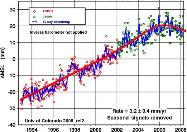
-
EIKE Europäisches Institut für Klima und Energie
2010-02-08 de Was ist dran am globalen Anstieg des Meeresspiegels?Das IPCC - häufig hochtrabend "Weltklimarat" genannt - scheut sich nicht auch noch die krudesten Zeitungsenten, sofern sie von Umweltgruppen wie dem WWF kommen und ins Panikkonzert passen, als "wissenschaftlichen" Beleg für seine Phantasien zu bezeichnen.
So wieder geschehen mit der Tartarenmeldung über die Niederlande im IPCC-Bericht 2007.
Dort steht: "Die Niederlande sind das Beispiel dafür, dass das Land sowohl von der Steigung des Meeresspiegels als auch durch Überschwemmungen der Flüsse gefährdet ist, denn 55 Prozent des Landes liegen unter dem Meeresspiegel."
Wie so häufig beim IPCC stimmt auch das nicht, denn nur 26 Prozent der Fläche der Niederlande, (die 41 525 Quadratkilometer beträgt), liegen unter dem Meeresspiegel.
Und bedroht sieht sich dort niemand. Selbst die niederländische Umweltministerin Jaqueline Kramer glaubt diesen Humbug nicht und fordert eine Untersuchung.
Man fragt sich allerdings wofür?
Was es wirklich mit dem Meeresspiegel auf sich hat, erklärt uns einer der weltweit besten Meeresspiegel Experten N.A. Mörner im Glashouse Interview.
-
EIKE Europäisches Institut für Klima und Energie
2010-06-07 de Anstieg des Meeresspiegels - welcher Anstieg?Eine der vielen Präsentationen auf der 4. Internationalen Klimakonferenz des Heartland Instituts (Heartland Institute's fourth International Conference on Climate Change) stammte vom Meeresspiegelexperten Nils Axel Mörner, dem inzwischen emeritierten Leiter des Fachbereichs Paläogeophysik und Geodynamik an der Universität von Stockholm.
Sein Vortrag konzentrierte sich auf den vermuteten Anstieg des Meeresspiegels und den Unterschied zwischen dem tatsächlichen Anstieg und dem vom IPCC stammenden diesbezüglichen Modellergebnissen.
Von den Alarmisten wurden Mörners Arbeiten immer wieder in Zweifel gezogen, z.T. versucht lächerlich zu machen.
Die jüngsten Medien-Berichte zur Ausweitung der Fläche von Bangladesh und des Anstiiegs der Südseeinseln von Tuvalu und den Malediven (s.u) geben ihm jedoch mal wieder eindrucksvoll Recht.
-
Welt Online/Michael Miersch
2010-06-05 de Die Drohkulisse der Untergangspropheten ist wegAngeblich versinkende Südseeinseln sind ein starkes Kapitel in der großen Erzählung von einer herannahenden Klimakatastrophe.
Wie schwindende Eisbären und die schmelzende Gletscher weckt die Botschaft von den untergehenden Tropenparadiesen heftigere Gefühle als dürre Temperaturkurven.
Dass die Bestände der Eisbären sich erfreulich vermehren, haben Zoologen schon vor Jahren dokumentiert (obwohl Al Gore und seine Freunde weiterhin das Gegenteil behaupten).
Dass die Gletscher im Himalaja längst nicht so schnell schmelzen wie der Weltklimarat behauptet, bewiesen indische Wissenschaftler vergangenen Herbst.
Und jetzt versinkt auch noch das Insel-Szenario.
Forscher von den Fidschi-Inseln und aus Neuseeland veröffentlichten diese Woche einen Vergleich historischer und aktueller Luftaufnahmen von 27 Pazifik-Inseln.
Ergebnis: 23 davon sind seit den 50er-Jaren gleich groß geblieben oder gewachsen.
Sogar der Inselstaat Tuvalu, der immer wieder als dem Untergang geweiht dargestellt worden war, besitzt heute mehr Landfläche als damals.
Sieben seiner neun Atolle wurden größer.
Ähnlich gut sieht es für Malediven im indischen Ozean aus, deren Ministerpräsident vor dem Kopenhagener Klimagipfel medienwirksam unter Wasser posiert hatte.
Und auch die Küstenlinie von Bangladesch weitet sich aus, statt zu schrumpfen.
-
Spiegel Online
2010-06-03 de Überraschendes Forschungsergebnis: Pazifikinseln werden trotz Meeresspiegel-Anstieg größer
2001-12-22 de Die Südsee-Ente: Wie der Pazifikstaat Tuvalu unterging - beinahe
-
DiePresse
2007-06-02 de "Tuvalu versinkt nicht, definitiv nicht"
-
The Heritage Foundation
2010-05-21 en Sea Level Rises... What Sea Level Rises?Another one of the standout presentations at the Heartland Institute's fourth International Conference on Climate Change was the one by Nils-Axel Morner, former emeritus head of the paleogeophysics and geodynamics department at Stockholm University.
His talk focused on sea level increases and the difference between observed data and the Intergovernmental Panel on Climate Change (IPCC) model's predictions.
-
Watts Up With That? (Antony Watts)
2010-06-02 en Tuvalu and many other South Pacific Islands are not sinking, claims they are due to global warming driven sea level rise are opportunistic
-
Telegraph UK
2010-03-28 en Rise of sea levels is 'the greatest lie ever told'The uncompromising verdict of Dr Mörner is that all this talk about the sea rising is nothing but a colossal scare story
-
Environment
2010-06-02 en Shape-shifting islands defy sea-level rise
⇧ 2009
↑
Meeresspiegel fällt weiter
en
Sea Level Continues Its Historic Decline
de
Envisat: Meeresspiegel fällt weiter
en
Envisat: Sea Level Continues Its Historic Decline
|
|
|

↑ en Sea Level in the Southwest Pacific is stable
Graphs of sea level for twelve locations in the southwest Pacific show stable sea level for about ten years over the region.
The data ... suggest that any rise of global sea level is negligible.
![]()
![]()
![]() The sites of sea level monitoring stations.
The sites of sea level monitoring stations.

-
The New Zealand Climate Coalition
2009-08-04 en Sea Level in the Southwest Pacific is stable
-
The South Pacific Sea Level & Climate Monitoring Project
2009-06 en
Sea Level in the Southwest Pacific is stable
-
The New Zealand Climate Coalition
2009-07-01 en Why Ice Sheets won't raise Sea Level
• Shelf ice is floating, because it is less dense than seawater.
When floating ice melts, there is no change in sea level.
This is a bit of elementary physics known as Archimedes' Principle.
• The breakup of ice shelves is normal and inevitable.
Ice caps grow by precipitation in the uplands, flow at depth, and at the ice front the ice either melts or breaks off as icebergs.
The ice never simply keeps flowing to the equator.
Icebergs are produced in both times of climate warming and times of cooling, so they tell us nothing of climate change.
• Antarctica: The Department of Atmospheric Sciences at the University of Illinois provides data on sea ice anomalies.
On 22 May 2009 global sea ice was 2.6% ABOVE the 1979-2000 average.
• Satellite data from 1982 to 2003 (published in the Journal of the Royal Society) showed that the Antarctic icesheet is growing higher from precipitation at about 5 mm/yr which would LOWER sea level.
• In Scandinavia, which is rising in response to loss of the old ice sheet the sea level is falling: Goteborg, Sweden -1.3 mm/yr; Oslo, Norway -4.53 mm/yr.
• Two favourites of sea level alarmists are Tuvalu and the Maldives.
Sea level measurements for Tuvalu (and 10 other stations) between 1992 and 2006 are available on Fig. 13 on the Australian Bureau of Meteorology website.
For about the past eight years the sea level seems to be virtually constant.
Sea level in the Maldives was studied in enormous detail by the doyen of sea level scientists, Niklas Axel-Mörner.
His team determined the sea level curve over the past 5,000 years based on evidence of morphology, stratigraphy, biology and archaeology supported by extensive C14 dating, and found that
"All over the Maldives there is evidence of a sub-recent sea level some 20 cm higher than the present one.
In the 1970s, sea level fell to its present position."
-
The South Pacific Sea Level & Climate Monitoring Project
2008-09 en
MONTHLY DATA REPORT
↑
Meeresspiegel im Jahr 2010 um 6 mm gefallen - NASA nennt den
Rückgang ein "Schlagloch auf dem Weg zu einem höheren
Meeresspiegel"
en
NASA Satellites Detect Pothole on Road to Higher Seas
de
NASA: "Schlagloch auf dem Weg zu einem höheren Meeresspiegel"
en
NASA: "Pothole on Road to Higher Seas"
|
|
|
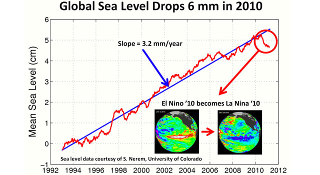
↑ Meeresspiegel steigt seit 2006 kaum oder gar nicht
-
Klimaskeptiker Info
2009-07-18 de Meeresspiegel steigt seit 2006 kaum oder gar nicht
↑ Global Sea Level Updated at UC - still flattening
-
Whats Up With That? (Antony Watts)
2009-07-18 en Global Sea Level Updated at UC - still flattening
↑ Another look at UC sea level data
-
Whats Up With That? (Antony Watts)
2009-07-18 en Another look at UC sea level data
↑ en Sea level may drop in 2010
-
Watts Up With That? (Antony Watts)
2011-01-17 en Sea level may drop in 20102006 was the first year to show a drop in the global sea level.
2010 will be the 2nd year to show a decrease in sea level.
2010 could likely show a significant drop global sea level.
By significant I mean it is possible that it will likely drop between 2-3 mm from 2009.
↑
Teil 2: Meeresspiegel in der Vergangenheit
en Sea Level History
fr L'hisoire des niveaux des mers
Topics
|
|
de
Meeresspiegel-Anstieg vor Kohlenwasserstoff-Anstieg:
en
Sea level rise before Hydrocarbon use increase:
fr
Augmentation du niveau des océans avant l'augmentation des hydrocarbures: |

![]()
![]() Meeresspiegelentwicklung an der Westküste Südafrikas
Meeresspiegelentwicklung an der Westküste Südafrikas
während der letzten 9000 Jahre (BP=years before present).
Es gilt die durchgezogene Linie (nicht die gestrichelte).

de Weltklimarat IPCC in seinem Bericht von 1990:
"Es gibt keine überzeugenden Hinweise darauf, dass sich der Meeresspiegelanstieg im 20. Jahrhundert beschleunigt hätte"
en German Review: Sea Level Rise Way Below Projections
No Hard Basis For Claims Of Accelerating Rise - IPCC 1990: "No convincing evidence that sea level rise accelerated in the 20th century"
| de Siehe auch | → Teil 1: Aktuelle Situation |
| en See also | → Part 1: Actual Situation |
| fr Voir également | → Partie 1: Situation actuelle |
de Verzeichnis en Contents fr Sommaire
- 2018
- de Im südlichen Afrika lag der Meeresspiegel vor 5000 Jahren um 3 m höher als heute
- 2016
- de Polare Eisschilde stabiler als gedacht, Meeresspiegelanstieg weniger dramatisch als befürchtet
- 2015
- de In der Antike lag Ephesos (Türkei) direkt am Meer
- 2013
- de Meeresspiegel in der Adria stagnierte während Kältephasen und beschleunigte sich während Wärmephasen
- 2009
-
de
Meeresspiegel-Anstieg vor Kohlenwasserstoff-Anstieg
en Sea level rise before Hydrocarbon use increase
fr Augmentation du niveau des océans avant l'augmentation des hydrocarbures -
de
Weltklimarat IPCC in seinem Bericht von 1990:
"Es gibt keine überzeugenden Hinweise darauf, dass sich der
Meeresspiegelanstieg im 20. Jahrhundert beschleunigt hätte"
en German Review: Sea Level Rise Way Below Projections - No Hard Basis For Claims Of Accelerating Rise - IPCC 1990: "No convincing evidence that sea level rise accelerated in the 20th century" - 2006
- de
Meeresspiegel - Tatsachen
en Sea level - Reality
fr Niveau des océans - La réalité - 1999
- en Pacific Sea Level measurements
de Text en Text fr Texte
⇧ 2018
↑ Im südlichen Afrika lag der Meeresspiegel vor 5000 Jahren um 3 m höher als heute
-
Die kalte Sonne (Fritz Vahrenholt & Sebastian Lüning)
2018-06-25 de Im südlichen Afrika lag der Meeresspiegel vor 5000 Jahren um 3 m höher als heuteAuch an der Westküste Südafrikas erleben wir eine kleine Überraschung.
Vor 5000 Jahren lag dort der Meeresspiegel um 3 m (in Worten: drei Meter) höher als heute.
Schön dokumentiert von Carr et al. 2015 in ihrer Abbildung.
![]()
![]() Meeresspiegelentwicklung an der Westküste Südafrikas
Meeresspiegelentwicklung an der Westküste Südafrikas
während der letzten 9000 Jahre (BP=years before present).
Es gilt die durchgezogene Linie (nicht die gestrichelte).
⇧ 2016
↑ Polare Eisschilde stabiler als gedacht, Meeresspiegelanstieg weniger dramatisch als befürchtet
-
Die kalte Sonne (Fritz Vahrenholt & Sebastian Lüning)
2016-01-13 de Stanford University: Polare Eisschilde stabiler als gedacht, Meeresspiegelanstieg weniger dramatisch als befürchtet
⇧ 2015
↑ In der Antike lag Ephesos (Türkei) direkt am Meer
In der Antike lag die Stadt direkt am Meer; durch Sedimentation sowie klimatische und seismische Veränderungen verschob sich die Küstenlinie im Laufe der Zeit nach Westen, so dass sich die Reste der Stadt heute mehrere Kilometer landeinwärts befinden.
Die Ruinen von Ephesos liegen heute in der Nähe von Selçuk, ungefähr 70 km südlich von Izmir an der türkischen Westküste (Ägäis).
Der türkische Name des heutigen Ausgrabungsortes ist Efes.
⇧ 2013
↑ Meeresspiegel in der Adria stagnierte während Kältephasen und beschleunigte sich während Wärmephasen
-
Die kalte Sonne (Fritz Vahrenholt & Sebastian Lüning)
2013-02-26 de Meeresspiegel in der Adria stagnierte während Kältephasen und beschleunigte sich während Wärmephasen
⇧ 2009
↑
Meeresspiegel-Anstieg vor Kohlenwasserstoff-Anstieg
en
Sea level rise before Hydrocarbon use increase
fr
Augmentation du niveau des océans avant l'augmentation des hydrocarbures
|
|
de
Meeresspiegel-Anstieg vor Kohlenwasserstoff-Anstieg:
en
Sea level rise before Hydrocarbon use increase:
fr
Augmentation du niveau des océans avant l'augmentation des hydrocarbures: |
-
Oregon Institute of Science and Medicine / Petition Project
en Figure 11: Sea Level Increase 7 Inches (ca. 18 cm) per CenturyGlobal sea level measured by surface gauges between 1807 and 2002 and by satellite between 1993 and 2006.
Satellite measurements are shown in gray and agree with tide gauge measurements.
This trend lags the temperature increase, so it predates the increase in hydrocarbon use even more than is shown.
It is unaffected by the very large increase in hydrocarbon use.
![]()
![]()

en Note that from 15,000 years ago to 8,000 years ago, sea level rose about 14mm/year - which is more than four times faster than the current rise rate of 3.3mm/year, as reported by the University of Colorado.
During the last ice age, sea level was so low that people were able to walk from Siberia to Alaska across the Bering Strait.
One of the more stunning pieces of evidence of this is the remarkable similarity of appearance and culture between the indigenous peoples of Eastern Siberia and North America.
In 2002, the BBC reported that a submerged city was found off the coast of India, 36 meters below sea level.
This was long before the Hummer or coal fired power plant was invented.
It is quite likely that low lying coastal areas will continue to get submerged, just as they have been for the last 20,000 years.
During the last ice age, thick glaciers covered all of Canada and several states in the US, as well as all of Northern Europe. As that ice melts, the water flows into the ocean and raises sea level.
![]()
![]()

![]()
![]()

-
Wattts Up With That? (Antony Watts)
2009-03-06 en Sea Level Rises During Interglacial Periods
-
Wattts Up With That? (Antony Watts)
2009-01-27 en The UK Climate Impact Programme Forecasting Scoresheet
-
Wattts Up With That? (Antony Watts)
2009-04-06 en Sea Level Graphs from UC and some perspectives
↑
Weltklimarat IPCC in seinem Bericht von 1990:
"Es gibt keine überzeugenden Hinweise darauf, dass sich der
Meeresspiegelanstieg im 20. Jahrhundert beschleunigt hätte"
en
German Review: Sea Level Rise Way Below Projections -
No Hard Basis For Claims Of Accelerating Rise -
IPCC 1990: "No convincing evidence that sea level rise
accelerated in the 20th century"
|
|
||
|
|
de Im geologischen Maßstab hat der Meeresspiegel in den vergangenen 180 Millionen Jahren etwa die Hälfte der Zeit deutlich höher gelegen als heute. en Sea level rise since Middle Jurassic Period.
Oh Say Can You See... The short answer is no. |
|
|
|
||
|
|
Betrachtet man nur die Nacheiszeit, also die letzten 12.000 Jahre, dann erkennt man einen rapiden Anstieg in den ersten 8000 Jahren mit Anstiegsraten von mehr als 10 Millimetern pro Jahr, der ab 4000 v. Chr. stark abbremst. Der heutige Meeresspiegelanstieg mit 1-3 mm pro Jahr fällt in diese erschlaffende Endphase der nacheiszeitlichen Entwicklung. en A Geological Perspective of Recent Sea Level Rise All of the estimated sea level rise since 1700 is represented by the light blue blob and dark blue line inside the black oval. |
|
|
Sea level isn't doing anything now that it wasn't already doing before All Gore invented global warming. And Holocene sea level changes have been insignificant relative to the Holocene transgression... |
||
|
|
||
|
|
de Wir zoomen uns jetzt weiter ein und betrachten die letzten 300 Jahre. Dem allgemeinen Trend ist eine Zyklik aufgeprägt, die dem Rhythmus von Warm- und Kaltphasen folgt. Während der Kleinen Eiszeit vor 300 Jahren wuchsen die Eismassen der Erde an, so dass der Meeresspiegelanstieg stoppte. Im Übergang zur Modernen Wärmeperiode begann der Meeresspiegel dann wieder zu steigen - erst langsam, dann schneller, bis um 1920 die volle Geschwindigkeit erreicht wurde. |
|
|
Seit knapp 100 Jahren hat sich an dieser Anstiegsrate nichts geändert. Es ist daher schwer, an dieser Entwicklung einen menschengemachten Einfluss erkennen zu wollen, da der vermehrte anthropogene CO2-Ausstoß erst vor ca. 50 Jahren richtig ins Gewicht fiel. |
||


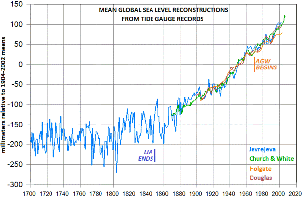
Man hört in der Presse immer wieder von einer Beschleunigung des Meeresspiegelanstiegs.
Betrachtet man die harten Messdaten, handelt es sich hierbei lediglich um das Wiederanfahren des Anstiegs im Übergang von der Kleinen Eiszeit zur Modernen Wärmeperiode.
Interessanterweise sah der IPCC dies in seinem ersten Bericht von 1990 ähnlich.
Dort heißt es:
Auf Basis von Untersuchungen lokaler Meeresspiegelentwicklungen sowie der globalen Meeresspiegelkurve gibt es keinen überzeugenden Hinweis auf eine Beschleunigung des globalen Meeresspiegels im 20. Jahrhundert.
-
IPCC First Assessment Report (FAR)
Climate Change: The IPCC Scientific Assessment (1990)
Chapter 9 - Sea Level Rise9.3.3 AccelerationsinSeaLevelRise
Is there evidence of any "accelerations" (or departures from long-term linear trends) in the rate of sea level rise? From examinations of both composite regional and global curves and individual tide gauge records, there is no convincing evidence of an acceleration in global sealevel rise during the twentieth century. For longerperiods, however, there is weak evidence for an acceleration over the last 2-3 centuries.
-
EIKE Europäisches Institut für Klima und Energie
2016-04-07 de Der Verlauf des Meeresspiegels im Holozän und seit 2.000 JahrenIn diesem Artikel wird die Datenlage zum Pegelverlauf der Weltmeere anhand von Literaturbeispielen gesichtet und vergleichend dargestellt.
Dabei geht es nicht darum, einen wahren Verlauf zu finden oder die Ursachen dafür zu erklären.
Viel mehr soll anhand der Variation an Studienergebnissen aufgezeigt werden, wie wenig auch dieses Thema wirklich "settled" ist und wie berechtigt "sichere Aussagen" dazu in Frage gestellt werden müssen.
-
Die kalte Sonne (Fritz Vahrenholt & Sebastian Lüning)
2014-01-21 de Weltklimarat IPCC in seinem Bericht von 1990: "Es gibt keine überzeugenden Hinweise darauf, dass sich der Meeresspiegelanstieg im 20. Jahrhundert beschleunigt hätte"
-
NoTricksZone (Pierre L. Gosselin)
2014-01-23 en German Review: Sea Level Rise Way Below Projections - No Hard Basis For Claims Of Accelerating RiseBy - 2014 IPCC 1990: "No convincing evidence that sea level rise accelerated in the 20th century"
-
Wattts Up With That? (Antony Watts)
2013-12-21 en Oh say can you see modern sea level rise from a geological perspective?
⇧ 2006
↑
Meeresspiegel - Tatsachen
en Sea level - Reality
fr Niveau des océans - La réalité
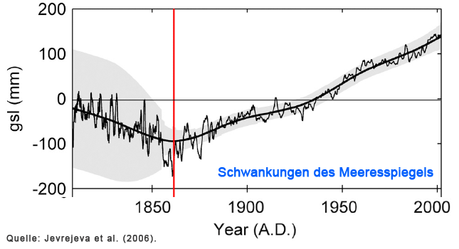
-
Erklärungen und Quellenangaben
Wasserplanet de Pole, Gletscher, MeeresspiegelFür den Anstieg der Meeresspiegel wurde bisher immer das Abschmelzen der Pole angeführt.
Tatsächlich wurde es in der Arktis wärmer und die Sommer dort länger jedoch in der Antarktis kälter.
Den Beweis, dass die seit ca. 1965 beobachtete Schmelze des arktischen Eises natürliche Ursachen hat, nämlich die Verlängerung der arktischen Sommer lieferten 2003 Seymour Laxon, Nell Peacock & Doug Smith.
Den Beweis, dass es derzeit keine grösseren Meersspiegelanstiege gibt, liefert eine aktuelle Zusammenfassung der INQUA Commission on Sea Level Changes and Coastal Evolution aller verfügbaren Daten bezüglich Meeresspiegel "A History and Projection of Global Sea Level" von Moerner et al. 2004.
Darin wird eindeutig nachgewiesen, dass es seit ca. 150 Jahren KEINEN Trend zu einer beschleunigten Meeresspiegelerhöhung gibt im Gegensatz zu den Aussagen IPCC!
Fazit: Es gibt ausser den natürlichen Schwankungen keinen anthropogen verursachen Anstieg der Meeresspiegel!
⇧ 1999
↑ en Pacific Sea Level measurements
-
john-daly.com
1999-09-22 en Pacific Sea LevelThe average for the Australian coast acc. to the National Tidal Facility in Adelaide (excluding Adelaide itself which is is known to have a major sinkage) is for a sea level rise of only +0.15 mm/yr.
That compares with IPCC claims of +3.0 mm/yr.
↑
Teil 3: Meeresspiegelprognosen
en Prognostics
fr Prévisions
- de Europäisches Forschungskonsortium verwirft extreme Meeresspiegelprognosen
- de "Die Ergebnisse geben uns eine gewisse Planungssicherheit für den Küstenschutz"
- en Observed mean sea level changes around the North Sea coastline from 1800 to present
↑ Europäisches Forschungskonsortium verwirft extreme Meeresspiegelprognosen
-
Die kalte Sonne (Fritz Vahrenholt & Sebastian Lüning)
2013-05-30 de Europäisches Forschungskonsortium verwirft extreme Meeresspiegelprognosen
-
European Framework-7 Programme Ice2sea
en
From Ice to High Seas: Sea-level rise and European coastlines
↑ "Die Ergebnisse geben uns eine gewisse Planungssicherheit für den Küstenschutz"
-
Universität Siegen
2013-07-18 de "Die Ergebnisse geben uns eine gewisse Planungssicherheit für den Küstenschutz"Dr. Thomas Wahl von der Universität Siegen publizierte gemeinsam mit einem europäischen Konsortium eine Studie zur Veränderung des Mittleren Meeresspiegels an der gesamten Nordsee.
Er fand anhand der erhobenen Daten heraus, dass der Meeresspiegel in diesem Bereich um ca. 1,7 mm pro Jahr im letzten Jahrhundert angestiegen ist.
Jensen: "Das steht in gutem Kontext zum globalen Mittleren Meeresspiegelanstieg."
Dass diese Schlussfolgerung derart exakt ausfällt, liegt an der mittlerweile stattlichen Datenmenge, die es ermöglicht, den Mittleren Meeresspiegel genau zu berechnen.
So liegen zum einen sehr lange Aufzeichnungen von Tidepegeln vor, die seit hunderten von Jahren entlang der Küste installiert sind und Wasserstandsveränderungen aufzeichnen.
Zum anderen stehen seit Anfang der 1990er Jahre satellitengestützte Informationen zu Änderungen der Meeresoberfläche, so genannte Altimeterdaten vor.
Die Fülle an verfügbaren Informationen erlaubt es Wissenschaftlern heutzutage auch, die unterschiedlichen Ursachen für die beobachteten Änderungen besser zu quantifizieren.
So besitzt Wasser seine größte Dichte bei 4° C. Jensen: "Wenn das Wasser wärmer wird, braucht es mehr Platz."
Steigt der Mittlere Meeresspiegel nach Berücksichtigung der Einflüsse von Wind und Luftdruck, gibt es eine direkte Ursachenverbindung zwischen Dichteeffekt und Klimaveränderung.
Aber auch die Absenkung von Küstenbereichen kann zum lokalen Anstieg des Meeresspiegels führen.
Ursachentrennung ist daher unabdingbar für valide Rückschlüsse.
↑ Observed mean sea level changes around the North Sea coastline from 1800 to present
-
ScienceDirect
2013-09 en Observed mean sea level changes around the North Sea coastline from 1800 to present
zzzzzzzzzzzzzzzzzzzzzzzzzzzzzzzzzzzzzzzzzzzzzzzzzzzzzzzzzzzzzz
-
de
Weltklimarat IPCC in seinem Bericht von 1990:
"Es gibt keine überzeugenden Hinweise darauf, dass sich der
Meeresspiegelanstieg im 20. Jahrhundert beschleunigt hätte"
en German Review: Sea Level Rise Way Below Projections - No Hard Basis For Claims Of Accelerating Rise - IPCC 1990: "No convincing evidence that sea level rise accelerated in the 20th century" - Spekulationen widerlegt
- Meeresspiegel - Tatsachen
- Meeresspiegel in der Adria stagnierte während Kältephasen und beschleunigte sich während Wärmephasen
- Pacific Sea Level measurements
- In der Antike lag Ephesos (Türkei) direkt am Meer
- Polare Eisschilde stabiler als gedacht, Meeresspiegelanstieg weniger dramatisch als befürchtet
eeeeeeeeeeeeeeeeeeeeeeeeeeeeeeeeeeeeeeeeeeeeeeeeeeeeeeeeeeeee
↑
Teil 4: Einluss der Sonne
en Solar impact
fr Impact du soleil
↑ a Sea level rise and solar cycles
⇧ 2012
↑ en Quantifying Sea Level Fall
-
Wattts Up With That? (Antony Watts)
2012-02-03 en Quantifying Sea Level Fall
⇧ 2009
↑ en Archibald on sea level rise and solar cycles
-
Wattts Up With That? (Antony Watts)
2009-04-07 en Archibald on sea level rise and solar cycles
Sea Level Rise and Solar Cycles

The saw tooth pattern reminded someone of the solar cycles and he overlaid it.
The correlation is striking.
The reason the Earth came out of the Little Ice Age is because we had a more active Sun, more active than at any time for the previous 8,000 years.
Holgate determined that 70% of the sea level rise of the 20th century was due to thermal expansion of the oceans and the rest due to melting glaciers.
Now that the Sun has become less active, that will work in reverse.
↑ b Sea Level Rise and Solar Activity
de Verzeichnis en Contents fr Sommaire
- 2018
- de
Der Levermann Skandal im deutschen Bundestag
"Es gibt keinen Beweis, dass CO2 einen großen Effekt auf das Klima hat".
Seine Folie zeigt die Schwankungen des Meeresspiegels im Einklang mit der Sonnenaktivität. - 2017
- en Closely Coupled: Solar Activity and Sea Level
- en Thus It Begins
- 2012
- de F10.7 Flux, Sea Level and the Holocene
- 2010
- en Sea Level Rise and Solar Activity
de Text en Text fr Texte
⇧ 2018
↑ Der Levermann Skandal im deutschen Bundestag
-
EIKE Europäisches Institut für Klima und Energie
Prof. Dr. Horst-Joachim Lüdecke und Dipl.-Ing. Michael Limburg
2018-12-12 de Der Levermann Skandal im deutschen BundestagVideoausschnitt der Auftritte von Prof. Anders Levermann, PIK und Prof. Nir Shaviv, Racah Institut of Physics Jerusalem, anlässlich des Fachgespräches zur COP 24 am 28.11.18 im Deutschen Bundestag.
"Es gibt keinen Beweis, dass CO2 einen großen Effekt auf das Klima hat".
Seine Folie zeigt die Schwankungen des Meeresspiegels im Einklang mit der Sonnenaktivität.
Nir Shaviv, Professor und Chairman des Racah Instituts für Physik der Hebräischen Universität von Jerusalem

⇧ 2017
↑ en Closely Coupled: Solar Activity and Sea Level
-
Wattts Up With That? (Antony Watts)
David Archibald
2017-07-03 en Closely Coupled: Solar Activity and Sea Level
![]()
![]() Solar Cycles and Sea Level 1909 to 2000
Solar Cycles and Sea Level 1909 to 2000
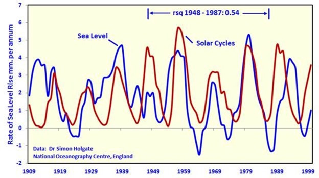
![]()
![]() Sea Level Change and Solar Activity 1948 to 1987
Sea Level Change and Solar Activity 1948 to 1987
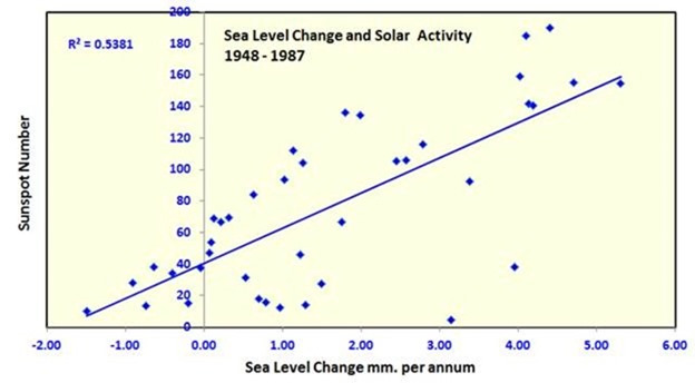
↑ en Thus It Begins
-
Wattts Up With That? (Antony Watts)
David Archibald
2017-07-01 en Thus It BeginsThe F10.7 index
F10.7 flux 2014 - 2017

Relative to the climate of the last century,
an F10.7 flux above 100 causes warming
and below that level causes cooling.
As of today, the F10.7 flux is 71, not far above the activity floor of 64.
Solar minimum is three years away and then we are likely to have at least two years of activity below 100 as activity rises into Solar Cycle 25.
Thus some of the heat that built up in the second half of the 20th century due to the highest solar activity in 8,000 years will have a chance to radiate into space.
Late spring frosts will become more frequent.
NOAA NATIONAL OCEANIC AND ATMOSPHERIC ADMINISTRATION
SPACE WEATHER PREDICTION CENTER
F10.7 CM RADIO EMISSIONS
The solar radio flux at 10.7 cm (2800 MHz) is an excellent indicator of solar activity.
Often called the F10.7 index, it is one of the longest running records of solar activity.
The F10.7 radio emissions originates high in the chromosphere and low in the corona of the solar atmosphere.
The F10.7 correlates well with the sunspot number as well as a number of UltraViolet (UV) and visible solar irradiance records.
The F10.7 has been measured consistently since 1947, first at Ottawa, and then at the Penticton Radio Observatory in British Columbia.
Unlike many solar indices, the F10.7 radio flux can easily be measured reliably on a day-to-day basis from the Earth's surface, in all types of weather.
Reported in "solar flux units", (s.f.u.), the F10.7 can vary from below 50 s.f.u., to above 300 s.f.u., over the course of a solar cycle.
The F10.7 Index has proven very valuable in specifying and forecasting space weather.
Because it is a long record, it provides climatology of solar activity over six solar cycles.
Because it comes from the chromosphere and corona of the sun, it tracks other important emissions that form in the same regions of the solar atmosphere.
The Extreme UltraViolet (EUV) emissions that impact the ionosphere and modify the upper atmosphere track well with the F10.7 index.
Many Ultra-Violet emissions that affect the stratosphere and ozone also correlate with the F10.7 index.
And because this measurement can be made reliably and accurately from the ground in all weather conditions, it is a very robust data set with few gaps or calibration issues.
| de | en | fr |
|---|---|---|
|
Die Sonne Sonnenaktivität |
The Sun Solar Activity |
Le soleil Activité solaire |
⇧ 2012
↑ en F10.7 Flux, Sea Level and the Holocene
-
2012-09-15 en F10.7 Flux, Sea Level and the Holocene
⇧ 2010
↑ en Sea Level Rise and Solar Activity
-
Wattts Up With That? (Antony Watts)
David Archibald
2010-12-01 en Sea Level Rise and Solar Activity
![]()
![]() Sea Level Rise and Solar Activity
Sea Level Rise and Solar Activity

en Successful prediction of levels of solar activity suggests that prediction of other phenomena driven by solar activity might also be successful, and useful.
Sea level rise is a concern of some people.
President Obama said in June 2008 that his nomination in the Democratic primaries was "the moment when the rise of the oceans began to slow".
The graph shows the satellite data from the University of Colorado from late 1992.
A change of trend is evident in 2004.
Prior to that, sea level was rising at 4.2 mm/annum, and after 2004 at 1.5 mm/annum.
2003 was the recent peak in solar activity in terms of flares, F10.7 flux and proton flux.
It is likely that the lower rate of rise post 2004 is due to lower subsequent solar activity.
↑
Teil 5: Einluss der Ozeanischen Oszillationen
en Impact of the Ocean oscillations
fr Impact des oscillations océaniques
| de | en | fr |
|---|---|---|
|
Klimawandel: Wissenschaft Ozeanzyklen & Ozeanische Oszillationen |
Climate change: Science Ocean Cycles & Ocean Oscillations |
Changement climatique: Science Cycles et oscillations océaniques |
| Ozeanzyklen steuern das Klima / El Niño (der Knabe/warm) & La Niña (das Mädchen/kalt) / ENSO: El Niño-Southern Oscillation / AMO: Atlantic Multidecadal Oscillation / NAO: North Atlantic Oscillation / AO: Arctic Oscillation / IOD: Indischer Ozean Dipol / PDO: Pacific decada oscillation | ||
↑ La Ola im Ozean: Die klimazyklische Stadionwelle
![]()
![]() Die Pazifisch Dekadische Oszillation (PDO) besitzt eine
Zyklendauer von ca. 60 Jahren.
Die Pazifisch Dekadische Oszillation (PDO) besitzt eine
Zyklendauer von ca. 60 Jahren.

Die Pazifisch Dekadische Oszillation erhöht bzw. erniedrigt die Temperatur um jeweils etwa 0,2°C je nach PDO-Phase.
Der Erwärmungsstop im Jahr 2000 fällt mit dem Abstieg der PDO zusammen und stellt eine Wiederholung der Situation aus den 1940er Jahren dar
Aber es gibt ja nicht nur die PDO, sondern eine ganze Flöte von weiteren klimasysteminternen Zyklen.
Nehmen wir zum Beispiel die AMO. Auch sie besitzt einen etwa 60-jährigen Zyklus, der jedoch um 10-20 Jahre zeitverzögert zur PDO abläuft.
Und auch die Nordatlantische Oszillation (NAO) schwingt in diesem Größenmaßstab.
Ist es nicht verwunderlich, dass all diese Zyklen in ähnlichen Zeitmaßstäben schwingen, wenn auch nicht synchron?
-
Die kalte Sonne (Fritz Vahrenholt & Sebastian Lüning)
2012-07-28 de La Ola im Ozean: Die klimazyklische Stadionwelle
![]()
![]() Temperaturzyklen sind dem Langzeittrend überlagert.
Temperaturzyklen sind dem Langzeittrend überlagert.

Die Temperaturprognose aus dem 2007er IPCC-Bericht folgt offensichtlich der durch die Ozeanzyklen übersteilten Flanke, wäre jedoch besser dem Langzeittrend gefolgt.
Der Langzeittrend wird zudem vermutlich in Kürze für eine Weile abknicken, da die Sonnenaktivität als wichtige Einflussgröße in den kommenden Jahrzehnten abnehmen wird.
-
Die kalte Sonne (Fritz Vahrenholt & Sebastian Lüning)
2012-06-19 de Wu et al. 2011: Erwärmung im späten 20. Jahrhundert durch Ozeanzyklen verstärkt
↑
Sechzig-Jahres-Ozeanzyklus jetzt auch in der Meeresspiegelentwicklung
gefunden
en Is There a 60-Year Oscillation in Global
Mean Sea Level?
![]()
![]()
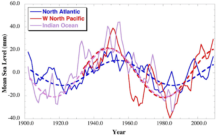
de Die Meeresspiegelentwicklung des letzten Jahrhunderts ist durch einen ausgeprägten 60-Jahres-Zyklus geprägt.
Auch das Ende der Erwärmung 1940 und 2000 lag wiederum 60 Jahre auseinander.
en We find that there is a significant oscillation with a period around 60-years in the majority of the tide gauges examined during the 20th Century, and that it appears in every ocean basin.
-
Die kalte Sonne (Fritz Vahrenholt & Sebastian Lüning)
2012-09-20 de Sechzig-Jahres-Ozeanzyklus jetzt auch in der Meeresspiegelentwicklung gefundenWenn man die Temperaturentwicklung der letzten gut hundert Jahre anschaut muss man sich fast ein wenig wie der berühmte Alfred Wegener fühlen:
Deutlich zeichnet sich in den Daten ein Zyklus ab, der etwa 60 Jahre umfasst.
So begannen die beiden jüngsten Erwärmungsepisoden gegen 1915 und 1975, also im Abstand von 60 Jahren.
Aber auch das Ende der Erwärmung 1940 und 2000 lag wiederum 60 Jahre auseinander.
Der Weltklimarat kann sich mit dieser zyklischen Eigendynamik des Klimas so gar nicht anfreunden.
Anstatt den Ozeanzyklus als steuernde Größe anzuerkennen, denkt sich das Gremium allerlei wackelige Hilfskonstruktionen aus, nur um den deutlichen Herzschlag der Natur nicht in die Temperaturprognosen einbauen zu müssen.
Und die Quittung kam prompt: Keines der ehemals so hochgelobten IPCC-Modelle hat den seit nunmehr 14 Jahren andauernden Erwärmungsstop vorhergesagt.
Warum sträubt sich der IPCC so sehr gegen eine sinnhafte Einbeziehung der Ozeanzyklen?
Es spricht viel dafür, dass ein gewichtiger Teil der Erwärmungsepisode von 1977-2000 auf das Konto der aufstrebenden Ozeanzyklen geht.
Denn genau in dieser Zeit stieg auch die Pazifisch Dekadische Oszillation (PDO) stark an und verharrte dann auf einem warmen, hohen Plateau.
Die Mitwirkung der Ozeanzyklen würde damit automatisch die Klimakraft des CO2 schwächen.
Kritik am CO2 hingegen ist beim IPCC unerwünscht und wird mit allen Mitteln unterdrückt.
Aus der Kurzfassung
Wir haben lange Datenreihen von Küstenpegeln in allen Ozeanbecker der Erde untersucht, um zu überprüfen, ob sich in der globalen Meeressiegelentwicklung ein etwa 60-Jahre langer Zyklus wiederfinden lässt, und ob es sich um einen wirklich global wirkenden Zyklus oder nur ein Artefakt in einer kleinen Anzahl von Pegeln handelt.
Wir fanden, dass in der Tat eine bedeutende Oszillation mit einer Periode von etwa 60 Jahren in der überwiegenden Mehrheit der untersuchten Küstenpegel während des 20. Jahrhunderts existiert, und dass diese in jedem Ozean der Erde auftritt.
Mittelt man die Küstenpegel für die einzelnen Ozeanbecken, so zeigt sich, dass sich die Phase und Amplitude der Zyklik im Nordatlantik, westlichen Nordpazifik und Indischen Ozean stark ähneln.
Im westlichen Südpazifik hingegen setzt die Entwicklung um etwa 10 Jahre verzögert ein.
Die einzige untersuchte Region, in der kein deutlicher 60-Jahreszyklus im Meeresspiegel existiert, ist der zentrale und östliche Nordpazifik.
Die in den Küstenpegeldaten identifizierte Phase des 60-Jahres-Zyklus ist so ausgebildet, dass sich der Meeresspiegel im Nordatlantik, westlichen Nordpazifik und Indischen Ozean seit etwa 1985-1990 zusätzlich angehoben hat.
Leider gibt es in Bezug auf die zeitliche als auch räumliche Abdeckung noch nicht genügend Küstenpegeldaten, um den 60-Jahreszyklus in der Meeresspiegelentwicklung zweifelsfrei nachweisen zu können.
Dennoch sollte der Zyklus berücksichtigt werden, wenn es um Betrachtungen zur Beschleunigung des Meeresspiegelanstiegs und die regionale Meeresspiegelentwicklung geht.
Aus dem Diskussionsabschnitt
Bis wir nicht vollständig verstanden haben, ob die Meeresspiegelentwicklung im Zeitraum von mehreren Jahrzehnten durch charakteristische Umbiegepunkte oder einen 60-Jahres-Zyklus geprägt wird und sich dies global auswirkt, sollte man mit Berechnungen eines beschleunigten Meeresspiegelanstiegs sehr vorsichtig sein.
Ausnahmen wären, wenn die verwendeten Datenreihen länger als zwei Zyklenperioden sind oder das Modell die Möglichkeit einer 60-Jahres-Oszillation bereits berücksichtigt.
Diese Einschränkungen gelten insbesondere für die Interpretation eines beschleunigten Meeressiegelanstiegs unter Verwendung von Satellitendaten, die lediglich 20 Jahre zurückreichen sowie für einzelne Pegel mit kurzen Datenreihen.
-
GEOPHYSICAL RESEARCH LETTERS
Don P. Chambers, Mark A. Merrifield, R. Steven Nerem
2012-08-17 en Is There a 60-Year Oscillation in Global Mean Sea Level?We examine long tide gauge records in every ocean basin to examine whether a quasi 60-year oscillation observed in global mean sea level (GMSL) reconstructions reflects a true global oscillation, or an artifact associated with a small number of gauges.
We find that there is a significant oscillation with a period around 60-years in the majority of the tide gauges examined during the 20th Century, and that it appears in every ocean basin.
Averaging of tide gauges over regions shows that the phase and amplitude of the fluctuations are similar in the North Atlantic, western North Pacific, and Indian Oceans, while the signal is shifted by 10 years in the western South Pacific.
The only sampled region with no apparent 60-year fluctuation is the Central/Eastern North Pacific.
The phase of the 60-year oscillation found in the tide gauge records is such that sea level in the North Atlantic, western North Pacific, Indian Ocean, and western South Pacific has been increasing since 1985-1990.
Although the tide gauge data are still too limited, both in time and space, to determine conclusively that there is a 60-year oscillation in GMSL, the possibility should be considered when attempting to interpret the acceleration in the rate of global and regional mean sea level rise.
↑ Meeresspiegelentwicklung der letzten 150 Jahre eng an natürliche Ozeanzyklen gekoppelt
-
Die kalte Sonne (Fritz Vahrenholt & Sebastian Lüning)
2013-06-02 de Meeresspiegelentwicklung der letzten 150 Jahre eng an natürliche Ozeanzyklen gekoppelt
↑ Meeresspiegelentwicklung im tropischen Pazifik folgt natürlichen Zyklen
-
Die kalte Sonne (Fritz Vahrenholt & Sebastian Lüning)
2012-02-12 de Meeresspiegelentwicklung im tropischen Pazifik folgt natürlichen Zyklen
↑
Teil 6: Grundwasserbeitrag am Meeresspiegelanstieg
en Impct of groundwater pumping on sea-level change
fr Impact du pompage d'eau sur le niveau des oceans
↑
Neue Arbeit in Nature Geoscience: Grundwasserbeitrag am
Meeresspiegelanstieg größer als bislang vermutet
en Source found for missing water in sea-level rise
-
Die kalte Sonne (Fritz Vahrenholt & Sebastian Lüning)
2012-07-13 de Neue Arbeit in Nature Geoscience: Grundwasserbeitrag am Meeresspiegelanstieg größer als bislang vermutetDer Meeresspiegel steigt, dies ist unbestritten. Jedes Jahr kommen momentan etwa 1,8 mm dazu.
Und das ist auch wenig verwunderlich, denn wir befinden uns in einer klimatisch warmen Phase - der Modernen Wärmeperiode - die kräftig an den großen Eisschilden in den Polargebieten sowie den vielen Gebirgsgletschern nagt.
Das hier produzierte Schmelzwasser gelangt dann ins Meer.
Aber die warmen Temperaturen besorgen noch einen zweiten Effekt. Warmes Wasser nimmt nämlich mehr Platz ein als kaltes, so dass sich das Volumen des in den Ozeanen gespeicherten Meerwassers erhöht.
Da das Ozeanbecken nach unten und zu den Seiten begrenzt ist, kann sich der Wasserkörper nur nach oben ausdehnen und trägt so ebenfalls seinen Teil zum Meeresspiegelanstieg bei.
Die entsprechenden Anteile von Eisschmelze und Wasserausdehnung kann man berechnen, und genau dies hat der Weltklimarat in seinem letzten Bericht von 2007 auch getan. Überraschenderweise kamen die Forscher jedoch nicht auf einen Meeresspiegelanstieg von 1,8 mm pro Jahr, sondern nur auf 1,1 mm.
Irgendetwas schien also noch zu fehlen.
Nun scheint das Rätsel gelöst und die fehlenden 0,7 mm pro Jahr gefunden zu sein.
-
Focus
2012-05-20 de Nicht nur Klima und Polkappen sind Ursache
Rätsel gelöst: Warum der Meeresspiegel so rasant steigt
Der Meeresspiegel steigt jährlich um etwa 1,8 Millimeter.
Bisher konnten davon mit Klimaerwärmung und dem Abschmelzen der Polkappen jedoch nur 1,1 Millimeter erklärt werden.
Aber wo kommen die restlichen Wassermassen her? Dieses Rätsel scheint jetzt gelöst zu sein.
Grund für den Anstieg der vergangenen Jahrzehnte sei neben dem Klimawandel vor allem die massive Nutzung von Grundwasser.
Die Wissenschaftler wollen das letzte Puzzlestück zum Mysterium "steigender Meeresspiegel" gefunden haben.
Das Grundwasser, so die These, werde aus unterirdischen Flüssen, Seen oder anderen Reservoirs abgepumpt und gelange so in die Ozeane.
Die Reserven im Boden würden hingegen nicht mehr aufgefüllt.
-
Welt Online
2012-05-20 de Abgepumptes Grundwasser hebt den Meeresspiegel
-
Augsburger Allgemeine
2012-05-21 de Klimaforscher: Rätsel um steigenden Meeresspiegel gelöst
-
Nature
2012-05-20 en Source found for missing water in sea-level riseDuring the latter half of the twentieth century, global sea level rose by about 1.8 millimetres per year, according to data from tide gauges.
The combined contribution from heating of the oceans, which makes the water expand, along with melting of ice caps and glaciers, is estimated to be 1.1 millimetres per year, which leaves some 0.7 millimetres per year unaccounted for.
This gap has been considered an important missing piece of the puzzle in estimates for past and current sea-level changes and for projections of future rises.
It now seems that the effects of human water use on land could fill that gap.
A team of researchers reports in Nature Geoscience that land-based water storage could account for 0.77 millimetres per year, or 42%, of the observed sea-level rise between 1961 and 2003.
Of that amount, the extraction of groundwater for irrigation and home and industrial use, with subsequent run-off to rivers and eventually to the oceans, represents the bulk of the contribution.
-
Junk Science
2012-06-06 en Looking at the Cause of Global Seal Level Rises
de Panik-Küche en Panic laboratory fr Marmite alarmiste
-
SciLogs / Stefan Rahmstorf
2012-05-31 de Was lässt den Meeresspiegel steigen?
↑
Teil 7: Panikmache und Realität
en Panic and Reality
fr Panique et réalité
- Panikmeldungen
- Panikmeldungen
- Realität
- Realität
- Panik-Angaben des IPCC
- Panik-Angaben des IPCC werden immer kleiner
- "Untergehende" Regionen
- Bangladesch
- Korallen-Atolle (Pacific Islands)
- Fidschi / Fiji / Fidji (Südpazifik)
- Kiribati (Pacific Islands)
- Tuvalu (Pacific Islands)
- Salomonen-Inseln (Pacific Islands)
- Takuu
- Malediven (Indischen Ozean, westlich von Sri Lanka)
- Totope (Ghana)
- Talpatti
- Manila (Philippinen)
- Panama Inseln
- Webseiten
- 2018
- de Flashcrash Klimaalarm. Wer Klimaalarm posaunt, bekommt immer recht (Teil 1)
- 2017
- de Crashinformation zu den "untergehenden" Pazifikinseln
- de Land unter im Norden ab 2050 - oder: Pünktlich zur Tagung des UN-Klimasekretariats in Bonn steigt der (simulierte) Meeresspiegel verstärkt
- de Südseeträumereien: Märchenstunde mit Onkel Schellnhuber
- en Recent Sea-Level Change at Major Cities
- 2016
- Landgewinn trotz Meeresspiegelanstieg
- 2015
-
Südseeatolle: Noch keine der betroffenen Inseln ist in nächster Zeit
von Überflutung bedroht.
Einige vergrößern sich sogar auf Grund natürlicher ökologischer Vorgänge
Video: Land unter
- de Flussdeltas in Indien und Bangladesch saufen wegen Sedimentverfestigung ab
- 2014
- Fachzeitschrift 'Climate of the Past' lehnt Meeresspiegel-Manuskript von Rahmstorf-Gruppe ab: Gutachter finden fundamentale Fehler in der Methodik
- Südseeinseln trotzen dem Meeresspiegelanstieg: UNO weist Klimaschadensersatzansprüche der pazifischen Inselstaaten ab
- Allianz der kleinen Inselstaaten will ans Klimageld ran
- Österreichische Tageszeitung 'Die Presse': Das Klima lässt die Pazifikatolle nicht untergehen!
- Medshild and Redshild dam against sea level rising in the mediterranean sea
- 2013
- Das Tessin liegt praktisch am Meer
- Fragwürdige Finte: Neuer IPCC-Bericht behauptet Verschärfung des Meeresspiegelanstiegs, während neue Studien das genaue Gegenteil fanden
- 2012
- de
Senat von North Carolina erteilt Rahmstorfs beschleunigtem Meeresspiegel
eine Absage
en Science vs AGW Advocacy in North Carolina - Nachträgliche Korrekturen der Satelliten-Meeresspiegeldaten: Was nicht passt wird passend gemacht?
- Pünktlich zum UN-Klimafest in Doha: Neuer Alarm aus Potsdam
- 2010
- de Überraschendes Insel-Wachstum
- 2008
- Obama lässt Meeresspiegel senken ...
- 2000
- Entschädigung für die "untergehenden" Inseln
⇧ Panikmeldungen
↑
Panikmeldungen
en Panic
fr Panique
2015
-
Tages-Anzeiger
2015-11-09 de «Steigender Meeresspiegel lässt unser Land verschwinden»Der Meeresspiegelanstieg gefährdet etwa eine halbe Milliarde Menschen weltweit - darunter auch Europäer.
Eine Klimaerwärmung um 4 Grad Celsius wird einer neuen Studie zufolge weltweit 470 bis 760 Millionen Menschen in Küstenregionen gefährden.
Aufbauend auf einer im Oktober veröffentlichten Studie mit Daten für die USA legt die US-Forschungsorganisation Climate Central in ihrer Untersuchung nun interaktives Kartenmaterial für die gesamte Welt vor.
Am stärksten trifft es demnach China, wo 145 Millionen Menschen in überflutungsbedrohten Regionen leben.
Dort wäre auch der Effekt einer Erwärmung um nur 2 Grad am höchsten: Dann wären nur noch 64 Millionen Menschen gefährdet.
In zwölf weiteren Nationen - darunter Indien, Bangladesh und Vietnam - müssten jeweils mehr als 10 Millionen Menschen dem Wasser weichen.
Zu den zehn am meisten gefährdeten Megastädten zählen Shanghai, Hongkong, Kalkutta und Mumbai.
Auf interaktiven Karten können die verschiedenen Szenarien für alle Regionen der Welt betrachtet werden.
Selbst in europäischen Ländern mit Meeresküste wie Italien, Spanien, Frankreich oder Deutschland wären demnach auch bei einem 2-Grad-Plus jeweils zwischen 1,5 und 2,8 Millionen Menschen gefährdet.
2010
-
Pensée unique
2010-08-01 fr Encore une nouvelle rassurante
2009
-
Pensée unique
2009-07-24 fr "Sale temps pour la planète"
France 5 nous a infligé le 21 Juillet 2009 un plaidoyer vidéo larmoyant et sentencieux, réalisé en 2007, sur la peur panique qu'éprouveraient des malheureux habitants des îles Tuvalu qui, nous dit-on, auraient commencé à fuir en masse leurs atolls menacés d'engloutissement (selon des "experts").Tout cela, bien entendu à cause du 'réchauffement' changement climatique (anthropique, cela va de soi).
2008
-
News Busters
2008-11-17 en Scare-Mongering on Steroids: NBC Warns Oceans Could Rise 200 Feet!Forget Al Gore's measly 20-foot (6m) sea level rise from "An Inconvenient Truth."
Oceans Could Rise 200 Feet (60m) !
-
Extrem Wetter Kongress in Hamburg
2008 de "Experten auf dem gehen davon aus, dass die Arktis ab 2050 im Sommer eisfrei sein wirdÜber dreissig Meteorologen, Klimatologen, politische Experten der Bundesregierung und Medienvertreter haben über die Gefahren bei extremen Wetterbedingungen referiert und diskutiert.
Eine große Gefahr stellt das Abschmelzen der Polargebiete sowie des grönländischen Eises dar, das zu einem Meeresspiegelanstieg von bis zu 7 m führen kann.
Claudia Hangen - Heise Online/Telepolis
2008-03-29 de Arktisches Eis schmilzt immer schneller
2007
-
Schweizer Fernsehen
2007-02-06 de
Tuvalu wird untergehen
(oder auch nicht, siehe Tuvalu - Pacific Islands und Kohlendioxid und Klima)
⇧ Realität
↑
Realität
en Reality
fr Réalité
de Verzeichnis en Contents fr Sommaire
- 2011
- de The great sea-level humbug: There is no alarming sea level rise!
- 2007
- de
Experten warnen vor Al Gore und dem Klimaschwindel
- en
Al Gore Finds Truth Inconvenient
- 2006
- en
Inconvenient Truths for Al Gore - 4: Moulins (Gletschermühlen)
de Text en Text fr Texte
⇧ 2011
↑ en The great sea-level humbug: There is no alarming sea level rise!
-
Nils-Axel Mörner
2011-01 en The great sea-level humbug: There is no alarming sea level rise!While the IPCC and its boy scouts present wilder and wilder sea level predictions for the near future, the real observational facts demonstrate that sea level has remained virtually stable for the last 40-50 years.
⇧ 2007
↑ Experten warnen vor Al Gore und dem Klimaschwindel
↑ en Al Gore Finds Truth Inconvenient
-
2007-04-28 en
Al Gore Finds Truth Inconvenient
⇧ 2006
↑ en Inconvenient Truths for Al Gore - 4: Moulins (Gletschermühlen)
⇧ Panik-Angaben des IPCC werden immer kleiner
↑ Panik-Angaben des IPCC werden immer kleiner
Die Panik-Angaben des IPCC werden immer kleiner
"Anthropogener" Meeresspiegelanstieg?
Die IPCCPrognosen passen sich mehr und mehr der Realität von ca. 20 cm/Jahrhundert an.
![]()

Aussage betreffend Anstieg des Meeresspiegels:
- 1990 prognoszitierte der Welt-Klimarat einen Anstieg des Meeresspiegels von von über 60 cm. Einige Jahre später waren es 50 cm und heute spricht der Klimarat von nur noch über 30 cm.
-
ARD München de
IPCC zensiert Klimawissenschaftler Klimaschwindel
- Pensée unique fr Le bêtisier
⇧ "Untergehende" Regionen
↑ Bangladesch
- Allgemein
- 2016
- de Wasserführung des Ganges unterlag schon immer natürlichen Schwankungen
- 2015
- de Flussdeltas in Indien und Bangladesch saufen wegen Sedimentverfestigung ab
- 2012
- de Bangladesch und die Pazifikinseln wachsen trotz steigendem Meeresspiegel
- 2010
- de Die Insel Talpatti im Golf von Bengalen - Die Insel des Weltuntergangs!
- 2008
- de
Bangladesch taucht auf und wird größer!
en Bangladesch emerges and gets greater!
fr Bangladesch émerge et devient plus grand!
⇧ Allgemein
-
Wikipedia
de
Bangladesch
en Bangladesh
fr Bangladesh
⇧ 2016
↑ Wasserführung des Ganges unterlag schon immer natürlichen Schwankungen
-
Die kalte Sonne (Fritz Vahrenholt & Sebastian Lüning)
2016-04-03 de Wasserführung des Ganges unterlag schon immer natürlichen Schwankungen: Wasser-Minister von Bangladesch braucht dringend Nachhilfe in historischer Dürrekunde
⇧ 2015
↑ Flussdeltas in Indien und Bangladesch saufen wegen Sedimentverfestigung ab
-
Die kalte Sonne (Fritz Vahrenholt & Sebastian Lüning)
2015-03-23 de Flussdeltas in Indien und Bangladesch saufen ab: N24 lässt Küstenabsenkung als Folge der Sedimentverfestigung als wichtigsten Grund unerwähntAbsinken von Deltas
Deltagebiete sind dafür bekannt, dass sie durch die allmähliche Verfestigung ihrer Sedimente - die sogenannte Kompaktion - absinken.
So berichtete 2013 der Geologe Till Hanebuth über Ergebnisse aus dem Deltabereich Bangladeschs.
Sein Team fand natürliche Absenkungsraten von mehr als 4 Millimeter pro Jahr.
Diese Rate ist deutlich höher als der klimatisch-bedingte Meeresspiegelanstieg.
⇧ 2012
↑ Bangladesch und die Pazifikinseln wachsen trotz steigendem Meeresspiegel
-
Die kalte Sonne (Fritz Vahrenholt & Sebastian Lüning)
2012-07-15 de Bangladesch und die Pazifikinseln wachsen trotz steigendem Meeresspiegel: Klimamodellierer benötigen dringend Nachhilfe in GeologieBangladesch wächst
Zum anderen könnte man ja einfach mal die Satellitendaten zurate ziehen und nachschauen, wie viel kostbares Land denn eigentlich jedes Jahr so in den Meeresfluten versinkt.
Genau dies haben 2008 Wissenschaftler vom Center for Environment and Geographic Information Services (CEGIS) in der Hauptstadt Dhaka bereits getan.
Hierzu werteten sie Satellitenbilder der letzten 32 Jahre aus.
Zu ihrer Überraschung fanden sie, dass Bangladeschs Fläche in dieser Zeit im Durchschnitt um 20 Quadratkilometer pro Jahr angewachsen ist.
Grund hierfür sind die enormen Schuttmassen des Himalaya, die von zahlreichen großen Flüssen wie etwa dem Ganges oder dem Brahmaputra quer durch das Land in Richtung des Indischen Ozeans transportiert werden.
Auf diese Weise wälzen sich jedes Jahr mehr als eine Milliarde Tonnen Sediment durch das Land, wovon ein großer Teil an der Küste des Landes im Golf von Bengalen schließlich liegen bleibt.
Durch dieses Aufsedimentieren kann sich Bangladesch selbst bei leicht steigendem Meeresspiegel weiter in Richtung Ozean ausdehnen.
Dieser Mechanismus ist in der geologischen Fachwelt bestens bekannt und läuft unter dem Begriff "Progradation" bzw. "early Highstand Systems Tract" (HST).
Die Klimamodellierer des IPCC haben es offensichtlich versäumt, diesen Prozess in ihre Überlegungen mit einzubeziehen, was ärgerlich ist.
Durch diesen Mechanismus sind in den letzten fünf Jahrzehnten etwa 1000 Quadratkilometer Neuland entstanden.
Der Leiter der CEGIS-Instituts, Maminul Haque Sarker, nimmt an, dass auch in den kommenden 50 Jahren weitere 1000 Quadratkilometer dazukommen.
Der steigende Meeressiegel verlangsamt dabei den Landzuwachs.
Würde es keinen Meeresspiegelanstieg geben, würde Bangladesch aber noch schneller wachsen.
Der Leiter des Bangladesh Water Development Board's Coastal Study and Survey Department, Mahfuzur Rahman, erklärte, dass dieser natürliche Landgewinnungsprozess durch den Bau von Dämmen sogar noch weiter beschleunigt werden könnte.
Dies geschah zum Beispiel bereits in größerem Umfang in den 1950er und 60er Jahren. Durch Dammbau könnten laut Rahman in der nahen Zukunft bis zu 5000 Quadratkilometer Land gewonnen werden.
An einigen Stellen ist aber auch in Bangladesch Land verlorengegangen. Diese Fälle haben jedoch eher mit der Erosion durch Flüsse zu tun, einem ganz normalen Prozess, den es immer gegeben hat.
Der natürliche Landzuwachse an der Küste hat diese Verluste jedoch mehr als wieder wettgemacht.
⇧ 2010
↑ Die Insel Talpatti im Golf von Bengalen - Die Insel des Weltuntergangs!
-
Wikipedia
de
South Talpatti
en New Moore, or South Talpatti
fr Île Sud Talpatti
![]()
![]()

Quelle / Source:
-
EIKE Europäisches Institut für Klima und Energie
Klaus-Eckart Puls
2010-03-27 de Die Insel des Weltuntergangs!Eine DPA-Meldung geistert durch die Medien:
Im Golf von Bengalen ist eine Insel namens Talpatti verschwunden.
Glaubt man den Medien, dann ist es ein erstes Signal, daß der nun dramatisch steigende Meersspiegel hiermit den Weltuntergang eingeläutet hat.
Schaut man allerdings etwas genauer hin
Zunächst einmal ist festzustellen, daß die genannte Insel im äußeren Mündungs- und Deltabereich der riesigen Ströme Ganges und Brahmaputra liegt.
Diese Flüsse transportieren jährlich Millionen Tonnen Sand und Schlamm in den Golf von Bengalen.
Die Folgen sind die gleichen wie zum Beispiel an der deutschen Nordseeküste:
Es entstehen und vergehen Sandbänke, Dünen und Inseln -
hier durch die Gezeiten-Ströme und die Nordsee-Orkane,
dort durch die großen Flüsse und die Zyklone.
Die Insel Talpatti (9 km2) hatte etwa die Größe der kleinen Frieseninsel Baltrum (7 km2).
Darüber hinaus ist festzustellen,
daß nach den Messungen der Satelliten-Radarsysteme TOPEX/POSEIDON die Meeresspiegel-Änderungen im Golf von Bengalen einerseits geringfügig und andererseits keineswegs einheitlich waren und sind, wie die Abbildung zeigt.
Schließlich ist darauf hinzuweisen,
daß sich die Regierung von Bangladesch energisch gegen die ständigen Behauptungen von Vertretern des IPCC zur Wehr setzen.
Seit Jahren hört man vom IPCC und seinen Instituten Horror-Prognosen zu überfluteten Küsten in aller Welt, insbesondere auch zu Bangladesch:
"...IPCC hat den Untergang von Bangladesch vorhergesagt,
...den Verlust von 17% seiner Landmasse bis 2050 aufgrund des Meeresspiegel-Anstieges infolge der globalen Erwärmung",und weiter a.a.O.: "Das Nobel-Preis-Träger-Gremium sagt, daß 20 Millionen Menschen in Bangladesch bis 2050 zu Umweltflüchtlingen werden, und daß das Land 30% seiner Nahrungsmittel-Produktion verlieren wird",
und weiter a.a.O.: "Der Direktor des NASA-Goddard-Instituts James Hansen zeichnet ein noch grauenhafteres Bild mit der Vorhersage, das ganze Land könnte bis zum Ende des Jahrhunderts unter Waser stehen".
Da hielt bisher auch das Potsdamer Institut PIK gut mit: "Schellnhuber etwa zeigt sich überrascht von der Dynamik des Klimawandels und sieht "im schlimmsten Fall" einen Meeresanstieg von zwei Metern bis 2100 und eine "biblische Völkerwanderung" kommen.
Denn betroffen wären in den Küstenregionen 500 Millionen bis eine Milliarde Menschen.
Natürlich trifft es besonders die Ärmsten wie in Bangladesch".
Die Reihe derartiger Zitate ließe sich hier beliebig fortsetzen ...
Die Realität sieht offensichtlich und glücklicherweise(!!) ganz anders aus
"Neue Daten zeigen, daß Bangladesch's Landmasse zunimmt,
im Gegensatz zu den Vorhersagen, daß diese südasiatische Nation bis Ende des Jahrhunderts unter den Wellen verschwindet, wie "Experten" behaupten.
Wissenschaftler des Instituts für Umwelt und Geographie Dhaka haben Satelliten-Daten der letzten 32 Jahre ausgewertet und sagen, Bangladesch's Landmasse hat in dieser Zeit jährlich um 20 km2 zugenommen."
Seit 1973 summierte sich das erheblich und beachtlich:
"Satellitenbilder im Vergleich mit Landkarten zeigen seit 1973, daß rund 1000 km2 Land aus dem Meer entstanden sind".
Zwei Gründe zeichnen dafür verantwortlich:
- Die beiden großen Ströme Brahmaputra und Ganges transportieren ständig große Mengen Schwebestoffe stromabwärts, die sich im Delta ablagern,
-
Die vom IPCC seit 15 Jahren prognostizierte Beschleunigung des Meeresspiegel-Anstiegs findet nicht statt, sondern der Anstieg verlangsamt sich weltweit.
⇧ 2008
↑
Bangladesch taucht auf und wird größer!
en Bangladesch emerges and gets greater!
fr Bangladesch émerge et devient plus grand!
-
EIKE Europäisches Institut für Klima und Energie
Klaus-Eckart Puls
2008-08-05 de Aus dem Nebel der Klima-Hysterie: Bangladesch taucht auf und wird größer!Panikmeldungen
IPCC hat den Untergang von Bangladesch vorhergesagt, "den Verlust von 17% seiner Landmasse bis 2050 aufgrund des Meeresspiegel-Anstieges infolge der globalen Erwärmung"
Das Nobel-Preis-Träger-Gremium sagt, daß 20 Millionen Menschen in Bangladesch bis 2050 zu Umweltflüchtlingen werden, und daß das Land 30% seiner Nahrungsmittel-Produktion verlieren wird.
Der Direktor des NASA-Goddard-Instituts James Hansen zeichnet ein noch grauenhafteres Bild mit der Vorhersage, das ganze Land könnte bis zum Ende des Jahrhunderts unter Waser stehen.
Da hielt bisher auch das Potsdamer Institut PIK gut mit: Schellnhuber etwa zeigt sich überrascht von der Dynamik des Klimawandels und sieht "im schlimmsten Fall" einen Meeresanstieg von zwei Metern bis 2100 und eine "biblische Völkerwanderung" kommen.
Denn betroffen wären in den Küstenregionen 500 Millionen bis eine Milliarde Menschen.
Natürlich trifft es besonders die Ärmsten wie in Bangladesch
Realität
Die Realität sieht offensichtlich und glücklicherweise(!!) ganz anders aus, wie eine soeben in Dhaka vorgestellte Studie zeigt.
Wissenschaftler des Instituts für Umwelt und Geographie Dhaka haben Satelliten-Daten der letzten 32 Jahre ausgewertet und sagen, Bangladesch's Landmasse hat in dieser Zeit jährlich um 20 km2 zugenommen.
Seit 1973 summierte sich das erheblich und beachtlich: "Satellitenbilder im Vergleich mit Landkarten zeigen seit 1973, daß rund 1000 km2 Land aus dem Meer entstanden sind.
Zwei Gründe zeichnen dafür verantwortlich:
(1) Die beiden großen Ströme Brahmaputra und Ganges transportieren ständig große Mengen Schwebestoffe stromabwärts, die sich im Delta ablagern,
(2) Die vom IPCC seit 15 Jahren prognostizierte Beschleunigung des Meeresspiegel-Anstiegs findet nicht statt, sondern der Anstieg verlangsamt sich weltweit.
↑ Korallen-Atolle (Pacific Islands)
de Allgemein en General fr Générale
de Verzeichnis en Contents fr Sommaire
- 2016
- de
Das unsinkbare "Versinkende-Atolle"-Narrativ
en The Unsinkable "Sinking Atolls" Meme - 2007
- en DR. NILS-AXEL MÖRNER, Sea-level Expert: It's Not Rising!
de Text en Text fr Texte
⇧ 2016
↑
Das unsinkbare "Versinkende-Atolle"-Narrativ
en
The Unsinkable "Sinking Atolls" Meme
-
EIKE Europäisches Institut für Klima und Energie
2016-08-01 de Das unsinkbare "Versinkende-Atolle"-NarrativSchon zuvor habe ich über die Studie von Arthur Webb und Paul Kench geschrieben, und zwar hinsichtlich der Tatsache, dass Korallen-Atolle nicht vom steigenden Meeresspiegel verschluckt werden.
Ihre Schlussfolgerung in jener Studie lautete, dass aktuelle Messungen der zur Debatte stehenden Inseln direkt den Behauptungen widersprechen, denen zufolge sie versinken würden.
Die Messungen zeigten, dass die Inseln entweder an Größe zunahmen oder deren Größe zumindest gleich blieb
-
Watts UP With That? (Antony Watts)
2016-07-25 en The Unsinkable "Sinking Atolls" MemeI've written before about the study of Arthur Webb and Paul Kench regarding the fact that coral atolls are not being swallowed by rising seas.
Their conclusion in that study was that the claims of sinking atolls were contradicted by the actual measurements of the islands in question.
The measurements showed the islands were mostly either growing in size or staying the same
⇧ 2007
↑ en Sea-level Expert: It's Not Rising!
-
21st CENTURY Science & Technology / DR. NILS-AXEL MÖRNER
2007-07-25 en Sea-level Expert: It's Not Rising!Why coastal dwellers should not live in fear of inundation.
↑ Fidschi / Fiji / Fidji (Südpazifik)
de Allgemein en General fr Générale
-
Wikipedia
de FidschiFidschi, offiziell Republik Fidschi ist ein Inselstaat im Südpazifik nördlich von Neuseeland und östlich von Australien.
en Fiji
Fiji is an island country in Melanesia in the South Pacific Ocean about 1,100 nautical miles (2,000 km; 1,300 mi) northeast of New Zealand's North Island.
Its closest neighbours are Vanuatu to the west, New Caledonia to the southwest, New Zealand's Kermadec Islands to the southeast, Tonga to the east, the Samoas and France's Wallis and Futuna to the northeast, and Tuvalu to the north.
Fiji is an archipelago of more than 330 islands, of which 110 are permanently inhabited, and more than 500 islets, amounting to a total land area of about 18,300 square kilometres (7,100 sq mi).
The farthest island is Ono-i-Lau.
The two major islands, Viti Levu and Vanua Levu, account for 87% of the total population of 898,760.
The capital, Suva on Viti Levu, serves as Fiji's principal cruise port.
About three-quarters of Fijians live on Viti Levu's coasts, either in Suva or in smaller urban centres like Nadi (tourism) or Lautoka (sugar cane industry).
Viti Levu's interior is sparsely inhabited due to its terrain.
fr Fidji
Les Fidji ou les îles Fidji, en forme longue la république des Fidji est un pays d'Océanie situé dans l'océan Pacifique sud, à 744 km à l'ouest-nord-ouest des Tonga, à 788 km au sud-ouest de Wallis-et-Futuna et à 1 067 km au sud des Tuvalu.
de Verzeichnis en Contents fr Sommaire
- 2018
- de
«Diese Forscher haben eine politische Agenda»
Der Ozeanograph Nils-Axel Mörner stellt sich gegen den Weltklimarat und die Warnungen vor versinkenden Inseln. - 2017
- de
'Untergang' von Fidji ist Fake News von COP23 -
Offener Brief von Prof. Mörner
en Fiji 'Flooding' is Fake News from #COP23
de Text en Text fr Texte
⇧ 2018
↑ «Diese Forscher haben eine politische Agenda»
-
Basler Zeitung / Alex Reichmuth
2018-01-31 de «Diese Forscher haben eine politische Agenda»Der Ozeanograph Nils-Axel Mörner stellt sich gegen den Weltklimarat und die Warnungen vor versinkenden Inseln.
Herr Mörner, Sie waren in letzter Zeit mehrmals auf der Inselgruppe Fidschi im Südpazifik, um dort Veränderungen der Küsten und des Meeresspiegels zu erforschen.
Warum Fidschi?
Nils-Axel Mörner:
Ich wusste, dass es im Juni 2017 in New York eine Wissenschaftskonferenz gibt, die sich mit Meeresspiegel-Veränderungen auf Fidschi befasst.Und es war bekannt, dass der Inselstaat den Vorsitz der 23. Weltklimakonferenz haben wird, die im letzten November in Bonn stattfand.
Fidschi rückte also in den Fokus des Interesses.
Man hörte, dass der steigende Meeresspiegel dort schon viel Schaden angerichtet habe.
Ich wollte mit eigenen Augen überprüfen, ob das stimmt.
Was machte Sie skeptisch?
Ich habe mein ganzes Leben lang zu Veränderungen des Meeresspiegels geforscht und dazu 59 Länder bereist.Kaum ein anderer Forscher hat so viel Erfahrung auf diesem Gebiet.
Der Weltklimarat (IPCC) aber hat die Fakten zu diesem Thema immer schon falsch dargestellt.
Er übertreibt die Risiken eines Pegelanstiegs gewaltig.
Das IPCC stützt sich insbesondere auf fragwürdige Computermodelle statt auf Feldforschung ab.
Ich aber will immer wissen, was Sache ist.
Darum ging ich nach Fidschi.
⇧ 2017
↑
'Untergang' von Fidji ist Fake News von COP23 -
Offener Brief von Prof. Mörner
en
Fiji 'Flooding' is Fake News from #COP23
-
EIKE Europäisches Institut für Klima und Energie
Guest Blogger / Chris Frey
2017-11-22 de 'Untergang' von Fidji ist Fake News von COP23 - Offener Brief von Prof. Mörner
-
Watts UP With That? (Antony Watts) / Guest Blogger
2017-11-13 en Fiji 'Flooding' is Fake News from #COP23
↑ Kiribati (Pacific Islands)
- Allgemein
- 2018
- de
SOS Südsee - Der Ozean steigt nicht übernatürlich, dafür umso
stärker die Propaganda in der öffentlich-rechtlichen
Berichterstattung
Teil 1: Fiji und Tarawa, die Hauptinsel von Kiribati Fiji
Teil 2: Marshall-Inselgruppe - 2017
- de Fake News: Zuerst der SWR, nun der BR: Ein Südseeparadies versinkt im Meer. Öffentlich-Rechtliche Klimawandel-Agitation in Endlosschleife
- 2013
- de
Kapitel 8 - "Land unter" bei SRF-DOK? - 10 unbequeme Wahrheiten über
Hans J. Schellnhuber
- 2012
- de Kiribati geht unter - oder vielleicht doch nicht?
- 2010
- de Überraschendes Insel-Wachstum
⇧ Allgemein
⇧ 2018
↑
SOS Südsee - Der Ozean steigt nicht übernatürlich, dafür umso
stärker die Propaganda in der öffentlich-rechtlichen
Berichterstattung
Teil 1: Tarawa, die Hauptinsel von Kiribati
Teil 2: Marshall-Inselgruppe
-
EIKE Europäisches Institut für Klima und Energie
Helmut Kuntz
2018-04-26 de SOS Südsee - Der Ozean steigt nicht übernatürlich, dafür umso stärker die Propaganda in der öffentlich-rechtlichen BerichterstattungIst ein Klimawandel-Propagandafilm einmal erstellt, kreist er in den "Öffentlichen" unerbittlich auch dann herum, wenn seine Angaben nicht belegt und die Schlussfolgerungen höchstwahrscheinlich falsch sind.
Denn die Programmdirektionen fühlen sich für den gezeigten Inhalt nicht verantwortlich, wenn die Reportage nur übernommen wurde (Antwort eines Ressortleiters auf eine Beschwerde des Autors).
SOS Südsee: Der Ozean steigt und steigt, eine Weltspiegel Reportage
Wie so oft, kreist wieder ein Film in den "Öffentlichen" über die schlimmen Auswirkungen des CO2 rund um in der Welt, gegen das Regierung und Volk von Deutschland gemeinsam als Vorbilder ankämpfen (und bezahlen) müssen.
Diesmal sind es die Südseeatolle, welche besonders leiden und in einer sogenannten "Reportage" SOS rufen, wegen ihres (angeblichen) Untergangs.
Erklärungstext zum Video: ... Anflug auf Tarawa, die Hauptinsel von Kiribati.
Spült der Klimawandel jemals Land von der Karte, dann hier - im Pazifikstaat an der Datumsgrenze.
Die Menschen hier lebten lange am, mit und vom Wasser.
Jetzt kämpfen sie gegen das Wasser.
Uwe Schwering und das Team des ARD-Studios Tokio reisen an Orte, die die dort lebenden Menschen flüchten lassen.
Für den "Weltspiegel" erzählen die Filmemacher deren Geschichten
-
EIKE Europäisches Institut für Klima und Energie
Helmut Kuntz
2018-04-27 de SOS Südsee - Der Ozean steigt nicht übernatürlich, dafür umso stärker die Propaganda in der öffentlich-rechtlichen Berichterstattung (Teil 2)Im ersten Teil ging es vorwiegend um Fiji.
Ein "sicherer Untergang" alleine reicht unserer öffentlichen Propaganda jedoch nicht und so werden reihum Atolle besucht und die Einwohner und Klimaaktivisten befragt, ob sie (nicht endlich) den ihnen von westlichen NGOs vorgesagten Klimawandel "sehen und spüren" und auch das versprochene Geld einfordern.
Bei der Marshall-Inselgruppe herrscht angeblich reines Klimachaos
Weiter geht es im Propagandavideo.
Die Marshall-Inseln sind an der Reihe.
Marshall-Inseln: Sprecher: ... kämpfen arme Atolle mit steigenden Fluten ... und Süsswassermangel ...
Einheimischer: ... mit dem Klimawandel haben wir manchmal viel und mal wenig (Trink-)Wasser.
Sowohl Regen als auch Grundwasser.
Aber wenn das Trinkwasser ausgeht, dann werden die Leute krank.
...
⇧ 2017
↑ Fake News: Zuerst der SWR, nun der BR: Ein Südseeparadies versinkt im Meer. Öffentlich-Rechtliche Klimawandel-Agitation in Endlosschleife
-
EIKE Europäisches Institut für Klima und Energie
Helmut Kuntz
2017-06-12 de Fake News: Zuerst der SWR, nun der BR: Ein Südseeparadies versinkt im Meer. Öffentlich-Rechtliche Klimawandel-Agitation in EndlosschleifeFilm des Regisseurs Markus Henssler über Kiribati
Kiribati
(eine Ansammlung vieler und weit verstreuter Atolle mit einer größeren Hauptinsel)
Pegelanstieg von Kiribati
Für den Pegelanstieg von Kiribati finden sich verschiedene Angaben.
Die NOAA gibt dafür 0.58 mm / pa an.
Das ist die untere Grenze der Angaben.
Aber alle liegen unter oder im Bereich des als natürlich angesehenen Tidenpegel-Anstiegs von 1... 2 mm / pa, wie auch die Angabe in der auf der Kiribati-Regierungshomepage zu findenden Pegelstudie mit 1,8 mm / pa seit 1974.
Pegelanstiege im Pazifik , Daten von Kiribati
Quelle: NOAA Tides and Currents
Zum Ende kommen dann noch andere Bilder.
Zufällig (und unkommentiert) im Hintergrund ein Bild, wie überflutungssicher die Häuser früher gebaut wurden, als es angeblich nie hohe Überschwemmungen gab.
Ursprüngliche, überflutungsgeschützte Bauweise.
Screenshot aus dem Video
⇧ 2013
↑ Kapitel 8 - "Land unter" bei SRF-DOK? - 10 unbequeme Wahrheiten über Hans J. Schellnhuber
-
Klima Manifest Heiligenroth
2013-12-09 de
Kapitel 8 - "Land unter" bei SRF-DOK? - 10 unbequeme Wahrheiten über
Hans J. Schellnhuber
|
Hans-Joachim Schellnhuber *1950-06-07 |
Professor, Bis September 2018 war er Direktor des 1992 von ihm gegründeten Potsdam-Instituts für Klimafolgenforschung (PIK) ▶Hans-Joachim Schellnhuber: Who is who (Aktivisten der anthropogenen Erwärmung) |
⇧ 2012
↑ Kiribati geht unter - oder vielleicht doch nicht?
-
Die kalte Sonne (Fritz Vahrenholt & Sebastian Lüning)
2012-12-14 de Kiribati geht unter - oder vielleicht doch nicht?In Vorbereitung auf die UN-Klimaonferenz in Doha hat sich Die Zeit an Kiribati erinnert.
Die Sintflut in der Südsee ist immer eine tolle Story.
Das schürt Urängste und Schuldgefühle. Eine Supersache.Hier geht es vor allem um Geld, und da kommt die vermeintliche Klimakatastrophe sehr gelegen, um die Gelder fließen zu lassen.
Focus berichtete
Eine Studie von Meeresforschern der neuseeländischen Auckland University hatte unlängst gezeigt, dass die Fläche vieler Südseeinseln - darunter solche in Tuvalu und auch in Kiribati - in den vergangenen 60 Jahren sogar zunahm.
Eine von ihnen wuchs sogar um 30 Prozent, und die drei am dichtesten besiedelten Inseln Kiribatis Betio, Bairiki und Nanikai gewannen zwischen 12,5 und 30 Prozent an Fläche.
Nur vier kleinere Inseln verloren Teiles ihres Lands an die See.
Laut dem Studien-Hauptautor Paul Kench wird mehr Material von dem Korallenriff angespült, das die Eilande gewöhnlich umgibt.
Weil die Korallen dem steigenden Meeresspiegel hinterher wachsen, gibt es für den Prozess laufend Nachschub.
⇧ 2010
↑ Überraschendes Insel-Wachstum
-
Tages-Anzeiger
2010-06-04 de Überraschendes Insel-WachstumObwohl der Klimawandel den Meeresspiegel ansteigen lässt, sind zahlreiche Inseln im Pazifik in den letzten 60 Jahren nicht geschrumpft, sondern gewachsen. Forscher nennen Gründe.
Paul Kench von der Universität Auckland und Arthur Webb von der Geowissenschaftskommission auf den Fidschi-Inseln hatten gemäss der britischen Zeitschrift «New Scientist» historische Luftaufnahmen aus den 50er Jahren und Satellitenbilder von 27 Inseln im Pazifik verglichen.
Sie stellten fest, dass nur vier Inseln kleiner geworden sind.
Die 23 anderen blieben gleich gross oder legten an Umfang zu.
Tuvalu
In dem besonders gefährdeten Pazifikstaat Tuvalu, der nirgends mehr als fünf Meter über dem Meeresspiegel liegt,
waren sieben der neun Atolle grösser geworden, eines davon um 30 Prozent.
Gleichzeitig ist in dem Zeitraum der Meeresspiegel um etwa 120 Millimeter angestiegen.
Wachstum dank Korallen
Des Rätsels Lösung ist nach Angaben von Webb das Material, aus dem die Inseln bestehen.
Sie setzten sich aus Korallentrümmern zusammen, die von den umliegenden Riffen angespült werden.
Weil die Korallen lebende Organismen sind, wird immer neues Material produziert.
«Atolle bestehen aus einst lebendem Material, deshalb wachsen sie beständig», sagte Webb.
Riffe können auch den Abfluss angespülter Sedimente behindern und so zum Inselwachstum beitragen.
Webb verweist auf Hurrikan Bebe, der 1992 an einem Riff vor Tuvalu rund 140 Hektar Sediment angespült hat.
Die Insel sei dadurch um zehn Prozent grösser geworden.
↑ Tuvalu (Pacific Islands)
- Allgemein
- 2016
- de Tuvalu versinkt mal wieder - rechtzeitig zum Klimagipfel in Marrakesch
- 2010
- de Überraschendes Insel-Wachstum
- 2002
- de Alvo v. Alvensleben: Kohlendioxid und Klima
- 2000
- de Pegelmessungen widerlegen die Panik-Aussagen
⇧ Allgemein
⇧ 2016
↑ Tuvalu versinkt mal wieder - rechtzeitig zum Klimagipfel in Marrakesch
-
EIKE Europäisches Institut für Klima und Energie
Helmut Kuntz
2016-11-04 de Tuvalu versinkt mal wieder - rechtzeitig zum Klimagipfel in MarrakeschDie Klimaretter der Welt versammeln sich in Kürze in Marrakesch.
Wie üblich, muss so etwas medial gut vorbereitet werden und das bedeutet immer, dass vermehrt in allen Gazetten Berichte über den schlimmen Einfluss des Klimawandels erscheinen.
Sea-Level TUVALU
Stand 11.2016
 Sea-Level Salomon-Inseln
Stand 11.2016
 Sea-Level Australien Booby-Island
(Queensland, genau gegenüber von Papua-Neuguinea)
Sea-Level Australien Booby-Island
(Queensland, genau gegenüber von Papua-Neuguinea)
Stand 11.2016
 Sea-Level Australien Cairns (Queensland, Nord-Ost-Küste)
Stand 11.2016
 Meeresspiegelentwicklung auf den Marschallinseln während der vergangenen 6000 Jahre

⇧ 2010
↑ Überraschendes Insel-Wachstum
-
Tages-Anzeiger
2010-06-04 de Überraschendes Insel-WachstumObwohl der Klimawandel den Meeresspiegel ansteigen lässt, sind zahlreiche Inseln im Pazifik in den letzten 60 Jahren nicht geschrumpft, sondern gewachsen. Forscher nennen Gründe.
Paul Kench von der Universität Auckland und Arthur Webb von der Geowissenschaftskommission auf den Fidschi-Inseln hatten gemäss der britischen Zeitschrift «New Scientist» historische Luftaufnahmen aus den 50er Jahren und Satellitenbilder von 27 Inseln im Pazifik verglichen.
Sie stellten fest, dass nur vier Inseln kleiner geworden sind.
Die 23 anderen blieben gleich gross oder legten an Umfang zu.
Tuvalu
In dem besonders gefährdeten Pazifikstaat Tuvalu, der nirgends mehr als fünf Meter über dem Meeresspiegel liegt,
waren sieben der neun Atolle grösser geworden, eines davon um 30 Prozent.
Gleichzeitig ist in dem Zeitraum der Meeresspiegel um etwa 120 Millimeter angestiegen.
Wachstum dank Korallen
Des Rätsels Lösung ist nach Angaben von Webb das Material, aus dem die Inseln bestehen.
Sie setzten sich aus Korallentrümmern zusammen, die von den umliegenden Riffen angespült werden.
Weil die Korallen lebende Organismen sind, wird immer neues Material produziert.
«Atolle bestehen aus einst lebendem Material, deshalb wachsen sie beständig», sagte Webb.
Riffe können auch den Abfluss angespülter Sedimente behindern und so zum Inselwachstum beitragen.
Webb verweist auf Hurrikan Bebe, der 1992 an einem Riff vor Tuvalu rund 140 Hektar Sediment angespült hat.
Die Insel sei dadurch um zehn Prozent grösser geworden.
⇧ 2002
↑ Alvo v. Alvensleben: Kohlendioxid und Klima
-
Alvo v. Alvensleben
2002-02-21 de Kohlendioxid und KlimaPegelmessungen über 3 Jahrzehnte in Tuvalu, einem kleinen pazifischen Inselstaat, und in Diego Garcia, dem englischen Flottenstützpunkt mitten im Indischen Ozean, zeigten keine Veränderung des Meeresspiegels.
Lediglich von Zeit zu Zeit, wenn der Wind den El-Niño-Strom nach Osten trieb, sank der Meeresspiegel für einige Zeit um bis zu 30 cm, um anschliessend zu normalen Werten zurückzukehren.
(Eine dpa-Meldung über den drohenden Untergang von Tuvalu, die ich in der Badischen Zeitung fand, habe ich auf Grund meiner Informationen beanstandet, und 3 Tage später druckte die BZ einen Widerruf, nachdem sie mit dem Konsul von Tuvalu gesprochen hatte).
Entsprechendes gilt für den Inselstaat der Malediven, deren Vertreter in Marrakesch auf die drohende Überflutung ihrer Inseln hingewiesen haben sollen.
Eine schwedische Untersuchungskommission unter Leitung eines führenden Experten für die Frage von Meeresspiegelschwankungen (Prof. Mörner) hat das Problem auf den Malediven untersucht und überhaupt keine Zunahme des Meeresspiegels für die letzten 100 Jahre gefunden.
Gemessene Meeresspiegelschwankungen
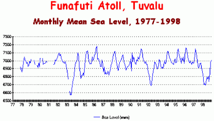
⇧ 2000
↑ Pegelmessungen widerlegen die Panik-Aussagen
-
John L. Daly
2000 en Tuvalu - Pacific Islands

↑ Salomonen-Inseln (Pacific Islands)
- Allgemein
- 2016
- de Rote Karte für Klimaretter: Wissenschaftler wehrt sich gegen alarmistische Berichterstattung zu seiner Meeresspiegelstudie auf den Salomonen Inseln
- de Schon fünf Salomonen-Inseln sind durch den Klimawandel versunken - obwohl der Pegel dort nicht gestiegen ist
⇧ Allgemein
-
Wikipedia
de
Salomonen
en Solomon Islands
fr Salomon (pays)
⇧ 2016
↑ Rote Karte für Klimaretter: Wissenschaftler wehrt sich gegen alarmistische Berichterstattung zu seiner Meeresspiegelstudie auf den Salomonen Inseln
-
Die kalte Sonne (Fritz Vahrenholt & Sebastian Lüning)
2016-05-29 de Rote Karte für Klimaretter: Wissenschaftler wehrt sich gegen alarmistische Berichterstattung zu seiner Meeresspiegelstudie auf den Salomonen Inseln
↑ Schon fünf Salomonen-Inseln sind durch den Klimawandel versunken - obwohl der Pegel dort nicht gestiegen ist
-
EIKE Europäisches Institut für Klima und Energie
2016-05-14 de Schon fünf Salomonen-Inseln sind durch den Klimawandel versunken - obwohl der Pegel dort nicht gestiegen ist
↑ Takuu
- Allgemein
- 2016
- de Bremer Leibniz-Zentrum für Marine Tropenökologie: "Unsere Daten lassen keine Rückschlüsse darauf zu, dass sich der Anstieg des Meeresspiegels bei den Takuu-Inseln in den letzten 70 Jahren negativ bemerkbar gemacht hat"
⇧ Allgemein
-
Wikipedia
de
Takuu
en Takuu Atoll
fr Takuu
⇧ 2016
↑ Bremer Leibniz-Zentrum für Marine Tropenökologie: "Unsere Daten lassen keine Rückschlüsse darauf zu, dass sich der Anstieg des Meeresspiegels bei den Takuu-Inseln in den letzten 70 Jahren negativ bemerkbar gemacht hat"
-
Die kalte Sonne (Fritz Vahrenholt & Sebastian Lüning)
2016-02-02 de Bremer Leibniz-Zentrum für Marine Tropenökologie: "Unsere Daten lassen keine Rückschlüsse darauf zu, dass sich der Anstieg des Meeresspiegels bei den Takuu-Inseln in den letzten 70 Jahren negativ bemerkbar gemacht hat"Prophezeiungen
Riffinseln gehören zu den Landformen, die am stärksten vom Anstieg des Meeresspiegels bedroht sind.
Für das Takuu-Atoll mit seiner mehr als tausend Jahre alten polynesischen Kultur prophezeien Forscher, dass die Inselgruppe schon innerhalb der nächsten Jahrzehnte nicht mehr bewohnbar sein werde.
Die Regierung soll bereits Pläne vorbereitet haben, um die Bevölkerung des Atolls als sogenannte "Klimaflüchtlinge" umzusiedeln.
Die erschreckende Problematik war sogar das Thema einer preisgekrönten Dokumentation mit dem Titel "There Once Was An Island" aus dem Jahr 2010.
Veränderungen der Strände
Zum Bild des untergehenden Takuu-Atolls trugen auch Veränderungen der Strände bei.
Allerdings nahm die Strandfläche wiederum nur bei einigen Inseln ab.
Auf diesen wurden große Mengen an Strandsand von den Bewohnern abgetragen und für Warften verwendet, da es auf Takuu Brauch ist, die Häuser der Dorfältesten erhöht zu bauen.
"Obwohl der Anstieg des Meeresspiegels bereits vor rund 100 Jahren begann und seit den 1990er Jahren noch deutlich schneller verläuft,
hat sich die Vegetationsfläche der Takuu-Inseln zwischen 1943 und 2012 insgesamt sogar um drei Prozent vergrößert".
"Unsere Daten lassen keine Rückschlüsse darauf zu, dass sich der Anstieg des Meeresspiegels bei den Takuu-Inseln in den letzten 70 Jahren negativ bemerkbar gemacht hat",
Korallen
"Die Inseln sind gesäumt von lebenden Korallen, die sich sozusagen in einem Wettlauf mit dem Meeresspiegel befinden.
Korallen können bis zu 20 cm pro Jahr in die Höhe wachsen,
ganze Korallenriffe immerhin noch etwa 8 mm im Jahr,
also durchaus schneller als der derzeitige Meeresspiegelanstieg."
↑ Malediven (Indischen Ozean, westlich von Sri Lanka)
de Allgemein en General fr Générale
de Verzeichnis en Contents fr Sommaire
- 2018
- de Früher war hier der Strand ...
- de
Regierung der Malediven: Wo bleiben unsere Klima-Reparationen?
en Maldives Government: Where's Our Climate Cash? - 2015
- de Ex-Präsident der Malediven zu 13 Jahren Haft verurteilt
- 2010
- en
The Maldives Are Not Sinking
- 2009
- en Open Letter to President Mohamed Nasheed of the Maldives
- en Despite popular opinion and calls to action, the Maldives are not being overrun by sea level rise
- 2003
- en
The Maldives sea level project
Part I: General outlines
Part II: Past-present-future
de Text en Text fr Texte
⇧ 2018
↑ Früher war hier der Strand ...
![]()
![]() Lage der Malediven und Pegel-Messstationen.
Lage der Malediven und Pegel-Messstationen.

-
EIKE Europäisches Institut für Klima und Energie
Helmut Kuntz
2018-05-15 de Früher war hier der Strand ...Das Portal "Klimaretter" ist nun zu "Klimareporter" umfirmiert.
Der Sinn ist nicht verständlich, denn Art und Inhalt sind nach erstem Augenschein unverwechselbar gleich geblieben.
Vielleicht kann die Umbenennung aber auch einfach daran liegen, dass "Klima-Reporting" neuerdings zusätzlich gefördert wird, wie es ein aktuell im neuen Portal gebrachtes Beispiel einer "Klimafolgen-Reportagenreise" zu den Malediven ausweist:
"Die Reportage-Reise wurde durch die Deutsche Gesellschaft für die Vereinten Nationen unterstützt"
↑
Regierung der Malediven: Wo bleiben unsere Klima-Reparationen?
en
Maldives Government: Where's Our Climate Cash?
![]()
![]() Bauboom in der Inselhauptstadt Male.
Bauboom in der Inselhauptstadt Male.
Sieht es so aus, wenn man vermeintlich dem Untergang geweiht ist?

-
EIKE Europäisches Institut für Klima und Energie
Eric Worrall / Chris Frey
2018-04-29 de Regierung der Malediven: Wo bleiben unsere Klima-Reparationen?Der Umweltminister der Malediven Thoriq Ibrahim hat gewarnt, dass das Ziel, die globale Erwärmung auf 1,5°C zu begrenzen, gebrochen wird, falls die Malediven nicht bis zum Jahr 2020 die ihm zustehenden Klima-Reparationen erhält.
-
Watts UP With That? (Antony Watts) / Eric Worrall
2018-04-26 en Maldives Government: Where's Our Climate Cash?Maldives Environment Minister Thoriq Ibrahim has warned that unless the Maldives gets its climate cash before 2020, the 1.5° C global warming limit will be breached.
⇧ 2015
↑ Ex-Präsident der Malediven zu 13 Jahren Haft verurteilt
-
Basler Zeitung
2015-03-14 de Ex-Präsident der Malediven zu 13 Jahren Haft verurteiltMohamed Nasheed war der erste demokratisch gewählte Präsident des Inselstaats, wurde aber gestürzt, nachdem er einen Richter hatte verhaften lassen.
Nun ist er selber ins Gefängnis gebracht worden.
⇧ 2010
↑ en The Maldives Are Not Sinking
-
Prof. em. Nils-Axel Mörner
2010-06-04 en
The Maldives Are Not Sinking
An excerpt of the documentary "Global Warming Doomsday Called Off!"
In this clip professor Nils Axel Morner, from Stockholm University travels to the Maldives and finds out that the ocean levels have dropped in recent years.
⇧ 2009
↑ en Open Letter to President Mohamed Nasheed of the Maldives
-
ResearchGate / Nils-Axel Mörner
2009-10-20 en Open Letter to President Mohamed Nasheed of the MaldivesMr. President,
You have recently held an undersea Cabinet meeting to raise awareness of the idea that global sea level is rising and hence threatens to drown the Maldives.
This proposition is not founded in observational facts and true scientific judgements, Accordingly it is incorrect.
Therefore, I am most surprised at your action and must protest to its intended message.
In 2001, when our research group found overwhelming evidence that sea level was by nomeans in a rising mode in the Maldives,
but had remained quite stable for the last 30 years,
I thought it would not be respectful to the fine people of the Maldives if I were to return home and present our results in international fora.
Therefore, I announced this happy news duringan interview for your local TV station.
However, your predecessor as president censored and stopped the broadcast.
When you became president, I was hoping both for democracy and for dialogue.
However, I have written to you twice without reply.
Your people ought not to have to suffer a constantclaim that there is no future for them on their own islands.
This terrible message is deeply inappropriate, since it is founded not upon reality but upon an imported concept, which lacksscientific justification and is thus untenable.
There is simply no rational basis for it.
Let me summarize a few facts
(see Fig. 1, and evidence presented in Mörner, 2007):
- In the last 2000 years, sea level has oscillated with 5 peaks reaching 0.6 to 1.2 m abovethe present sea level.
- From 1790 to 1970 sea level was about 20 cm higher than today.
- In the 1970s, sea level fell by about 20 cm to its present level.
- Sea level has remained stable for the last 30 years, implying that there are no traces ofany alarming on-going sea level rise.
- Therefore, we are able to free the Maldives (and the rest of low-lying coasts and islandaround the globe) from the condemnation of becoming flooded in the near futur
...

-
International Climate Science Coalition (ICSC)
2009-10-20 en Open letter to president of Maldives - No sea lever "threat"

↑ en Despite popular opinion and calls to action, the Maldives are not being overrun by sea level rise
-
Whats Up With That? (Antony Watts)
2009-03-19 en Despite popular opinion and calls to action, the Maldives are not being overrun by sea level rise
⇧ 2003
↑
en
The Maldives sea level project:
Part I: General outlines
Part II: Past-present-future
-
Nils-Axel Mörner
The Maldives sea level project
2003-07-30 en Part I: General outlines
2003-07-30 en Part II: Past-present-future
↑ Totope (Ghana)
- Allgemein
- 2017
- de Leiterin des ARD-Afrika-Studios Nairobi liegt in Ghana voll daneben: Peinliche Verwechslung von Küstenströmungen mit Klimawandel
- de Fake-News: Diesmal die Tagesschau am 18.5.2017, Totope - ein Dorf versinkt
⇧ Allgemein
⇧ 2017
↑ Leiterin des ARD-Afrika-Studios Nairobi liegt in Ghana voll daneben: Peinliche Verwechslung von Küstenströmungen mit Klimawandel
-
Die kalte Sonne (Fritz Vahrenholt & Sebastian Lüning)
2017-06-14 de Leiterin des ARD-Afrika-Studios Nairobi liegt in Ghana voll daneben: Peinliche Verwechslung von Küstenströmungen mit KlimawandelARD-Korrespondentin Sabine Bohland aus dem ARD-Studio Nairobi leistete sich am 18. Mai 2017 in der Tagesschau schlimmen Klimaalarm:
Klimawandel in Ghana: Totope - ein Dorf versinkt
Das Grundwasser versalzen, die Häuser vom Meer bedroht - wer den Klimawandel hautnah beobachten möchte, kann das in Totope tun.
Das Dorf in Ghana leidet unter dem Anstieg des Meeresspiegels - genau wie Hunderte weitere an Afrikas Westküste. [...]
Totope ist nicht das einzige Dorf an Ghanas Küste, das durch den steigenden Meeresspiegel und die Küstenerosion zerstört wird.
Hier mag es besonders schlimm sein, weil nicht mal ein Damm aus Felsbrocken errichtet wurde, um die Wellen abzuhalten, wie in einigen anderen Orten.
Aber das wäre auch nur eine Maßnahme auf Zeit.
Von Mauretanien bis Kamerun gibt es ähnlich betroffene Dörfer, überall leiden die Menschen unter dem Klimawandel.
Das klingt alles dramatisch.
Schuld hat laut Aussage von Frau Bohland der menschengemachte Klimawandel, also wir alle.
Aber wie robust ist die Ursachenforschung der Korrespondentin eigentlich wirklich?
Eine Naturwissenschaftlerin scheint sie nicht zu sein.
Über das Studium von Sabine Bohland schweigt sich das Internet aus.
Vermutlich hat sie ein geisteswissenschaftliches Studium absolviert, wie so viele andere Medienschaffende.
Dabei ist klar, dass im Fall der Ghana-Story vor allem geologisches Wissen und Kenntnisse der Küstendynamik notwendig wären.
Werfen wir zunächst einen Blick auf Totope auf einer Google Karte.
Der Küstenort liegt in Südost-Ghana:
Erkennen Sie auch die seltsam langgezogenen Küstenstreifen?
In der Ostsee heißt so etwas Nehrung, auf englisch sand barrier.
Sie entstehen durch starke küstenparallele Strömungen.
Ein wichtiges Merkmal dieses Küstentyps ist, dass sich diese Sandzungen ständig verlagern, nie längerfristig stabil bleiben.
Das hätte Frau Bohland wissen können, ja müssen, wenn sie im Geographieunterricht damals besser aufgepasst hätte.
Die im Beitrag dem Klimawandel zugeschriebenen Auswirkungen sind also vor allem küstendynamische Prozesse wie sie auf diesem Planeten bei diesem Küstentyp tausendfach auftreten.
Es klingt hart, ist aber leider wahr: Sabine Bohland verbreitet hier Fake News.
Hätte sie doch jemanden gefragt, der sich damit auskennt. Im gesamten Beitrag der Tagesschau taucht bemerkenswerterweise kein einziger Wissenschaftler auf.
↑ Fake-News: Diesmal die Tagesschau am 18.5.2017, Totope - ein Dorf versinkt
-
EIKE Europäisches Institut für Klima und Energie
Prof. Dr. Horst-Joachim Lüdecke und Klaus-Eckart Puls
2017-06-03 de Fake-News: Diesmal die Tagesschau am 18.5.2017, Totope - ein Dorf versinktDie Fernsehjournalistin Sabine Bohland vom ARD Studio in Nairobi läutet die Alarmglocken:
"Der menschgemachte Klimawandel lässt das Meer ansteigen, ganze Küsten Afrikas saufen ab".
Ist es tatsächlich so schlimm?
Glücklicherweise nicht, denn es handelt sich um einen lupenreinen Fake. Schauen wir uns hierzu die Realität näher an!
Das Thema Meeresspiegelanstieg ist komplex und bedarf einiger Grundinformationen.
Ohne diese kann nur sachlicher Unsinn wie in der hier kritisierten Tagesschau-Sendung herauskommen.
Für diese Grundinformation möge sich der Leser bitte zuerst unser Informations-Video anschauen.
Das Video basiert auf der wissenschaftlichen Fachliteratur.
Wir empfehlen, es vollständig anzusehen.
Wer es eilig hat, kann natürlich gleich zu Minute 16:33 gehen, dort beginnt das Thema Meeresspiegel.
Aber bitte zumindest erst diesen Meerespiegelabschnitt vor dem Weiterlesen ansehen!
Fachinformation über Klima und Energie
-
EIKE Europäisches Institut für Klima und Energie
Prof. Dr. Horst-Joachim Lüdecke, EIKE Pressesprecher
2017-04-25 de
Video Folge 1: Ist der Klimawandel vom Menschen verursacht?
Das Klimagespräch mit Anton und Beate
(Extremwetter, Weltklimarat IPCC, Gletscher, Meeresspiegel)
-
EIKE Europäisches Institut für Klima und Energie
Prof. Dr. Horst-Joachim Lüdecke, EIKE Pressesprecher
2017-04-25 de Eine erste komplette Fachinformation über Klima und Energie in YoutubeEinleitung
Die Bevölkerung wird über Klima, Energiewende und Kernkraft noch nicht einmal in Ansätzen korrekt informiert.
Grob falsch oder überhaupt keine Information sind in den deutschen Medien die Regel.
Aus diesem Grunde erarbeiten wir aktuell eine Reihe von insgesamt 6 Fachinformations-Videos, jedes mit einer Dauer von 15-20 Minuten.
Totope: Fakten vs. Fake
Über Totope liegen keine Messdaten von Meeresspiegelhöhen vor.
Die nächsten Stationen im so gut wie datenfreien Afrika sind zum Glück relativ nahe.
Es sind Takoradi, etwa 300 km in nördlicher Richtung von Totope entfernt und Dakar etwa 2200 km Luftlinie weit weg.
Beide Stationen liegen wie Totope an der afrikanischen Atlantik-Küste.
Wir gehen daher von sehr ähnlichen Meereshöhenveränderungen wie bei Totope aus.
Bei Takoradi erkennen wir
Von 1930 bis 1972 (42 Jahre) einen Anstieg von etwa 220 mm, macht etwa 5 mm / Jahr ansteigenden Spiegel.
Von 1972 bis 1985 (13 Jahre) ein Abfallen von etwa 500 mm, macht etwa 38 mm / Jahr sinkenden Spiegel
Von 1985 bis heute (32 Jahre) einen Anstieg von etwa 500 mm, macht etwa 16 mm / Jahr ansteigenden Spiegel
Takoradi
Mit dem Auge geschätzt hat sich der Meeresspiegel von Takoradi in den vergangenen 90 Jahren grob um 200 mm erhöht.
Das sind etwa 0,5 mm im Jahr,
Dakar
Bei Dakar erkennen wir dagegen - so gut wie nichts!
Abgesehen von starken Monatsfluktuationen ist weder Anstieg noch Absinken des Meeresspieges über 25 Jahre erkennbar.
Ein "Klimawandel" ist in den Messwerten von Takoradi oder Dakar jedenfalls nicht zu sehen.
Mit dem Verlauf von "globalen" Lufttemperaturen oder gar des atmosphärischen CO2 in dem Zeitraum ab etwa 1930 haben demnach die Meeresspiegelveränderungen von Totope nichts zu tun.
Die "Tagesschau-Überschwemmungs-Katastrophe" ist ein Fake, in den Mesungen ist sie nicht zu finden.
-
↑ Talpatti
⇧ Allgemein
-
Wikipedia
de
South Talpatti
en New Moor
fr Île Sud Talpatti
⇧ 2010
↑ Die Insel Talpatti im Golf von Bengalen - Die Insel des Weltuntergangs!
-
Wikipedia
de
South Talpatti
en New Moore, or South Talpatti
fr Île Sud Talpatti
![]()
![]()
Quelle / Source:
-
EIKE Europäisches Institut für Klima und Energie
Klaus-Eckart Puls
2010-03-27 de Die Insel des Weltuntergangs!Eine DPA-Meldung geistert durch die Medien:
Im Golf von Bengalen ist eine Insel namens Talpatti verschwunden.
Glaubt man den Medien, dann ist es ein erstes Signal, daß der nun dramatisch steigende Meersspiegel hiermit den Weltuntergang eingeläutet hat.
Schaut man allerdings etwas genauer hin
Zunächst einmal ist festzustellen, daß die genannte Insel im äußeren Mündungs- und Deltabereich der riesigen Ströme Ganges und Brahmaputra liegt.
Diese Flüsse transportieren jährlich Millionen Tonnen Sand und Schlamm in den Golf von Bengalen.
Die Folgen sind die gleichen wie zum Beispiel an der deutschen Nordseeküste:
Es entstehen und vergehen Sandbänke, Dünen und Inseln -
hier durch die Gezeiten-Ströme und die Nordsee-Orkane,
dort durch die großen Flüsse und die Zyklone.
Die Insel Talpatti (9 km2) hatte etwa die Größe der kleinen Frieseninsel Baltrum (7 km2).
Darüber hinaus ist festzustellen,
daß nach den Messungen der Satelliten-Radarsysteme TOPEX/POSEIDON die Meeresspiegel-Änderungen im Golf von Bengalen einerseits geringfügig und andererseits keineswegs einheitlich waren und sind, wie die Abbildung zeigt.
Schließlich ist darauf hinzuweisen,
daß sich die Regierung von Bangladesch energisch gegen die ständigen Behauptungen von Vertretern des IPCC zur Wehr setzen.
Seit Jahren hört man vom IPCC und seinen Instituten Horror-Prognosen zu überfluteten Küsten in aller Welt, insbesondere auch zu Bangladesch:
"...IPCC hat den Untergang von Bangladesch vorhergesagt,
...den Verlust von 17% seiner Landmasse bis 2050 aufgrund des Meeresspiegel-Anstieges infolge der globalen Erwärmung",und weiter a.a.O.: "Das Nobel-Preis-Träger-Gremium sagt, daß 20 Millionen Menschen in Bangladesch bis 2050 zu Umweltflüchtlingen werden, und daß das Land 30% seiner Nahrungsmittel-Produktion verlieren wird",
und weiter a.a.O.: "Der Direktor des NASA-Goddard-Instituts James Hansen zeichnet ein noch grauenhafteres Bild mit der Vorhersage, das ganze Land könnte bis zum Ende des Jahrhunderts unter Waser stehen".
Da hielt bisher auch das Potsdamer Institut PIK gut mit: "Schellnhuber etwa zeigt sich überrascht von der Dynamik des Klimawandels und sieht "im schlimmsten Fall" einen Meeresanstieg von zwei Metern bis 2100 und eine "biblische Völkerwanderung" kommen.
Denn betroffen wären in den Küstenregionen 500 Millionen bis eine Milliarde Menschen.
Natürlich trifft es besonders die Ärmsten wie in Bangladesch".
Die Reihe derartiger Zitate ließe sich hier beliebig fortsetzen ...
Die Realität sieht offensichtlich und glücklicherweise(!!) ganz anders aus
"Neue Daten zeigen, daß Bangladesch's Landmasse zunimmt,
im Gegensatz zu den Vorhersagen, daß diese südasiatische Nation bis Ende des Jahrhunderts unter den Wellen verschwindet, wie "Experten" behaupten.
Wissenschaftler des Instituts für Umwelt und Geographie Dhaka haben Satelliten-Daten der letzten 32 Jahre ausgewertet und sagen, Bangladesch's Landmasse hat in dieser Zeit jährlich um 20 km2 zugenommen."
Seit 1973 summierte sich das erheblich und beachtlich:
"Satellitenbilder im Vergleich mit Landkarten zeigen seit 1973, daß rund 1000 km2 Land aus dem Meer entstanden sind".
Zwei Gründe zeichnen dafür verantwortlich:
- Die beiden großen Ströme Brahmaputra und Ganges transportieren ständig große Mengen Schwebestoffe stromabwärts, die sich im Delta ablagern,
-
Die vom IPCC seit 15 Jahren prognostizierte Beschleunigung des Meeresspiegel-Anstiegs findet nicht statt, sondern der Anstieg verlangsamt sich weltweit.
↑ Manila
-
Wikipedia
de
Philippinen
en Philippines
fr Philippines
- 2017
- de
Manila versinkt durch Wasserentnahme im austrocknenden
Untergrund.
Der (reiche) Westen mit seinem CO2 soll daran schuld sein - und zahlen
⇧ 2017
↑ Manila versinkt durch Wasserentnahme im austrocknenden Untergrund
-
EIKE Europäisches Institut für Klima und Energie
Helmut Kuntz
2017-08-13 de Manila versinkt durch Wasserentnahme im austrocknenden UntergrundIn der philippinischen Hauptstadt Manila ist der Meeresspiegel, relativ zur Küste, in den vergangenen Jahrzehnten um 80 Zentimeter gestiegen
Der (reiche) Westen mit seinem CO2 soll daran schuld sein - und zahlen.
Panik-Webseiten
klimaretter.info
de Philippinen: Alleingelassen im Klimawandel... Die Philippinen leiden besonders stark unter dem steigenden Meeresspiegel.
Auf den Kosten bleiben sie sitzen, denn von den Industrienationen, den Verursachern des Klimawandels, kommt keine Hilfe.
Und die internationale Gemeinschaft tut wenig, um den ersten Opfern des Klimawandels zu helfen.
Wir haben von den reichen Ländern kein Geld gesehen, um uns zu helfen, uns anzupassen.
So können wir nicht weitermachen.
Das ist kein Leben, wenn wir am Ende immer vor Stürmen davonlaufen müssen.
Organisationen und Medien
Asian Development Bank
en Asia's Booming Cities Most At Risk from Climate Change
Laut einer Studie der Asiatischen Entwicklungsbank von 2012 gehören die Philippinen zu den fünf am meisten vom Klimawandel bedrohten Ländern.
Bangkok, Dhaka, Guangzhou, Ho Chi Minh City, Kolkata, Manila, Mumbai, Shanghai, and Yangon have one thing in common.
These low-lying or coastal cities are all highly vulnerable to rising sea levels, floods, and other impacts of climate change
Tatsachen
In der philippinischen Hauptstadt Manila ist der Meeresspiegel, relativ zur Küste, in den letzten 50 Jahren um ca. 80 cm, also ungefähr mit 16 mm Pegelanstieg pro Jahr gestiegen.
Dieser Pegelanstieg führt vor Ort zu massivsten Problemen und bei einer Multi-Millionenstadt auch zu extremen Kosten.
Fragen
Ist solch ein Pegelanstieg durch einen Klimawandel überhaupt möglich?
Wer sich mit Tidenpegel beschäftigt, weiss, dass dieser global mit ungefähr 1,5 mm / pa natürlich steigt.
Es erscheint alleine dadurch irgendwie unwahrscheinlich, dass ein kleiner Fleck im Pazifik über so lange Zeit so stark davon abweichen sollte.
Liest man zum Pegelbild von Manila den Bildtext von correctiv.org, ahnt man auch schon etwas: Das Problem könnten Landsenkungen sein
Ursache: Landsenkungen
Liest man zum Pegelbild von Manila den Bildtext von correctiv.org, ahnt man auch schon etwas: Das Problem könnten Landsenkungen sein
Manila pumpt sich selbst sprichwörtlich in den Sumpf
Eine Stadt mit (inclusive der Randbezirke) ca. 13 Millionen Einwohnern benötigt viel Wasser.
Und in Manila wird dieses aus dem die Stadt tragenden Boden gepumpt.
Als direkte Folge versinkt diese Metropole darin mit rasender Geschwindigkeit.
Publiziert wird es jedoch (immer noch) als vom Klimawandel verursachter Pegelanstieg.
Diese Kenntnis ist nicht neu, sondern wurde bereits im Jahr 2003 in einer Studie beschrieben
Vertuschungen und Irreführungen
Auf Klimaretter veröffentlichten Artikel ist kein Hinweis zur Landabsenkung enthalten.
Zwar kommt in der Überschrift das Wort "relativ zur Küste" vor.
Dahinter wird ein Laie aber wohl kaum vermuten, dass genau dieses Wort den gesamten Artikel negiert.
Der Link zur Weltbankstudie ist ebenfalls so "getextet", dass wohl niemand darauf kommen würde, dass gerade in dieser Studie eine Information zur Landabsenkung hinterlegt ist.
↑ Panama Inseln
- Allgemein
- 2017
- de Unter falscher Flagge: Erst zerhacken Panama-Insulaner ihren Korallenschutzgürtel, jetzt wollen sie als Klimaflüchtlinge gerettet werden
⇧ 2017
↑ Unter falscher Flagge: Erst zerhacken Panama-Insulaner ihren Korallenschutzgürtel, jetzt wollen sie als Klimaflüchtlinge gerettet werden
-
Die kalte Sonne (Fritz Vahrenholt & Sebastian Lüning)
2017-09-27 de Unter falscher Flagge: Erst zerhacken Panama-Insulaner ihren Korallenschutzgürtel, jetzt wollen sie als Klimaflüchtlinge gerettet werdenWie so oft beim Klimawandel-Journalismus liegt der Ursprung der Nachricht bei dpa.
Bereits die Erwähnung von "flachen Sandinseln" im Text lässt aufhorchen.
Ob es sich wieder einmal um strömungsbeanspruchte Inseln handelt, die sich sowieso ständig in Bewegung befinden?
Alle die schon einmal an der deutschen Nordsee- und Ostseeküste waren, kennen die typischen Nehrungshaken und langgezogenen Sandinseln, die sich fortwährend verlagern, z.B. Norderney.
Ein Blick auf das von web.de mitgelieferte Luftfoto von Kuna Yala genügt, um dies zu bestätigen.
Klimawandel: Inseln vor Panama versinken im Meer
Wegen des drohenden Untergangs vieler Inseln vor Panama haben die dort lebenden Ureinwohner die dortige Regierung um Hilfe gebeten.
In einem Artikel in Eye on Latin America wird dies ebenfalls hervorgehoben:
Panama: Climate change could force out entire island indigenous community
Rising sea levels due to climate change are forcing one of Panama's most well-known indigenous groups to draw up plans to relocate from their autonomous island territories to the mainland.
⇧ Webseiten
⇧ 2018
↑ Flashcrash Klimaalarm. Wer Klimaalarm posaunt, bekommt immer recht (Teil 1)
Teil 1
![]()
![]() Pegel-Zukunfts-Projektionen verschiedenster Quellen.
Pegel-Zukunfts-Projektionen verschiedenster Quellen.
-
EIKE Europäisches Institut für Klima und Energie
Helmut Kuntz
2018-03-06 de Flashcrash Klimaalarm. Wer Klimaalarm posaunt, bekommt immer recht (Teil 1)Eine Meldung raste vor kurzem durch Deutschland: Der Meeresspiegel steigt dramatischer an, als bisher angenommen, der Anstieg wird wahrscheinlich noch höher ausfallen als von den Forschern prognostiziert.
Praktisch alle Medien und die "Öffentlich-Rechtlichen" beeilten sich, den deutschen Bürgern diese neue Schreckensmeldung zum Klimawandel zu überbringen.
de Panik-Küche en Panic laboratory fr Marmite alarmiste
-
Spiegel Online
2018-02-12 de Satellitenmessungen: Meeresspiegel steigt immer schnellerDie Erhöhung des Meeresspiegels beschleunigt sich, berichten Klimaforscher unter Berufung auf Satellitendaten.
Diese zeigen, dass die Pegel in den vergangenen Jahren schneller angestiegen sind als bisher angenommen.
Teil 2
-
EIKE Europäisches Institut für Klima und Energie
Helmut Kuntz
2018-03-07 de Flashcrash Klimaalarm. Wer Klimaalarm posaunt, bekommt immer recht (Teil 2 und Abschluss)In diesem Teil wird dargestllt, wie sich sogenannte "Fachpersonen" dazu äußerten.
Wiederholung
Das nachträgliche "Richtigstellen" aufgrund "ganz neuer" Erkenntnisse bisher doch nicht richtiger Daten ist auch beim Satellitenpegel gängige Praxis.
Da niemand wirklich weiß, wie die "wahren" Daten aussehen, werden Korrekturen über Korrekturen gesetzt und zur gleichen Zeit mit den gleichen Daten auch schon mal gegenteilige Ergebnisse ermittelt.
Es handelt sich dabei um den typischen Fall von "Datenfolter".
Bei diesem Verfahren "gestehen" Messdaten nach einer Weile alles, was man von ihnen verlangt.
Willige Computer nehmen diese "erfolterten Datenergebnisse" auf und ermitteln daraus die Flugrouten zum "Pegelgipfel-Blocksberg".
Der BR nutze die Studie für eine Klimapropaganda-Frontaldarstellung
de Panik-Küche en Panic laboratory fr Marmite alarmiste
-
Bayerischer Rundfunk
2018-02-13 de
Steigende Pegel: Wenn der Meeresspiegel steigt und Inseln versinken
Weil der Klimawandel das Eis der Polarregionen schmelzen lässt, steigt der Meeresspiegel.
Und das immer schneller.
Die Folgen sind verheerend.Extremmodelle berechnen Anstieg um bis zu 1,70 Meter.
Verschiedene Studien der vergangenen Jahre prognostizieren einen Meeresspiegelanstieg zwischen 30 Zentimetern und mehr als anderthalb Metern bis zum Ende dieses Jahrhunderts.
Der Weltklimarat IPCC warnt davor, dass bis 2100 die Meerespegel um bis zu 82 Zentimeter steigen könnten.
Dass beim deutschen Küstenschutz zum Teil mit einem Anstieg um bis zu 1,70 Meter gerechnet werde, erklärt Ingo Sasgen mit Extremwerten, die dabei angenommen worden seien.
Zur Klärung gibt es Fachpersonen
Sollte man meinen.
Diese dürfte es auch geben, doch werden solche von unseren Medien selten, bis nicht befragt.
Welches "Blatt", oder "Öffentlich-Rechtlicher" möchte sich schon eine tolle Story wie den doppelten Meeresspiegelanstieg, durch eine banale Antwort wie
"die Auswertung ist der übliche, statistische Müll, der zur Fütterung der Mediengier produziert wird ... " kaputtmachen lassen.
Das ist auch nicht erforderlich.
Experten, welche des zustimmenden Lobes voll sind, sofern die Richtung stimmt, finden sich genug.
Man beachte die Antworten:
Es wurde von den "Experten" nicht nachgefragt, warum die schon lange bekannten, gleichen Daten schon wieder zu "neuen" Erkenntnissen führen sollen, welche zudem bisherigen, aktuellen widersprechen.Es wurde nicht gefragt, warum die Satellitenpegel plötzlich noch stärker ansteigen (sollen), obwohl sie bereits meilenweit über dem Tidenpegelanstieg liegen.
Es reicht als "Qualitätsbeleg", dass ein (alarmistischer) IPCC-Wert im Maximalszenario "getroffen" wurde.
Achgut hat einen Verdacht
Der Staatsfunk soll vermitteln:
Deutschland muss mal kurz mit seinem Kohleausstieg die Welt retten
-
Achtgut.com Die Achse des Guten / Günter Ederer
2018-02-13 de Höchste Pegelstände in der Volkserziehung"Forscher schlagen Alarm. Der Meeresspiegel steigt schneller als angenommen. Schuld ist die Erderwärmung".
Gleich zweimal kündigte so heute-journal-Moderatorin Petra Gerster einen Beitrag in der ZDF-Nachrichtensendung am 13. 2. 2018 an.
Eigentlich ist diese Drohung in der dramatisierenden Klimaberichterstattung in vielen Versionen bekannt.
So und ähnlich werden wir doch schon seit Jahren auf den Weltuntergang vorbereitet.
Der Spiegeltitel mit dem Kölner Dom, dessen Türme gerade noch so aus dem Wasser ragen, ist schon mehr als zwei Jahrzehnte alt.
Also, was war so neu, dass die Nachricht mit einem ausführlichen Bericht am Faschingsdienstag in die wichtigsten Informationssendungen aufgenommen wurde?
Der Beitrag war 2:25 Minuten lang.
Soviel Zeit wird in der 19:00 Uhr Nachrichtensendung nur den wichtigsten Weltereignissen zur Verfügung gestellt.
Weder Petra Gerster noch die Autorin des Beitrags, Christine Elsner, geben auch nur den geringsten Hinweis, wer diese "neuen Erkenntnisse" veröffentlicht hat.
Dubiose unerwähnte Quellen für Angstmacherei
Da das ZDF verschwiegen hat, woher es seine Alarmmeldung hat, kann hier nur darauf verwiesen werde, dass es alten Kamellen aufgesessen ist:
Sie sind nicht neu, sie sind nicht bewiesen und sie gehören zum Klimaalarmmismus, mit dem alle möglichen Eingriffe in unser tägliches Leben gerechtfertigt werden:
Und wer wollte schon am Weltuntergang oder mindestens an der Überflutung weiter Teile unserer Erde verantwortlich sein?
Was dann in dem Beitrag auf Grund der konstruierten Uraltmeldung weiter den Zuhörern erzählt wurde, war mindestens mieser Journalismus, eher aber doch eine Zusammenfassung aus der Propagandaküche der Klimamodellierer.
Fangen wir an mit dem steigenden Meeresspiegel.
Ein einfacher Blick auf die Kurve des Meeresspiegels, gemessen von der NOAA, dem National Enviromental Satellite Data and Information Center, ergibt, dass seit Jahren (Beginn 1993) das Meer im Durchschnitt um 3 mm pro Jahr steigt.
Das kann einmal etwas mehr sein,
oder, wie seit November 2015 bis Januar 2018, überhaupt nicht.
Dieser Anstieg um zirka 30 Zentimeter pro Jahrhundert - das ergeben die Forschungen - ist seit der letzten Eiszeit konstant.
Ihn mit dem Anstieg des CO2-Gehaltes in der Luft zu begründen, ist deshalb reine Spekulation oder Computerrechnerei.
Bleibt noch zu erwähnen, dass die NOAA einer der Hauptlieferanten für den IPCC, den Weltklimarat der UNO ist.
Also ganz bestimmt nicht zu den "Klimaleugnern" gehört.
Der Meeresspiegel hat zu steigen
Fazit:
An der Anmoderation von Petra Gerster ist kein Wort wahr.Entweder wurde hier die eigene Überzeugung zur Nachricht oder aber es wurde unrecherchierte Propaganda übernommen, was auch nicht viel besser wäre.
Daraus ergibt sich die Frage:
Gibt es keinen verantwortlichen Redaktionsleiter für die Nachrichtensendungen, der wenigstens die journalistischen Mindestanforderungen überwacht?Richtig ist,
dass Steven Nerem in der letzten Zeit verstärkt publiziert, offensichtlich um die Ergebnisse des schwedischen Wissenschaftlers Nils Axel Mörner zu entkräften.Mörner und seine 101 Kollegen in der Inqua, der International Union zur Meeresspiegelveränderung und Küstenentwicklung, haben in ihren Berichten festgestellt, dass es keinerlei Anzeichen für eine Beschleunigung des Anstiegs des Meeresspiegels gibt.
Sie hatten sich dabei speziell mit einem "Malediven Meeresspiegel Projekt" befasst und mit den Küstenregionen der Fidji-Inseln.
In beiden Fällen gibt es keine Bedrohung durch einen erkennbaren Anstieg des Meeres.
Bezeichnend, dass Prof. Mörners Studien keinen Widerhall in den deutschen Medien finden.
(Im November war er zu einem Vortrag in Düsseldorf, und kein einziger der sogenannten Umweltredakteure war anwesend.)
Ähnlich werden die in den letzten Wochen veröffentlichten Messergebnisse des National Space Science Technology Centers der University of Alabama in Huntsville übergangen:
Die der Klimatheorie des IPCC, des Weltklimarates, skeptisch gegenüberstehenden Wissenschaftler John Christy und Roy Spencer veröffentlichten Daten, aus denen hervorgeht, dass sie den stärksten Temperaturrückgang in den Tropen, wie seit 6 Jahren nicht mehr, gemessen haben.
Solche Meldungen werden nicht hinterfragt, wie dies journalistisch geboten wäre, sie werden einfach unterschlagen.
Eisschmelze bei 90 Grad Minus
Zurück zur "heute-Sendung".
In dem Beitrag behauptet die Umweltredakteurin des ZDF, dass an beiden Polkappen das Eis schmilzt.
Diese Behauptung fällt unter die Kategorie: dummdreist.
Was für den Nordpol weitgehend stimmt, wo in den letzten Sommern Eis geschmolzen ist, ist für den Südpol barer Unsinn.
Dort wurden in den letzten Jahren neue Minusrekorde gemessen.
Am 10. 12. 2013 zum Beispiel minus 93,2 Grad.Über 80 Grad minus werden immer wieder gemeldet.
Nur von der argentinischen Esperanza Base, die auf einer Halbinsel liegt, die weit nach Norden, fast bis zum Südzipfel Argentiniens reicht, wurde am 23. 3. 2015 einmal 18 Grad plus gemessen.
Die Aussage, an beiden Polkappen schmelze das Eis, ist insofern für die Klimaerwärmer wichtig,
weil damit die Theorie, dass durch die Erdumlaufbahn abwechselnd ein Pol sich erwärmt, während der andere abkühlt, nicht mehr zu halten wäre.
de en fr Polare Klimaschaukel Polar see-saw Balançoire polaire Wer die Berichterstattung über die Antarktis verfolgt, wird daher von ständig sich widersprechenden Nachrichten verwirrt, weil sie ganz offensichtlich mehr die eine oder andere These unterstützen sollen, und nicht einer neutralen Begutachtung unterliegen.
Für die Totalverwirrung einer ZDF-Redakteurin reicht die Überzeugung, dass wir Menschen auch das Eis bei minus 90 Grad noch zum schmelzen bringen.
Natürlich durfte in dem Beitrag nicht der Untergang der Pazifikatolle fehlen.
Christine Elsner nannte als Beispiel die Marshall-Inseln.
Dort war ich und habe eine ZDF-Reportage mit dem Titel: "Das missbrauchte Paradies" gedreht.
Zwei Tage konnten wir nicht auf der Hauptinsel Majuro landen, wegen Überschwemmung der Fahrbahn.
Die liegt nämlich nur zwei Meter über dem Meeresspiegel und ist bei jedem stürmischen Hochwasser nicht zu benutzen - und das war schon immer so.
Diese Inseln werden nicht durch den Anstieg des Meeres dank der Erderwärmung gefährdet, sondern dort kommen mehrere von Menschen gemachte negative Entwicklungen zusammen.
Das beginnt mit der Verwüstung mehrerer Atolle durch die Atombombenversuche.
Sie sind immer noch verstrahlt.
Auf Eniwetok war ich auf dem Plutonium-Dom der noch 30.000 Jahre tödlich strahlt.
Das Kwajalein-Atoll ist gesperrt, weil sich dort eine amerikanische Raketenversuchsstation befindet.
Die Insulaner sind daher auf den verbliebenen Atollen zusammengepfercht.
In Ebeye zum Beispiel gibt es keinen Quadratmeter unbebauten Landes.
Das Wasser wird aus der benachbarten Raketenbasis per Kanister geholt (Stand 1987).
Gleichzeitig aber haben die Marshall-Island Insulaner eine sehr hohe Geburtenrate, die zwar in absoluten Zahlen für die Weltbevölkerung zu vernachlässigen ist, aber die Lebensgrundlage der Korallenatolle überfordern.
In sauberem Wasser würden die Korallen mit einem Wasseranstieg, wie er seit Jahrtausenden stattfand, wachsen.
Das Problem ist die Zerstörung der Umwelt, nicht der Klimawandel.
Aber woher soll das Christine Elsner wissen?
Was passiert, wenn etwas passiert, was aber nicht passiert?
Dann tritt in der Sendung Frau Professor Angelika Humbert vom Helmholtz-Zentrum für Polar- und Meeresforschung auf.
Sie schildert, was passieren würde, wenn der Meeresspiegel so schnell steigen würde, wie die angeblich neuen Erkenntnisse voraussagen.
Dann würde auch die deutsche Nordseeküste unter Wasser stehen, stellt sie fest.
Das hört sich dann sehr wissenschaftlich an.
Aber Frau Professor Humbert hat sich nicht zu den "Erkenntnissen" geäußert.
Sie hat nur bestätigt, dass etwas passiert, wenn etwas passiert.
Sie wurde nicht gefragt, ob der rasante Meeresspiegelanstieg auch passieren wird.
Und dann kam der krönende Höhepunkt der Sendung.
Der Vorgesetzte von Christine Elsner, der "Umweltexperte des ZDF", so der Untertitel, Volker Andres kam zu Wort.
Seine Kernaussage: "Hauptverantwortlich für den Klimawandel ist die Erderwärmung. Die Klimapolitik ist gefordert."
Aus einer konstruierten Hiobsbotschaft einer nicht benannten Quelle in den USA wird eine handfeste innenpolitische Forderung abgeleitet.
Volker Andres: Der Druck auf die Politik nimmt zu.
Die neue Bundesregierung muss handeln und endlich aus der Kohle aussteigen. Das müsse jetzt schnell erfolgen.
Und plötzlich habe ich eine Idee, warum der Beitrag, in dem alle Bilder von den schmelzenden Gletschern, den aufgewühlten Wellen, den bedrohten Südseeinseln, den Baggern voller Kohle, den Landkarten, mit den untergehenden Küstenstreifen, warum das alles in 2:25 Minuten zusammengefasst den Zuschauern übergestülpt wurde:
Es ging, so vermute ich, um einen Beitrag, der die Politik zum Kohleausstieg bewegen soll.
Es ging also darum, das Herzensanliegen der Grünen zu propagieren.
Das hat mit Nachrichten nichts zu tun:
Da geht es um politischen Druck zu erzeugen und um Volksverdummung und - oder - um Volkserziehung.
Deutscher Kohleverzicht soll die Welt retten
Nehmen wir an, der Umweltexperte Volker Andres glaubt wirklich daran, dass die Welt gerettet wird, wenn in Deutschland zehntausende von Arbeitsplätzen wegfallen und die Kohle mit Gaskraftwerken ersetzt wird.
Denn viel mehr Windkraft geht ja kaum noch.
Weiß er, dass Deutschland nur für 2 Prozent des Welt-CO2-Anteils verantwortlich ist, wovon 1,2 Prozent nicht von den Menschen abhängt?
Nehmen wir an, Andres weiß es, aber ist so von der menschengemachten Klimaerwärmung überzeugt, dass er seine Arbeit voll in den Dienst der Menschheitsrettung stellt.
Dann sollte er nicht als Journalist, sondern dann sollte er sich als Hofberichterstatter des Potsdamer Instituts für Klimafolgeforschung oder gleich dem Weltklimarat anbieten.
Angenommen, er kennt den deutschen Anteil nicht, dann sollte er recherchieren lernen, bevor er als leitender Redakteur einer gebührenfinanzierten Anstalt Volksverdummung betreiben darf.
Nach solchen Sendungen ist es kaum verwunderlich, wenn in Meinungsforschungsumfragen zirka 70 Prozent der Bevölkerung die Klimaerwärmung als Gefahr und als eines unserer wichtigsten Probleme bejahen.
Wie sollten sie es auch besser wissen, wenn sie selbst in Nachrichtensendungen indoktriniert werden.
Und weil diese Umfragen wieder unsere Politiker beeinflussen, glauben die auch, sie müssten dringend mit neuen Gesetzen die Welt retten, weil das Stimmen bringt.
Wenn schon Journalisten oder die die sich dafür halten, nicht recherchieren, wie könnten wir dann von den Politikern erwarten, dass sie sich informieren, wie der Weltklimarat arbeitet und warum die Klimapolitiker - vorneweg unsere Kanzlerin - so begeistert das Thema aufnahmen?
Sie können damit ihren Wählern alles Mögliche verordnen, was ihre Macht stärkt.
Irgendwo habe ich gelesen, Politiker und Journalisten leiden, was die Klimarettungspolitik angeht, an ADS, dem Aufmerksamkeits-Defizit-Syndrom.
⇧ 2017
↑ Crashinformation zu den "untergehenden" Pazifikinseln
-
EIKE Europäisches Institut für Klima und Energie
Helmut Kuntz
2017-06-06 de Crashinformation zu den "untergehenden" Pazifikinseln,
Teil 1: Pegelinformationen
-
EIKE Europäisches Institut für Klima und Energie
Helmut Kuntz
2017-06-08 de Crashinformation zu den "untergehenden" Pazifikinseln,
Teil 2: Zusatzinformationen
↑ Land unter im Norden ab 2050 - oder: Pünktlich zur Tagung des UN-Klimasekretariats in Bonn steigt der (simulierte) Meeresspiegel verstärkt
Meerespegelverlauf an der südlichen Nordsee in den letzten 7500 Jahren
![]()
![]() Atlantikum,
Subboreal
Subatlantikum
Atlantikum,
Subboreal
Subatlantikum

Pegel-Zukunfts-Vermutungen zweier deutscher PIK Klimawissenschaftler und vom Rest der Welt
![]()
![]() Anstieg des Meeresspiegels
Anstieg des Meeresspiegels
Beispiel aus dieser "unendlichen", inzwischen makabren Geschichte.
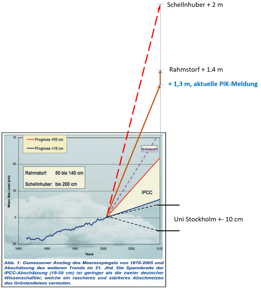
-
EIKE Europäisches Institut für Klima und Energie
2017-05-14 de Land unter im Norden ab 2050 - oder: Pünktlich zur Tagung des UN-Klimasekretariats in Bonn steigt der (simulierte) Meeresspiegel verstärktEinleitung
Belege, dass die Klimawandeldiskussion in Deutschland inzwischen vollkommen in Hysterie und bewusster - auch von der Politik mit gelenkter - Desinformation verkommen ist, werden auf EIKE regelmäßig gebracht.
Anbei wieder ein Beispiel aus dieser "unendlichen", inzwischen makabren - Geschichte.
Wenn Klimaalarm zu melden ist, sind unsere Medien sofort zur Stelle. Zwar verkündet die Lokalzeitung des Autors beispielhaft in großen Anzeigen so etwas wie "jedes Wort in der Zeitung ist wahr", doch wenn dafür extra geworben werden muss, ahnt man, dass darin wohl ein Mangel besteht.
Man muss wissen:
Derzeit findet die jährliche Frühjahrstagung der Vereinten Nationen, eigentlich einem Ableger, dem Klimasekretariat, in Bonn statt.Eine mit ca. 2.800 Delegierten und zehn Tagen Dauer nicht gerade kleine Veranstaltung die zeigt, was für eine umfangreiche, schwierige, langwierige und teure Arbeit es wird, wenn man das Klima weltweit verwalten muss und wie aufwendig bereits die noch recht moderat gehaltenen Vorarbeiten dazu ausfallen.
↑ Südseeträumereien: Märchenstunde mit Onkel Schellnhuber
-
Die kalte Sonne (Fritz Vahrenholt & Sebastian Lüning)
2014-05-23 de Südseeträumereien: Märchenstunde mit Onkel Schellnhuber
↑ Recent Sea-Level Change at Major Cities
-
Watts Up With That? (Antony Watts)
Rich Taylor
2017-03-29en Recent Sea-Level Change at Major Cities
⇧ 2016
↑ Landgewinn trotz Meeresspiegelanstieg
-
Die kalte Sonne (Fritz Vahrenholt & Sebastian Lüning)
2016-09-21 de Landgewinn trotz Meeresspiegelanstieg: Küsten haben sich in den vergangenen 30 Jahren um 13.500 Quadratkilometer ins Meer vorgebaut
⇧ 2015
↑ Südseeatolle: Noch keine der betroffenen Inseln ist in nächster Zeit von Überflutung bedroht. Einige vergrößern sich sogar auf Grund natürlicher ökologischer Vorgänge
-
Die kalte Sonne (Fritz Vahrenholt & Sebastian Lüning)
2015-06-23 de Spektrum der Wissenschaft über angeblich vom Untergang bedrohte Südseeatolle: Noch keine der betroffenen Inseln ist in nächster Zeit von Überflutung bedroht. Einige vergrößern sich sogar auf Grund natürlicher ökologischer VorgängeIm Pazifik gibt es unzählige kleine Koralleninseln, die im Laufe der Jahrtausende vom Menschen besiedelt wurden.
In unseren Träumen liegen wir am Südseestrand, mit einem Strohhalm Kokosmilch schlürfend, die Fußspitzen im warmen Pazifik eingetaucht.
Die Wirklichkeit sieht leider anders aus.
Die meisten Inseln leiden unter einer extremen wirtschaftlichen Unterentwicklung, die Arbeitslosigkeit ist hoch, ebenson wie die Armut.
Da hilft dann auch die leckere Kokosmilch nicht mehr.
Viele Südsee-Insulaner würden gerne nach Australien oder Neuseeland auswandern, scheitern aber an den strengen Immigrationskriterien.
Da kam die klimaalarmistische Bewegung gerade recht:
Man verkündete, die Inseln würden absaufen, und Schuld habe der reiche Westen mit seinem hinterhältigen CO2. Gebt uns Geld und Einwanderungspapiere, schnell!Vielen leuchtete diese Logik ein, insbesondere denjenigen, die sich in den Naturwissenschaften nicht allzu gut auskannten. Geologen, Geographen und andere mitdenkende Menschen hingegen staunten nicht schlecht: Wie haben die Koralleninseln nur den rasanten Meeresspiegelanstieg direkt nach der letzten Eiszeit überstanden, als das Meer bis zu 10-fach schneller anstieg als heute?
Die Antwort ist einfach: Korallen sind Lebewesen, die stets dem Meeresspiegel hinterherwachsen.
Von einem angeblich bevorstehenden Untergang kann daher keine Rede sein.
-
Klima Manifest Heiligenroth 2013-12-09 de
TRAILER und PLAYLIST zu "10 unbequeme Wahrheiten über
Hans J. Schellnhuber" online !!
|
Hans-Joachim Schellnhuber *1950-06-07 |
Professor, Bis September 2018 war er Direktor des 1992 von ihm gegründeten Potsdam-Instituts für Klimafolgenforschung (PIK) ▶Hans-Joachim Schellnhuber: Who is who (Aktivisten der anthropogenen Erwärmung) |
↑ Flussdeltas in Indien und Bangladesch saufen wegen Sedimentverfestigung ab
-
Die kalte Sonne (Fritz Vahrenholt & Sebastian Lüning)
2015-03-23 de Flussdeltas in Indien und Bangladesch saufen ab: N24 lässt Küstenabsenkung als Folge der Sedimentverfestigung als wichtigsten Grund unerwähntAbsinken von Deltas
Deltagebiete sind dafür bekannt, dass sie durch die allmähliche Verfestigung ihrer Sedimente - die sogenannte Kompaktion - absinken.
So berichtete 2013 der Geologe Till Hanebuth über Ergebnisse aus dem Deltabereich Bangladeschs.
Sein Team fand natürliche Absenkungsraten von mehr als 4 Millimeter pro Jahr.
Diese Rate ist deutlich höher als der klimatisch-bedingte Meeresspiegelanstieg.
⇧ 2014
↑ Fachzeitschrift 'Climate of the Past' lehnt Meeresspiegel-Manuskript von Rahmstorf-Gruppe ab: Gutachter finden fundamentale Fehler in der Methodik
-
Die kalte Sonne (Fritz Vahrenholt & Sebastian Lüning)
2014-01-16 de Fachzeitschrift 'Climate of the Past' lehnt Meeresspiegel-Manuskript von Rahmstorf-Gruppe ab: Gutachter finden fundamentale Fehler in der Methodik
↑ Südseeinseln trotzen dem Meeresspiegelanstieg: UNO weist Klimaschadensersatzansprüche der pazifischen Inselstaaten ab
-
Die kalte Sonne (Fritz Vahrenholt & Sebastian Lüning)
2014-01-12 de Südseeinseln trotzen dem Meeresspiegelanstieg: UNO weist Klimaschadensersatzansprüche der pazifischen Inselstaaten ab
↑ Allianz der kleinen Inselstaaten will ans Klimageld ran
-
Die kalte Sonne (Fritz Vahrenholt & Sebastian Lüning)
2014-06-21 de Allianz der kleinen Inselstaaten will ans Klimageld ran
↑ Österreichische Tageszeitung 'Die Presse': Das Klima lässt die Pazifikatolle nicht untergehen!
-
Die kalte Sonne (Fritz Vahrenholt & Sebastian Lüning)
2014-09-13 de Österreichische Tageszeitung 'Die Presse': Das Klima lässt die Pazifikatolle nicht untergehen!
↑ Medshild and Redshild dam against sea level rising in the mediterranean sea
de Panik-Küche en Panic laboratory fr Marmite alarmiste
For the protection of the sea shores of the Mediterranean, Black Sea and Red Sea from the globally rising ocean levels
![]()
![]() MEDSHILD / REDSHILD
MEDSHILD / REDSHILD

![]()
![]() Millennium Energy Project
Millennium Energy Project
DIRE WARNING OF SEA LEVEL RISING

-
MEDSHILD & REDSHILD FOUNDATION GENEVA
en Millennium Energy Project
c/o International Sustainable Energy Organisation
for Renewable Energy and Energy Efficiency
ISEO, PO Box 200, CH-1211 Geneva 20
Tel. +41 22 910 3006, Fax: +41 22 910 3014
e-mail: info@uniseo.org, http://www.uniseo.orgInternational Sustainable Energy Organisation ISEO
en International Sustainable Energy Organisation - ISEO
en CMDC-ISEO Newsletter Summer 2013
-
ICEC - International Clean Energy Consortium
de Wer ist ICEC
en Who is ICEC
de
Im Namen des vom Menschen verursachten Klimawandels
en
In the Name of Human Caused Climate Change
fr
Au nom du changement climatique anthropique
-
EPFL
Ha-Phong Nguyen, Laboratory of Hydraulic Construction, EPFL, 1015 Lausanne, Switzerland2014-08-14 fr Un barrage à Gibraltar pour maîtriser le niveau de la mer
Le projet de Ha-Phong ne verra, sans doute, jamais le jour même s'il s'inscrit dans un rêve commun avec, notamment, un ingénieur suisse nommé Giovanni Lombardi qui avait imaginé un tunnel ferroviaire reliant les deux continents et qui n'a pu aboutir.
Le déplacement des plaques africaines et européennes reste l'un des plus grand obstacle à de telles constructions.
2014-08-14 en A Dam at Gibraltar to Control the Level of the Sea
Ha Phong's project will probably never see the light of day, even if it shares part of a common dream with Swiss engineer Giovanni Lombardi who envisioned a rail tunnel connecting the two continents but was unable to achieve it.
The movement of the African and European tectonic plates remains one of the biggest obstacles to such constructions
-
Académie des Sciences et Lettres de Montpellier
Bernard AUBERT
2015-05-11 fr Le changement climatique, entre conjectures et mutations sociétalesGlaciers, mémoire de notre planète
Page 188: Fig. 3 Remontée du niveau marin depuis 15 000 ansRemontée depuis env. 6000 ans: 1 mm/an
(ce qui corresponds à env. 10 cm jusq'à 2100)Elévation du niveau marin
Page 190:Les données satellitaires collectées jusqu'ici montrent que le niveau marin du globe a gagné 8 cm (en moyenne géographique) entre 1992 à 2015. (ce qui correspods à env. 30 cm jusq'à 2100)
Les équipes internationales du CNES et de la NASA, anticipent pour 2100 une hausse probable de 90 cm.
(c'est alors env. trois fois plus ce qui a été mesuré les 23 dernières années)
Le cas particulier de la Méditerranée
L'ISEO (international sustainable energy organisation), institution basée à Genève, s'efforce de faire émerger un vaste projet de parc à énergie renouvelable géo-hydrolienne.
Ce projet pourrait devenir le moteur d'une politique de co-développement Nord-Sud et serait un exemple pour le reste de la Méditerranée.
En effet la course à l'énergie dans les pays de la rive sud est source d'âpres conflits qui perturbent profondément la vie des sociétés, et constitue l'enjeu majeur des années à venir.
Les pays méditerranéens vont voir leur demande d'énergie primaire passer de 12 700 TWh à 17 500 TWh en 2025, cette augmentation provenant majoritairement de la croissance démographique des pays du sud.
Il est donc essentiel de diminuer la dépendance aux énergies fossiles (pétrole, gaz, charbon)....
Mais il y a d'autres raisons pour s'intéresser au cas de Gibraltar.
Avec l'augmentation de l'évaporation, la puissance des courants de transit s'intensifie, ce qui augmente les risques pour la navigation.
Ce carrefour maritime est extrêmement sensible à la moindre différence de température, de surcote et de houle....
Le remède préconisé serait la construction d'un barrage à Gibraltar comportant un seuil déversoir pour faire entrer les eaux atlantiques de surface côté Nord et un pertuis Sud de sortie des eaux froides et salées....
Le projet de barrage avancé par l'ISEO serait quant à lui un ouvrage fermé, équipé de passes à poissons et d'un canal de navigation dont les écluses hébergeraient des turbines hydroliennes et marémotrices. Il ferait office de rail de sécurité.
-
Executive Intelligence Review
2012-06-08 en After the Euro! An Economic Miracle for South Europe and the Mediterranean!Spain: The World Land-Bridge's Bridge to African Development
Strait of Gibraltar Tunnel: A 40 km tunnel built under the Strait of Gibraltar, from Spain to Morocco, will allow European rail corridors to be connected to future North African rail systems.
This will be a project on the scale, and of the significance, of the Bering Strait tunnel and the Darién Gap project, because like them, it will link an entire continent into the World Land-Bridge.
The Lombardi plan considered the option of a bridge at the narrowest point between the two continents (14 km), but since the seabed there is a very deep 900 meters, it was discarded as impracticable.
The selected route instead runs at a more western point, from Tarifa, Spain, to Tangiers, Morocco, a route where the sea floor is "only" 300 meters deep - which would make this the deepest undersea tunnel in the world.
The length of the tunnel would be about 40 km (see Map 5).
It would consist of two tubes for train lines for both passengers and freight, with an emergency or service tunnel running between them.
Lombardi estimated that it would take about 15 years to build, given the engineering problems to be solved -
including the fact that it would run through a highly active seismic area (the Azores-Gibraltar Transform Fault),
and difficulties in the stratification of the seabed there, described as a virtual "cocktail of sand, stone, and mud that make for a digger's nightmare."
In fact, engineers have had to invent new boring methods just to drill exploratory holes, given the rock formations and the fierce underwater currents.
de Fakten en Facts fr Faits
Meeres-Anstieg für die südliche Nordsee
![]()
![]() Meeres-Anstieg an der Deutschen Nordsee-Küste seit 10.000 Jahren
Meeres-Anstieg an der Deutschen Nordsee-Küste seit 10.000 Jahren

![]()
![]() Meeres-Anstieg für die südliche Nordsee der letzten 3.000 Jahre
Meeres-Anstieg für die südliche Nordsee der letzten 3.000 Jahre

Quelle / Source:
-
EIKE Europäisches Institut für Klima und Energie
Klaus-Eckart Puls (Diplom Meteorologe)
2015-08-28 de Globale Überschwemmung vor Paris ? ... oder eben 200 Jahre später ? ...oder eben NIE ?Der Meeres-Anstieg verläuft seit wenigstens 100 Jahren linear, es gibt keine Beschleunigung des Anstieges.
Ein Signal durch anthropogenes CO2 (AGW) ist nirgends erkennbar.
Das alles steht in krassem Widerspruch zu den Verlautbarungen und insbesondere zu den alarmistischen Prognosen des Klimarates IPCC und einiger Klima-Institute.
Aus den Abbildungen 1 und 2 ergibt sich: Der Meeres-Spiegel ist in den letzten 10.000 Jahren um mehr als 50 Meter gestiegen.
Der Anstieg hat sich immer mehr verlangsamt, wenn man den übergreifenden Trend auch über die Trans- und Regressionen der letzten 3.000 Jahre betrachtet.
In den "jüngsten" 400 Jahren (1600-2000) hat es (ohne GIA-Korrektur) einen Anstieg von 1,35 m gegeben,
in den vergangenen 100 Jahren nur einen solchen von 25 cm,
folglich eine weitere Verlangsamung.
Verlangsamung des Meeres-Anstieges
![]()
![]() Verlangsamung des Meeres-Anstieges am Pegel Cuxhaven (1845-2015)
Verlangsamung des Meeres-Anstieges am Pegel Cuxhaven (1845-2015)

Quelle / Source:
-
EIKE Europäisches Institut für Klima und Energie
Klaus-Eckart Puls (Diplom Meteorologe)
2016-09-22 de Altweibersommer 2016: Alarmsignal für die CO2-Klimakatatstrophe ?Die ständigen Alarm-Meldungen zu angeblich dramatischen Meeres-Spiegel-Anstiegen in Gegenwart und Zukunft können durch Messungen nicht bestätigt werden, sondern werden durch die Meß-Daten sogar widerlegt.
Weltweit zeigen weder die Pegel-Daten (200 Jahre) noch die Satelliten-Daten (20 Jahre) eine Beschleunigung des Meeres-Anstieges.
Dazu in krassem Widerspruch stehen alle bisherigen und derzeitigen Aussagen vom Klimarat IPCC, von einigen Klima-Instituten sowie die der Klima-Modelle.
Darüber hinaus gibt es Anhalts-Punkte dafür daß die Satelliten-Daten zu höheren Beträgen hin erheblich "über-korrigiert" wurden.
Ergebnis
Der seit der letzten Eiszeit auch an der Nordseeküste beobachtete Meeres-Anstieg schwächt sich immer weiter ab!
Die Insel Talpatti im Golf von Bengalen - Die Insel des Weltuntergangs!
-
Wikipedia
de
South Talpatti
en New Moore, or South Talpatti
fr Île Sud Talpatti
![]()
![]()
Quelle / Source:
-
EIKE Europäisches Institut für Klima und Energie
Klaus-Eckart Puls
2010-03-27 de Die Insel des Weltuntergangs!Eine DPA-Meldung geistert durch die Medien:
Im Golf von Bengalen ist eine Insel namens Talpatti verschwunden.
Glaubt man den Medien, dann ist es ein erstes Signal, daß der nun dramatisch steigende Meersspiegel hiermit den Weltuntergang eingeläutet hat.
Schaut man allerdings etwas genauer hin
Zunächst einmal ist festzustellen, daß die genannte Insel im äußeren Mündungs- und Deltabereich der riesigen Ströme Ganges und Brahmaputra liegt.
Diese Flüsse transportieren jährlich Millionen Tonnen Sand und Schlamm in den Golf von Bengalen.
Die Folgen sind die gleichen wie zum Beispiel an der deutschen Nordseeküste:
Es entstehen und vergehen Sandbänke, Dünen und Inseln -
hier durch die Gezeiten-Ströme und die Nordsee-Orkane,
dort durch die großen Flüsse und die Zyklone.
Die Insel Talpatti (9 km2) hatte etwa die Größe der kleinen Frieseninsel Baltrum (7 km2).
Darüber hinaus ist festzustellen,
daß nach den Messungen der Satelliten-Radarsysteme TOPEX/POSEIDON die Meeresspiegel-Änderungen im Golf von Bengalen einerseits geringfügig und andererseits keineswegs einheitlich waren und sind, wie die Abbildung zeigt.
Schließlich ist darauf hinzuweisen,
daß sich die Regierung von Bangladesch energisch gegen die ständigen Behauptungen von Vertretern des IPCC zur Wehr setzen.
Seit Jahren hört man vom IPCC und seinen Instituten Horror-Prognosen zu überfluteten Küsten in aller Welt, insbesondere auch zu Bangladesch:
"...IPCC hat den Untergang von Bangladesch vorhergesagt,
...den Verlust von 17% seiner Landmasse bis 2050 aufgrund des Meeresspiegel-Anstieges infolge der globalen Erwärmung",und weiter a.a.O.: "Das Nobel-Preis-Träger-Gremium sagt, daß 20 Millionen Menschen in Bangladesch bis 2050 zu Umweltflüchtlingen werden, und daß das Land 30% seiner Nahrungsmittel-Produktion verlieren wird",
und weiter a.a.O.: "Der Direktor des NASA-Goddard-Instituts James Hansen zeichnet ein noch grauenhafteres Bild mit der Vorhersage, das ganze Land könnte bis zum Ende des Jahrhunderts unter Waser stehen".
Da hielt bisher auch das Potsdamer Institut PIK gut mit: "Schellnhuber etwa zeigt sich überrascht von der Dynamik des Klimawandels und sieht "im schlimmsten Fall" einen Meeresanstieg von zwei Metern bis 2100 und eine "biblische Völkerwanderung" kommen.
Denn betroffen wären in den Küstenregionen 500 Millionen bis eine Milliarde Menschen.
Natürlich trifft es besonders die Ärmsten wie in Bangladesch".
Die Reihe derartiger Zitate ließe sich hier beliebig fortsetzen ...
Die Realität sieht offensichtlich und glücklicherweise(!!) ganz anders aus
"Neue Daten zeigen, daß Bangladesch's Landmasse zunimmt,
im Gegensatz zu den Vorhersagen, daß diese südasiatische Nation bis Ende des Jahrhunderts unter den Wellen verschwindet, wie "Experten" behaupten.
Wissenschaftler des Instituts für Umwelt und Geographie Dhaka haben Satelliten-Daten der letzten 32 Jahre ausgewertet und sagen, Bangladesch's Landmasse hat in dieser Zeit jährlich um 20 km2 zugenommen."
Seit 1973 summierte sich das erheblich und beachtlich:
"Satellitenbilder im Vergleich mit Landkarten zeigen seit 1973, daß rund 1000 km2 Land aus dem Meer entstanden sind".
Zwei Gründe zeichnen dafür verantwortlich:
- Die beiden großen Ströme Brahmaputra und Ganges transportieren ständig große Mengen Schwebestoffe stromabwärts, die sich im Delta ablagern,
-
Die vom IPCC seit 15 Jahren prognostizierte Beschleunigung des Meeresspiegel-Anstiegs findet nicht statt, sondern der Anstieg verlangsamt sich weltweit.
-
Die kalte Sonne (Fritz Vahrenholt & Sebastian Lüning)
2014-12-09 de Kürzliches Projekttreffen bei der UNO in Genf:
Antiklimatische Schutzwälle für 1 Billion Euro sollen Mittelmeer und Rotes Meer von den Weltozeanen abriegelnHierzu sollen gigantische Staumauern an den Meerengen von Gibraltar und Bab al-Mandab errichtet werden.
Das geplante Kostenvolumen beträgt 500 Milliarden Euro pro Staumauer, also insgesamt unvorstellbare eine Billion Euro.
Die Abtrennung der Nebenmeere von den Weltozeanen müsste schnellstmöglich ("top urgent") durchgeführt werden, da ansonsten der menschengemachte gefährliche Meeresspiegelanstieg die Region überfluten würde.
Namen
"MEDSHILD" und "REDSHILD", inspiriert durch die Wörter Mittelmeer (englisch: MEDiterranean), Rotes Meer (englisch: RED Sea) sowie Schild (englisch: Sea Shield Sea). Ein bisschen seltsam klingen die Namen schon und MEDSHIELD bzw. REDSHIELD wären vielleicht logischer.
Kommentar zum Meeresspiegelanstieg
Mit schlimmen Horrorszenarien sollen die Anrainerländer überzeugt werden, dass es fünf vor zwölf und das Projekt alternativlos wäre.
Dass der globale Meeresspiegel derzeit laut Küstenpegelmessungen lediglich um 2 Millimeter pro Jahr ansteigt, wird geflissentlich verschwiegen.
Fazit
Die Begründung des Projekts durch einen angeblich sintfluartigen Meeresspiegelanstieg ist hochfragwürdig und hält einer näheren wissenschaftlichen Überprüfung nicht stand.
Auch ist die von den Projektbetreibern behauptete Unterstützung durch internationale Organisationen aus den verfügbaren Internetquellen nicht nahvollziehbar.
Die utopisch anmutenden Staudammprojekte erscheinen als ein riskantes und teures Spiel mit vielen Unbekannten und fragwürdigem Nutzen für die Gesellschaft.
-
Die kalte Sonne (Fritz Vahrenholt & Sebastian Lüning)
2016-09-27 de Was kümmern mich die Daten? Meeresspiegelanstieg hat sich angeblich beschleunigt, obwohl er sich gar nicht beschleunigt hatDer Meeresspiegel steigt - seit 10.000 Jahren.
Daran ist nicht zu rütteln.
Seit etwa hundert Jahren gibt es Küstenpegelmessungen.
Sie zeigen einen schwachen Anstieg während der Kleinen Eiszeit, der sich im Übergang zur Modernen Wärmephase dann beschleunigte.
Seit etwa 1940 ist der Anstieg konstant geblieben, eine Beschleunigung ist nicht festzustellen.
Seit 1993 wird der Meeresspiegel auch von Satelliten vermessen.
Auch hier das gleiche Phänomen:
Ein konstanter Anstieg von 3 mm pro Jahr.
In hundert Jahren ergäbe dies beherrschbare 30 cm Meeresspiegelanstieg.Dies ärgert die Anhänger des Klimakatastrophismus, denn sie prognostizieren eine starke Beschleunigung des Anstiegs und einen Anstieg um 70 oder 100 cm bis 2100.
![]()
![]()

de Flussdeltas en River delta fr Delta (hydrologie)
-
Wikipedia
de
Flussdelta
en River delta
fr Delta (hydrologie)
-
Wikipedia
de
Nildelta
en Nile Delta
fr Delta du Nil
Das Nildelta
-
Wiki Bildungsserver
de Bedrohung durch den MeeresspiegelanstiegVom Mittelmeer ist das unter dem Meeresspiegel liegende Nildelta nur durch einen schmalen Sandgürtel geschützt.
Bei einer Zerstörung dieses Sandgürtels durch einen Meeresspiegelanstieg würden die Felder der Bauern überflutet.
Außerdem könnte das Grundwasser versalzen und ungenießbar werden.
Straßen, Gleisanlagen und Gebäude könnten zerstört werden.
Schon bei einem Meeresspiegelanstieg um 50 cm würde die Versalzung des Grundwassers um 9 km landeinwärts vordringen.
Bei einem Anstieg von 1 m wären 10 % der Bevölkerung und 12,5 % der landwirtschaftlichen Fläche Ägyptens bedroht.
Viele Menschen im Nildelta würden ihren Arbeitsplatz verlieren oder müssten ihre Heimat verlassen.
Alexandria ist mit über 4 Millionen Einwohnern nach Kairo die zweitgrößte Stadt Ägyptens.
Es besitzt den größten Hafen des Landes, und hier befinden sich 40 % der Industrieanlagen Ägyptens.
Die Stadt wird zum offenen Meer hin durch einen 63 km langen Strand abgeschlossen und ist auf einer niedrigen Küstenebene erbaut, die in einigen Bereichen unterhalb des Meeresspiegels liegt.
Große Stadtgebiete sind durch natürliche Sandwälle oder durch künstliche Dämme geschützt.
Fast die Hälfte der Bevölkerung der Stadt lebt heute unterhalb des Meeresspiegels.
Auch etwa die Hälfte der Industrieanlagen liegt so tief.
Falls keine Schutzmaßnahmen ergriffen werden, würden bei einem Meeresspiegelanstieg um 50 cm fast 70 % der heutigen Bevölkerung Alexandrias von Überschwemmungen bedroht.
Ebenso gilt das für den größten Teil der Industrieanlagen.
Daher muss mit einem großen Verlust an Arbeitsplätzen gerechnet werden.
Bangladesch und die Pazifikinseln wachsen trotz steigendem Meeresspiegel
-
Die kalte Sonne (Fritz Vahrenholt & Sebastian Lüning)
2015-03-23 de Flussdeltas in Indien und Bangladesch saufen ab: N24 lässt Küstenabsenkung als Folge der Sedimentverfestigung als wichtigsten Grund unerwähntAbsinken von Deltas
Deltagebiete sind dafür bekannt, dass sie durch die allmähliche Verfestigung ihrer Sedimente - die sogenannte Kompaktion - absinken.
So berichtete 2013 der Geologe Till Hanebuth über Ergebnisse aus dem Deltabereich Bangladeschs.
Sein Team fand natürliche Absenkungsraten von mehr als 4 Millimeter pro Jahr.
Diese Rate ist deutlich höher als der klimatisch-bedingte Meeresspiegelanstieg.
-
Die kalte Sonne (Fritz Vahrenholt & Sebastian Lüning)
2012-07-15 de Bangladesch und die Pazifikinseln wachsen trotz steigendem Meeresspiegel: Klimamodellierer benötigen dringend Nachhilfe in GeologieBangladesch wächst
Zum anderen könnte man ja einfach mal die Satellitendaten zurate ziehen und nachschauen, wie viel kostbares Land denn eigentlich jedes Jahr so in den Meeresfluten versinkt.
Genau dies haben 2008 Wissenschaftler vom Center for Environment and Geographic Information Services (CEGIS) in der Hauptstadt Dhaka bereits getan.
Hierzu werteten sie Satellitenbilder der letzten 32 Jahre aus.
Zu ihrer Überraschung fanden sie, dass Bangladeschs Fläche in dieser Zeit im Durchschnitt um 20 Quadratkilometer pro Jahr angewachsen ist.
Grund hierfür sind die enormen Schuttmassen des Himalaya, die von zahlreichen großen Flüssen wie etwa dem Ganges oder dem Brahmaputra quer durch das Land in Richtung des Indischen Ozeans transportiert werden.
Auf diese Weise wälzen sich jedes Jahr mehr als eine Milliarde Tonnen Sediment durch das Land, wovon ein großer Teil an der Küste des Landes im Golf von Bengalen schließlich liegen bleibt.
Durch dieses Aufsedimentieren kann sich Bangladesch selbst bei leicht steigendem Meeresspiegel weiter in Richtung Ozean ausdehnen.
Dieser Mechanismus ist in der geologischen Fachwelt bestens bekannt und läuft unter dem Begriff "Progradation" bzw. "early Highstand Systems Tract" (HST).
Die Klimamodellierer des IPCC haben es offensichtlich versäumt, diesen Prozess in ihre Überlegungen mit einzubeziehen, was ärgerlich ist.
Durch diesen Mechanismus sind in den letzten fünf Jahrzehnten etwa 1000 Quadratkilometer Neuland entstanden.
Der Leiter der CEGIS-Instituts, Maminul Haque Sarker, nimmt an, dass auch in den kommenden 50 Jahren weitere 1000 Quadratkilometer dazukommen.
Der steigende Meeressiegel verlangsamt dabei den Landzuwachs.
Würde es keinen Meeresspiegelanstieg geben, würde Bangladesch aber noch schneller wachsen.
Der Leiter des Bangladesh Water Development Board's Coastal Study and Survey Department, Mahfuzur Rahman, erklärte, dass dieser natürliche Landgewinnungsprozess durch den Bau von Dämmen sogar noch weiter beschleunigt werden könnte.
Dies geschah zum Beispiel bereits in größerem Umfang in den 1950er und 60er Jahren. Durch Dammbau könnten laut Rahman in der nahen Zukunft bis zu 5000 Quadratkilometer Land gewonnen werden.
An einigen Stellen ist aber auch in Bangladesch Land verlorengegangen. Diese Fälle haben jedoch eher mit der Erosion durch Flüsse zu tun, einem ganz normalen Prozess, den es immer gegeben hat.
Der natürliche Landzuwachse an der Küste hat diese Verluste jedoch mehr als wieder wettgemacht.
de Erdbeben en Earthquake fr Séisme
-
Wikipedia
de
Erdbeben
en Earthquake
fr Séisme
-
Wikipedia de Afrikanische Platte
en African Plate
fr Plaque africaineen The African Plate's speed is estimated at around 2.15 cm (0.85 in) per year.
fr Le déplacement de la plaque africaine se fait vers le nord-est, à une vitesse de 2,15 centimètres par an
-
Vincent Courtillot (Blog non-officiel)
2012-10-26 fr L'Aquila : les premiers responsables sont les décideurs, pas les expertsSi la sismologie a fait des progrès fantastiques depuis vingt ou trente ans, elle ne permet absolument pas de prédire les séismes à court terme.
Il s'agit d'une impossibilité technique et peut-être même une impossibilité fondamentale.
Il est possible que la physique des tremblements de terre soit telle que nous ne puissions jamais les prévoir à l'échelle du jour, du mois ou de l'année.
de Selbst Beurteilen! en Judge yourself! fr Jugez vous-même!
-
Die kalte Sonne (Fritz Vahrenholt & Sebastian Lüning)
2014-12-09 de Kürzliches Projekttreffen bei der UNO in Genf:
Antiklimatische Schutzwälle für 1 Billion Euro sollen Mittelmeer und Rotes Meer von den Weltozeanen abriegelnHierzu sollen gigantische Staumauern an den Meerengen von Gibraltar und Bab al-Mandab errichtet werden.
Das geplante Kostenvolumen beträgt 500 Milliarden Euro pro Staumauer, also insgesamt unvorstellbare eine Billion Euro.
Die Abtrennung der Nebenmeere von den Weltozeanen müsste schnellstmöglich ("top urgent") durchgeführt werden, da ansonsten der menschengemachte gefährliche Meeresspiegelanstieg die Region überfluten würde.
Namen
"MEDSHILD" und "REDSHILD", inspiriert durch die Wörter Mittelmeer (englisch: MEDiterranean), Rotes Meer (englisch: RED Sea) sowie Schild (englisch: Sea Shield Sea). Ein bisschen seltsam klingen die Namen schon und MEDSHIELD bzw. REDSHIELD wären vielleicht logischer.
Kommentar zum Meeresspiegelanstieg
Mit schlimmen Horrorszenarien sollen die Anrainerländer überzeugt werden, dass es fünf vor zwölf und das Projekt alternativlos wäre.
Dass der globale Meeresspiegel derzeit laut Küstenpegelmessungen lediglich um 2 Millimeter pro Jahr ansteigt, wird geflissentlich verschwiegen.
Fazit
Die Begründung des Projekts durch einen angeblich sintfluartigen Meeresspiegelanstieg ist hochfragwürdig und hält einer näheren wissenschaftlichen Überprüfung nicht stand.
Auch ist die von den Projektbetreibern behauptete Unterstützung durch internationale Organisationen aus den verfügbaren Internetquellen nicht nahvollziehbar.
Die utopisch anmutenden Staudammprojekte erscheinen als ein riskantes und teures Spiel mit vielen Unbekannten und fragwürdigem Nutzen für die Gesellschaft.
Atlantropa
-
Wikipedia
de Atlantropa
de Herman Sörgel (2. April 1885 / 25. Dezember 1952)
-
2013-04-03 de
Atlantropa - Der Traum vom neuen Kontinent
"Atlantropa" ist eine Dokumentation über ein wahnwitziges Vorhaben aus dem vergangenen Jahrhundert.
Erzählt wird die Geschichte des deutschen Architekten Hermann Sörgel und seiner Idee, das Mittelmeer abzusenken, um einen neuen Kontinent zu erschaffen.
In den 20er Jahren entwickelt Sörgel den Plan, einen gewaltigen Staudamm in der Straße von Gibraltar zu bauen.
Mit diesem Damm will er das Mittelmeer vom Atlantik abriegeln und es langsam austrocknen.
Sörgel ist überzeugt, dass er so die großen Probleme wie Hungersnot, Energieknappheit und Überbevölkerung auf einen Schlag lösen kann.
Denn nach seinen Berechnungen kann der über 30km lange Staudamm gewaltige Energiemengen produzieren, zudem könnten die Wüsten Afrikas bewässert werden.
Das wichtigste Ziel für ihn ist aber Europa und Afrika zu vereinen - zu 'Atlantropa'.
Bei aller Gigantomanie: Sörgels Pläne finden bei Fachleuten im In- und Ausland Beachtung und Zuspruch.
Sein Traum überdauert Jahrzehnte, bis zu seinem geheimnisvollen Unfalltod in den fünfziger Jahren.
-
Schweizeirische Bauzeitung
1929-03-16 de Eine grosszügige Idee: das Mittelländische Meer als Kraftquelle Europas
Das Eis am Nordpol schmilzt
Rückkehr der Sintflut: Hans-Joachim Schellnhuber, Mojib Latif und Stefan Rahmstorf
|
Hans-Joachim Schellnhuber *1950-06-07 |
Professor, Bis September 2018 war er Direktor des 1992 von ihm gegründeten Potsdam-Instituts für Klimafolgenforschung (PIK) ▶Hans-Joachim Schellnhuber: Who is who (Aktivisten der anthropogenen Erwärmung) |
| Stefan Rahmstorf |
Professor, Potsdam-Institut für Klimafolgenforschung
▶Stefan Rahmstorf: Who is who (Aktivisten der anthropogenen Erwärmung) |
| Mojib Latif |
Dr. rer. nat.,
Professor für Meteorologie am Leibniz-Institut für
Meereswissenschaften (IFM-GEOMAR) an der Universität Kiel.
▶Mojib Latif: Who is who (Aktivisten der anthropogenen Erwärmung) |
Das Tessin liegt praktisch am Meer
-
Basler Zeitung
2013-11-07 de Das Tessin liegt praktisch am MeerWürde alles Eis schmelzen, stiege der Meeresspiegel dramatisch an.
«National Geographic» hat für dieses Szenario eine neue Weltkarte angefertigt. Und die ist eindrücklich.
Die Panik-Angaben des IPCC werden immer kleiner
"Anthropogener" Meeresspiegelanstieg?
Die IPCCPrognosen passen sich mehr und mehr der Realität von ca. 20 cm/Jahrhundert an.
![]()
Aussage betreffend Anstieg des Meeresspiegels:
- 1990 prognoszitierte der Welt-Klimarat einen Anstieg des Meeresspiegels von von über 60 cm. Einige Jahre später waren es 50 cm und heute spricht der Klimarat von nur noch über 30 cm.
-
ARD München de
IPCC zensiert Klimawissenschaftler Klimaschwindel
- Pensée unique fr Le bêtisier
Wie die Oekomafia uns abzockt
-
de
Wie die Oekomafia uns abzockt
Manche Leute kann man immer belügen
Alle Leute kann man manchmal belügen
Doch alle Leute kann man nicht immer belügen
de Selbst Beurteilen! en Judge yourself! fr Jugez vous-même!
-
Die kalte Sonne (Fritz Vahrenholt & Sebastian Lüning)
2014-01-19 de Ozeanzyklen spielen auch im Atlantik und Mittelmeer eine wichtige Rolle für die Meeresspiegelentwicklung: Wer die Zyklen nicht berücksichtigt oder mit zu kurzen Datensätzen operiert, argumentiert unseriösEs ist nicht zulässig, regional beobachtete Beschleunigungsphasen im Meeresspiegelanstieg einfach in die Zukunft fortzuschreiben.
Oftmals schlägt der Zyklus nach mehreren Jahren oder wenigen Jahrzehnten wieder ins Gegenteil und der Anstieg verlangsamt sich wieder bzw. der Meeresspiegel kann sogar fallen.
Einen ähnlich starken Einfluss der Ozeanzyklen können wir übrigens auch im Atlantik und sogar im Mittelmeer beobachten.
Für das Mittelmeer bestätigte im Februar 2013 eine Forschergruppe um Mikis Tsimplis vom National Oceanography Centre in Southampton den Einfluss der NAO.
In der im Journal of Geophysical Research veröffentlichten Arbeit untersuchte das Team den Meeresspiegel der letzten 20 Jahre anhand von GRACE-Satellitendaten.
Während dieser Zeit stieg der Meeresspiegel um 3,0 Millimeter pro Jahr an.
Dabei hob sich der Meeresspiegel nicht etwa linear, sondern in 2-3 Jahresschüben, während derer der Wasserstand um 2 bis 3 Zentimeter ruckhaft nach oben schnellte.
In den Wintermonaten 2009/2010 sowie 2010/2011 stieg der Meeresspiegel im Mittelmeer um gleich 10 cm über den normalen Pegel.
Felix Landerer vom Jet Propulsion Laboratory im kalifornischen Pasadena und Denis Volkov von der University of California Los Angeles fanden jetzt, dass diese ungewöhnlichen saisonalen Höchststände ebenfalls an die NAO gekoppelt sind.
Die beiden Forscher publizierten ihren Fund im Februar 2013 in den Geophysical Research Letters.
Marinella Masina und Alberto Lamberti von der University of Bologna fanden die NAO auch in der Adria wieder.
Ihre entsprechende Studie erschien im September 2013 im Journal of Geophysical Research.
Erneut wird klar, wie wichtig langfristige Beobachtungsreihen des Meeresspiegels sind, die über die 20 Jahre hinausreichen, für die Satellitendaten vorliegen.
Bei Zyklendauern von typischerweise 60 Jahren (PDO, AMO) müssen Daten entsprechend über mindestens diesen Zeitraum gemittelt werden.
Es ist zudem wichtig zu berücksichtigen, in welcher Phase des Ozeanzyklus der regionale Meeresspiegel nach oben gedrückt wird, und wann die verlangsamende Phase aktiv ist.
-
Die kalte Sonne (Fritz Vahrenholt & Sebastian Lüning)
2013-02-26 de Meeresspiegel in der Adria stagnierte während Kältephasen und beschleunigte sich während WärmephasenImmer wieder hört man, dass der Meeresspiegelanstieg eine ganz besondere Bedrohung für die Menschheit darstellt.
Der Anstieg hätte sich in den letzten 100 Jahren beschleunigt (siehe z.B. Stefan Rahmstorf mit einem Beitrag auf der PIK-Webseite), und wenn das so weiter ginge, dann müssen unsere Mitbürger im Flachland demnächst mit dem Schnorchel durch die Gegend spazieren.
Bereits in früheren Beiträgen konnten wir an dieser Stelle zeigen, dass es sich bei der ominösen "Beschleunigung" um ein ganz und gar zu erwartendes Phänomen handelt.
Es ist daher logisch, dass sich der Meeresspiegelanstieg in den letzten 80 Jahren gegenüber der Kleinen Eiszeit beschleunigt hat.
Ähnliche natürliche Beschleunigungen des Meeresspiegelanstiegs konnten nun von einer Forschergruppe der Universität Zagreb um Sanja Faivre im Rahmen einer Studie dreier Adria-Inseln nachgewiesen werden.
Anhand von kalkbildenden Organismen konnte die Meeresspiegelgeschichte der Region für die vergangenen 1500 Jahre rekonstruiert werden.
Dabei fanden die Wissenschaftler, dass während der global kalten Zeiten der Meeresspiegel nahezu stabil war und fast kein Anstieg zu verzeichnen war.
Dies betraf zum einen die Phase um 550-770 n. Chr., also die Kältephase der Völkerwanderungszeit.
Aber auch während der Kleinen Eiszeit zwischen 1330-1640 stagnierte der Meeresspiegel.
In den jeweils darauf folgenden Übergängen zur Mittelalterlichen Wärmeperiode (770-1330 n. Chr.) sowie zur Modernen Wärmeperiode begann der Meeresspiegel dann wieder merklich zu steigen und beschleunigte sich in der Anfangsphase entsprechend, bis eine stabile Rate erreicht war.
Anders als uns einige Mitmenschen weismachen wollen, ist also eine Beschleunigung des Meeresspiegelanstiegs gegenüber kälteren Zeiten keinesfalls ein Beleg für eine ungewöhnliche, unnatürliche Entwicklung.
Bei Betrachtung des historischen Musters wäre ein Ausbleiben einer Meeresspiegelbeschleunigung im Übergang einer Kalt- zu einer Warmphase sogar eher ungewöhnlich.
| de | en | fr |
|---|---|---|
|
Auswirkungen des Klimawandels Auswirkungen auf den Meeresspiegel |
Impacts of Climate Change Effects on Sea level |
Impacts du changement climatique Effets sur le niveau des océans |
| de | en | fr |
|---|---|---|
|
Klimawandel: Wissenschaft Ozeanzyklen & Ozeanische Oszillationen |
Climate change: Science Ocean Cycles & Ocean Oscillations |
Changement climatique: Science Cycles et oscillations océaniques |
| Ozeanzyklen steuern das Klima / El Niño (der Knabe/warm) & La Niña (das Mädchen/kalt) / ENSO: El Niño-Southern Oscillation / AMO: Atlantic Multidecadal Oscillation / NAO: North Atlantic Oscillation / AO: Arctic Oscillation / IOD: Indischer Ozean Dipol / PDO: Pacific decada oscillation | ||
| de | en | fr |
|---|---|---|
|
Die Sonne Sonnenaktivität |
The Sun Solar Activity |
Le soleil Activité solaire |
| de | en | fr |
|---|---|---|
|
Die Sonne Sonnenzyklen |
The Sun Sunspot cycles |
Le soleil Cycles solaires |
de Bitte nicht vergessen! en Please do not forget! fr Veuillez ne pas oublier!
Obama lässt Meeresspiegel senken ...
en Obama commands sea level to lower ...
fr Obama baisse le niveau des océans ...
![]()

-
Global warming quiz by Dr. Richard Keen, University of Colorado, Boulder
en
Global warming quiz
Senat von North Carolina erteilt Rahmstorfs beschleunigtem Meeresspiegel eine Absage
en Science vs AGW Advocacy in North Carolina
-
Die kalte Sonne (Fritz Vahrenholt & Sebastian Lüning)
2012-07-12 de Senat von North Carolina erteilt Rahmstorfs beschleunigtem Meeresspiegel eine Absage
-
EIKE Europäisches Institut fü Klima und Energie
2012-06-16 de Wissenschaft kontra AGW-Propaganda in North Carolina
-
Whats Up With That? (Antony Watts)
2012-06-11 en Science vs AGW Advocacy in North Carolina
⇧ 2013
↑ Das Tessin liegt praktisch am Meer
-
Basler Zeitung
2013-11-07 de Das Tessin liegt praktisch am MeerWürde alles Eis schmelzen, stiege der Meeresspiegel dramatisch an.
«National Geographic» hat für dieses Szenario eine neue Weltkarte angefertigt. Und die ist eindrücklich.
↑ Fragwürdige Finte: Neuer IPCC-Bericht behauptet Verschärfung des Meeresspiegelanstiegs, während neue Studien das genaue Gegenteil fanden
-
Die kalte Sonne (Fritz Vahrenholt & Sebastian Lüning)
2013-10-08 de Fragwürdige Finte: Neuer IPCC-Bericht behauptet Verschärfung des Meeresspiegelanstiegs, während neue Studien das genaue Gegenteil fanden
⇧ 2012
↑
Senat von North Carolina erteilt Rahmstorfs beschleunigtem Meeresspiegel eine Absage
en Science vs AGW Advocacy in North Carolina
-
Die kalte Sonne (Fritz Vahrenholt & Sebastian Lüning)
2012-07-12 de Senat von North Carolina erteilt Rahmstorfs beschleunigtem Meeresspiegel eine Absage
-
EIKE Europäisches Institut fü Klima und Energie
2012-06-16 de Wissenschaft kontra AGW-Propaganda in North Carolina
-
Whats Up With That? (Antony Watts)
2012-06-11 en Science vs AGW Advocacy in North Carolina
↑ Nachträgliche Korrekturen der Satelliten-Meeresspiegeldaten: Was nicht passt wird passend gemacht?
-
Die kalte Sonne (Fritz Vahrenholt & Sebastian Lüning)
2012-07-14 de Nachträgliche Korrekturen der Satelliten-Meeresspiegeldaten: Was nicht passt wird passend gemacht?
↑ Pünktlich zum UN-Klimafest in Doha: Neuer Alarm aus Potsdam
-
Die kalte Sonne (Fritz Vahrenholt & Sebastian Lüning)
2012-11-30 de Pünktlich zum UN-Klimafest in Doha: Neuer Alarm aus Potsdam
⇧ 2010
↑ Überraschendes Insel-Wachstum
-
Tages-Anzeiger
2010-06-04 de Überraschendes Insel-WachstumObwohl der Klimawandel den Meeresspiegel ansteigen lässt, sind zahlreiche Inseln im Pazifik in den letzten 60 Jahren nicht geschrumpft, sondern gewachsen. Forscher nennen Gründe.
Paul Kench von der Universität Auckland und Arthur Webb von der Geowissenschaftskommission auf den Fidschi-Inseln hatten gemäss der britischen Zeitschrift «New Scientist» historische Luftaufnahmen aus den 50er Jahren und Satellitenbilder von 27 Inseln im Pazifik verglichen.
Sie stellten fest, dass nur vier Inseln kleiner geworden sind.
Die 23 anderen blieben gleich gross oder legten an Umfang zu.
Tuvalu
In dem besonders gefährdeten Pazifikstaat Tuvalu, der nirgends mehr als fünf Meter über dem Meeresspiegel liegt,
waren sieben der neun Atolle grösser geworden, eines davon um 30 Prozent.
Gleichzeitig ist in dem Zeitraum der Meeresspiegel um etwa 120 Millimeter angestiegen.
Wachstum dank Korallen
Des Rätsels Lösung ist nach Angaben von Webb das Material, aus dem die Inseln bestehen.
Sie setzten sich aus Korallentrümmern zusammen, die von den umliegenden Riffen angespült werden.
Weil die Korallen lebende Organismen sind, wird immer neues Material produziert.
«Atolle bestehen aus einst lebendem Material, deshalb wachsen sie beständig», sagte Webb.
Riffe können auch den Abfluss angespülter Sedimente behindern und so zum Inselwachstum beitragen.
Webb verweist auf Hurrikan Bebe, der 1992 an einem Riff vor Tuvalu rund 140 Hektar Sediment angespült hat.
Die Insel sei dadurch um zehn Prozent grösser geworden.
⇧ 2008
↑
Obama lässt Meeresspiegel senken ...
en Obama commands sea level to lower ...
fr Obama baisse le niveau des océans ...
![]()
-
Global warming quiz by Dr. Richard Keen, University of Colorado, Boulder
en
Global warming quiz
⇧ 2000
↑ Entschädigung für die "untergehenden" Inseln
- confex.com 2000-11-05 en Meeting of Mortlock Islanders in East New Britain
↑
Teil 8: Wissenschaftliche Forschungen
en Scientific research
fr Recherces scientifiques
↑
de Allgemein en General fr Générale
-
Wikipedia
de
Nils-Axel Mörner
en Nils-Axel Mörner
fr -
▶Manipulation von Wikipedia
- Pensée unique fr Nils-Axel Mörner
en "I have been the expert reviewer for the IPCC, both in 2000 and last year (2007).
The first time I read it, I was exceptionally surprised.
First of all, it had 22 authors, but none of them, none, were sea-level specialists.
They were given this mission, because they promised to answer the right thing. Again, it was a computer issue"
... "If you go around the globe, you find no rise anywhere.
But they (IPCC) need the rise, because if there is no rise, there is no death threat."
▶Skeptische Wissenschaftler des IPCC
▶Axel Moerner: Video (Präsentationen)
| de | en | fr |
|---|---|---|
|
Auswirkungen des Klimawandels Auswirkungen auf den Meeresspiegel |
Impacts of Climate Change Effects on Sea level |
Impacts du changement climatique Effets sur le niveau des océans |
de Verzeichnis en Contents fr Sommaire
- 2020
- de
Professor Nils-Axel Mörner ist verstorben -
wir trauern um einen großartigen Wissenschaftler und guten
Freund und Ratgeber!
en Professor Nils-Axel Mörner, 1938-2020 - 2019
- de
Nils Axel Mörner - Das Kattegat u.a. als Testgebiete für die
Höhe des Meeresspiegels
12. Internationale EIKE-Klima- und Energiekonferenz in Aschheim/München 2018-11-23/24 - 2018
- de «Diese Forscher haben eine politische Agenda»
- 2011
- de Der Meeresspiegel im Sumpf der Skandale
- 2010
- en
The Maldives Are Not Sinking
- 2009
- de
Prof. Nils-Axel Mörner: Was bewegt den Meeresspiegel?
Zweite Internationale Klima- und Energiekonferenz in Berlin
en Sea level changes from past and present records to future estimates
en Estimating future sea level changes from past records - 2007
- en Claim That Sea Level Is Rising Is a Total Fraud
- 2004
- en Claim That Sea Level Is Rising Is a Total Fraud
de Text en Text fr Texte
⇧ 2020
↑
de
Professor Nils-Axel Mörner ist verstorben -
wir trauern um einen großartigen Wissenschaftler und guten
Freund und Ratgeber!
en Professor Nils-Axel Mörner, 1938-2020
-
EIKE Europäisches Institut für Klima und Energie
Charles Rotter / Chris Frey
2020-10-20 de Professor Nils-Axel Mörner ist verstorben - wir trauern um einen großartigen Wissenschaftler und guten Freund und Ratgeber!Vor wenigen Tagen, am 16.10.20 starb, für uns überraschend, der weltbeste Meeresspiegel-Experte, das langjährige Mitglied unseres Fachbeirates, der häufige Gast bei unseren Klimakonferenzen und persönlicher guter Freund Prof. Dr. Nils-Axel "Niklas" Mörner.
Wir trauern sehr um ihn, die Lücke, die er hinterlässt, wird nicht zu schließen sein.
Die Zahl seiner Publikationen ist enorm, ebenso wie die wissenschaftlichen Mandate und Ehrungen, die Niklas Mörner während seiner langen Laufbahn erhielt.
Als Nachruf veröffentlichen wir das was sein enger Freund Lord Christopher Monckton of Brenchley vor wenigen Tagen bei WUWT über ihn schrieb.
Christopher Monckton of Brenchley
Professor Nils-Axel Mörner, der am Freitag, dem 16. Oktober im Alter von 83 Jahren nach kurzer Krankheit verstarb, wusste mehr über den Meeresspiegel als Poseidon selbst.
Während seiner langen und hervorragenden Laufbahn verfasste er über 650 Studien zu diesem Thema.
Noch bekannter als ohnehin schon wurde er nach seinem Eintritt in den Ruhestand, weil er sich entschlossen hatte, mit seinem Eintreten gegen das falsche Narrativ des IPCC, wonach die globale Erwärmung einen Anstieg des Meeresspiegels um mehrere Meter nach sich ziehen würde, dem Druck öffentlicher Opposition zu widerstehen.
-
Watts UP With That? (Anthony Watts) / Charles Rotter
2020-10-19 en Professor Nils-Axel Mörner, 1938-2020By Christopher Monckton of Brenchley
Professor Nils-Axel Mörner, who died on Friday October 16 aged 83 after a short illness, knew more about sea level than did Poseidon himself.
He wrote more than 650 papers on the subject in his long and distinguished career. He became even more well-known after his retirement than before it, because he decided to take the risk of publicly opposing the false notion, profitably peddled by the Intergovernmental Panel on Climate Change et hoc genus omne, that global warming would cause many meters of sea-level rise.
⇧ 2019
↑
Nils Axel Mörner - Das Kattegat u.a. als Testgebiete für die
Höhe des Meeresspiegels
12. Internationale EIKE-Klima- und Energiekonferenz
in Aschheim/München 2018-11-23/24
-
Prof. em. Nils-Axel Mörner
2019-01-28 en
Nils Axel Mörner - Das Kattegat u.a. als Testgebiete für die Höhe
des Meeresspiegels, am 23.11.2018
12. Internationale EIKE-Klima- und Energiekonferenz (IKEK-12) am 23. und 24. November 2018 in Aschheim/München.
Prof. em. Dr. Nils-Axel Mörner, ehemaliger Leiter des Instituts für Paläogeophysik und Geodynamik der Universität Stockholm
Der Sprecher hat das Kattegat-Meer zwischen Dänemark und Schweden untersucht.
In der Region habe sich der Meeresspiegel nicht wie von Klimaalarmisten angekündigt, erhöht, sondern vermindert.
Der tatsächliche ozeanische Anstieg könne hier in den letzten 125 Jahren moderat mit 0,9 mm pro Jahr angesetzt werden.
Die Aufzeichnung der Gezeiten von Stockholm sei die zweitlängste in Europa; die mittlere langfristige Veränderung des Meeresspiegels sei ein Rückgang von 3,8 mm pro Jahr.
Das Land selbst steige um 4,9 mm pro Jahr aufgrund des postglazialen Aufstiegs der kontinentalen Landmasse.
Die Differenz - 1,1 mm/Jahr - ist die wahre ozeanische Komponente der Ostsee.
Neben den europäischen Schauplätzen erforscht Mörner auch den Indischen Ozean und den Pazifik.
Er ist gerade aus dem Gebiet der Insel Ouvéa vor Neuschottland zurückgekehrt.
Im 17. Jahrhundert war der Meeresspiegel um 70 cm höher, wie unverrückbare geomorphologische Fakten belegten.
Damals herrschte in den Alpen die "Kleine Eiszeit" mit größeren Gletschern (wie Professor Patzelt zeigte).
Wie konnte mehr flüssiges Wasser zur gleichen Zeit im Äquatorbereich vorhanden gewesen sein?
Das Phänomen beweise somit, dass der Weltklimarat falsch liegt; in warmen Zeiten steigt der Meeresspiegel nicht global an.
Der Grund dafür sei die sogenannte Rotations-Eustasie des Planeten:
Im Norden steige die Wasservolumen etwas an, am Äquator bleibe es ungefähr gleich.
Auch andere Inseln oder Küstenregionen wiesen einen Verlauf des Meeresspiegels auf wie die Insel Ouvéa, so die Fidschi-Inseln, die Malediven und Goa in Indien.
Auch hier sanken die Ozeane um 1700, stiegen um 1800 an und sanken nach 1950 wieder.
Die Veränderungen des globalen Meeresspiegels folgten den Gezeiten-Superzyklen des Mondes, die wiederum auf die großen Sonnenzyklen zurückzuführen seien.
Die Sonne beeinflusst auch den Golfstrom im Nordatlantik, der Wärme nach West- und Nordeuropa bringt.
Bei maximaler Sonnenaktivität fließt der Golfstrom in Richtung Nordosten und der Meeresspiegel steigt.
Während eines solaren Minimums fließt der Golfstrom von Osten nach Südosten und der Meeresspiegel fällt im Norden ab.
Mörner betonte, dass die Sonnenzyklen und die Schwerkraft unserer benachbarten Planeten, der Sonnenwind und der Mond unser Klima und unsere Umwelt bestimmten.
Der Kohlendioxid-Treibhauseffekt habe dabei keinen Platz.
Mit seinem Vortrag in München wollte der Referent eine Nachricht an die Weltklimakonferenz COP24 in Kattowitz/Polen senden, die kurz nach der EIKE-Konferenz stattfand:
"Einige Ihrer Aussagen fallen in den Bereich des anti-wissenschaftlichen Unsinns.
Das Polareis schmilzt nicht so schnell und der Meeresspiegel steigt nicht in kurzer Zeit."
Für das Verfahren zur Bestimmung des Meeresspiegels empfiehlt Mörner, die physikalischen Gesetze und die Beweise in der Natur zu beachten
⇧ 2018
↑ «Diese Forscher haben eine politische Agenda»
-
Basler Zeitung / Alex Reichmuth
2018-01-31 de «Diese Forscher haben eine politische Agenda»Der Ozeanograph Nils-Axel Mörner stellt sich gegen den Weltklimarat und die Warnungen vor versinkenden Inseln.
Herr Mörner, Sie waren in letzter Zeit mehrmals auf der Inselgruppe Fidschi im Südpazifik, um dort Veränderungen der Küsten und des Meeresspiegels zu erforschen.
Warum Fidschi?
Nils-Axel Mörner:
Ich wusste, dass es im Juni 2017 in New York eine Wissenschaftskonferenz gibt, die sich mit Meeresspiegel-Veränderungen auf Fidschi befasst.Und es war bekannt, dass der Inselstaat den Vorsitz der 23. Weltklimakonferenz haben wird, die im letzten November in Bonn stattfand.
Fidschi rückte also in den Fokus des Interesses.
Man hörte, dass der steigende Meeresspiegel dort schon viel Schaden angerichtet habe.
Ich wollte mit eigenen Augen überprüfen, ob das stimmt.
Was machte Sie skeptisch?
Ich habe mein ganzes Leben lang zu Veränderungen des Meeresspiegels geforscht und dazu 59 Länder bereist.Kaum ein anderer Forscher hat so viel Erfahrung auf diesem Gebiet.
Der Weltklimarat (IPCC) aber hat die Fakten zu diesem Thema immer schon falsch dargestellt.
Er übertreibt die Risiken eines Pegelanstiegs gewaltig.
Das IPCC stützt sich insbesondere auf fragwürdige Computermodelle statt auf Feldforschung ab.
Ich aber will immer wissen, was Sache ist.
Darum ging ich nach Fidschi.
⇧ 2011
↑ Der Meeresspiegel im Sumpf der Skandale
de
MeeresspiegelGate
en Sea Level Gate
-
EIKE Europäisches Institut für Klima und Energie / Prof. Dr. Nils-Axel Mörner
2011-12-16 de Der Meeresspiegel im Sumpf der SkandaleMalediven: Der Meeresspiegel war während der letzten 50 Jahre oder so stabil,
nachdem er um 20 cm um das Jahr 1960 gefallen war;
er lag im 18. Jahrhundert ein ganzes Stück unter dem heutigen Level
und im 17. Jahrhundert etwa 50 bis 60 cm über dem heutigen Niveau.Daraus wird deutlich, dass Anstieg und Rückgang des Meeresspiegels völlig unabhängig von der sog. "Klimaänderung" erfolgen.
Im Jahre 900 beispielsweise lag der Meeresspiegel in Tansania hoch und in Peru niedrig; ein Jahrhundert später ist es genau umgekehrt.
Oft wird auch vergessen, dass zwar Meeresspiegel steigen und fallen können ("Eustatik"), dass aber auch Landmassen selbst steigen und fallen können ("Isostasie").
-
Prof. em. Nils Axel Mörner
en
THE GREAT SEA-LEVEL HUMBUG -
There Is No Alarming Sea Level Rise!
"While the IPCC and its boy scouts present wilder and wilder sea level predictions for the near future, the freal observational facts demonstrate that sea level has remained virtually stable for the last 40-50 years,"
New paper published in 21st Century Science & Technology by Professor Nils-Axel Morner, past president (1999-2003) of the INQUA Commission on Sea Level Changes and Coastal Evolution, and leader of the Maldives Sea Level Project.
(Source: The New Zeland Climat Science Coalition)
-
Prof. em. Nils Axel Mörner
en No Alarming Sea Level Rise / Nature against IPCC /
Observations vs Models
(PowerPoint Presentation)
No Alarming Sea Level Rise / Nature against IPCC /
Observations vs Models
(PowerPoint Presentation)
-
Prof. em. Nils Axel Mörner
ARCTIC ENVIRONMENT BY THE MIDDLE OF THIS CENTURY
⇧ 2010
↑ en The Maldives Are Not Sinking
-
Prof. em. Nils-Axel Mörner
2010-06-04 en
The Maldives Are Not Sinking
An excerpt of the documentary "Global Warming Doomsday Called Off!"
In this clip professor Nils Axel Morner, from Stockholm University travels to the Maldives and finds out that the ocean levels have dropped in recent years.
⇧ 2009
↑
de
Prof. Nils-Axel Mörner: Was bewegt den Meeresspiegel?
Zweite Internationale Klima- und Energiekonferenz in Berlin
en
Sea level changes from past and present records to future estimates
en
Estimating future sea level changes from past records
-
Zweite Internationale Klima- und Energiekonferenz in Berlin
Dr. Nils-Axel Mörner, Head of the Paleogeophysics and Geodynamics department at Stockholm University in Sweden.
2009-12-04 de
Was bewegt den Meeresspiegel
Teil 1
Teil 2
2009-12-04 en
![]() Sea level changes from past and present records to future estimates
Sea level changes from past and present records to future estimates
2003-05-07 en
![]() Estimating future sea level changes from past records
Estimating future sea level changes from past records
Abstract
In the last 5000 years, global mean sea level has been dominated by the redistribution of water masses over the globe.
In the last 300 years, sea level has been oscillation close to the present with peak rates in the period 1890-1930.
Between 1930 and 1950, sea fell.
The late 20th century lack any sign of acceleration.
Satellite altimetry indicates virtually no changes in the last decade.
Therefore, observationally based predictions of future sea level in the year 2100 will give a value of + 10F10 cm (or +5F15 cm), by this discarding model outputs by IPCC as well as global loading models.
This implies that there is no fear of any massive future flooding as claimed in most global warming scenarios.
| de | en | fr |
|---|---|---|
|
Manifeste Zweite Klimakonferenz in Berlin 2009-12-04 |
Manifestos Second Conference on Climate in Berlin 2009-12-04 |
Manifestations Deuxième conférence sur le climat à Berlin 2009-12-04 |
⇧ 2007
↑ en Claim That Sea Level Is Rising Is a Total Fraud
![]()
![]()

![]()
![]()
A famous tree in the Maldives shows no evidence of having been swept away by rising sea levels, as would be predicted by the global warming swindlers.
A group of Australian global-warming advocates came along and pulled
the tree down, destroy-ing the evidence that their
"theory" was false.

-
ECOLOGY: MYTHS & FRAUDS / Interview with Dr. Nils-Axel Mörner
2007-06-22 en Claim That Sea Level Is Rising Is a Total FraudDr. Nils-Axel Mörner is the head of the Paleogeophysics and Geodynamics department at Stockholm University in Sweden.
He is past president (1999-2003) of the INQUA Commission on Sea Level Changes and Coastal Evolution, and leader of the Maldives Sea Level Project.
Dr. Mörner has been studying the sea level and its effects on coastal areas for some 35 years.
He was interviewed by Gregory Murphy on June 6 for EIR.
⇧ 2004
↑ en Estimating future sea level changes from past records
-
CO2 Science/ Prof. N.A. Mörner
2004 en A History and Projection of Global Sea LevelReference: Morner, N.-A. 2004: Estimating future sea level changes from past records. Global and Planetary Change 40: 49-54.
Klaus-Eckart Puls |
Dipl.-Meteorologe, FU Berlin Ehemaliger Leiter der Wetterämter Essen und Leipzig |
|---|

Mit folgendem Link wird von anderen Webseiten auf diese Seite verwiesen.
| Klaus-Eckart Puls |
Dipl.-Meteorologe, FU Berlin
▶Klaus-Eckart Puls: Who is who (Skeptiker) ▶Klaus-Eckart Puls: Video (Präsentationen) |
de Allgemein en General fr Générale
▶Klaus-Eckart Puls: Video (Präsentationen)
▶
![]() Video: Die dunkle Seite der Wikipedia
Video: Die dunkle Seite der Wikipedia
de Verzeichnis en Contents fr Sommaire
- 2017
- de
Klaus-Eckart Puls: Die bi-polare Klimaschaukel
Arktis und Antarktis
11. Internationale Klima- und Energiekonferenz (IKEK-11) in Düsseldorf 2017-11-09/10 - 2015
- de
Extremwetter-Ereignisse : Was finden die Wetterdienste?
Was schreibt IPCC?
9. IKEK in Essen 2015-12-11 - 2013
- de
CO2 am Pranger
Anklage ohne Zeugen? - Freispruch mangels Beweis? - 2012
- de Klima-Kälte-Trend in der Antarktis
- 2011
- de
Anthropogener Meeres-Spiegel-Anstieg: Vom Konstrukt zur
Panik!
4. Internationale Klima- und Energiekonferenz in München 2011-11-25/26 - 2010
- de
Die Normalität des veränderlichen Wetters
3. Internationale Klima- und Energiekonferenz in Berlin 2010-12-03/04 - 2009
- de
Freispruch für CO2?
Immer mehr Wissenschaftler zweifeln an der Klimaschädlichkeit des unreaktiven Gases - de
Viel Wind um Nichts
Die prognostizierte Zunahme von Stürmen bleibt aus - 2008
- de Aus dem Nebel der Klima-Hysterie: Bangladesch taucht auf und wird größer!
- de
Lohn der Angst
- de Dipl.-Met. Klaus Eckart Puls: "Anthropogener" Meeresspiegelanstieg: Vom Konstrukt zur Panik?
- de
"Unser Klima wird im Weltraum gemacht -
Freispruch für CO2?"
Eine kritische Auseinandersetzung mit der vorherrschenden Klima-Katastrophen-Hypothese - de Die unruhige Sonne - Klima-Macher Nummer Eins!
- de Aufruf der Evangelischen Kirche
- 2007
- de
Vergrößert die Klima-Katastrophe den Mond ?
Leserbrier von Dipl.-Met. Klaus-Eckart Puls zu: "Siegmar Gabriel per Kutsche nach Neuwerk" - de
Auto-Treibstoff aus Brot-Getreide - ein Irrsinn !
Eine verdrängte Wahrheit des CO2-Wahns
de Text en Text fr Texte
⇧ 2017
↑
Klaus-Eckart Puls: Die bi-polare Klimaschaukel
Arktis und Antarktis
11. Internationale Klima- und Energiekonferenz
in Düsseldorf 2017-11-09/10
-
11. Internationale Klima- und Energiekonferenz (IKEK-11)
in Düsseldorf 2017-11-09/10
2018-01-11 de
Klaus-Eckart Puls: Die bi-polare Klimaschaukel
Arktis und Antarktis
Dipl.-Meteorologe Klaus-Eckart Puls
Ehemaliger Leiter der Wetterämter Essen und Leipzig
In seinem Vortrag geht Dipl.-Meteorologe Klaus-Eckart Puls auf die gravierenden Unterschiede der Temperaturen und Eisflächen der beiden Polarregionen - der Arktis und der Antarktis - ein.
Die bi-polare Klimaschaukel
Thermale Gegen-Koppelung zwischen Arktis und Antarktis
Die "Klimaschaukel" zwischen der Erwärmung der Arktis und der spiegelbildlichen Abkühlung der Antarktis
Er zeichnet dabei den aktuellen Stand der Wissenschaft nach, die eine "Klimaschaukel" zwischen der Erwärmung der Arktis und der spiegelbildlichen Abkühlung der Antarktis und umgekehrt festgestellt hat.
Ein Verhalten was der gängigen Treibhaushypothese völlig widerspricht, und nur durch die bereits bekannten atlantischen und pazifischen Schwingungssysteme erklärt werden kann.
Das Schmelzen der Arktis bewirkt keinen Meeresspiegelanstieg
Wissenschaftlich fundiert und am Beispiel des Archimedes'schen Prinzips widerlegt er zudem die im Mainstream verbreitete gängige These, durch das Schmelzen der Arktis würde der weltweite Meeresspiegel ansteigen.
Die "Klimakatastrophen"
Was oft als "Klimakatastrophen" bezeichnet wird, ist aufgrund des chaotischen, unvorhersehbaren bzw. undurchschaubaren Klimas ein völlig normaler/natürlicher Vorgang.
⇧ 2015
↑
Extremwetter-Ereignisse : Was finden die Wetterdienste?
Was schreibt der Klimarat IPCC?
9. IKEK in Essen 2015-12-11
-
9. IKEK am 11.12.15 im Haus der Technik in Essen
Dipl.-Meteorologe Klaus-Eckart Puls
de
Extremwetter-Ereignisse : Was finden die Wetterdienste? Was schreibt der
Klimarat IPCC?
![]()
![]() Was finden die Wetterdienste?
Was schreibt der Klimarat IPCC?
Was finden die Wetterdienste?
Was schreibt der Klimarat IPCC?

IPCC AR 5/WG 1 Technical Summary: TS.6 Key Uncertainties (page 114)
Coordinating Lead Authors: Thomas F. Stocker (Switzerland),
Qin Dahe (China), Gian-Kasper Plattner (Switzerland)
Klaus-Eckart Puls, Dipl.-Meteorologe und ehemaliger Leiter der Wetterämter Essen und Leipzig stellt die Fakten zur Extremwetterentwicklung der letzten Jahrzehnte den Behauptungen in den Medien, dem IPCC in der "Summary for Policymakers", div. Klimafolgenforscher, wie dem PIK Direktor Hans-Joachim Schellnhuber und anderen, gegenüber.
Sein Ergebnis, die Daten zeigen in fast allen Kategorien fallende, statt - wie vielfach behauptet - steigende Trends.
Auch die Führung des Deutschen Wetterdienstes DWD verkündet, entgegen ihren eigenen Daten, dass die Extremwetter nach Zahl und Stärke zunehmen werden.
Es stimmt aber nur in einer Kategorie. Die Zahl der Sommertage hat in den letzten Jahren in Deutschland etwas zugenommen.
Ob der Trend anhält ist offen.
Das Fazit von K.-E. Puls
von einer Zunahme von Extremwettern kann weltweit keine Rede sein, die meisten Trends sind sogar negativ.
Und, Überraschung:
Diese Feststellungen finden sich wiederkehrend auch samt und sonders in den viele tausend Seiten der IPCC-Berichte.
Sie schaffen es nur nicht in die politisch redigierte Summary for Policy Makers.
Nur die aber werden von den Journalisten und Politikern gelesen.
Und darauf bauen die Alarmisten.
⇧ 2013
↑
CO2 am Pranger
Anklage ohne Zeugen? - Freispruch mangels Beweis?
-
Anthroposophische Gesellschaft Hannover / Klaus-Eckart Puls
2013-01-18 de
CO2 am Pranger
Anklage ohne Zeugen? - Freispruch mangels Beweis?
Katastrophe ohne Wetter-Signale ? (1-147)
⇧ 2012
↑ Klima-Kälte-Trend in der Antarktis
|
|
|


-
EIKE Europäisches Institut fü Klima und Energie Jena
Klaus-Eckart Puls
2012-01-24 de Klima-Kälte-Trend in der AntarktisAntarktika und der periphere schwimmende Eisgürtel
Die Messstationen der Antarktis dokumentieren seit Jahrzehnten einen Abkühlungs- Trend, sowie eine Zunahme des Eises in Fläche und Volumen.
Das betrifft sowohl Antarktika als auch den peripheren schwimmenden Eisgürtel.
Nahezu die gesamte Antarktis ist innerhalb der vergangenen 30 Jahre kälter geworden.
Antarktische Halbinsel
Eine Ausnahme stellt die Antarktische Halbinsel dar, die jedoch kaum 1% der Fläche von Antarktika umfasst.
Die Erwärmung dieser Region hat meteorologische Ursachen, weil diese Halbinsel in die Westwinddrift der gemäßigten Breiten hinein reicht.
Dieser West-Wind-Gürtel unterliegt wie alle Windsysteme dieser Art stochastischen zyklischen Schwankungen und befindet sich seit etwa zwei Jahrzehnten in einer intensivierten Phase (positive AAO).
Vergleichbares ist auf der Nordhalbkugel bekannt (z.B. NAO).
⇧ 2011
↑
Anthropogener Meeres-Spiegel-Anstieg: Vom Konstrukt zur Panik!
4. Internationale Klima- und Energiekonferenz in München
2011-11-25/26
-
4. Internationale Klima- und Energiekonferenz in München
Klaus-Eckart Puls, Dipl.-Meteorologe, Bad Bederkesa
2011-11-25/26 de
Anthropogener Meeres-Spiegel-Anstieg: Vom Konstrukt zur Panik!
▶Klimaskeptiker Info: "Anthropogener" Meeresspiegelanstieg: Vom Konstrukt zur Panik?
⇧ 2010
↑
Die Normalität des veränderlichen Wetters
3. Internationale Klima- und Energiekonferenz in Berlin
2010-12-03/04
-
3. Internationale Klima- und Energiekonferenz in Berlin
Klaus-Eckart Puls, Dipl.-Meteorologe, Bad Bederkesa
2010-12-03/04 de
Die Normalität des veränderlichen Wetters
▶de Puls: Wo bleibt die Globale Erwärmung? en Goodbye Warming - Hello Cooling
⇧ 2009
↑
Freispruch für CO2?
-
Gesellschaft Laufpass / Klaus-Eckart Puls
2009-05-23 de Freispruch für CO2?Immer mehr Wissenschaftler zweifeln an der Klimaschädlichkeit des unreaktiven Gases
Fazit
Satelliten-Messungen
Eine Verdoppelung des CO2-Gehaltes in der Atmosphäre kann nach neuesten Auswertungen von Satelliten-Messungen nur wenig mehr als ein halbes Grad Erd-Erwärmung bewirken.
▶Kohlendioxid absorbiert schon nahezu soviel es kann
Hypothese der Klimamodelle
Alle von einigen Klima-Instituten verbreiteten spektakulären Zahlen von 3 / 4 / 5°C Grad Erwärmung in den nächsten 50-100 Jahren beruhen auf einem Modellierungs-Kunstgriff, einer Hypothese - der sogenannten WasserdampfVerstärkung.
Diese Hypothese ist jedoch wissenschaftlich höchst umstritten.
Die Natur
Und selbst die Natur nimmt diese Hypothese offensichtlich nicht zur Kenntnis,
denn seit 1998, also seit zehn Jahren, ist es global im Gesamttrend um zwei Zehntel Grad kühler geworden, wenn auch immer noch auf hohem Niveau.
Dabei ist der CO2-Gehalt weiter angestiegen.
▶Die Erwärmungspause / The Hiatus
Trend
Der Temperatur-Trend hat sich von dem angeblichen KlimaSignal CO2 abgekoppelt.
Es ist eine Illusion zu glauben, man könne durch das Drehen an ein paar CO2-Stellschrauben irgendein WunschKlima festhalten.
Und - diese Illusion kostet die Bürger Milliarden.
Das NIPCC32 sagt dazu: "Es ist für die Wissenschaft beschämend, dass in der globalen Debatte über eine so wichtige Frage ("Klimawandel") öffentlich vorgebrachte Übertreibungen an die Stelle der Vernunft getreten sind".
↑
Viel Wind um Nichts
Die prognostizierte Zunahme von Stürmen bleibt aus
-
Gesellschaft Laufpass / Klaus-Eckart Puls
2009-03 de Viel Wind um NichtsEin wesentlicher Teil der Klimahypothese lautet:
Durch eine Erwärmung der Erde werden die Zahl und die Stärke der Stürme zunehmen.
Abgesehen von der Tatsache, dass Messungen aktuell einen globalen Temperaturrückgang seit 1998 signalisieren, zeigt ein Blick in die offiziellen Statistiken der Wetterdienste Irritierendes und Erfreuliches zugleich:
Im Jahrhundert-Maßstab findet sich kein Trend zu einer Zunahme bei den nordatlantischen Stürmen und Sturmfluten, auch nicht bei Hurrikanen, Taifunen und Tornados.
⇧ 2008
↑ Aus dem Nebel der Klima-Hysterie: Bangladesch taucht auf und wird größer!
-
EIKE Europäisches Institut für Klima und Energie
Klaus-Eckart Puls
2008-08-05 de Aus dem Nebel der Klima-Hysterie: Bangladesch taucht auf und wird größer!Panikmeldungen
IPCC hat den Untergang von Bangladesch vorhergesagt, "den Verlust von 17% seiner Landmasse bis 2050 aufgrund des Meeresspiegel-Anstieges infolge der globalen Erwärmung"
Das Nobel-Preis-Träger-Gremium sagt, daß 20 Millionen Menschen in Bangladesch bis 2050 zu Umweltflüchtlingen werden, und daß das Land 30% seiner Nahrungsmittel-Produktion verlieren wird.
Der Direktor des NASA-Goddard-Instituts James Hansen zeichnet ein noch grauenhafteres Bild mit der Vorhersage, das ganze Land könnte bis zum Ende des Jahrhunderts unter Waser stehen.
Da hielt bisher auch das Potsdamer Institut PIK gut mit: Schellnhuber etwa zeigt sich überrascht von der Dynamik des Klimawandels und sieht "im schlimmsten Fall" einen Meeresanstieg von zwei Metern bis 2100 und eine "biblische Völkerwanderung" kommen.
Denn betroffen wären in den Küstenregionen 500 Millionen bis eine Milliarde Menschen.
Natürlich trifft es besonders die Ärmsten wie in Bangladesch
Realität
Die Realität sieht offensichtlich und glücklicherweise(!!) ganz anders aus, wie eine soeben in Dhaka vorgestellte Studie zeigt.
Wissenschaftler des Instituts für Umwelt und Geographie Dhaka haben Satelliten-Daten der letzten 32 Jahre ausgewertet und sagen, Bangladesch's Landmasse hat in dieser Zeit jährlich um 20 km2 zugenommen.
Seit 1973 summierte sich das erheblich und beachtlich: "Satellitenbilder im Vergleich mit Landkarten zeigen seit 1973, daß rund 1000 km2 Land aus dem Meer entstanden sind.
Zwei Gründe zeichnen dafür verantwortlich:
(1) Die beiden großen Ströme Brahmaputra und Ganges transportieren ständig große Mengen Schwebestoffe stromabwärts, die sich im Delta ablagern,
(2) Die vom IPCC seit 15 Jahren prognostizierte Beschleunigung des Meeresspiegel-Anstiegs findet nicht statt, sondern der Anstieg verlangsamt sich weltweit.
↑ Lohn der Angst Klima-Hysterie schwemmt Geld in die Staatskassen
-
Schmanck / Klaus-Eckart Puls
2008-08 de Lohn der AngstKlima-Hysterie schwemmt Geld in die Staatskassen
Entgegen den Meinungen von Regierungen, den Vereinten Nationen und deren Institute eröffnet eine Gruppe Wetter- und Klimawissenschaftler eine andere Sichtweise auf den Klimawandel:
Diplom-Meteorologe Klaus-Eckart Puls schildert, wie der Begriff zur Panikmache und zum Füllen der Staatskassen missbraucht wird.
↑ Dipl.-Met. Klaus Eckart Puls: "Anthropogener" Meeresspiegelanstieg: Vom Konstrukt zur Panik?
-
Klimaskeptiker Info
2008-07-09 de Dipl.-Met. Klaus Eckart Puls: "Anthropogener" Meeresspiegelanstieg: Vom Konstrukt zur Panik?Seit ca. 30 Jahren nehmen Eismasse und Eisbedeckung am Nordpol ab, am Südpol zu.
Während das stetige Wachsen des antarktischen Eispanzers in den Medien und damit in der Öffentlichkeit kaum zur Kenntnis genommen wird, sorgen die Meldungen vom Nordpol regelmäßig für panikartige Darstellungen überfluteter Küsten.
Einer physikalischen Nachprüfung halten solche Meldungen nicht stand, denn wenn schwimmendes Eis schmilzt, dann steigt der Wasser-Spiegel um keinen Millimeter, weder in einem Cola-Glas noch im Nordmeer ("Archimedisches Prinzip").
Unterhalb von 1500 m schmilzt in Grönland zwar Eis, aber die gleiche Menge wird derzeit im dortigen Höhenbereich 1500-3000 m akkumuliert.
Die Massenbilanz ist in etwa ausgeglichen, für einen Meeresspiegelanstieg bleibt nichts.
Solange die Hoch-Plateaus von Grönland und Antarktika nicht schmelzen, gibt es keine Flut.
Damit das geschieht, müßte die globale Erwärmung um 10..-20..°C zunehmen, denn:
Der vertikale Temperaturgradient in der Atmosphäre beträgt rund 0.7°C/100m. Das bedeutet:
Bei 1°C Erwärmung klettert die (mittlere) "Null-Grad-Grenze" um ca. 130 m nach oben.
Das Hochplateau Grönlands liegt auf 3000 m, dasjenige der Antarktis auf 4000 m; der Rest ist ein einfaches Rechen-Exempel.
Dabei muß man dann noch berücksichtigen, daß die mittlere Lufttemperatur der Arktis im Jahresmittel deutlich unter Null liegt.
... Daraus folgen 4 mm/Jahrzehnt, 4 cm/Jahrhundert, entsprechend rund 20% des natürlichen Anstieges von jeweils rund 20 cm in den letzten Jahrhunderten.
Selbst wenn man das bei einer weiteren IPCC-Temperatur-Prognose von 3°C(??) bis 2100 hochrechnet* - eine Überflutungs-Katastrophe von Inseln und Küsten würde daraus nicht herzuleiten sein....
Ein IPCC-Insider plaudert aus der Schule
Prof. Dr. Nils-Axel Mörner war von 2000-2007 Hauptberichterstatter beim IPCC für den Meeresspiegel-Anstieg.
Er leitet seit Jahren das Stockholmer Institut für Paläogeowissenschaften.
Nach seinem Ausscheiden beim IPCC setzte er sich in einem Interview sehr kritisch mit der beim IPCC geführten Meeresspiegel-Betrachtung auseinander:
"I have been the expert reviewer for the IPCC, both in 2000 and last year (2007).
The first time I read it, I was exceptionally surprised. First of all, it had 22 authors, but none of them, none, were sea-level specialists.
They were given this mission, because they promised to answer the right thing.
Again, it was a computer issue" ..und weiter :"If you go around the globe, you find no rise anywhere.
But they (IPCC) need the rise, because if there is no rise, there is no death threat.
They say there is nothing good to come from a sea-level rise, only problems, coastal problems.
If you have a temperature rise, if it's a problem in one area, it's beneficial in another area.
But sea level is the real 'bad guy', and therefore they have talked very much about it.
But the real thing is, that it doesn't exist in observational data, only in computer modelling"...
...ein vernichtendes Urteil eines IPCC-Insiders zu allen Überflutungs-Szenarien und letztlich auch zur Arbeitsweise des IPCC.
F a z i t :
Einen weltweit einheitlichen Meeresspiegel gibt es nicht.In der Erdgeschichte hat es durch vielerlei geophysikalische und meteorologische Prozesse stets Veränderungen des Meeresspiegels gegeben, die bis heute auftreten.
Die globale Massenbilanz des Eises von Nordpol, Grönland und Antarktis ist derzeit und für eine überschaubare Zukunft positiv, so daß schmelzendes Nordpoleis keinen Beitrag zu einem Meeresspiegelanstieg leistet.
Seit der letzten Eiszeit ist der Meeresspiegel (unterbrochen von einigen Regressionen) stetig gestiegen, im Mittel um einen halben bis einen Meter pro Jahrhundert, z.B. an der deutschen Nordseeküste immer noch 35 cm/Jahrhundert innerhalb der letzten 400 Jahre.
Dabei haben anthropogene Einflüsse keine Rolle gespielt.
Die verfügbaren Pegel zeigen global im 20. Jahrhundert einen Anstieg von etwa 16-18 cm, deutlich weniger als in den Jahrhunderten davor.
Eine Beschleunigung des Anstieges ist nicht erkennbar, bei der überwiegenden Zahl der Auswertungen zeigt sich eher eine Abschwächung.
Ein anthropogenes Signal des Meeresspiegel-Anstieges ist nicht zu finden!
Der "Weltklimarat" (IPCC) hat seine Prognosen von im Mittel 180 cm (1990) in mehreren zwischenzeitlichen Schritten auf im Mittel 38 cm (2007) zurückgenommen, und somit nach unten hin weitgehend an den noch geringeren Trend der letzten Jahrzehnte angepaßt.
Die in der Öffentlichkeit immer wieder angeheizte Krisenstimmung bis hin zur Panikmache bezüglich bevorstehender Küsten-Überflutungen hat keine naturwissenschaftliche Grundlage.
Quelle/Source (PDF):
"Anthropogener" Meeres-Spiegel-Anstieg: Vom Konstrukt zur Panik?
▶Video (IKEK4): "Anthropogener" Meeresspiegelanstieg: Vom Konstrukt zur Panik?
↑
"Unser Klima wird im Weltraum gemacht -
Freispruch für CO2?"
Eine kritische Auseinandersetzung mit der vorherrschenden
Klima-Katastrophen-Hypothese
-
Schmanck / Dipl.-Met. Klaus-Eckart Puls
2008-04-05 de "Unser Klima wird im Weltraum gemacht - Freispruch für CO2?"
↑ Die unruhige Sonne - Klima-Macher Nummer Eins!
-
2008-03-11 de Die unruhige Sonne - Klima-Macher Nummer Eins!
↑ Aufruf der Evangelischen Kirche
| de | en | fr |
|---|---|---|
| Der Klimaschwindel | The Great Global Warming Swindle | La grande escroquerie du réchauffement climatique |
| Antwort auf Panikaufruf | Response to panic call | Réponse à une déclaration de panique |
⇧ 2007
↑
Vergrößert die Klima-Katastrophe den Mond?
Leserbrier von Dipl.-Met. Klaus-Eckart Puls
zu: "Siegmar Gabriel per Kutsche nach Neuwerk"
-
Nordsee-Zeitung Bremerhaven / Dipl.-Met. Klaus-Eckart Puls
2007-07-27 de Vergrößert die Klima-Katastrophe den Mond ?
Leserbrier von Dipl.-Met. Klaus-Eckart Puls zu: "Siegmar Gabriel per Kutsche nach Neuwerk"
↑
Auto-Treibstoff aus Brot-Getreide - ein Irrsinn !
Eine verdrängte Wahrheit des CO2-Wahns
-
Schmanck / Dipl.-Met. Klaus-Eckart Puls
2007-05-19 de Auto-Treibstoff aus Brot-Getreide - ein Irrsinn !:
Eine verdrängte Wahrheit des CO2-WahnsDie Klima-Hysterie treibt groteske Blüten:
Immer neue Steuern, Klima-Ausweis-Pflicht für Gebäude und Autos, Erbschaftssteuer nach Wohnhaus-Dämmung, die Schornsteinfeger sollen die Holzfeuchte unserer Kamin-Scheite kontrollieren ... und kein Ende.
Angetrieben durch eine Forschung, welche die Klima-Katastrophe in ungeheuerliche Dimensionen hinein prophezeit, greift eine regulierungs-wütige Politik zu ständig neuem Aktionismus - nichts erscheint mehr unmöglich.
Die neuerdings diskutierte "Nasch-Steuer" zur Eingrenzung von Fettsucht hat zwar (ausnahmsweise!) nichts mit dem CO2-Klima zu tun, zeigt aber, was uns noch alles bevorstehen kann.
↑
Fehler in der IPCC Wissenschaft
en Errors in IPCC climate science
fr Erreurs dans la science du GIEC
- Errors in IPCC climate science - Sea levels fr THE GREATEST LIE EVER TOLD
⇧
3 Auswirkungen von und auf Meeresströmungen
en Effects on Ocean currents
fr Effets sur courants marins
↑
Teil 1: Allgemein
en General
fr Générale
-
Wikipedia
de
Meeresströmung
en Ocean current
fr Courant marin
-
Wikipedia
de
Thermohaline Zirkulation
en Thermohaline circulation
fr Circulation thermohaline
| de |
▶ Internet-Terror: Manipulation von Wikipedia durch einen Administrator ▶ Das Lexikon der Lügen ▶ Vom Onlinelexikon zur Propagandamaschine: Zensur, Einschüchterung und arglistige Täuschung ▶ Wikipedia: Klima-Fälscher Connolley: Der Mann, der unser Weltbild umschrieb ▶Die dunkle Seite von WIKIPEDIA: EIKE Zensur - kurz und knapp [Who is who (Skeptische Institute): EIKE; Wikipedia: Websites, Opfer: EIKE, Manipulatoren: Andol] |
|||||
|---|---|---|---|---|---|---|
| en |
▶ At Wikipedia, one man engineers the debate on global warmingator |
|||||
| fr |
▶ A Wikipedia, un homme dirige le débat sur le réchauffement climatique et à sa manière |
|
|
Meeresströmungen & atmosphärische Strömungen |
| ►Der Wasserplanet (Ernst-Georg Beck) |
de
▷Der hydrologische Zyklus
(Wayback‑Archiv)
▷Atmosphäre und Wetterentstehung (Wayback ohne Bilder) |
|
Wikipedia
▶Manipulation von Wikipedia |
|
| Vademecum |
▶Meeresströmungen
▶Welt-Info |
-
2010-03-23 en
The great ocean conveyor.
-
2010-01-15 en
Thermohaline.
-
2009-10-16 en
Thermohaline Circulation.
-
2009-01-08 en
Ocean Currents.
↑
Teil 2: Der Golfstrom
en The Gulf Stream
fr Le gulf stream
-
Wikipedia
de
Golfstrom
en Gulf Stream
fr Gulf Stream
| de |
▶ Internet-Terror: Manipulation von Wikipedia durch einen Administrator ▶ Das Lexikon der Lügen ▶ Vom Onlinelexikon zur Propagandamaschine: Zensur, Einschüchterung und arglistige Täuschung ▶ Wikipedia: Klima-Fälscher Connolley: Der Mann, der unser Weltbild umschrieb ▶Die dunkle Seite von WIKIPEDIA: EIKE Zensur - kurz und knapp [Who is who (Skeptische Institute): EIKE; Wikipedia: Websites, Opfer: EIKE, Manipulatoren: Andol] |
|||||
|---|---|---|---|---|---|---|
| en |
▶ At Wikipedia, one man engineers the debate on global warmingator |
|||||
| fr |
▶ A Wikipedia, un homme dirige le débat sur le réchauffement climatique et à sa manière |
|
Ein gigantisches Wasserförderband befördert warmes Wasser aus dem Pazifik in den Nordatlantik. Kaltes Wasser taucht dort ab und fliesst zum Pazifik zurück.
Der Wasseplanet von Ernst-Georg Beck wurde anscheinend
nach dem Ableben von Beck von der Zentrale für
Unterrichtsmedien (ZUM) aus offensichtlich
ideologischen Gründen mit sämtlichen Spuren zu Beck
vom ZUM-Server gelöscht.
- Teile abschreiben und das Original entfernen ?? - die gleichen Links führen nun auf die neuen Seiten der Aktivisten des Verlags. - Der Wasserplanet war das Lebenswerk von Ernst-Georg Beck, das er auch seinen ehemaligen Schülern hinterlassen wollte. ▶Der Wasserplanet (Ernst-Georg Beck) |

-
2016-02-29 de
Klimafaktor Golfstrom
The oceans are mostly composed of
warm salty water near the surface
over cold, less salty water in the ocean depths.
These two regions don't mix except in certain special areas.
The ocean currents, the movement of the ocean in the surface layer, are driven mostly by the wind.
In certain areas near the polar oceans, the colder surface water also gets saltier due to evaporation or sea ice formation.
In these regions, the surface water becomes dense enough to sink to the ocean depths.
This pumping of surface water into the deep ocean forces the deep water to move horizontally
until it can find an area on the world where it can rise back to the surface and close the current loop.
This usually occurs in the equatorial ocean, mostly in the Pacific and Indian Oceans.
This very large, slow current is called the thermohaline circulation because it is caused by temperature and salinity (haline) variations.
This animation shows one of the major regions where this pumping occurs,
the North Atlantic Ocean around Greenland, Iceland, and the North Sea.
The surface ocean current brings new water to this region
from the South Atlantic via the Gulf Stream and the water returns to the South Atlantic via the North Atlantic Deep Water current.
The continual influx of warm water into the North Atlantic polar ocean keeps the regions around Iceland and southern Greenland mostly free of sea ice year round.
The animation also shows another feature of the global ocean circulation: the Antarctic Circumpolar Current.
The region around latitude 60 south is the the only part of the Earth where the ocean can flow all the way around the world with no land in the way.
As a result, both the surface and deep waters flow from west to east around Antarctica.
This circumpolar motion links the world's oceans and allows the deep water circulation from the Atlantic to rise in the Indian and Pacific Oceans and the surface circulation to close with the northward flow in the Atlantic.
The color on the world's ocean's at the beginning of this animation represents
surface water density, with dark regions being most dense and
light regions being least dense (see the animation Sea Surface Temperature, Salinity and Density).
The depths of the oceans are highly exaggerated to better illustrate the differences between the surface flows and deep water flows.
The actual flows in this model are based on current theories of the thermohaline circulation rather than actual data.
The thermohaline circulation is a very slow moving current that can be difficult to distinguish from general ocean circulation.
Therefore, it is difficult to measure or simulate.
This animation first depicts thermohaline surface flows over surface density,
and illustrates the sinking of water in the dense ocean near Iceland and Greenland.
The surface of the ocean then fades away and the animation pulls back to show the global thermohaline circulation.
-
2011-09-24 en
The Thermohaline Circulation - The Great Ocean Conveyor Belt
The oceans are mostly composed of
warm salty water near the surface
over cold, less salty water in the ocean depths.
These two regions don't mix except in certain special areas.
The ocean currents, the movement of the ocean in the surface layer, are driven mostly by the wind.
In certain areas near the polar oceans, the colder surface water also gets saltier due to evaporation or sea ice formation.
In these regions, the surface water becomes dense enough to sink to the ocean depths.
This pumping of surface water into the deep ocean forces the deep water to move horizontally
until it can find an area on the world where it can rise back to the surface and close the current loop.
This usually occurs in the equatorial ocean, mostly in the Pacific and Indian Oceans.
This very large, slow current is called the thermohaline circulation because it is caused by temperature and salinity (haline) variations.
This animation shows one of the major regions where this pumping occurs,
the North Atlantic Ocean around Greenland, Iceland, and the North Sea.
The surface ocean current brings new water to this region
from the South Atlantic via the Gulf Stream and the water returns to the South Atlantic via the North Atlantic Deep Water current.
The continual influx of warm water into the North Atlantic polar ocean keeps the regions around Iceland and southern Greenland mostly free of sea ice year round.
The animation also shows another feature of the global ocean circulation: the Antarctic Circumpolar Current.
The region around latitude 60 south is the the only part of the Earth where the ocean can flow all the way around the world with no land in the way.
As a result, both the surface and deep waters flow from west to east around Antarctica.
This circumpolar motion links the world's oceans and allows the deep water circulation from the Atlantic to rise in the Indian and Pacific Oceans and the surface circulation to close with the northward flow in the Atlantic.
The color on the world's ocean's at the beginning of this animation represents
surface water density, with dark regions being most dense and
light regions being least dense (see the animation Sea Surface Temperature, Salinity and Density).
The depths of the oceans are highly exaggerated to better illustrate the differences between the surface flows and deep water flows.
The actual flows in this model are based on current theories of the thermohaline circulation rather than actual data.
The thermohaline circulation is a very slow moving current that can be difficult to distinguish from general ocean circulation.
Therefore, it is difficult to measure or simulate.
This animation first depicts thermohaline surface flows over surface density,
and illustrates the sinking of water in the dense ocean near Iceland and Greenland.
The surface of the ocean then fades away and the animation pulls back to show the global thermohaline circulation.
↑
Teil 3: Einfluss des Klimawandels auf den Golfstrom
en Impact of Climate Change on the Gulf Stream
fr Impact du changement climatique sur le gulf stream
Vergangenheit:
-
Die globale Erwärmung kann auch weniger offensichtliche Wirkungen haben: Der Nordatlantikstrom als Teil des globalen Förderbands wird unter anderem dadurch angetrieben, dass sich im Nordpolarmeer mit dem Golfstrom herangetragenes Wasser abkühlt.
In der Folge erhöht sich die Dichte des Oberflächenwassers, das daraufhin in tiefere Schichten des Ozeans absinkt.
Dieses Absinken führt erstens zu einem Sog, der immer wieder neues Oberflächenwasser heranströmen lässt, und setzt zweitens eine dauernde Zirkulation des Meerwassers in Gang, weil sich in der Tiefsee eine in entgegengesetzte Richtung fliessende Strömung herausbilden kann.
Dieses Zusammenspiel wird auch thermohaline Zirkulation genannt.
-
In den vergangenen 120.000 Jahren ist der Nordatlantikstrom mehrfach unterbrochen worden. Ursache dafür war der Zufluss grosser Mengen Süsswassers, welches den Verdichtungsprozess abschwächte und das Absinken des Oberflächenwassers verhinderte.
Bei einem dieser Ereignisse entleerte sich ein in Kanada gelegener riesiger Schmelzwassersee, der sich in der Erwärmungsphase am Ende einer Eiszeit gebildet hatte.
Die enormen Mengen an zusätzlichem Süsswasser verhinderten das Absinken des Meerwassers, und der Nordatlantikstrom setzte aus.
Für Europa bedeutete dies die Fortsetzung der eigentlich gerade zu Ende gehenden Eiszeit.
Zukunft:
-
Durch die globale Erwärmung könnte theoretisch durch den verstärkten Eintrag von Süsswasser aus grönländischen Gletschern eine erneute Unterbrechung geschehen.
Ein Versiegen des Golfstroms hätte, wenn auch keine Eiszeit, so doch einen starken Kälteeinbruch in ganz West- und Nordeuropa zur Folge.
Falls sich das Klima weiter erwärmt, könnte es mit der Zeit auch zu ähnlichen Veränderungen der übrigen ozeanischen Strömungen mit weit reichenden Folgen kommen.
-
Eine Unterbrechung des Nordatlantikstroms wird bislang von den beteiligten Wissenschaftlern als zumindest mittelfristig sehr unwahrscheinlich erachtet.
Bis zum Ende des 21. Jahrhunderts wird nach Simulationen mit Klimamodellen eine leichte Abschwächung des Nordatlantikstroms erwartet.
-
Die vor einigen Jahren veröffentlichten Berichte, nach denen bereits ein sehr starker Rückgang gemessen werden konnte, haben sich im Nachhinein nicht bestätigt.
Vielmehr wurde durch die genauere Untersuchung des Nordatlantikstroms in den letzten Jahren deutlich, dass dieser starken natürlichen Schwankungen unterliegt, aber bisher keine Abschwächungstendenzen aufweist.
Entwarnung:
↑
Teil 4: Entwarnung für den Golfstrom
en No panic concerning the Gulf Stream
fr Pas de panique concernant le gulf stream
- 2018
- de
... und jährlich ändert sich der Golfstrom -
Alarmisten bemühen das "The Day After Tomorrow" Szenario -
es wird kalt, weil es wärmer wird
en Alarmists Resurrect 'Day After Tomorrow' Scenario For Global Warming - 2017
- de Aussterben von Spezies und Abbruch des Golfstromes
- de Teleconnections: Wie hängt der Golfstrom mit dem Agulhasstrom zusammen?
- de Einkassiert: Umstrittene Rahmstorf-These von langfristiger Abschwächung des Golfstroms ist nun endgültig vom Tisch
- 2015
- de Golfstrom während der Kleinen Eiszeit besonders schwach: Neues Klimamodell kann die Realität nicht nachvollziehen
- de
Norwegische Universität Bergen: Golfstrom zeigte in den letzten
20 Jahren keine langfristige Abschwächung
en Norwegian observations confirms: The Gulf Stream has been stable over the past 20 years - de
Neue Golfstrom-Publikation des PIK fällt in der Fachwelt glatt durch
en NASA refutes Mann and Rahmstorf - Finds Atlantic 'Conveyor Belt' Not Slowing - de Entwarnung: 20-jährige Studie zeigt Golfstrom ist stabil
- de
Michael Mann und Stefan Rahmstorf behaupten:
Golfstrom schwächt sich ab wegen Eisschmelze in Grönland -
außer dass die Realität etwas ganz anderes sagt
en Michael Mann and Stefan Rahmstorf claim the Gulf Stream is slowing due to Greenland ice melt, except reality says otherwise - 2012
- de
Golfstrom bleibt laut neuen Messdaten stabil: Stefan Rahmstorfs
Modell beginnt zu wackeln
en Stefan Rahmstorf FOS Again! Prophecy Of Gulf Stream Tipping Refuted By New Comprehensive European Study - de Die Debatte ums Versiegen des Golfstroms - Rahmstorf durch Messdaten widerlegt!
- de
ARD-Tagesschau: Golfstrom bleibt stabil !!
- de Klaus Puls: Golfstrom im Visier der Klima-Alarmisten!
- 2011
- de Labradorstrom: Gefürchtete Atlantikströmung schwächelt
- 2010
- de Europas Meeresheizung trotzt dem Klimawandel
- 2005
- de Erwärmung des Tiefenwassers verlangsamt "Klimaküche" Labradorsee
⇧ 2018
↑
... und jährlich ändert sich der Golfstrom -
Alarmisten bemühen das "The Day After Tomorrow" Szenario -
es wird kalt, weil es wärmer wird
en
Alarmists Resurrect 'Day After Tomorrow' Scenario For Global Warming
-
EIKE Europäisches Institut für Klima und Energie
Michael Bastasch / Andreas Demmig
2018-04-17 de ... und jährlich ändert sich der Golfstrom - Alarmisten bemühen das "The Day After Tomorrow" Szenario - es wird kalt, weil es wärmer wirdEs gibt sogenannte Wissenschaftler, die sich auf Klimamodelle stützen, um in einer neuen Studie zu behaupten, dass die vom Menschen verursachte globale Erwärmung eine Verlangsamung der Meeresströmung im Golfstrom verursacht habe.
Direkte Messungen werden nicht gemacht bzw. ignoriert.
-
The Daily Caller / Michael Bastasch
2018-04-11 de Alarmists Resurrect 'Day After Tomorrow' Scenario For Global Warming
⇧ 2017
↑ Aussterben von Spezies und Abbruch des Golfstromes
-
EIKE Europäisches Institut für Klima und Energie
Andy May
2017-12-31 de Aussterben von Spezies und Abbruch des GolfstromesIn diesem Teil untersuchen wir die Behauptung, dass der von Menschen verursachte Klimawandel, das Wachstum der menschlichen Bevölkerung und andere menschliche Aktivitäten eine Zunahme des Artensterbens verursachen.
Und wir nehmen uns die Behauptung vor, dass der vom Menschen verursachte Klimawandel einen starken Zufluss von Süßwasser aus den schmelzenden Gletschern in Grönland in Gang setzen wird.
Dies soll zum Zusammenbruch der thermohalinen Zirkulation und/oder des Golfstromes im Nordatlantik führen.
Das wiederum soll eine starke Abkühlung mit sich bringen ähnlich der wie vor 818 bis 8340 Jahren, als ein Eisdamm in Kanada brach und gewaltige Mengen Süßwasser in den Atlantik strömten.
|
|
↑ Teleconnections: Wie hängt der Golfstrom mit dem Agulhasstrom zusammen?
-
Die kalte Sonne (Fritz Vahrenholt & Sebastian Lüning)
2017-07-15 de Teleconnections: Wie hängt der Golfstrom mit dem Agulhasstrom zusammen?
↑ Einkassiert: Umstrittene Rahmstorf-These von langfristiger Abschwächung des Golfstroms ist nun endgültig vom Tisch
-
Die kalte Sonne (Fritz Vahrenholt & Sebastian Lüning)
2017-07-12 de Einkassiert: Umstrittene Rahmstorf-These von langfristiger Abschwächung des Golfstroms ist nun endgültig vom Tisch
⇧ 2015
↑ Golfstrom während der Kleinen Eiszeit besonders schwach: Neues Klimamodell kann die Realität nicht nachvollziehen
-
Die kalte Sonne (Fritz Vahrenholt & Sebastian Lüning)
2015-08-13 de Golfstrom während der Kleinen Eiszeit besonders schwach: Neues Klimamodell kann die Realität nicht nachvollziehen
↑
Norwegische Universität Bergen: Golfstrom zeigte in den letzten
20 Jahren keine langfristige Abschwächung
en
Norwegian observations confirms: The Gulf Stream has been stable over
the past 20 years
-
Die kalte Sonne (Fritz Vahrenholt & Sebastian Lüning)
2015-06-05 de Norwegische Universität Bergen: Golfstrom zeigte in den letzten 20 Jahren keine langfristige Abschwächung
-
Watts Up With That? (Antony Watts)
2015-05-23 en Norwegian observations confirms: The Gulf Stream has been stable over the past 20 years
↑
Neue Golfstrom-Publikation des PIK fällt in der Fachwelt glatt durch
en
NASA refutes Mann and Rahmstorf - Finds Atlantic 'Conveyor Belt'
Not Slowing
-
EIKE Europäisches Institut für Klima und Energie
A. Kreuzmann
2015-04-12 de Neue Golfstrom-Publikation des PIK fällt in der Fachwelt glatt durchde Panik-Küche en Panic laboratory fr Marmite alarmiste
Die Kreativabteilung des Potsdam-Instituts für Klimafolgenforschung (PIK) hat wieder zugeschlagen.
Am 24. März 2015 vermeldete das Institut per Pressemitteilung, der Golfstrom schwächele.
Schuld daran habe der Mensch, der das grönländische Eis zum Schmelzen bringe und damit den Golfstrom schädige:
Neben dem schillernden Rahmstorf gehört zu den Coautoren auch der umstrittene Michael Mann, bekannt als Erfinder der mittlerweile diskreditierten Hockeystick-Kurve.
Bei dieser Besetzung lohnt es sich durchaus, etwas genauer hinzuschauen.
Wie plausibel ist die vom PIK vorgebrachte Geschichte?
de Fakten en Facts fr Faits
Erst vor wenigen Monaten hatte ein Team bestehend aus Forschern der Universität Heidelberg, Geomar, ETH Zürich und der Universität Bern das glatte Gegenteil herausgefunden und in Nature publiziert (Böhm et al. 2015).
Die Universität Heidlberg gab hierzu am 15. Dezember 2014 eine Pressemitteilung heraus:
Klimawandel: Ozeanzirkulation im Atlantik war stabiler als erwartet.
Die Ozeanzirkulation im Atlantik, die einen entscheidenden Einfluss auf das Erdklima hat, ist stabiler als bislang angenommen.
Das zeigen Untersuchungen eines internationalen Forscherteams, an dem Wissenschaftler der Universität Heidelberg beteiligt sind.
Die Forscher analysierten die nordatlantische Tiefenwasserzirkulation der vergangenen 140.000 Jahre und konnten zeigen, dass der aktuelle atlantische "warm"-Zirkulationsmodus entgegen bisheriger Annahmen selbst während der letzten Kaltzeit der Erde bestimmend war.
Nach den Worten von Dr. Evelyn Böhm vom Institut für Umweltphysik lässt dies den Rückschluss zu, dass die derzeitige Zirkulation so stabil ist, dass ihr Zusammenbruch etwa durch Schmelzwasser von verstärkt abtauendem Grönlandeis extrem unwahrscheinlich ist.
Daher sei nicht mit einem plötzlichen extremen Temperatursturz in Europa zu rechnen. [...]
Entgegen bisheriger Annahmen der Forscher zeigte sich, dass der "warm"-Modus nicht nur in Warmzeiten, sondern auch in der letzten Kaltzeit vorherrschend war.
"Wir konnten lediglich während der Höhepunkte der letzten beiden Kaltzeiten das Zirkulationsmuster des 'kalt'-Modus beobachten", erklärt Dr. Marcus Gutjahr vom GEOMAR in Kiel.
"Die Ergebnisse zeigen daher, dass der 'warm'-Modus, dem auch das heutige Zirkulationsmuster entspricht, stabiler ist als bisher angenommen", ergänzt Gutjahrs Kollege Prof. Dr. Martin Frank.
Nach Angaben der Wissenschaftler führen in diesem Zirkulationsmuster große Mengen Süßwasser durch abschmelzende Eismassen nur zu einer kurzen Abschwächung, aber nicht zu einem vollständigen Abbruch der nordatlantischen Tiefenwasserbildung.
Erst als die Eismassen während der Höhepunkte der Kaltzeiten maximal ausgedehnt waren, bewirkten solche Süßwassereinträge einen Kollaps der Tiefenwasserbildung im Nordatlantik über mehrere hundert Jahre mit der Folge eines weiteren Absinkens der Durchschnittstemperaturen auf der Nordhemisphäre.
-
Die kalte Sonne (Fritz Vahrenholt & Sebastian Lüning)
2015-04-07 de Neue Golfstrom-Publikation des PIK fällt in der Fachwelt glatt durch
-
NoTricksZone (Pierre L. Gosselin)
2015-03-24 en Dead At Birth! German Warmist Scientists Slap Down Rahmstorf/Mann AMOC Paper: "Offers No Strong Indication"The Potsdam Institute for Climate Impact Research has been loudly trumpeting its latest paper on Atlantic ocean overturning circulation today, claiming there's been an "exceptional twentieth-century slowdown".
The authors, who include Stefan Rahmstorf and Michael E. Mann, even suggest that the "possible cause of the weakening is climate change".
-
Watts Up With That? (Antony Watts)
2015-03-25 en NASA refutes Mann and Rahmstorf - Finds Atlantic 'Conveyor Belt' Not Slowing
↑ Entwarnung: 20-jährige Studie zeigt Golfstrom ist stabil
-
EIKE Europäisches Institut für Klima und Energie
2015-03-29 de Entwarnung: 20-jährige Studie zeigt Golfstrom ist stabilRealitäts-Check: 20 Jahre lange Messungen zeigen:
Der Golfstrom bleibt stabil
University of Rhode Island.
3. März 2014: Viele Studien aus jüngerer Zeit haben Behauptungen sehr viel Publicity verschafft, denen zufolge die globale Erwärmung für eine Verlangsamung des Golfstromes sorgt.Es heißt, dass der Golfstrom an Stärke verliert aufgrund steigenden Meeresspiegels entlang der Ostküste.
Allerdings ist in keiner der Studien auf irgendwelche direkte Messungen der Strömung Bezug genommen worden, um über einen längeren Zeitraum die Behauptungen zu belegen
↑
Michael Mann und Stefan Rahmstorf behaupten:
Golfstrom schwächt sich ab wegen Eisschmelze in Grönland -
außer dass die Realität etwas ganz anderes sagt
en
Michael Mann and Stefan Rahmstorf claim the Gulf Stream is
slowing due to Greenland ice melt, except reality says
otherwise
-
EIKE Europäisches Institut für Klima und Energie
2015-03-28 de Michael Mann und Stefan Rahmstorf behaupten: Golfstrom schwächt sich ab wegen Eisschmelze in Grönland - außer dass die Realität etwas ganz anderes sagtAnthony Watts:
Aus unserer "The Day After Tomorrow"-Abteilung (ein Film, der zeigte, wie ein sich abschwächender Golfstrom die Stadt New York in einen Eisschrank verwandelte) kommt die folgende Behauptung aus den Gedärmen Mann'scher Wissenschaft.
Unglücklicherweise sieht es so aus, als sei diese Behauptung vom gleichen Kaliber wie die Mann'sche Hockeyschläger-Wissenschaft.
-
Watts UP With That? (Antony Watts) / xxx
2015-03-24 en Michael Mann and Stefan Rahmstorf claim the Gulf Stream is slowing due to Greenland ice melt, except reality says otherwiseFrom your "Day after Tomorrow" department (where a slowing Gulf Stream turned NYC into an icebox) comes this claim from the bowels of Mannian Science.
Unfortunately, it looks to be of the caliber of Mann's Hockey Schtick science.
⇧ 2012
↑
Golfstrom bleibt laut neuen Messdaten stabil: Stefan Rahmstorfs
Modell beginnt zu wackeln
en
Stefan Rahmstorf FOS Again! Prophecy Of Gulf Stream Tipping Refuted
By New Comprehensive European Study
-
Die kalte Sonne (Fritz Vahrenholt & Sebastian Lüning)
2012-10-06 de Golfstrom bleibt laut neuen Messdaten stabil: Stefan Rahmstorfs Modell beginnt zu wackeln
-
NoTricksZone (P Gosselin)
2012-10-03 en Stefan Rahmstorf FOS Again! Prophecy Of Gulf Stream Tipping Refuted By New Comprehensive European Study
↑ Die Debatte ums Versiegen des Golfstroms - Rahmstorf durch Messdaten widerlegt!
-
EIKE Europäisches Institut für Klima und Energie
2012-10-04 de Die Debatte ums Versiegen des Golfstroms - Rahmstorf durch Messdaten widerlegt!de Panik-Küche en Panic laboratory fr Marmite alarmiste
Im Jahr 1999 hat der deutsche Kilma-Forscher am PIK, Stefan Rahmstorf, den mit einer Million Dollar dotierten "Jahrhundertpreis" der amerikanischen James-S-McDonnel-Stiftung für seine Arbeit zur Berechnung des Klimawandels durch die Veränderungen des Golfstroms erhalten.
Rahmstorf hatte postuliert, dass schon eine recht kleine Erwärmung der globalen Temperaturen zwangsläufig zu einem geänderten Fluss oder gar zum Umkippen der "Klimamaschine Golfstrom" führt.
Nun wurde seine These durch Messdaten widerlegt.
de Fakten en Facts fr Faits
Jetzt hat sich herausgestellt, mit dieser Einschätzung aufgrund von Modellrechnungen haben Rahmstorf und seine Kollegen falsch gelegen.
Dies belegen aktuelle Messungen, die im Bereich des Golfstroms durchgeführt wurden.
Die Tagesschau berichtete am 24.9.12:
"Golfstrom trotzt Wetterextremen/ Europas robuste MeeresheizungEr gilt als Heizung Europas und ist robuster als vermutet:
Der Golfstrom hat sich trotz zunehmender Wetterextreme nicht abgeschwächt.
Das stellten Ozeanforscher fest, die dafür an 3000 Messstationen den Nordatlantik untersuchten.
Auch ihre Prognosen stimmen optimistisch."
↑ ARD-Tagesschau: Golfstrom bleibt stabil !!
-
ARD-Tagesschau/Tagesthemen
2012-09-24 de
Golfstrom bleibt stabil !!
↑ Klaus Puls: Golfstrom im Visier der Klima-Alarmisten!
-
EIKE Europäisches Institut für Klima und Energie
Klaus Puls
2012-03-15 de Golfstrom im Visier der Klima-Alarmisten!Die Klima-Alarmisten lassen keine Möglichkeit und keine Chance aus, Angst und Schrecken zu verbreiten.
Allerdings - mehr und mehr stellt sich heraus, daß auch nach 150 Jahren moderater Erderwärmung von etwa einem Dreiviertel Grad keine Alarm-Signale zu finden sind:
Die Global-Temperaturen stagnieren seit 14 Jahren;
das IPCC musste vor der Klima-Konferenz in Durban in einem Sonderbericht einräumen, daß es keine signifikanten Statistiken für zunehmende Extrem-Wetter-Ereignisse gibt;
und auch das Parade-Pferd der Klima-Katastrophen-Verkünder lahmt:
Der Meeres-Spiegel-Anstieg verlangsamt sich immer mehr!
So müssen also neue Alarm-Pferde gesattelt werden,
neuerdings auch der Golfstrom.
⇧ 2011
↑ Labradorstrom: Gefürchtete Atlantikströmung schwächelt
-
Spiegel Online / Axel Bojanowski
2011-01-06 de Labradorstrom: Gefürchtete Atlantikströmung schwächeltNebel, Eisberge, Kälte: Der Labradorstrom im Nordatlantik vor der Ostküste Kanadas ist bei Seeleuten gefürchtet.
Ein Ingenieur wollte ihn gar umleiten.
Doch nun hat sich die eisige Strömung auch so abgeschwächt - das hat Folgen.
Seefahrer fürchten den Labradorstrom, der vor Kanadas Ostküste kaltes Wasser aus der Arktis Richtung Süden schwemmt.
Meist wabert dichter Nebel über der eisigen Strömung; auch Eisberge gefährden Schiffe.
Vor Neufundland fällt der Labradorstrom dem Golfstrom in die Seite, der warmes Wasser aus den Tropen nach Norden bringt.
Im Golfstrom zerbröseln die Eisberge; ihre Überreste sind leicht zu übersehen - wie etwa die Besatzung der "Titanic" erfahren musste.
Das kalte Wasser des Labradorstroms raubt dem Golfstrom einen Großteil seiner Wärme.
Auch in Europa ist es deshalb kühler.
Der Ingenieur Carroll Livingston Riker schlug deshalb 1913 dem damaligen US-Präsidenten Woodrow Wilson vor, den Labradorstrom zu blockieren.
Nach seinem Plan sollte die Strömung an einem künstlichen Hindernis auf dem Meeresgrund Sand ablagern.
Der Damm würde allmählich bis an die Meeresoberfläche wachsen - und den Labradorstrom umlenken, kalkulierte Riker.
Doch nun hat sich die kalte Strömung auch ohne das Gigantenbauwerk abgeschwächt.
Eine Vorhersage über die Entwicklung des Labradorstroms können die Forscher folglich nicht machen.
Bis auf weiteres müssen Seefahrer vor Neufundland also weiterhin mit Nebel und Eisbergen rechnen.
Immerhin hat sich in den letzten Jahren mit der kalten Strömung auch der Nebel nach Norden verlagert.
Für Seefahrer eine angenehme Folge der Strömungsänderung.
⇧ 2010
↑ Europas Meeresheizung trotzt dem Klimawandel
-
Spiegel Online
2010-03-26 de Europas Meeresheizung trotzt dem KlimawandelDer Klimawandel könnte den Golfstrom zum Erliegen bringen und Nordeuropa drastisch abkühlen - dieses Szenario hatten Forscher lange befürchtet.
Eine neue Studie aber zeigt jetzt: Der Golfstrom ist keineswegs schwächer geworden - im Gegenteil.
Aussagen
Nach den Prognosen von Experten werden die voraussehbaren Klimaänderungen keinen Einfluss auf den Golfstrom haben.
Der Golfstrom wird dadurch keine Klimaänderung verursachen.Auch der Golfstrom verhält sich vollkommen anders als prophezeit.
Obwohl die die Eisschmelze in der Arktis in den Sommern der letzen Jahren recht ausgeprägt war, hat das zufließende salzarme Wasser den Golfstrom keineswegs abgeschwächt, wie errechnet.
Ganz im Gegenteil konnte man den stabilsten und stärksten Golfstrom überhaupt messen.
Mit anderen Worten: nie zuvor in den letzten mehr als Hundert Jahren war eine Abschwächung des Golfstroms UNwahrscheinlich als im Moment.
Das ist umso tragischer, da er zentrales Element der Apokalyptischen Folgen des Klimawandels für Europa ist.
Dass ein kälteres Klima für den Menschen, ein aus Tropen stammendes und deshalb hitzevertragendes Tier, weitaus größere Probleme mit sich bringt als ein wärmeres, lässt sich nicht zuletzt an Hollywodfilmen wie "Day after Tommorrow" sehen.
Auch die Artenvielfalt nimmt mit zunehmenden Temperaturen fast exponentiell zu.
Es ist nur eine Frage der Zeit bis auch Klimatologen festgestellt haben werden, dass Warnungen vor einer neuen Eiszeit noch lukrativer sind als vor einer Erderwärmung.
Vielleicht ist die jüngste Abkühlung der Südhalbkugel ja nur der erste Schritt einer neuen Eiszeit.
Dann erzählt man CO2 erhöhe in großen Höhen das Albedo (Abstrahlung) der Erde, sodass mehr Energie der Sonne abgestrahlt wird und die Erde auskühlt.
Oder man fabuliert sich einen anderen Schwachsinn menschengemachter Abkühlung zusammen.
Der Phantasie sind keine Grenzen gesetzt.
-
Watts Up With That? (Antony Watts)
2010-03-29 en Atlantic conveyor belt - still going strong and will be the day after tomorrow
2008-11-09 en Sunlight has more powerful influence on ocean circulation and climate than North American ice sheets
-
Pensée Unique
2010-08-23 fr La Circulation Méridionale Atlantique (dont fait partie le Gulf Stream) ne montre aucun signe d'essoufflement.
Encore une nouvelle rassurante : Contrairement aux prévisions apocalyptiques de certains, un article tout récent, sous presse au Geophysical Research Letters (GRL), indique que la Circulation Méridionale Atlantique (dont fait partie le Gulf Stream) ne montre aucun signe d'essoufflement.
Et ceci, en contradiction avec les prévisions des modèles...
⇧ 2005
↑ Erwärmung des Tiefenwassers verlangsamt "Klimaküche" Labradorsee
-
Scinexx / Martin Visbeck
2005-09-09 de Erwärmung des Tiefenwassers verlangsamt "Klimaküche" LabradorseeMeeresströmungen gelten neben der Atmosphäre als zweite "Klimaküche" unseres Planeten.
Wie riesige Förderbänder transportieren sie Wärmeenergie rund um den Globus und sorgen für einen Temperaturausgleich zwischen Polen und Äquator.
Neben den bekannten Oberflächenströmen wie dem warmen Golfstrom rückt nun aber auch das rückströmende kalte Tiefenwasser ins Blickfeld der Forscher.
Denn in der Labradorsee, einem der wenigen "Fahrstühle" des Oberflächenwassers in die Tiefe, wurde in den vergangenen sechs Jahren eine stetige Erwärmung und somit die mögliche Abschwächung des Tiefenwasserstroms festgestellt.
Neueste Daten scheinen nun jedoch erst einmal Entwarnung zu geben.
↑
Teil 5: Panik-Meldungen
en Panic sites
fr Pages sur la panique
de Allgemein en General fr Générale
Wikipedia: Panikmeldungen betreffend den Golfstrom
en
Wikipedia: Panic concerning the Gulf Stream
fr
Wikipedia: Panique concernant le Gulf Stream
de Aus der Panik-Küche en From the panic laboratory fr De la marmite des alarmistes
-
Wikipedia de
Folgen der globalen Erwärmung: Veränderte Meeresströmungen?
en Shutdown of thermohaline circulation
fr Perturbation du Gulf Stream
| de |
▶ Internet-Terror: Manipulation von Wikipedia durch einen Administrator ▶ Das Lexikon der Lügen ▶ Vom Onlinelexikon zur Propagandamaschine: Zensur, Einschüchterung und arglistige Täuschung ▶ Wikipedia: Klima-Fälscher Connolley: Der Mann, der unser Weltbild umschrieb ▶Die dunkle Seite von WIKIPEDIA: EIKE Zensur - kurz und knapp [Who is who (Skeptische Institute): EIKE; Wikipedia: Websites, Opfer: EIKE, Manipulatoren: Andol] |
|||||
|---|---|---|---|---|---|---|
| en |
▶ At Wikipedia, one man engineers the debate on global warmingator |
|||||
| fr |
▶ A Wikipedia, un homme dirige le débat sur le réchauffement climatique et à sa manière |
de Verzeichnis en Contents fr Sommaire
- 2018
- de Stärkere Belege für Abschwächung des Golfstromsystems
- 2017
- de Aussterben von Spezies und Abbruch des Golfstromes
- 2015
- de
Neue Golfstrom-Publikation des PIK fällt in der Fachwelt glatt durch
en NASA refutes Mann and Rahmstorf - Finds Atlantic 'Conveyor Belt' Not Slowing - de
Michael Mann und Stefan Rahmstorf behaupten:
Golfstrom schwächt sich ab wegen Eisschmelze in Grönland -
außer dass die Realität etwas ganz anderes sagt
en Michael Mann and Stefan Rahmstorf claim the Gulf Stream is slowing due to Greenland ice melt, except reality says otherwise - 2012
- de Die Debatte ums Versiegen des Golfstroms - Rahmstorf durch Messdaten widerlegt!
de Text en Text fr Texte
⇧ 2018
↑ Stärkere Belege für Abschwächung des Golfstromsystems
de Aus der Panik-Küche en From the panic laboratory fr De la marmite des alarmistes
-
PIK Potsdam-Institut für Klimafolgenforschung
2018-04-11 de Stärkere Belege für Abschwächung des Golfstromsystems
⇧ 2017
↑ Aussterben von Spezies und Abbruch des Golfstromes
-
EIKE Europäisches Institut für Klima und Energie
Andy May
2017-12-31 de Aussterben von Spezies und Abbruch des GolfstromesIn diesem Teil untersuchen wir die Behauptung, dass der von Menschen verursachte Klimawandel, das Wachstum der menschlichen Bevölkerung und andere menschliche Aktivitäten eine Zunahme des Artensterbens verursachen.
Und wir nehmen uns die Behauptung vor, dass der vom Menschen verursachte Klimawandel einen starken Zufluss von Süßwasser aus den schmelzenden Gletschern in Grönland in Gang setzen wird.
Dies soll zum Zusammenbruch der thermohalinen Zirkulation und/oder des Golfstromes im Nordatlantik führen.
Das wiederum soll eine starke Abkühlung mit sich bringen ähnlich der wie vor 818 bis 8340 Jahren, als ein Eisdamm in Kanada brach und gewaltige Mengen Süßwasser in den Atlantik strömten.
|
|
⇧ 2015
↑
Neue Golfstrom-Publikation des PIK fällt in der Fachwelt glatt durch
en
NASA refutes Mann and Rahmstorf - Finds Atlantic 'Conveyor Belt'
Not Slowing
-
EIKE Europäisches Institut für Klima und Energie
A. Kreuzmann
2015-04-12 de Neue Golfstrom-Publikation des PIK fällt in der Fachwelt glatt durchde Panik-Küche en Panic laboratory fr Marmite alarmiste
Die Kreativabteilung des Potsdam-Instituts für Klimafolgenforschung (PIK) hat wieder zugeschlagen.
Am 24. März 2015 vermeldete das Institut per Pressemitteilung, der Golfstrom schwächele.
Schuld daran habe der Mensch, der das grönländische Eis zum Schmelzen bringe und damit den Golfstrom schädige:
Neben dem schillernden Rahmstorf gehört zu den Coautoren auch der umstrittene Michael Mann, bekannt als Erfinder der mittlerweile diskreditierten Hockeystick-Kurve.
Bei dieser Besetzung lohnt es sich durchaus, etwas genauer hinzuschauen.
Wie plausibel ist die vom PIK vorgebrachte Geschichte?
de Fakten en Facts fr Faits
Erst vor wenigen Monaten hatte ein Team bestehend aus Forschern der Universität Heidelberg, Geomar, ETH Zürich und der Universität Bern das glatte Gegenteil herausgefunden und in Nature publiziert (Böhm et al. 2015).
Die Universität Heidlberg gab hierzu am 15. Dezember 2014 eine Pressemitteilung heraus:
Klimawandel: Ozeanzirkulation im Atlantik war stabiler als erwartet.
Die Ozeanzirkulation im Atlantik, die einen entscheidenden Einfluss auf das Erdklima hat, ist stabiler als bislang angenommen.
Das zeigen Untersuchungen eines internationalen Forscherteams, an dem Wissenschaftler der Universität Heidelberg beteiligt sind.
Die Forscher analysierten die nordatlantische Tiefenwasserzirkulation der vergangenen 140.000 Jahre und konnten zeigen, dass der aktuelle atlantische "warm"-Zirkulationsmodus entgegen bisheriger Annahmen selbst während der letzten Kaltzeit der Erde bestimmend war.
Nach den Worten von Dr. Evelyn Böhm vom Institut für Umweltphysik lässt dies den Rückschluss zu, dass die derzeitige Zirkulation so stabil ist, dass ihr Zusammenbruch etwa durch Schmelzwasser von verstärkt abtauendem Grönlandeis extrem unwahrscheinlich ist.
Daher sei nicht mit einem plötzlichen extremen Temperatursturz in Europa zu rechnen. [...]
Entgegen bisheriger Annahmen der Forscher zeigte sich, dass der "warm"-Modus nicht nur in Warmzeiten, sondern auch in der letzten Kaltzeit vorherrschend war.
"Wir konnten lediglich während der Höhepunkte der letzten beiden Kaltzeiten das Zirkulationsmuster des 'kalt'-Modus beobachten", erklärt Dr. Marcus Gutjahr vom GEOMAR in Kiel.
"Die Ergebnisse zeigen daher, dass der 'warm'-Modus, dem auch das heutige Zirkulationsmuster entspricht, stabiler ist als bisher angenommen", ergänzt Gutjahrs Kollege Prof. Dr. Martin Frank.
Nach Angaben der Wissenschaftler führen in diesem Zirkulationsmuster große Mengen Süßwasser durch abschmelzende Eismassen nur zu einer kurzen Abschwächung, aber nicht zu einem vollständigen Abbruch der nordatlantischen Tiefenwasserbildung.
Erst als die Eismassen während der Höhepunkte der Kaltzeiten maximal ausgedehnt waren, bewirkten solche Süßwassereinträge einen Kollaps der Tiefenwasserbildung im Nordatlantik über mehrere hundert Jahre mit der Folge eines weiteren Absinkens der Durchschnittstemperaturen auf der Nordhemisphäre.
-
Die kalte Sonne (Fritz Vahrenholt & Sebastian Lüning)
2015-04-07 de Neue Golfstrom-Publikation des PIK fällt in der Fachwelt glatt durch
-
NoTricksZone (Pierre L. Gosselin)
2015-03-24 en Dead At Birth! German Warmist Scientists Slap Down Rahmstorf/Mann AMOC Paper: "Offers No Strong Indication"The Potsdam Institute for Climate Impact Research has been loudly trumpeting its latest paper on Atlantic ocean overturning circulation today, claiming there's been an "exceptional twentieth-century slowdown".
The authors, who include Stefan Rahmstorf and Michael E. Mann, even suggest that the "possible cause of the weakening is climate change".
-
Watts Up With That? (Antony Watts)
2015-03-25 en NASA refutes Mann and Rahmstorf - Finds Atlantic 'Conveyor Belt' Not Slowing
↑
Michael Mann und Stefan Rahmstorf behaupten:
Golfstrom schwächt sich ab wegen Eisschmelze in Grönland -
außer dass die Realität etwas ganz anderes sagt
en
Michael Mann and Stefan Rahmstorf claim the Gulf Stream is
slowing due to Greenland ice melt, except reality says
otherwise
-
EIKE Europäisches Institut für Klima und Energie
2015-03-28 de Michael Mann und Stefan Rahmstorf behaupten: Golfstrom schwächt sich ab wegen Eisschmelze in Grönland - außer dass die Realität etwas ganz anderes sagtAnthony Watts:
Aus unserer "The Day After Tomorrow"-Abteilung (ein Film, der zeigte, wie ein sich abschwächender Golfstrom die Stadt New York in einen Eisschrank verwandelte) kommt die folgende Behauptung aus den Gedärmen Mann'scher Wissenschaft.
Unglücklicherweise sieht es so aus, als sei diese Behauptung vom gleichen Kaliber wie die Mann'sche Hockeyschläger-Wissenschaft.
-
Watts UP With That? (Antony Watts) / xxx
2015-03-24 en Michael Mann and Stefan Rahmstorf claim the Gulf Stream is slowing due to Greenland ice melt, except reality says otherwiseFrom your "Day after Tomorrow" department (where a slowing Gulf Stream turned NYC into an icebox) comes this claim from the bowels of Mannian Science.
Unfortunately, it looks to be of the caliber of Mann's Hockey Schtick science.
⇧ 2012
↑ Die Debatte ums Versiegen des Golfstroms - Rahmstorf durch Messdaten widerlegt!
-
EIKE Europäisches Institut für Klima und Energie
2012-10-04 de Die Debatte ums Versiegen des Golfstroms - Rahmstorf durch Messdaten widerlegt!de Panik-Küche en Panic laboratory fr Marmite alarmiste
Im Jahr 1999 hat der deutsche Kilma-Forscher am PIK, Stefan Rahmstorf, den mit einer Million Dollar dotierten "Jahrhundertpreis" der amerikanischen James-S-McDonnel-Stiftung für seine Arbeit zur Berechnung des Klimawandels durch die Veränderungen des Golfstroms erhalten.
Rahmstorf hatte postuliert, dass schon eine recht kleine Erwärmung der globalen Temperaturen zwangsläufig zu einem geänderten Fluss oder gar zum Umkippen der "Klimamaschine Golfstrom" führt.
Nun wurde seine These durch Messdaten widerlegt.
de Fakten en Facts fr Faits
Jetzt hat sich herausgestellt, mit dieser Einschätzung aufgrund von Modellrechnungen haben Rahmstorf und seine Kollegen falsch gelegen.
Dies belegen aktuelle Messungen, die im Bereich des Golfstroms durchgeführt wurden.
Die Tagesschau berichtete am 24.9.12:
"Golfstrom trotzt Wetterextremen/ Europas robuste MeeresheizungEr gilt als Heizung Europas und ist robuster als vermutet:
Der Golfstrom hat sich trotz zunehmender Wetterextreme nicht abgeschwächt.
Das stellten Ozeanforscher fest, die dafür an 3000 Messstationen den Nordatlantik untersuchten.
Auch ihre Prognosen stimmen optimistisch."
⇧
4 Auswirkungen auf atmosphärische Strömungen
en Impact on atmospheric circulations
fr Impacte sur des circulations atmosphériques
- a Globale atmosphärische Zirkulation
- b de
Die Thermostat-Hypothese
en Climate as a heat engine - c de
Studie zeigt, dass die globale Erwärmung den Jetstream
nicht verändern wird
en Study Shows That Global Warming Will NOT Alter The Jet Streamy
|
|
Meeresströmungen & atmosphärische Strömungen |
| ►Der Wasserplanet (Ernst-Georg Beck) |
de
▷Der hydrologische Zyklus
(Wayback‑Archiv)
▷Atmosphäre und Wetterentstehung (Wayback ohne Bilder) |
|
Wikipedia
▶Manipulation von Wikipedia |
|
| Vademecum |
▶Meeresströmungen
▶Welt-Info |
↑ a Globale atmosphärische Zirkulation
![]()
de
![]() Die Erde als Wärmekraftmaschine
Die Erde als Wärmekraftmaschine

-
Die Sonne erwärmt die gesamte Erde. Die Verteilung dieser Wärme in den verschiedenen Breiten des Erdballs ist jedoch ungleichmässig. Die tropischen Regionen um den Äquator erreicht weit mehr Sonnenenergie, als die mittleren Breiten oder die Polarregionen.
-
Die Tropen erhalten mehr Energie aus der Sonnenstrahlung, als sie wieder abgeben können. Umgekehrt strahlen die Polarregionen mehr Wärme ab, als sie erhalten. Würde kein Wärmeaustausch erfolgen, so würden die Tropen heisser und heisser werden, während es an den Polen kälter und kälter würde. Die ungleiche Wärmebilanz in verschiedenen Breiten treibt die Strömungen in Atmosphäre und Ozeanen an. Die Wärmeenergie wird von warmen zu kalten Regionen umverteilt, etwa 60% über atmosphärische Strömungen, etwa 40% über Ozeanströme.
- ESPERE Klimaenzyklopädie de Globale atmosphärische Zirkulation
↑
b Die Thermostat-Hypothese
en
Climate as a heat engine
![]()
de
![]() Die Erde als Wärmekraftmaschine
Die Erde als Wärmekraftmaschine
de Hier sieht man das ganze System dargestellt, das die Wärme von den Tropen zu den Polen transportiert.
Die subtropischen Hadley-Zellen liefern die Energie für das System.
In den Tropen ist die Sonneneinstrahlung (orangene Pfeile) am stärksten, weil die Sonne dort am steilsten steht.
Die Länge der orangenen Pfeile repräsentiert die relative Stärke der Sonnenstrahlung.
Warme, trockene Luft sinkt um den 30. Breitengrad nördlicher und südlicher Breite ab und bildet die großen Wüstengürtel rings um den Globus.
Die Wärme wird durch eine Kombination von Ozeanen und Atmosphäre zu den Polen transportiert.
An den Polen wird die Wärme in den Weltraum abgestrahlt.
Mit anderen Worten, variable Systeme wie das Erdklima legen kein stabiles Temperaturregiment fest.
Sie regenerieren ihre eigene Entwicklung dergestalt, dass sie die erzeugte und verbrauchte Energie maximieren.
Es ist dieser dynamische Prozess, und nicht eine einfache lineare Transformation der Zusammensetzung der Gase in der Erdatmosphäre, der die allgemeine Temperaturspanne des Planeten bestimmt.
-
EIKE Europäisches Institut für Klima und Energie
2010-08-07 de Die Thermostat - Hypothese!Die Thermostat - Hypothese besagt, dass tropische Wolken und Gewitter aktiv die Temperatur der Erde beeinflussen.
Dies hält die globale Temperatur im Gleichgewicht.
Viele Arten von Beweisen werden präsentiert, um die Thermostat-Hypothese zu untermauern und zu erläutern - die Stabilität der Erdtemperatur in der Geschichte, theoretische Überlegungen und eine Beschreibung des Mechanismus, der für das Gleichgewicht sorgt.
-
Willis Eschenbach
2010 en
The Thunderstorm Thermostat Hypothsis:
How Clouds and Thunderstorms control the Eartt's Temperature
ABSTRACT
The Thunderstorm Thermostat Hypothesis is the hypothesis that tropical clouds and thunderstorms actively regulate the temperature of the earth.This keeps the earth at an equilibrium temperature regardless of changes in the forcings.
Several kinds of evidence are presented to establish and elucidate the Thermostat Hypothesis - historical temperature stability of the Earth, theoretical considerations, satellite photos, and a description of the equilibrium mechanism.
AUTHOR'S NOTE
I am aware that this study is not written in the normal scientific format. However, it is not a normal scientific study. It is the theoretical investigation of a new paradigm for understanding the climate system. In addition, it is my own small protest against the idea that scientific papers need to be written in a dense, hard-to-read format. One of the results of the Internet is that many more people are interested in, and have access to, scientific papers. It is my belief that it is in everyone's interest to have scientific papers that are accessible to a much wider audience.This is particularly true in climate science, which ranges over a very wide variety of disciplines (oceanography, atmospheric chemistry, geology, statistics, meteorology, solar physics, biology, and many more). As such, it is important that scientific papers in the field be accessible to scientists in one of those disciplines who may not be as well versed in the other disciplines.
-
Whats Up With That? (Antony Watts)
2013-12-28 en Climate as a heat engine
↑
c Studie zeigt, dass die globale Erwärmung den Jetstream
nicht verändern wird
en
Study Shows That Global Warming Will NOT Alter The Jet Stream
-
EIKE Europäisches Institut für Klima und Energie
Michael Bastasch / Andreas Demmig
2018-03-26 de Studie zeigt, dass die globale Erwärmung den Jetstream nicht verändern wirdDie vom Menschen verursachte globale Erwärmung wird nach einer neuen Studie von Wissenschaftlern der University of Missouri die Wettervorhersage nicht erschweren.
Nein, CO2 beeinflusst den Jetstream nicht.
Lupo und Jensen untersuchten die Ergebnisse von Klimamodellen und fanden bis zu 35 Jetstream-Strömungsänderungen pro Jahr, ähnlich dem heutigen Klima.
Die Wetterprognosen werden für die nächsten 10 bis 12 Tage zwischen den Änderungen des Jet-Streams gemacht, wodurch dieses Muster für die Wettervorhersage entscheidend ist.
-
Daily Caller / Michael Bastasch
2018-02-21 en Study Shows That Global Warming Will NOT Alter The Jet Stream